


TheWinterTrio
-
Posts
126 -
Joined
-
Last visited
Posts posted by TheWinterTrio
-
-
I actually extracted them from the WaTG_Poly macro into Word and after eliminating duplicate coordinates was able to import them from there. It's interesting to note that adjacent pages do not use the same coordinates for their corners so each corner has 2 or more waypoints associated with it. I just went with the coordinates on the edges of the map and drew the lines from there. All I have to do now is import the caches and I have a tool I can use to plan an efficient route while completing the challenge.
The corners of those polygons don't meet in perfect crosses because the Thomas Guide's only list the coordiantes of the top of the page and they are not perfect North-South Lines, so the bottom corners (and the page below) don't line up properly. I asked the CO when I created the Macro if he wanted me to fix that, but he wanted to keep it like it was since that's how the Challenge had been verified since it was created.
On the FSG maps I created it was easier to draw perfect corners, so I did, but the polygons that fill the userdata field do not have perfect corners.
The King, Pierce and Island county polygons all have perfect corners. I think Snohomish does as well, but I can't remember 100%
-S
-
I have had to convert the coords into a couple differnt formats. My "WATG_Poly" macro and the "Challenge.gsk" use different formatting... How do you need them to look?
WaTG_Poly:
#SnoWaTG-435
47.89750 -122.34500
47.89889 -122.24806
47.84833 -122.24639
47.84694 -122.34306
47.89750 -122.34500
Challenge:
,,,,398,398,48.00306 -122.05583;48.00417 -121.95861;47.95361 -121.95861;47.95250 -122.05583;48.00306 -122.05583
-Stephen
-
As of a couple weeks ago, Island County is also included.
-
Maybe it's time for WSGA to hold a GSAK class..
 :)
:)Wow, thank you for the info! I'll try it out. I have a 2g SD card (i think) in there, so I really just want an extra few thousand POIs.
Right now, with my PQs, I have about 1100 wpts, so I have to delete some (usually I delete the child wpts; probably not a good idea).
Definitely...I would attend any and all GSAK classes. Its such a steep learning curve that sometimes I don't even load up the 60. Sometimes I just take it along knowing that all I need at the NW trails.
In fact, I'm terrified of updating any software on it because I had a near meltdown just getting the NW trails loaded. What a nightmare that was (insert a special thanks here to Moun10bike for walking me through that)

All my GPI files together (for WA, 25k caches) are only 12Mb, so they should fit on any flash card. I don't send any logs or descriptions since the 60csx can't display them, so the files are very small. I create a separate GPX file to load into my iPod that has all the extra info...
-
Maybe it's time for WSGA to hold a GSAK class..
:)Agreed. I hosted some GSAK classes when I was WSGA chapter rep in 2009, and it's definitely time for a repeat - three years is a generation of geocachers.
 I've nudged the current chapter rep, and Jester's willing, we just need to align the planets. It would also be great to have some additional presenters, cos Jester's not always available. You interested? I could do a basic class, but I'm no guru.
We've been caching just shy of 2 years, so we are in that new generation.
I'm no guru myself and certainly not a comfortable public speaker, but I'd be happy to share what I know...
-
My only concern is the performance hit on to 60csx with another 10k of caches in it to search through...
The 60CSx will hold at most 1k of caches. (I've heard that the 62 will hold more.)
If you load them as POI you can get a lot more loaded...
I use GSAK to create a bunch of POI/GPI files (one per cache type). I have 25k+ caches in my 60Csx at all times..
I don't use the "Geocaching" feature in the 60Csx, so POI's work just fine for me. If you like that feature you will need to stay withing the 1000 waypoint limit.
How?? I watched that you tube video and that guys GSAK doesn't look like mine. I still can't figure out how to get the rest of the GCs loaded as POIs.
Do more wpts decrease performance?
The way I do it (YMMV) is to save out the WPs as GPX files, then use Garmin's (free) POI Loader to upload the file(s) to my 60CSx, where they appear under the Custom POI icon (which doesn't show up unless you have POIs loaded). Actually, I have a POI folder on my PC, and I have three GPX files in there - Finds, Hides, and WPs (like my house) - and I point POI Loader to it, and it uploads everything in the folder to the GPSr and stores each file as a separate (selectable) database under POI.
No, more WPs don't decrease performance - okay, it takes longer to search 10,000 POIs than 50, but not that much longer.
I filter the caches by different types and then use the built in GSAK Garmin POI Export instead of Garmin's POI Loader. This allows me to create the different groups I want, have custom icons and put in custom text in the description and cache names. Some of the GSAK POI macros will do the same, but I found this the easiest and quickest way for me. I have about 24 different GPI files that I just copy to the flash card in my 60Csx.
It took a while to setup all the scripts, but now that it's done, It takes less than 10 minutes to create all the files and then manually copy to the GPS..
The speed is slower for more objects, but as hydnsek said, it's not that long for 10k-20k. I did load my WA, OR and CA databases all together as a test (70k waypoints) and it took about 5-10 minutes to search for the Disneyland cache I tested with. So, I wouldn't recommend going that many, but my 25k for Washington is reasonable. I figure I'll load a couple different MicroSD cards with different states if I take a trip that covers more than one state or a huge amount of caches.
If you'd like more detail, let me know. This probably isn't the place to really discuss this in depth, but I can email more details.
Maybe it's time for WSGA to hold a GSAK class..
:) -
My only concern is the performance hit on to 60csx with another 10k of caches in it to search through...
The 60CSx will hold at most 1k of caches. (I've heard that the 62 will hold more.)
If you load them as POI you can get a lot more loaded...
I use GSAK to create a bunch of POI/GPI files (one per cache type). I have 25k+ caches in my 60Csx at all times..
I don't use the "Geocaching" feature in the 60Csx, so POI's work just fine for me. If you like that feature you will need to stay withing the 1000 waypoint limit.
-
Resurecting an old thread....
Just to prove my OCD (If it was ever in doubt), I have a full database for Oregon and by the end of the week, my BC database will be complete as well... If anyway wants a listing, I'd be happy to share..
-TWT
-
To add another opinion to the mix....
If I had to choose, I would go for a dedicated GPS instead of a smart phone. Purely for the durability and battery life. The biggest downside would be all the extra "paperless" information. I have a Garmin 60Csx, so no paperless option, but I also have a iPod Touch that I use Geosphere with to keep all the information I need. Some of the newer lower-cost GPS models support paperless, so that's less of a worry for someone starting out...
I upgraded to an iPhone a couple months ago, and while I use it on occasion for caching, I still prefer my 60csx and iTouch. A couple hours out on the trail with the iPhone and the battery is just about dead. I can get 12-18 hours on a set of rechargable batteries in my 60Csx (and replace on the trail if I need to) and the iTouch almost that long with just looking up info occasionally.
I AM one of those people who loads everything in my GPS and updates once a week. I have PQs that cover all of Washington state that gets loaded in (with GSAK) each Friday night, ready for the weekend. My 60csx is in my car most of the time, so wherever I find myself (within WA state), I have all the caches already loaded.
-
The new maps, Yep they suck. Does it bother me? no, not really. I don't use them all that often and can get along without them. (I am a big GSAK user) That said, I would be Ok with increasing my PM fee a few dollars for the maps back, but I would prefer to get more PQs or larger PQs instead.
I like the idea of a tiered membership, maybe even create two more ties. $20.00 (less perks that current) and $40.00 with more perks. For the Maps though, they should be the same across the board. I don't like the idea of "Good maps" only for PM users or even top-tier Members. It would just increase the animosity we already see too much of between PM and non-PM members.
I became a PM a week or so after I started caching, not because of all the perks, I had no idea what any of them really were. I became a PM because I could afford to support Groundspeak for a hobby I enjoyed.
-TWT
-
Thank you for letting us know about this. I have submitted the bug to our API developers.
Thanks!
-TWT
-
Hi,
When retieving the TB information (not logs) via the API, only one Date is returned and it seems to have no relation to any data for the TB. It's called "CreatedDate", so I'm guessing it's the dat the TB was origianlly added to geocaching.com by the comapany that created the TB (not activated, or released by the Cacher who activated/owns it)
Example: TB3MF13 - The web site shows a "release" date of December 25th 2010. This is the Date I activated it. When I get the information from the API for this TB, I see April 28th, 2010 as the "Created Date". I was not even Caching in April of 2010, so that date is basically meaningless.
Can we get the date returned by the API to reflect the true "Activation Date" instead of the "Created Date"? Or add an additional string for the activation date?
Thanks.
-TheWinterTrio
-
If I'm allowed post links, here is the link directly to itunes.
-
When I use the "Add to Calendar" link on an Event page, the Short Description is not added to the notes of the Event, only the Long Description. I am using the Outlook/iCal file.
The Short Description often includes the Location and Date/Time, so this information is pretty important.
Thanks!
-TWT
-
I take it back...i ran a query and found that there are 12 within 100 miles of me. I'll give this app a try...
Hmm.. That means there are probably that many near us as well...
How did you query for them? -
There is an App for iOS that allows you to Receive and Program Chirp Devices. It's called "GeoBeacon", made by the same comapny that created the Wherigo app that Groundspeak purchased. (Mabye GS could buy that one too
and incorparate it into the Standard App...)There's only one review, so not sure how well it works, but if I had an ANT+ adapter for my iPhone, I'd spend the $1.99 to try it out.
I'd love to see it in the App, but there are many other things I'd rather they work on first...
-TWT
-
I try to log all my DNFs including the multiples (of which I have multiple
 ) I like the idea of the batting average and may try to put something together in my FSG stats. I keep a Bookmark list of all my DNFs and LTFs and try and keep the DNF list updated with when I returned to find the cache or if it was Archived/Verified missing by CO, or whatever...
(LTF - Last to Find. A list of all the Caches that were Archived when we were the last person to post a find log.)
That being said, I think if it was optional, then I think it would be nice to have. If you couldn't turn just that stat off, then I think it would further deter people from logging DNFs.
-TWT
-
Adding my .02 in support of a "Power Trail" Attribute. While a "Series" attrib would be nice to have, it would serve a totally different purpose than a Power Trail one.
Having never done a Power Trail, I'm not for or against power trails, but there are times when I would like to be able to search for them or avoid them. Really depends on my intentions when hitting a new area if I want to see them or not.
If you only do the "Series" attrib, I can see people start using "Not A Series" to mark a Power Trail. While this would work, it would certainly cause confusion for people and probalby just add fuel to the group wanting a separate attrib.
-TWT
-
I recently added the GS BlockParty from this last August to a bookmark list. When I view the list it shows the smiley next to all my founds, but there is no icon at all next to the BlockParty.
-TWT
-
I'd like to see the option to put the "User" coordintes in the extra waypoint and leave the posted coordinates alone.
How about allowing me to name the Addtional waypoint anything I want??
Or if my coordinates match the hidden "Final" waypoint, then just expose the Final Waypoint to me and don't change anything...
-TWT
-
Remember, the only time it matters if you favorited a cache or not is if it is at 20 points. All points can be counted, even your own, unless your favorite point pushed it from 19 to 20 points. If a cache is at 20 points but you have not favorited it, it can count for the game.
Ahh.. I didn't realize that... Probably not going to need to modify the number manually very often then.. Thanks for the Clarification.
-
For those of you running the GSAK v8 Beta, I have create a quick and dirty macro to calculate your points. It is not able to determine if you have favorited the cache yourself, so you will have to adjust that yourself accordingly... I think I "favorited" maybe a third of these, so I'd have to subtract 5-6 points from my total..
(If I'm allowed to post this link) You can go HERE to get the macro.
The output looks like this:
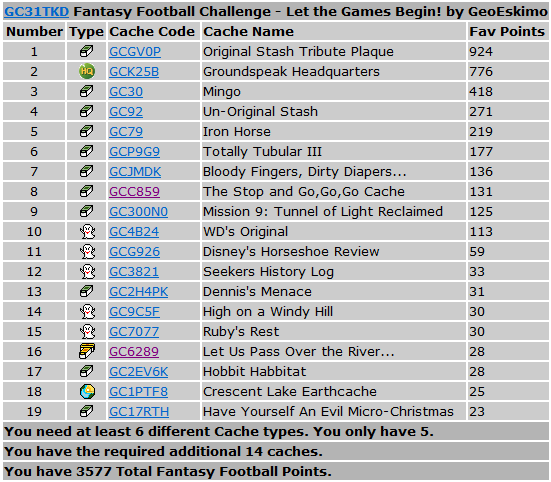
Let me know if you have any questions...
-TWT/Stephen
-
How do you get the information from GSAK? I didn't know that favroties were counted on the gpx files...
GSAK v8 uses the Groundspeak API to get the Favorite Points. It's still in Beta, but I haven't had any real issues at this point..
-
Being the thread starter, I might as well put my .02 in as well.
I see no reason not to. With an hour or less to setup the PQs I can save a lot of time in the future not trying to create routes or find the right radius that doesn't go over 1000 caches when I'm going outside my home area. With GSAKv8, It takes no time at all to check the box on the new PQs and it downloads and imports them all while I go and make a sandwich. I have a macro that calls a series of other macros that massages some of the data and creates a POI. A few minutes to load that in our 60csxs and Nuvi and we're all ready for where ever we end up that weekend... I'm heading to Spokane in a couple weeks and I have everything already there. If I had the room to run more PQs, I'd probably do the same for Oregon and BC, thats just the kind of guy I am...
I also prefer to use the GSAK maps or GeoSphere rather than the GC.com maps.In August, I went down into Oregon for a week (Oregon Star Party in Prineville) and created a number of Cache Along a route PQs for OR and WA. Due to timing and Forest Fires, I took a totally different route than was expected on the way there and on the way back. Entering Washington on the way home, I came into areas where I didn't have anything and wasted quite a bit of time sitting on the side of the road with my iPod on the GC.com website looking up local caches (the GC app is almost useless without a gps). I ended up getting 5-10 caches on the way home, but it could have been more.... Yeah, I could have planned better and had all possible routes.. Next year when I go back down to the OSP I'll have it all (atleast the WA side) and save the time..
 I've nudged the current chapter rep, and Jester's willing, we just need to align the planets. It would also be great to have some additional presenters, cos Jester's not always available. You interested? I could do a basic class, but I'm no guru.
 ) I like the idea of the batting average and may try to put something together in my FSG stats. I keep a Bookmark list of all my DNFs and LTFs and try and keep the DNF list updated with when I returned to find the cache or if it was Archived/Verified missing by CO, or whatever...
The Northwest Trails Project
in Northwest
Posted
Thanks the great maps!
I do have a question, but not related to the maps themselves... I use Garmin MapSource to load the maps into my 60csx. I just downloaded the updates and they are now in MapSource. Can I just bring up the saved profile from last time I selected maps and resend it? Will it automatically grab the images from the newer version, or do I need to remove the old maps from the list and re-add them? (Or start over)
Thanks!
-TWT/Stephen