


Rattlebars
-
Posts
579 -
Joined
-
Last visited
Posts posted by Rattlebars
-
-
FireFox is bugged. on GC.com I cannot get the mouse to click on the left side of the pages. F'risntance, if I want to hilite and copy the coordinates from a cache to plug them into google earth, it will not let me. It will hilite the whole page if I clickndrag from the left and if I try from the right, I can get to the first character after the "N" and it will hilite the whole page.
on the build pocket queries page, I CANNOT click the boxes in the left column to delete the queries. It simply won't click there.
IE - works fine, but I'd rather use FF.
Anyone else have this?
-
Premium Membership and Pocket Queries. You do not know how much gas not having to manually type in coordinates has saved me. You can upload with no typing boo boos. Even with today's prices, a premium membership would pay for itself in the year that you use in in saved gas alone and if you go paperless that will pay for itself as well. Printer ink is like $8000 an gallon. Don't take my word for it.....
-
-
I am going purely on the premis of windows. Just about any image on the internet if you right click it and look at the properties you will see a section called address/URL. Try it with the Groundspeak logo above. Right click it and look. You will see a complete path that ends usually in a .jpg or .gif filename.
Highlight the entire url starting with the HTTP://
Then right click and select copy or do a <ctrl> c.
Do a right click paste or <ctrl> v to paste it in the url section of the cache page.
That's pretty much it. Remember that sizing does happen so you might get unexpected results.
Have fun!
-HHH

WOAH THERE! BAD ADVICE! THAT IS SERIOUSLY BAD FORM! You are "stealing" somebody else's bandwidth which makes you a thief. What gives you the right to use an image from somebody else's website?
The best thing to do is use PHOTO BUCKET or some such free image storage website. Upload your background image there and record the URL of that image and follow the latter part of the instructions stated. THEN you can feel good about using it as a background image because you actually "own" the bandwidth and the server space.
-
One can get a nuvi 260 widescreen refurb on eBay for $140. Can't beat the price for the features. Text to speech with road names. BIG map screen. Coordinate entry just like here. 39° 41.666' 080° 62.444'. Voices include Jack & Jill American - Daniel & Emily British - Karen & Lee Aussie.
Don't be worried about refurb. What often happens is folks will buy this thing and then try it around town. Of course, YOU are much smarter and more familiar with your home town so your Garmin will want you to go the long way and you know a shortcut. Folks think, "This thing is stupid," and they take it back. Their loss your gain!
-
I can't count the number of times that I have held my GPS to my ear and had a conversation with the satellites......

-
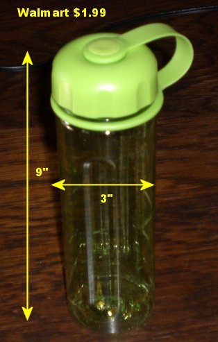
I think Wal Mart still has some of these left. They are very good. I tested it by filling with rocks and sinking in a 5 gallon bucket of water for 48 hours.
Bone dry inside after.....
$1.99
-
Internet Explorer 6.xxxx SP2.
Those who complain about stuff being at the very bottom of the page (like trackables) - don't scroll down, just hit the "END" key to go to the end of the page. It's over by HOME which takes you to the top of the page.
I'm not sure I like anything about the new site, but will list only a few things.
This is not pretty - it's ugly and unreadable.

Hints once just de-crypted right in front of you, now they reload the page which displays at the top often with the hint down a few scrolls. With GC.com that reload can take awhile sometimes.
Not overly fond on the font changes on /MY/ or other pages, but I'm just a curmudgeon on this one I guess.
Have to emphasize the ugly Avatar and information pictured and also the de-crypt stuff. One would not call those upgrades unless one works for Microsoft (then it would be typical).
-
Wow. I can't believe that I'm about to say this.....lets see how to say this in a family forum.......
its an adult toy.
How the heck did this make it past a reviewer?
man....I still hope there is some other explaination.
Steely Dan - Reelin' in the Years, Ricki don't lose that number.
And as any hardcore Steely Dan fan knows, the band itself is named for an adult toy in William Burrough's novel Naked Lunch.
-
Have teenagers taken over this topic, or is it just Animal House?
Modern values...... bethroom humor, the lowest form...
-
Ummm, why didn't you post the coordinates here.
I'm aware that it's a limited audience, but every little bit helps. I would personally find it challenging.
Type 'em out and put a local tag on it like "Near Mars, PA." If you are brave enough , list the phone number too....
-
Than "enter" button would the the "mark" button - that was easy!

-
Top of every cache page..... log it as a find. When you log onto Goecaching.com use the link "http://www.geocaching.com/my/" Click the box that says "Remember me" and you won't have to log in each time.
Your finds will be listed in the order you logged them. You can view all of them on one page by clicking that.
-
--> Click GooTech <--
-
Hi there, we are new to GeoCaching. There is a cashe in St. Albert that we would like to do that involves some compass bearings. Could any one explain to me how to find magnetic bearings? For example 119 Degrees Magnetic. If it is not too complicated and little lesson would be helpful.
See this thread.... >CLICK <
-
Projecting works good, but you are left with a single waypoint. If you mark the starting point (often a hard planted memorial or landmark) you can use the "rubber band" mode to make that arc....
6 of one, half dozen of the other. I prefer the latter.
And if you don't want to have to search a whole arc, and do not know if it's magnetic or true north based, and do not want to do a 'projection', you can use your GPS's settings to do the work for you.
I.E. Set your starting point as a waypoint. 'GOTO' it. Set your GPS to True north. Walk that distance while keeping the reverse bearing whats written in the cache till you hit the distance written. If there is no cache there then change your GPS to Magnetic North. And walk the short distance along the arc till the back bearing gets back to what's written. The GPS does the magnetic declination for you.
I thought I said that... but thanks for the clarification.
-
-
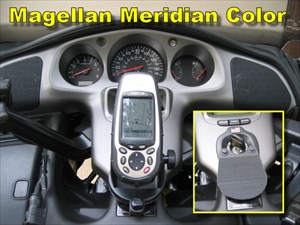
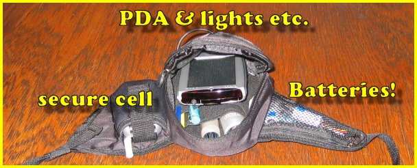
Magellan Meridian Color purchased off eBay for about $250 in 2005. I have never had the desire to change. This old girl has been faithful for the last three years and nearly never fails to take me to ground zero. At nearly all caches, she reads 3 to 6 feet.
She's been dunked for 20 minutes four feet deep in cold water. She was in my cargo pants pocket when we dumped the canoe during a blinding thunderstorm. We could not see let alone paddle to avoid those rocks there! Took twenty minutes to make our way to shore in a strong current. Lost one paddle, but the old girl hung on just fine.
She's been dropped to bounce about ten times down a stony embankment only to land face up and AT GROUND ZERO. She found that cache for us! Undamaged. Did I mention she's ACCURATE?
GPSBabel sends her waypoints through the serial port just fine. I have written several scripts and bat files that I use. One script changes the icons according to the size and type of cache. The bat files run GPSBabel and copy the GPX files to my DELL Axim 5. In seconds, I'm out the door, loaded and ready to go. I get turn by turn when that's called for and a rubber band / compass when I need them with just two clicks. She never fails to take me to ground zero.
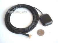
Two RayoVac Hybrid rechargeable niMH batteries last a good long time in her (longer, it seems, than straight up Energizers). And, one can plug in an external antenna which is magnetic, small and I have fashioned a little foam backed metal plate the size of the antenna. I put the metal plate under my hat and the antenna gets magged on the top (Yup, a propeller head for sure). She nearly never fails to take me to ground zero. Most times without the antenna!
I've often seen advice on this forum that says
Bull! When you get to ground zero and the cache ain't there THEN put it in your pocket. My old girl nearly never fails to take me to ground zero.When you get within thirty feet, put your GPS in your pocket and start looking.We just bought a Nüvi 260W for my mother in law and of course, we had to "break it in' for her. The Nüvi lost signal a number of times sitting right next to my old girl who never complained once. I can't fault the Nüvi, it was nearly on the floor of the car.
One can obtain a Meridian Color on eBay with its Mapsend software for a song these days.... I'm tempted to purchase a back up for the old girl when it's time to retire her (but I don't think that will be anytime soon).
Old junk? Depends on your perspective and whether or not you DID buy junk the first time.


-
Cardinal rule for GEOCACHING.
WHEN YOU PARK -- MARK!
Use your GPS and mark your parking place before you venture into the woods or even the urban jungle. One can get turned around very quickly when one is concentrating on looking for a cache rather than remembering which way you WERE going.
WHEN YOU PARK -- MARK!
One night at 3AM, I got myself turned around good and was lost in the woods on a moonless night! ALAS! If it were not for my quarter mile range REMOTE STARTER I would have spent a cold night in the bush. I started my truck which was just in range and which was DIRECTLY behind me when I thought I was headed FOR it.
WHEN YOU PARK -- MARK!
Folks will chime in with other help, but that is what I offer for a beginner.
-
In a very small parking area near the Shenango Reservoir in PA, I left my truck and headed to the cache. It was night (duh) and it was either when I reached into the truck to get my caching gear out or when I reached in to stash my caching gear back, my cell phone fell out of the holder.
Drove 30 miles home only to discover it missing!
Drove 30 miles back to the parking place and figured it would be a good trek trying to find it in the dark. But, LO! Look there! It's right here in the little parking lot. Bent down, picked it up only to find it was CRUSHED. One does not know if I crushed on the way out, or on the way in the second time. Worst part -- I thought of not pulling into the lot until I searched for the phone and decided, "Nah. What's the chance of that." Well, now we know.
Lost the phone one other time, but was only 5 miles from home. Same deal, discovered the phone missing upon driveway arrival. This one I knew was going to be hard. Dark of course, and I had missed an obvious trail in the darkness and had bushwhacked in.... one of those thorn bushes ripped it out of the holder.
I took my wife's phone with me and dialed my number frequently and found the phone only about 10 feet off where I had parked. Lucky that time.
I now have a "strap on" phone carrier for caching.... no more lost phones for me.
-
Change ALL of your equipment & software if possible to use the DDD° mm.mmm' format to avoid any confusion. If you go paperless someday, same deal....
Map datum is WGS24.
-
Otto
Just a guess, but is this it??
-
This is actually an interesting topic for me, although I am not even close to attempting of these caches (but a good one to save to favorites).
I think my GPS does allow me to "project a waypoint" (Garmin HCX Vista).
That being said, I would like to get a suggested website (not just do a google search, but one that will actually teach me something) to learn more about these orienteering basics - I know I am backing into this, but it would be nice to actually understand the process behind the GPS, instead of just following the GPS blindly.
Thank goodness I can mark the location of my campsite, it saves so much time when I head off to take the scenic route

Thanks in advance!

Projecting works good, but you are left with a single waypoint. If you mark the starting point (often a hard planted memorial or landmark) you can use the "rubber band" mode to make that arc....
6 of one, half dozen of the other. I prefer the latter.
-
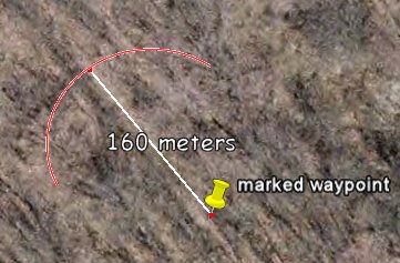
You have not indicated if the 286° is referenced to TRUE North or MAGNETIC North. Lets assume for Geocaching purposes they used TRUE North. A FizzyCalc projection or a GPS unit projection has already been suggested. Or you could just determine which direction 286° is. Mark your location and walk in that direction till the GPS indicates you are 160 meters away from your mark. Determine the magnetic declination for your area (difference between TRUE North and MAGNETIC North) in case you need to search both areas. Note for reference: West by Northwest is exactly 285°.
Whether true or magnetic, if you don't know which, just mark as mentioned, walk in the 286° direction and then search in an arc in the general area of the 286° at 160 meters. One can do this with no special tools nor access to internet or computer. Just use your GPS.
I always use an arc to search for these type caches like so:
 .
.

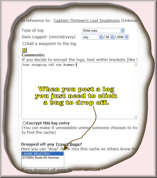

Why would people sign log sheets, but not log on webpage?
in How do I...?
Posted
Much better no log than a carbon copy mass logging like "Out with muggly mug on a caching spree. Found twenty."
Or, maybe not. I do like "found" logs online. That means more than likely the cache is still in place and healthy.
I'm an FTF hound which is one way to get me out the door.
I have 47 hides and it would be completely impossible to check the written logs on a regular basis, so online logs are nice for that reason.