

dpbabcock
-
Posts
21 -
Joined
-
Last visited
Posts posted by dpbabcock
-
-
I have 645 Contacts that are address based I want to convert them into Name plus the Cordinates so I can upload them into my 60CS is this possible.
I have them in a TAb delimited format, I need a software that can read them then output them to GPX.
Can this be done? Any ideas? I dont want to have to enter them one by one by hand.
Well, I'll be. Google wins again. Check out:
Looks like that will do just what you want and it works with tab delimited files. They say you can download the results to Google Earth. If so, you can probably export the KML format info and use BabelGPS or something similar to put it into GPX.
Just tried it. It works. This is fantastic. I can take this and load the coordinates right into my phone GPS app. Google has some really cool geocoding stuff.
-
I have 645 Contacts that are address based I want to convert them into Name plus the Cordinates so I can upload them into my 60CS is this possible.
I have them in a TAb delimited format, I need a software that can read them then output them to GPX.
Can this be done? Any ideas? I dont want to have to enter them one by one by hand.
The trick is in converting the addresses into coordinates (unless I misunderstand your post and you actually already have the coordinates in one of the tab delimited fields.
Somebody out there may know of a web service that will provide lat/lon from a street address but I'm not aware of it (I'll have to do a search, that would be handy.) Actually converted the data in a tab delimited file to GPX would not be difficult. It is a small matter of programming (SMOP).
-
I was thinking something kind of just the opposite recently. Here in Dallas and surrounding suburbs, they recently installed red light cameras at various intersections. It would be nice for Garmin and other GPS manufactures have a warning sound that would work in conjunction with a waypoint symbol. That way you could input the various redlight cameras, known speedtraps, and other hazzards like quicksand to remind you as you approach with caution. I know I could just slow down, quit running red lights, and falling into quicksand, but what fun would that be. :-)
Uh-Oh. I can see it now. Some liberal in the legislature will use that as an excuse to ban the use of GPSr's in cars like they've outlawed radar detectors in many states.
What we need is a real time database of speed trap locations. Not that any of us would ever speed (wink, wink). I could add that to my cell phone GPS app. Just press the "Mark Speed trap" key and the phone would snap the coordinates from the GPSr, post them on the web site in GPX form and anyone could download them (even while mobile via your cell phone)......Whoops....getting carried away here on flights of fancy ;-)
-
loc and gpx files are simple text files and can be opened with Notepad or any text editor.
 ImpalaBob
There are two different GPS-related .loc formats.
The GC one is xml and the original topographics (expertGPS?) one is binary. Editing a binary .loc in Notepad would likely be suboptimal.
Even editing TEXT (XML) is suboptimal if what you have in mind is getting them into your GPS. What EasyGPS does for me in that regard is handle the conversion from .loc to Garmin format and more importantly, the whole serial communication with the GPS. Being able to READ and EDIT the files is one thing. Getting them loaded into your GPS is another. I don't think the guy has hand entry of what he can read in the text file in mind. I'm assuming he wants an electronic transfer of the info into the device.
I wrote my BTGeoCacher software to use the GPX form (at least my stripped down version of it.) I only use the wpt, name, and cmt elements and I strip off the rest because it works Over The Air and most folks using the cell phone HTTP features pay by the amount transferred. I want to keep the byte count minimized. In my case I only need the waypoint, the coordinates and the BRIEF cache description. I don't want to pay for downloading the log entries and the other descriptive prose when they aren't really of much use in a cell phone setting. Displaying logs on a cell phone screen just isn't worth doing (IMHO). I just don't want to have to hand enter coordinates. I think that was the intent here. Even if you don't use the other features of EasyGPS, it will handle the job of commuinicating with your GPS nicely.
-
You might want to do some craigslist searching or other source becaue if you want a pda bluetooth and mapping you will have to squeeze to stay in a $250 budget.I would recomenfd whatewver bluettoth gps you go with to make sure it is the sirf3 chip in it.They are only a small price difference more but definitely worth the $$$.
Yes. If you back out the minimum of $70 for the BT GPS, you have about $180 to play with for the PDA. That may be a bit tight.
-
Well I use to have an etrex legend . When you turned it on it would say this unit belongs to .... ...... <my name. and had my phone number if it was ever lost or stolen. well it got stolen , and no one ever called. But now I have a new one , exact same , but I have read the manual and cannot see how to enter this info , any one know ?
I did it to mine but I've forgotten how. I think it may have had something to do with holding in the joystick switch while powering the unit on or something like that. I just scanned the downloaded manual and I didn't find it.
-
For a free solution, get EasyGPS. It will take your .loc files and allow you to download them to your GPS. But you'll soon find it so neat that you'll want to pay for it's big brother Geobuddy. Go to www.easygps.com. I used the former and upgraded to the latter within one day to take advantage of the super topo and sat photo overlay info you get. Once you've tried Geobuddy, you'll like it. But if you want a freebie tool to handle your .loc files and get them into your GPS. EasyGPS is hard to beat.
-
I am really wanting to go paperless in a big way, and want to get away from my first gen Lowrance iFinder.
Doing a little research I have found numerous bluetooth receivers, even solar-powered for less than $100.
Question 1: I you had $250 to spend, which BT receiver, PDA, and software would you go for?
Question 2: What is the "barebones" minimum cost setup that would best serve a cacher? I'm talking the cheapest serviceable unit. (Keep in mind that I only want to use a bluetooth receiver.)
Thanks in advance!

My next unit will probably be an I-Blue 737.
http://www.buygpsnow.com/i-blue-edition-2-...on-off-679.aspx
It looks pretty good and you can't beat the $70 price tag. I actually own and use a Wintec WBT-100. I bought it because of the built in compass but I ended up not using it that much. If I were doing it again I'd buy the WBT-200 (same thing sans compass and ten bucks less.) I use my cell phone (see link below if interested) for the readout but the nice thing about these BT GPSR's is that you can use them with anything that will take a serial NMEA data stream. You can buy a Bluetooth USB dongle for your laptop (I've seen them for as little as 12 bucks) I bought mine at a local computer store and it came with the Blue Soliel software. That seems to be popular on the PC end of things. I can't help you with PDA choices as I don't use one. My cell phone has all the PDA I need (g). I like DeLormes products for PC use. I think they have PDA offerings as well. Check them out at www.delorme.com
If you already have a BT PDA or Cell phone then the absolute "cheapest" is to just get one of these little GPSR's and somebody's software. FWIW, if your PDA or Cell phone can run Java Midlets (Java 2 Micro Edition) I'd love to have you test my software and let me know what you think. See the link below for more info.
-
Who buying online and from what sites
thanks
Troy
I have bought two now from www.buygpsnow.com. I had to return the first unit as it failed within a day of purchase and the return service and customer service was outstanding. The second unit I bought as a replacement has worked flawlessly. I recommend these folks for their customer service. Prices are competitive and they have a lot of different makes and models. They also offer some "freebies" (like dash vent mounts) with a number of their products.
-dB
-
Thanks for that excellent summary. If you happen to be with one of the few carriers with which Trimble works, that looks like a very nice option. And the price is sure reasonable.
I can understand that the logging/download stuff wouldn't work when you are out of range of cell service but what about the basic GPS? If you've got your waypoints loaded in, do you have to be connected to just do the GPS part? That doesn't seem likely but I just wanted to get clarification on that point.
As far as the antenna/receiver sensitivity I've seen other posts to the same effect with respect to the GPS's that are built into the phones. Getting all of that RF gear to co-exist in a small space is no mean feat. Also, even on disparate frequencies there is a phenomenon called "de-sensing" where an adjacent transmitter in near proximity to a receiver will reduce the reciever's sensitivity. In the "built in" the GPSR is in the same case as the cell transmitter. I know the transmitter is periodically active even if you aren't on the phone. I'm sure that was a challenge for the engineers from an RF point of view. Obtaining RF isolation from the cell receiver stages is also an issue. At these GHz frequencies having the GPSR even a foot or two away from the cell transmitter in the phone reduces the likelihood of de-sensing significantly.
Another place where I think the "separates" have an advantage is in mobile use. I can just toss the "hockey puck" GPS up on the dash (when using it for car navigation) and anyone in the car can use the redout (cell phone or PC.) The other advantage from a cost perspective is that the one device serves both my hiking needs and my travel needs. It is really nice to be able to use the same device with my DeLorme map software on the PC. I usually have at least one of the children "beg" for the privilege of holding the PC and watching the moving map display as we travel. With Bluetooth, you don't have the cabling issues. That was a hassle with my old DeLorme setup using serial cables. With a GPS built in to the cell phone, you have to have the unit up on the dash where it can get a clear shot at the satellites and that in turn makes it hard to read. I much prefer the bigger display of a PDA or PC for in-car navigation. The less time you have to glance at it to read it, the less time your eyes are off the road. The little BT units work in any of these use cases.
Lately it's been cold and I've just put the little GPSR inside my knit pullover hat when caching. It seems to receive nicely up there ;-) The phone I either look at periodically while walking or turn on the "sonar ping" mode and just listen to it tell me I'm getting "hotter" or "colder" with respect to the target.
But whatever you use is certainly better than nothing. It sounds like if you already have the Sprint phone and service, it's hard to beat another few bucks a month to get the value add to your phone. I know I've sure gotten a lot more use out of my phone in that respect.

-
I think your on a good track!
You might consider different software for the differing needs of Individuals. For instance. I use my GPSr for surveying/mapping types of applications. I have no desire to use it for geocaching. Concentrate on one type of need, and make the best software you can for that particular need. Capturing point coordinates and moving them from a GPSr to a computer is critical for all types of users, as well as moving coordinates from a computer to a GPSr.
In other words, keep the software short, sweet, and simple and targeted to a particular audience. Lots of software people have failed trying to do all things for all people.
I agree 100 percent. And thanks for the advice, BTW. I'm just having fun mixing a couple of my avocations and my vocation. I'm a professional software engineer and general all around techie/nerd. Geocaching has become a fun way to have an outing with my girls (they love the "treasure hunt" aspects.)
I built in the ability mark waypoints and edit/save them in the phone. I've written the download part so that I could directly work with my pocket query files from the geocaching site. It just uses the browser built into the phone for the data transfer. I've already mapped out the upload function. It will use either the browser and/or Bluetooth to "send" the waypoints in GPX format to the PC or a server web page. That seems to be a popular data exchange format.
Fortunately, developing for cell phones kind of forces you to be focused. The devices don't have a lot of memory and storage and so you have to be "to the point" with your apps.
It was a lark at first but it turns out that adding the simulated "sonar" ping feature based upon distance actually was quite useful. When I'm walking in the woods and getting close I can watch where I'm going while just LISTENING to the pings get faster or slower with the cell phone in my pocket (keeps both hands free for managing branches too) as I get nearer/farther from the final target. I've stepped in a few holes while focusing on the GPS and not where I was going (grin.) Plus it allows me to focus on LOOKING for the cache. I find those last ten or fifteen feet the most challenging! My wife thought I was nuts until she saw it work in the field (big grin.)
-
Palms definitely run J2ME - the Palm website offers the runtime they licensed from IBM. You install the runtime on your Palm, and then can run java apps, of which few seem to exist, at least any worthwhile. I removed the java runtime from my Palm, because it just took up space for no good purpose. One app that does use it is Opera mini, a web browser, but since I don't have wifi, or want it on my Palm, I don't need a browser.
I can connect my phone to my Palm, but I get no GPS information. I can transfer files, such as mp3 and pictures, but I don't do it that often.
Yep. Most of the Bluetooth stuff I'm finding has more consumer oriented connectivity - swapping pix, contacts, messaging, etc. Like I said, I would be really surprised to find that the cell phone manufacturer exposed the NMEA output from the GPS built into the phone. It's possible technically but they just wouldn't conceive of anyone wanting to do that and so wouldn't build it in. At least that's my take on the "gestalt" which seems to accompany most of the phone designs I've seen.
Even if you had the Java stuff on your Palm, the critical issue is whether it supports JSR 82, the J2ME Bluetooth API spec. I have a RAZR (old V3) that has Bluetooth built in for things like a hands free headset but as it turns out, they kept it proprietary in that model and the J2ME firmware on that phone DOES NOT support the J2ME Bluetooth "stack." Ironically, Motorola was one of the first big contributors/proponents of JSR 82 but they've been more tardy than some other manufacturers in actually getting it into their phones. At least that's my understanding from the surfing that I've done on the matter. That's the reason I went to the W810i. I'm not really into "Walkman" capable phones but this little gem was one of the few phones available for upgrade by my carrier that had a rather thorough J2ME JSRxxx suport stack. You generally have to look on the manufacturer's website for that kind of info. It typically is NOT something your local office will even know.
-
Just a shot in the dark on this. Has anyone attempted to connect their bluetooth enabled PDA to their Bluetooth enabled cellphone to access the cellphone's GPS reciever? The combo I'm specifically working with is a Palm m500 with a TDK blueM Bluetooth adapter and a Sanyo Katana.
It happens that I've been doing a lot of research into Bluetooth connectivity and GPS options of late (see story elsewhere on this forum or in my sig link below.) I would say that it is unlikely that the phone manufacturer "exposes" the internal GPS in the cell phone via the Bluetooth connectivity of the cell phone in a way that you could access it with your TDK. It's possible but I haven't seen that much creativity in the cell phone manufacturers. I do have access to a lot of developer technical data on cell phones and if you pass along your cell phone model I can see what I can find.
I'm currently using my Sony-Ericsson W810i as a GPS display connecting via Bluetooth to a Wintec WBT-100 GPSR. There are a number of these little BT GPSR's out there. I've got my eye on a $70 model (the I-767) at buygpsnow.com that looks pretty good. All of them emit the standard NMEA GPS strings that should work with any software that runs on your Palm. My "gig" is Java programming and I haven't done any Palm OS stuff. If your palm can run J2ME Java applications/games I'd be glad to have you try out my creation but I don't think Palm devices can run J2ME (Jave 2 Micro Edition) applications. But the up side is that there seem to be a large number of Palm offerings for GPS related software. Since your TDK effectively gives you a Palm serial port connection via Bluetooth to a Bluetooth device, you should be able to use any of these little hockey puck receivers for navigation.
I just attach mine to my cap where it gets the best sky view and go caching with my phone. You could do the same with your PDA.
Also, you'll probably find that any of the little GPSR's will be MUCH more sensitive than the GPS built into the cell phone. I've heard that the built in units are not nearly as sensitive as dedicated units. But I don't have any hard data on that.
-
How much does it really end up costing you? Is it just the Trimble subscription fee, or does it pile on airtime charges well?I've used the geocache navigator on my RAZR.$6.99 a month for the application. Airtime is included in my vision plan.
Which RAZR? Who is your carrier? My old RAZR V3 doesn't seem to have any GPS capability (and the Bluetooth is proprietary.)
-
Since my two daughters (my best geocaching buddies) always seem to want possession of the family GPS (Garmin E-Trex Legend) I began to look for options on purchasing another GPS so dad could have some fun too! Shortly after starting my hardware search I came across these little Bluetooth GPSR "hockey pucks" (they are about the size of a small box of matches) and I became intrigued by the idea of leveraging my cell phone for the display device. You can get the little GPS units for as little as $70 and I already had the cell phone. A lot of cell phones and PDA's have Bluetooth connectivity these days. Unfortunately, it turns out that MOST of the cell phone application software out there for GPS use is oriented towards street navigation. I wanted something that would be more useful for geocaching. Being a Java programmer, I decided to write one. After all it isn't really that hard to parse the NMEA strings that come out of the units. The only thing I had to do was parse it and figure out how I wanted to display it. I've been field testing the result for a week or two and would like to open it up to anyone else interested in testing. This may have commercial possibilities down the road. You can see some pics of my setup at http://www.btgeocacher.com if you are interested. If you have one of these Bluetooth GPSR's and would like to try it out with this application and your Bluetooth enabled cell phone, I'll be glad to work with you. Just drop me a line.
FWIW, I've done extensive side by side comparisons for accuracy with my Garmin E-trex legend and I've been amazed at the quality of these little GPSR's. Also, they seem to have newer GPS chipsets (like the SIRF and others) which I can attest are DEFINITELY more sensitive. I can get fixes in my basement with the little Wintec unit I use where my Garmin will barely see even one or two satellites.
-Don Babcock
de N5DP
-
I haven't used their product but as I understand it, it only works with cell phones that have built in GPS's. Is that right? I'm currently using my cell phone as the display device for an EXTERNAL Bluetooth enabled GPS which I've found much more sensitive than my Garmin E-Trex. I haven't heard about the sensitivity of those GPSR's embedded in the cell phones vis-a-vis other units but I suspect that they aren't as sensitive. I'd be interested to hear of actual experiences since I'm developing along similar lines.
-dB
-
Chuck, why are you using an adapter with your camera? The camera is USB, I'm sure - I've never heard of a camera with a serial connection. If you are trying to connect a USB device to a serial port on your computer, then you need a different device.
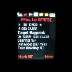
Mr. Babcock, I've been flying for 40 years, professionally, and I say once more, your heading is the direction you're moving, or at least facing, while bearing is the true (or magnetic) course to your destination. Your heading while flying may not be exactly the same as the course made good, but the bearing to the destination or station is always the direction to it, regardless of your heading or course made good. What you're depicting on your eTrex is the bearing.
Well after doing a bit of research, I believe you are correct. I stand corrected. The common usage seems more in line with what you've said. I knew what I *meant* to say but it looks like I got it backwards from the purest definition of the terms that I could find in some on-line resources. Thanks for working with me on that. I like to get the details right. Programmers (geeks) are that way. I've got to change the "Heading" label on the screen to "Bearing"
 I was just sitting here working on the program and just got the "Over the Air" (OTA) GPX file download working and took a break to check up on my other on-line interests (including this forum) and I saw your reply.
 Many times I've loaded up the waypoints I thought I needed before a caching session only to find out that I had forgotten some when I got in the field. Now if I have cell coverage I can just point the app to the GPX file URL on the web and suck them all into the waypoint list directly OTA. I'm getting truly spoiled by this wireless stuff, especially the Bluetooth. I wish the E-Trex had that capability. It always seems that the cable is not handy and it's a bit of a nusiance to hook up. It's SO nice to be able to load data just being NEAR the PC (like synching your appointments, addressbook etc.) Now I can load waypoints anywhere I have cell connectivity WITHOUT a PC right in the middle of the woods if I need to. I'm having way too much fun with this (g).
Anyway, you've done me a service by helping me get the terms on the program screen right. If I get this thing polished enough to market it, you'll get a free copy if you have a Java enabled cell phone or PDA that can run it. Just look me up and remind me of the offer (g).
Thanks again.
-dB
-
If I read your post correctly, I think you've transposed heading and bearing. Heading is the direction you're moving, bearing is the true direction to the destination, which is what you want. I do agree that bluetooth is the way to go if you're connecting a GPS to a PDA. If you already have a high-end GPS and want to make it bluetooth-capable, PC-Mobile sells an adapter that will work with just about any GPS. I connect it to my Legend and my RS Digitraveler, which was produced long before bluetooth was even conceived.
Actually, I think I got it right. Heading is with respect to North (either magnetic as when I'm flying using the compass for reference) or True (as when I'm computing relative to meridians. The HEADING from where I am to where I want to be will always be the same (think of your Directional Gyro). So if I'm Southeast of my target, the HEADING will ALWAYS be NW. However, the Bearing is relative to where my nose is pointed. So if my HEADING is say 315 degrees, my BEARING will be 45 degrees to the RIGHT if I'm westbound but if I happen to be pointed east the bearing would be 135 degrees to the LEFT. Bearing is relative to your nose. Heading is relative to "North" (either magnetic or true depending upon your reference.
Practically, when you are trekking through the woods using the directional arrow on the Garmin E-trex, it points RELATIVE to the unit as you hold it in front of you and walk a straight track. But if you start turning with it and don't give it time to establish a new ground track, it will lead you astray. For a simple case, walk a bit in a straight line then stand still. You can rotate the GPS around in your hand and the arrow will just stay put. The GPS can't "know" which way it's going if you aren't moving. And even then it assumes you are walking with the "top" of the gps pointing forward. If you walk holding it "backwards" in your hand it will point in the opposite direction. That's because it doen't "know" how you are holding it.
So when I'm in the woods especially when you get in close and you are turning and looking, I want the readout to give me the HEADING, NOT the relative bearing. I generally will know which direction is "North". If in doubt, take a compass. The little 4-in-1 unit I mentioned actually has a built in magnetic compass LED that will glow solid when the unit is oriented to magnetic north. But generally sun position will give me enough directional orienation. I've seen my kids chase off following the bearing arrow on the E-trex as it swings wildly because they keep changing their ground track. As a pilot, I want the unit to tell me that my target is at 315 degrees at 500 feet regardless of which way I happen to be walking at the moment or facing and regardless of how I hold the unit. I'll get to the cache much quicker that way, especially when I'm having to weave through the woods picking my path.
I guess I'm using HEADING in the same since as one thinks about it with respect to the DG in an aircraft. If I make my AC HEADING agree with the HEADING info on my GPS, I'll be flying TOWARD the target (assuming no wind and a DG that is set properly.) The HEADING from my present position to the target doesn't change but If I'm doing steep turns around a point, the BEARING changes constantly. Heading to target doesn't depend upon which way I'm pointing at the moment. Bearing does. At least that's my concept of it. Hence the term: "relative BEARING." It's relative to the nose of the craft.
Anyway, what I wanted out of my software was a readout that says "315 degrees" when the target is NW of me regarless of which way I happened to be walking or facing at the moment. In fairness, the E-trex DOES give that kind of info but for novices, it is very easy to fixate on the arrow without taking into account the other readouts (like the changing compass card background on the display). Having a simple decimal readout of the heading offers fewer opportunities for misunderstanding. This is especially critical during the last few feet when the GPS is "dithering" due to the leaf canopy and you are pacing back and forth in the area doing the "hotter-colder" mental averaging of the distance readout. With the E-trex I keep having to remind the kids to ignore the arrow and just focus on the distance readout, walk a few steps in some direction and see if they are generally getting "hotter" (closer) or "colder" (farther away.) With the cell phone, there isn't any arrow to distract. Just heading and distance. This seems less prone to error.
-
If you are looking for GPS solutions of the PDA or Laptop variety, I would strongly consider the Bluetooth option. There are LOTS of Bluetooth GPS modules out there, several well under $100. In addition, many of them feature the latest SiRF chipsets which are indeed much more sensitive than older equipment. I placed my Wintec 4-in-1 Bluetoth GPS right next to my Garmin E-trex in my basement window and the Wintec easily aquires a solid fix whereas the Garmin can barely see a satellite or two from that location.
The other thing I really like about the Bluetooth option over either USB or Serial is NO CABLES!!. I just chuck the little GPS "hockey puck" up on the dash and the laptop/PDA can be anywhere (I typically have one of the passengers running the navigation on long trips. )
If your laptop or PC doesn't come with built-in Bluetooth, you can buy a Bluetooth USB dongle for around $20 from your local computer store. The included drivers and software will make it look like an ordinary comm port so you can use it with Delorme Street Maps or any other software that does NMEA over a comm port. The only issue there that I've heard of is one report that Microsoft's Streets software didn't allow a high enough baud rate in the case of one installation. But I view that as an M$ problem.
In my case, I use my bluetooth enabled cell phone (many are these days) as the "readout" for the GPS. I just wrote a little Java app that runs on the phone designed especially for geocaching that allows me to enter and mark waypoints and select them from a list. Then it just gives me HEADING (as opposed to bearing) and distance info. As a pilot, I much prefer working in terms of headings. I've seen my children go off in the wrong direction using the BEARING pointer on the E-trex. That can "lie" to you if you change direction until it figures out your new ground track.
There are a number of navigation programs out there for various bluetooth enabled cell phones and PDA's. Once you've been liberated from the CABLE hassle of either USB or serial, you never want to go back. I'm even going to sew a little pocket in one of my ball caps to hold the GPS "puck" and use my cell phone when geocaching. That way I won't have to fight the kids for the E-trex (grin). Besides, when you are walking in the woods with your PDA, cables snag on every branch.
Give Bluetooth a try. You'll like it!
-
When we go out family caching, there is always a "discussion" among the youger ones about who gets to hold the GPS (on multi-caches, we have the kids swap on legs..). So Dad (that's me) began to consider options for getting another GPS. I'm also a programmer and wanted to try my hand at handheld device programming so I started looking at little Bluetooth GPS units that I could use with my cell phone. I tried a HOLUX GPSlim unit but it had problems and I sent it back in exchange for a Wintec 4-in-1 unit (Bluetooth GPS, USB GPS, logger, compass. ) This unit uses one of the new high sensitivity chipsets. In terms of time to aquire a fix and sensitivity, it puts my E-trex Legend to shame. It will aquire and hold a fix when my E-trex right next to it can barely see a satellite or two. I'm very impressed with the unit. Now understand that these units don't have any displays other than some blinking status L.E.Ds. The position data is transmitted WIRELESSLY via Bluetooth to your phone or PDA and the readout happens there. A number of cell phones are coming out now that can use this technology. Some have built in GPS's but these are generally not nearly as good as the stand alone units.
My intent with this unit is to sew a little pocket in one of my ball caps and just wear it in the woods when caching. Then I just use my cell phone to read out the coordinates. So far the accuracy and sensitivity has been amazing. You can buy them for about $100 at various GPS outlets. The Li-ion battery lasts for much longer than I typically cache and the units typically come with BOTH chargers (AC and mobile) as they are typically intended for use with PDA's or laptops in the car. The output is the standard NMEA strings and should work with any PC and software that uses either USB or Bluetooth "com" ports. I can use the same unit with my laptop and software like DeLormes to get to the caching location and then hop out and use the same unit with my cell phone (I'm using a Sony-Ericsson W810i) to find the cache.
I wrote a small Java program that runs on my phone that is especially designed for geocaching. Most of the other software I've looked at seems more oriented to salesmen and street navigation. But you can use street nav software too. So if you have a Bluetooth enabled cell phone or PDA, you might want to consider one of these little units to leverage your phone/PDA into serving your GPS needs as well.
 ImpalaBob
 I was just sitting here working on the program and just got the "Over the Air" (OTA) GPX file download working and took a break to check up on my other on-line interests (including this forum) and I saw your reply.
etrex legendcx VS Vistacx
in GPS technology and devices
Posted · Edited by dpbabcock
I will say that my girls have had trouble getting used to the idea that the "arrow" (bearing mode) doesn't REALLY always point to the target. It only does so if you've moved enough in a straight line with the Lengend held in front of you so that it "knows" which way you are going. This makes perfect sense if you think about it. The gps can't "know" the case orientation in 3D space. If you don't believe that, walk as you normally would but hold the case backwards (i.e. top of the unit behind the bottom as you walk.) The bearing indicator will be 180 degrees out. This MAINLY causes a problem for them when they get close enough to start "hunting" and don't realize that the GPS takes some time after they've mad a turn to update its view of which way you are going.
I've about settled into the "ideal" rig for what I'm doing. I carry a clip board and I will mount the GPS on one side and a magnetic compass (like the Silva) on the other. All I really need is a rough idea of where North really is so that I can realize where the GPS Bearing is really telling me to go. Most of the time that's not hard with the sun out but on overcast days in unfamiliar woods it can be an uncertainty. I prefer the separate compass. Also, as was pointed out, a magnetic compass can be very affected by adjacent fields. Now in the case of a GPS, there is no question that there are built-in EM fields. For land navigation, I much prefer a reliable compass that I can distance from any metal or electrical items for a good reading. While I'm sure the design engineers of the units with the built in compass/hall effect devices have done a good job. I've come to trust the tried and true compass. Besides, if you are lost in the woods and your GPS batteries give out, you can still get out reliably with your trusty compass.
Back to the girls - I'm trying to get them to become aware of the actual readout of the bearing in numerals and become positionally aware of what that means with respect to North. My one complaint about units like the Etrex Legend (which is the one we own, the B&W display model) is that the "arrow" displays tend to lead novices astray, especially in the "red zone." I tell my girls to switch over to the MAP mode when they get close as that gives a "North UP" depciction and they can visualize the relative position of the cache with respect to a NORTH UP map presentation. It's part of the "art" and skill of orienteering/land navigation and developing proper "situational awareness" (a little pilot lingo there.) When you are "turning and burning" close in to a cache, the E-Trex vector display will "lie" to you if you aren't mindful of the compass rose state.
When I wrote the BT Geocacher, I deliberately designed around numeric displays rather than using a vector display. This forces you to just be aware of where "North" really is at all times. A compass, even a very basic one, can provide that. If I know where NORTH is and the bearing to target is 225 then I know it is South West.