

Colorado Papa
-
Posts
506 -
Joined
-
Last visited
Everything posted by Colorado Papa
-
John & Shirley, Does this mean you are going to claim Hurefano Butte too? Dang, and here I wanted to be the one to climb up there and get it. Maybe I should just cheat and claim it now?
-
Rob, Is this an example of one of the simpliest and satisfactory recovery submissions? GM0500'RECOVERY NOTE BY GEOCACHING 2004 (TWS) GM0500'RECOVERED IN GOOD CONDITION. HANDHELD GPS COORDINATES N36 35 27.4, GM0500'W105 57 21.9.
-
Rob, well said. My suggestion was a tongue-in-cheek remark. I enjoy seeing "new" people coming to this forum asking questions, and even picking up some who do find BMing more enjoyable than caching. However, there are a few minor things "broke" in the benchmark section that have been listed in the pinned string. Perhaps someday Jeremy will get back to this section to do an overhaul. Now how many here know about being able to "forum" message directly to another person on here? I just found out about it last week from John (2oldfarts), and I've been on here for three years! Amazing what these little icons do. In case you don't know what I'm refering to, try the PM icon under each post. Too bad the profile icon doesn't work. I'd like to see more detail about my fellow benchers. Ted
-
You maybe onto something. I would not call it a professional site, but those of us who are really serious about this and want our own forum could probably do it for $10/year providing we could get at least ten parties involved. If we had twenty, the cost could come down to maybe $5.00. Anyone else have thoughts about it?
-
I am preparing an email for Deb to present to Burt. Here are the highlites of the argument. Please make suggestions for improvement. Thanks, Ted Deb, Here are my arguments that PID GM0519 and GM0837 are for the same station. Picture of station in question: http://img.Groundspeak.com/benchmark/lg/2e...cdd2b1773a6.jpg In 1925, GM0837 HISTORY - 1925 MONUMENTED USSC GM0519 HISTORY - 1925 MONUMENTED USSC Why would USSC mount two of the same markers at the same east-west location in 1925? In 1933, a north-south survey line was run along the railroad mounting GM0567 (A 32). See GM0517, GM0518, HK0394 and HL0076. The crew probably found GM0837 but could NOT have given the description about the dismantled railroad since it existed until 1941. .1925 Supreme Court Decision: http://caselaw.lp.findlaw.com/cgi-bin/getc...ol=267&invol=30 Picture of GM0517: http://img.Groundspeak.com/benchmark/lg/99...cf4393daa49.jpg Picture of GM0567: http://img.Groundspeak.com/benchmark/lg/02...616aad0b275.jpg In 1935, reference and an azimuth marks were established for the 1925 mounted station GM0837 as can be seen by date in next picture. Picture of GM0837 RM2 with tape measure from station indicating 100'+7' 6-1/2" (measurement taken with 50' tape): http://img.Groundspeak.com/benchmark/lg/9a...dc9aebfd7cb.jpg Picture of GM0837 RM1 remains. Measured properly from station: http://img.Groundspeak.com/benchmark/lg/6a...6fcd6a17053.jpg Picture of the area: http://img.Groundspeak.com/benchmark/lg/a4...96f853bc305.jpg
-
LSUMonica, From the very first post and very first rule by Black Dog Trackers, your picture does not qualify. Sorry.
-
Disregard the previous post. Apparently the subject has not been resolved, yet.
-
Well, THANK YOU!!! I didn't think anyone would notice the pics I post. Sheez, I hope you didn't see the error in one of my pictures. Gotta go back and see if I can find it. Think I posted a closeup of V 44? for W 44? or visa versa. HEY GANG, I MADE ANOTHER BOO_BOO!!!
-
In looking back at the Archived_Datasheets , I came across one I had updated last year that has some interest. This mark is very obvious as you enter City Hall. Read what NGS said. With the modified description, perhaps next time they won't miss it. JK0210'DESCRIBED BY NATIONAL GEODETIC SURVEY 1935 JK0210'AT COLORADO SPRINGS. JK0210'AT COLORADO SPRINGS, EL PASO COUNTY, AT THE NORTHEAST CORNER OF JK0210'KIOWA STREET AND NEVADA AVENUE, AT THE SOUTH ENTRANCE OF THE CITY JK0210'HALL, AND IN THE STONE WALL. A STANDARD DISK, STAMPED COLORADO JK0210'SPRINGS 1934. JK0210 JK0210 STATION RECOVERY (1983) JK0210 JK0210'RECOVERY NOTE BY NATIONAL GEODETIC SURVEY 1983 JK0210'COULD FIND NO EVIDENCE OF MARK OF ANY KIND AT THIS LOCATION. JK0210 JK0210 STATION RECOVERY (1997) JK0210 JK0210'RECOVERY NOTE BY US POWER SQUADRON 1997 JK0210'RECOVERED IN GOOD CONDITION. JK0210 JK0210 STATION RECOVERY (2003) JK0210 JK0210'RECOVERY NOTE BY GEOCACHING 2003 (TWS) JK0210'DESCRIPTION SHOULD REPLACE THE WORDS AND IN THE STONE WALL. WITH AND JK0210'IN THE SOUTH END OF THE WEST STONE WALL ABOUT 3 FEET ABOVE STREET JK0210'LEVEL.
-
I don't mind being critiqued so I can do a better job of finding and reporting. Sorry if it offends you. But you are probably right that many of us in this section take benchmark hunting fairly seriously. You'll find several pros in this forum including Dave Doyle and his staff who are with the NGS (US National Geodetic Survey). If you can't stand the heat, get out of the kitchen.
-
Been out of communication for past few days. Just checked NGS for my submitals last week and I see Deb Brown agreed with me about duplicate entries and posted my findings: GM0519'RECOVERY NOTE BY GEOCACHING 2004 (TWS) GM0519'RECOVERED IN GOOD CONDITION. RM2 RECOVERED IN GOOD CONDITION. RM1 GM0519'HAS BEEN DESTROYED, ONLY CONCRETE BASE REMAINS. AZIMUTH MARK NOT GM0519'FOUND. THIS MARK IS SAME AS PID GM0837. GM0837'RECOVERY NOTE BY GEOCACHING 2004 (TWS) GM0837'RECOVERED IN GOOD CONDITION. RM2 RECOVERED IN GOOD CONDITION. RM1 GM0837'HAS BEEN DESTROYED, ONLY CONCRETE BASE REMAINS. AZIMUTH MARK NOT GM0837'FOUND. THIS MARK IS SAME AS PID GM0519. Case closed. The system does work!
-
All right! I'll give it another try... tomorrow, maybe tonight, if I can plug this laptop into something at the casino, and if I can get away from the crap table.
-
Paul, Will be happy to have your company, but don't come during the winter. I'm one of those "Winter Texans" that likes to golf year-round. (I'm originally from Minnesota and married a Texan 51 years ago. I didn't like Minnesota in the winter and she didn't like West Texas so Colorado has been home for 41 years.) Ted
-
em, mrh, BDT, Thanks for the suggestions. These all worked for taking me to the bottom of the string; "little blue down arrow icon", "End", "Last Post by:" ... However, going to the last post is not what I have in mind. I'm interested in going to the first post I have NOT read. I'll stay with my original post. Sure would like to see Jeremy add an icon for taking you to the first unread post, or change the little blue down arrow icon to that function.
-
From the NGS datasheet: DX1732* NAD 83(1986)- 33 39 32. (N) 117 17 56. (W) SCALED Looks to me that since the coordinates were scaled, you found them close enough. Consider yourself as a good locator. BTW, what were the coordinates you observed?
-
Goes to prove us benchers have a sence of humor.
-
What little blue down arrow? Edit: Oh, THAT little tiny box with the upside down ^ in it? Gee, learned something new again! Ain't computers wonderful!!!
-
MD, I'm the one who screwed this thread up. I should have started a new subject way back up the line when I started "crowing".
-
This may not be totally related to benchmark hunting, but after three years, 'bout time I learned something about this web section. If the rest of you have had to scroll down many entries to find the newest posts for various subjects, I just discovered an easier way to go directly to the first unread post. Click on your name for any entry you have in this forum which will open Groundspeak Forums -> Your control panel. In the left hand column under Options, click on Board Settings. Change the Number of posts to show for each topic page from default to 15 (more or less if you want). Now, when you open a topic, at the top of the page you will see something that appears similar to Pages: (3) [1] 2 3 ( Go to first unread post ) . Just click on the ( Go to first unread post ) and there you are!
-
OK, I have a new challenge. I was going to climb this Colorado butte to find the HK0510 station on top, but when I got to the base, I decided that a 75 year old should not be attempting this alone. So, if and when one of you want some company to log this mark, please contact me. This was the core of a volcano way back when. HK0510'THE STATION IS LOCATED ABOUT 9 MILES AIR LINE NORTH-NORTHWEST OF HK0510'WALSENBURG, ABOUT 0.5 MILE AIR LINE EAST OF U.S. HIGHWAY 85 (Now I-25), HK0510'87 AND HIGHWAY BRIDGE OVER HUERFANO RIVER, ON TOP AND NEAR THE HK0510'HIGHEST POINT OF HUERFANO BUTTE. THIS BUTTE IS A MOST HK0510'CONSPICUOUS, BLACK, ROCKY BUTTE, WHICH RISES ABRUPTLY FROM LOW HK0510'COUNTRY TO APPROXIMATELY 150 FEET IN HEIGHT. THE STATION HK0510'IS NEAR THE NORTH EDGE, 8 FEET EAST OF THE HIGHEST POINT, HK0510'SET FLUSH, AND IS STAMPED, HUERFANO BUTTE 1949.
-
You must be refering to using GC for the database. I'm in the habit now I seldom use GC for my source of information. Unless you want to see if some other cacher has found the mark, NGS has more detailed and up-to-date info. When you access NGS Datasheets, you have the option of searching by the following methods: PIDs - Permanent Identifiers Radial Search - provide center coordinates and radius in Miles Rectangular Search - provide min/max coordinates Station Name Project Identifier USGS Quad COUNTY Load Date Map Search - Interactive MAP retrieval. It was simple to put in only TT for station name and select INDIANA. This TT 18 D was the only one for the whole state.
-
Is this anywhere close? LB2203 DESIGNATION - TT 18 D USGS 1948 LB2203'STATION IS LOCATED ABOUT 8 MILES NORTHWEST OF LA FAYETTE AND 2 MILES LB2203'SOUTHWEST OF MONTMORENCI ON PROPERTY OWNED BY MR. RAYMOND BENNETT. LB2203'IT IS 23 FEET SOUTH OF THE INTERSECTION OF STATE HIGHWAY NO. 26 AND LB2203'GRAVEL ROAD NORTH, 4 FEET SOUTHWEST OF A CONCRETE FENCE POST AND 2 LB2203'FEET SOUTHWEST OF A WHITE WITNESS POST. THE MARK IS A LB2203'6X6 INCH CONCRETE POST WHICH PROJECTS 2 INCHES LB2203'WITH A STANDARD USGS BM DISK STAMPED TT 18 D 1939. A TRAVERSE LB2203'CONNECTION WAS MADE FROM TRIANGULATION STATION INDIAN AND THE LB2203'DISTANCE WAS FOUND TO BE 60.53 FEET (18.449 METERS). LB2203' LB2203'TO REACH THE STATION FROM THE JUNCTION OF U. S. HIGHWAY NO. 52 AND LB2203'STATE HIGHWAY NO. 26 IN WEST LA FAYETTE GO WEST ON STATE HIGHWAY NO. LB2203'26 FOR 8.5 MILES TO A T-ROAD NORTH AND THE STATION AS DESCRIBED.
-
It's too bad we can't move the posts from the other string to here. This has been another lesson in Surveying 101. Closest Macomb mark I could locate was near Macomb, OK. The monument may not be in the database. Anyone want to check out this corner marker that is under the cover and not just the cover itself? I see there have been three claims, but... GL1538 FBN - This is a Federal Base Network Control Station. GL1538 DESIGNATION - BOUNDARY MON CO KS OK GL1538'DESCRIBED BY BUREAU OF LAND MANAGEMENT 1990 GL1538'STATION IS LOCATED ABOUT 13 KM (8.1 MI) WEST OF ELKHART, KANSAS, AT GL1538'THE TRI-STATE JUNCTION CORNER, IN THE WESTBOUND LANE OF THE STATELINE GL1538'ROAD, AT THE JUNCTION OF SECTIONS 15 AND 19, T 35 S, R 41 W AND 43 W, GL1538'AND SECTION 13, T 6 N, R 9 E. OWNERSHIP--BACA COUNTY, CO, MORTON GL1538'COUNTY, KS, AND TEXAS COUNTY, OK. GL1538'NOTE--CONTACT TED HARDER IN ELKHART FOR HELP IN REMOVING LARGE COVER GL1538'OVER STATION. PHONE IS 316-697-2696. CONTACT PAUL GROUT, COLORADO GL1538'DEPARTMENT OF HIGHWAYS IN PUEBLO FOR INFORMATION ABOUT BLOCKING LANE GL1538'AFTER DARK. PHONE IS 719-546-5487.
-
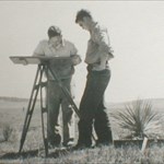
In locating 1/2 dozen BMs this past week that were reported as NOT FOUND by NGS made me wonder as to how long GPS has been used for surveying? Out in the boondocks along US Hwy 285 from Antonito, Colorado to Tres Piedras, New Mexico is the very dim outline of what used to be the Denver-Rio Grande narrow gauge railway. A survey crew installed marks along the railway in 1933. In 1984, another crew came along and installed marks along US 285. They used the railway marks where they could find them, but if they didn't find them, the mark was listed as NOT FOUND. Using my GPSr and the scaled coordinates, I was able to walk right up to the missing mark. I was surprised how close the scaled was to the actual location and initially thought the NGS did a poor search job. But then it occurred to me that they had a very poor description, especially since the railway was hard to distinguish in most locations. There were no mile posts or telephone poles, bridges gone, cuts and fill erroded away... They were lucky to find the ones they did! Here's what they had to put up with (GM0500)! Ah, modern inventions. Sheez, GPS would sure have made my Korean flying days a lot easier. I would have known what rice paddy I was blowing up. Edit to add picture.
-
Or even the history of ones you do find, such as being discussed about GM0837/GM0519.