

VisionQuest220
-
Posts
104 -
Joined
-
Last visited
Posts posted by VisionQuest220
-
-
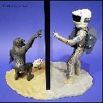
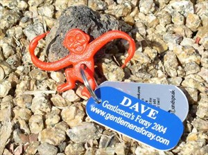
When I created The Gentlemen's Foray 2004 Cache, I included a number of travel bugs that included the URL for the group website. (See picture below.) We aren't selling anything but we like to see traffic on our site and perhaps inspire other groups of friends to have an annual event similar to ours.
I don't think it really matters what your travel bug is about, commercial or not. I think what matters is that you're having fun.
-
Whatever unit you decide to buy, do a search for it on eBay. I regularly find great prices on what are considered "used" units but often times only because they've been taken out of the box and turned on and off once or twice. I see eTrex Legends and Ventures selling for between $100 - $150 and they often include carrying cases, lanyards, DC charging cables and computer interface cables.
If you're not in a hurry, you're likely to find a great bargain.
-
If someone with a Quest wants to do the work, contribute it to the project (it IS open source - I don't have to do all the development myself) and help with the maintenance/support of it, I'll gladly work with them to include it.
How much technical knowledge is requred on the part of a Quest-owning volunteer in order to accomplish this task?
-
I dunno, I think perhaps WAAS-enabled GPS devices are becoming the norm so that Geocachers and other GPS users can use the universal greeting "WAASup?".
Bwahahahahahahahaha!!!
-
I own a Quest (which is a great unit for both auto navigation and geocaching) and there is a setting on the Map Setup screen that allows me to shift my display orientation between "North Up", "Track Up" and "Auto". "North Up" will always display North to the top of the screen no matter which direction you are heading. "Track Up" will keep your direction of movement to the top of the screen regardless of where North is and "Auto" switches between the two settings automatically. Again, this is in the Map Setup page of the Settings menu.
Hey, start having fun, dammit!
-
Thanks for more stuff that rocks!
ETA: Is Quest support coming anytime soon?
-
Hey Quest users...
Garmin has a software upgrade for the GPSr to version 2.90.
Be the first on your block to have the latest and greatest software version of latest and greatest Garmin GPSr!!!
-
I purchased and installed Cachemate 4.0.2 last week so I was surprised to learn that there was an updated version available. I've downloaded and installed 4.0.3 and I'm looking forward to seeing how much faster it processes information as I agree that 4.0.2 was slower than I liked. On the other hand, how much speed can you expect from an 8mb Palm IIIc?
-
Perhaps the "first to find" need is a form of compensation for having a small, um, GPSr!
Bwahahahahahahahahaha!!!
-
I have an older version, 3.00, of MapSource TOPO and I was trying the procedure for installing all the data from the discs on my hard drive so that I don't have to keep any of the discs in the drive in order to use the program. Since I live in the Western US I never use the "East" disc so I never noticed the huge circular scratch that goes around the middle of the disc which makes that disc entirely unusable.
What to do? Call Garmin!!!
The folks at Garmin are sending me a complete set of TOPO 3.02 as a replacement for the damaged disc for the bargain basement price of $22.70 ($15.00 for the discs, $6.00 S&H, $1.70 Tax), shipped via UPS Ground. They didn't even ask me to ship them the old discs in return.
That's what I call "Customer Support"!!!
-
OK, I'm off the phone with the folks at Garmin and the word on the "avoidance" issue is simply this: The software that the Quest GPS is running is more advanced than the current release of MapSource which is why the standalone program isn't currently as capable as the GPS itself. According to the Garmin Rep, Quest is the most recent, and therefore, advanced product that Garmin has on the market and it's going to take a little while for the older programs to catch up. He told me that he'd pass along the suggestion and to look for it in future updates of MapSource.
Now we know...
-
If anyone knows of a way to do what I'm trying to do with this program, I'd be grateful to learn about it.
It would be nice to be able to set these avoidances from within MapSource and transfer them to the Quest in one shot but I don't know if this would be possible...
It never hurts to ask...so I will!!!
This is just another reason why Quest Rocks!!!
-
In MapSource, go to:
EDIT | PREFERENCES | ROUTING
Look in the lower left corner
"Try to avoid"
[ ] Highways
[ ] Toll Roads
[ ] Unpaved Roads
[ ] U-Turns
[ ] Carpool Lanes
Yes, I saw this but it's function is limited to allowing the program to determine what to avoid and what to use based upon these settings. What I'm referring to is the Quest's ability to specifically select a single street (or section thereof) to avoid. The MapSource feature is just too limited and general.
Well, considering that I'm on perpetual hold with Garmin about another subject, I guess I'll ask about this one too and let you know what I find out.
-
I'm running the 6.5 Beta version of MapSource and using City Select v6. My Quest has a feature that allows you to create "avoidances" or streets/areas that you don't want the unit to consider using when building a route. Today, while working on a routing project on the desktop, I tried to do the same thing with the MapSource program but there's no such feature. I can tell it to avoid things like highways, U-turns and dirt roads but I can't find any way to exclude a specific street or area.
If anyone knows of a way to do what I'm trying to do with this program, I'd be grateful to learn about it.
Thanks!!!
-
So the question I have to answer for myself is "Do I hit the 15 easiest caches just to make my goal, or remain true to my new philosophy?".
Isn't the real question: "What difference does it make as long as I'm having fun"?
-
Folks around here are quick to reply when they spot people doing something dumb. That's why my posts seem to get so many replies.
Bwahahahahahahahahahaha!!!
-
I did my first night caching tonight and my first paperless caching too. It was so much more simple to have the PDA on hand for taking notes (it was a multi-cache) and having all the information available.
Thanks to all who helped me find the answers and offering up suggestions. Santa will be leaving something extra in your stocking as your reward!
-
OK, so leaving out the type of PDA and keyboard was a really boneheaded play but NightPilot saves the day with the link!
The download is done, the installation is complete and the keyboard is functioning which puts a smile on the VQ chops!
Thanks for the help!!!
-
Does anyone have a link directly to the necessary drivers for the Palm Keyboard? I've searched their site high and low and can't seem to find anything. I have a keyboard but the program/drivers needed for the PDA to recognize it are not present.
HELP!!!!
...and thanks!!!
-
I talked to a guy locally (Phoenix, AZ) about this and he said that it has more to do with the addition of new roads into areas that were formally undeveloped. (Can you say "urban sprawl"? Sure you can...I knew you could.)
It would also include any newly created campgrounds, changes to existing forest service roads, highway changes, etc.
All in all, it's nothing to get into a twisit over considering that the majority of the topo map usage is being done in areas that haven't seen any change in years and years and years and years and years and years...
Oh, and the really major difference is an ".02"!
Bwahahahahahahahahahahahahaha!!!
-
I agree that having a spot to attach a landyard would be a good modification for future versions of the unit but that also might be better handled by the creation of an aftermarket carrying case that has a clear neoprene window for screen viewing and space to work the buttons. (Hint, hint to all the inventors out there...)
As for the windshield mount, I've read the thread references in the post above and there are two things I'd like to add: First, the cord on the mount is not "permanently attached". It is held in place with a tiny star-head screw which can be removed allowing for removal of the cord. Next, while the unit is tightly held in the mount, I've found it quite easy to remove by popping the left side of the unit out of the bracket by pushing up on it from the bottom. (I'd rather have the mount tightly gripping the unit than have the potential for a unit flying out of the mount!)
I've seen a lot of the different devices that are out on the market and I still maintain that the Quest is the best blend of automotive and outdoor GPSr you can find, especially when you consider that it comes with AC & DC chargers/brackets, USB cable and City Select v6.
-
I think you may find the direction and distance to waypoint (as the crow flies) by selecting "off road" as the calculation method when routing to the waypoint. If the iQue OS is anything like the Quest, and I think it is, you can choose from the following methods: faster time, shorter distance and off road. Look in the route setup menu from the master setting screen to locate this option. I keep my Quest set to "prompt" so that I can select the method I want depending on whether I'm geocaching or doing actual street navigation.
-
thats it??
That's it!
-
Don't forget to look for cache ROLAIDS when you are in need of relief.
Bwahahahahahahahaha!!!
(I just slay me)
Defining A Geocaching.com "customer"
in General geocaching topics
Posted
Like many others, I have been reading the "Texas Thread" and I seen the point that a business (Groundspeak) should listen to it's "customers". That got me thinking about just what a Groundspeak customer really is.
As far as I can tell, Groundspeak has created the website Geocaching.com and has made the process of having caches listed/reviewed and being able to read cache listings a free service to anyone who cares to point a browser to their URL. There are many, like me, who have utilized both the listing/review process and the cache listings without paying a single penny. Call this a Basic Membership.
The option exists of buying a Premium Membership, which I decided to do last week, which makes a number of convenient additional services available to the member which will allow him/her to spend less time manipulating data and printing out cache pages and more time enjoying the hunt.
This is just a guess on my part but I'd be willing to make a small wager that there are a lot more Basic Members using this site than there are Premium Members. Assuming that this is true, it would mean that the Premium Members are actually subsidizing the entire operation of this site. (I'm not including the Groundspeak shopping site in this because they are selling a more tangible product, like TBs, clothing, etc., and the profit margins in that kind of business are not exactly huge.)
How would people feel if they couldn't read cache listings, have a cache reviewed and listed or participate in the forums at Geocaching.com unless they were Premium Members? I think it would hurt the hobby a great deal and make it very hard for new people to get involved.
The point of all this is that, in my opinion, Groundspeak has two kinds of customers, paying customers called "Premium Members" and potential paying customers called "Basic Members". It also seems to me that Groundspeak probably pays more attention to the paying members than they do to the potential paying members. I know that I pay more attention to the people that are actually "doing business" with me than those who don't.
Consider the fact that you, the Great Global Geocacher, are offered the opportunity to use this site and it's services at no charge and that you get a great activity to do alone and/or with family and friends. Remember, it could very easily be different because server space, programming and bandwidth are neither free nor cheap. If you're gonna enjoy the hobby then consider paying for your membership at any and all of the sites whose services you use.