


8Nuts MotherGoose
-
Posts
416 -
Joined
-
Last visited
Everything posted by 8Nuts MotherGoose
-
You're not late. You're 6 days early. On the evening of May 17, the ISS will be flying by me in Donna, TX at 21:15. It will arrive at Washington, DC to your NW at 22:21. It will then fly over the Atlantic, remaining lit by the sun from over the top of the Earth. It passes over France in the wee hours of the morning of May 18 and then flies over the waters on the West side of Italy. We are still looking for partners in France and Italy who are willing to get up around 04:30 to observe the ISS Pass. On the evening of May 18, the ISS will fly near Florida, past Washington, DC to the SE at 21:30. It will cross the Atlantic, and pass over France again in the early hours of May 19. It will continue on and pass to the East side of Italy and over Greece. We are still looking for partners anywhere along that Pass. (I can not view it from Texas.) If anyone has any questions, contact me at 8nuts1@gmail.com.
-
PISA-caching - You have everything correct. You missed one requirement - Your view of the ISS must be at least 45° above the horizon (which is listed as "Highest point-Alt")
-
Alfouine, That Pass will be through South America in afternoon daylight before it arrives at your location. That Pass will work if you have a partner in northern Portugul, northern Spain, or even a friend in Vienna, Austria. If you click on that line, a page will come up with a sky map showing the stars and path of the ISS as seen from your location. Just above the sky map in blue print is "ground track." Click on it and you will see a map of your part of the Earth with the ISS Path on it with each minute of time. The lighted circle is the area where you can see the ISS. This is the map that we post when creating our ISS Waymark. Looking at that map: At ~23:37 the ISS will be directly above but off the coast of Portugul/Spain. You may see it rising from the horizon to your WSW, although usually you won't see it for another minute because it's still in hazy atmosphere. It will slowly rise in the sky and appear as a bright moving star (if it is blinking, it's an airplane, not the ISS.) At 23:40 it will be almost overhead at 77° to the NNW. (90° is directly overhead.) At about 23: 42 it will be getting low in the ENE sky and will start to dim as it enters hazy atmosphere and disappears when it's above the SE Border of Poland. Sorry - At the top of this post I said South America is in afternoon daylight. I was wrong. It should have said "in the Earths shadow"
-
Go to Heavens-Above.com Click on ""change your observing location" Ignore the blank lines and scroll all the way down below the map. Enter your Latitude and Longitude in DD.ddddd format. Enter the Name that you wish to call this search point. Change the time zone if necessary. Click on "update" You will then be taken back to the main page where you click on "ISS" and your chart will appear. A REMINDER - There is Language selection in the upper right hand corner of the page.
-
You do not have to be directly under the ISS Pass to view it and create a Waymark for it. Anything over 45° Highest Point Alt is acceptable. According to the chart for Tours, France. The ISS can be viewed from Tours at 75° Altitude on May 18, and at 74° Altitude on May 19. Anywhere within 320 km of these passes will work. That covers most of France for these two Passes. IS ANYONE ELSE INTERESTED?

-
Here's a photo of the ISS Passes from North America as they arrive in Europe. Note dates at the top of each red line Pass and times along the line. Donna, Texas - May 17, 21:15 to Tours, France - May 18, 04:35 Jacksonville, Florida - May 18 #1, 21:27 to Tours, France - May 19 #1, 03:44 NOTE: This Pass is also view-able from the southern tip of the United Kingdom. Oklahoma City, Oklahoma - May 18 #2, 22:02 to Madrid, Spain - May 19 #2, 05:21 Oklahoma City, Oklahoma - May 19, 21:11 to Madrid, Spain - May 20, 04:30 Remember that all Pass Lines are drawn by rough estimate. The Yellow line between Madrid and the red line to the NE is a measurement line. That distance is the ground distance for 45° viewing of a Pass in this photo. If you are less than that distance from any point on any red line, chances are that you are close enough to that pass to view it above 45° Max Alt. IF you are new to this and need information, feel free to ask.

-
BK Hunter- I think the pass by Kansas City is below 45° for Max & 99. Double check! I think there are two from Missouri who post on these Forums. Maybe they will help you.
-
Are you ready to get up in the early morning hours of May 18 and help produce a Record for the longest distance between two paired Waymarking Observers? I live in Donna, TX and have a Pass on May 17 at 21:15 to my SE. It will also pass to the NW of Washington DC at 22:21. It will then cross the Atlantic Ocean and arrive SW of Tours, France on May 18 at 04:35. It will continue along the West side of Italy, passing over the toe at 04:39. The distance along the ISS path between Donna, TX and Tours, France is approximately 10,000 km (6000 miles.) One day later on the evening of May 18, an ISS Pass will start over Florida and pass to the SE of Washington DC at 21:30. It will then cross the Atlantic and arrive NE of Tours, France on May 19, at 03:45. It will continue it's pass along the East side of Italy.
-
You have a Pass to your SW on May 18 at 03:18 that passes over Oklahoma City, OK at 05:25. You also have a pass on May 19 at 02:27 that passes near Kansas City, MO at 04:33 and continues on to Florida.
-
Look at Heavens Above for May 17. At 00:55 the ISS comes out of the Earths shadow and passes north of you at 00:56. It then passes over the length of Canada and arrives 8 minutes later over Ottawa at 04:04. All you have to do is convince elyob to get out of bed.
-
You'll notice the lines are parallel for you and your partners area of observation . The red pass lines actually get closer together as they approach N53°. Our friend, BK Hunter, near Vancouver is close to the 53rd and can observe passes that cover most of the United States. A pass coming down from N53 that he observes as 45° to the SSW will pass near Salem, OR., over UT, and hit the coast of TX at Corpus Christi. A pass coming down from N53 that he observes as 75° to the SSW will pass over Wyoming, Oklahoma City and hit the coast at New Orleans. A pass coming down from N53 that he observes as 80° to the NNE will pass over Nebraska and hit the coast at Palm Beach, Florida. A pass just reaching it's farthest north point he observes as 54° to the NNE will pass SW of Winnipeg, pass over Michigan, and hit the coast at Delaware. I have not tracked any Passes for Vancouver that were still rising toward N53. Unfortunately, because sunset is so late there, most of these passes will enter the Earths shadow before reaching any of us. He would have to get up at 3:00 am to observe a pass lit by an eastern sun for it to reach us at 5:00 am before daylight.
-
But once you have done it, you will always know which cities are on the same ISS Pass as your home location. The few degrees difference in the Observable Pass will also change the same for the other cities. You will always be observing the Pass in only two direction - NW to SE or SW to NE. It will always be greater than 45° max Alt. Therefore, by doing some research once you also know where your partners will be. Here's a map showing an ISS Pass with the 45° limit line on either side of the pass. Anyone between the green lines can be your partner. The lines shift as the Pass shifts. This photo is about 2-3 weeks old for the night of May 18. The pass time has changed a bit, and Pass has shifted slighted to the NW a few degrees.

-
CONTINUING THE ABOVE POST. My next search would be from a point just off the photo at N53 W50. My time will be off but the minutes will be correct when I reach land in Europe. Just remember there will be about 5 or 6 hours added plus roughly 8-15 minutes. By doing this for several ISS Passes on different days and drawing lines on Google maps (https://www.google.com/maps/@38.1805015,-90.2867323,4.95z) we end up with this:

-
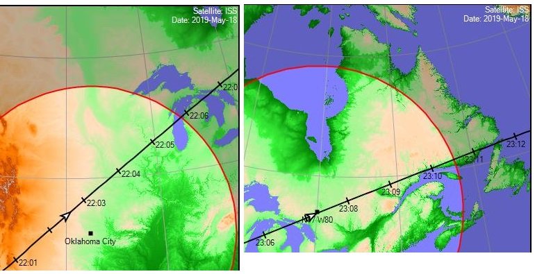
When you go to the Satellite View, most of the time you can see a geographic item near the area at the edge of the view (IE - ISS Track crossing one of the great lakes.) Find a City near that point and search from there to extend the ISS track farther. Another way is to use the Longitude/Latitude lines you see in the SAT View and estimate the next Lon/Lat point. Those lines are 10° apart. Go to the Change my location page and scroll to the bottom. You can change the NAME and the longitude/Latitude. You may also want to change the time zone. On May 18 at 22:02 the ISS will pass OK City at an altitude of 53° to the NW. See left photo. Just after 22:07 it passes over W80° at roughly N47°. Now I change the Location page at the bottom, leaving the top part blank, and change to eastern time, and run the ISS Pass again for the new location. Just after 23:07 the ISS will pass over N47 W80 at max Altitude of 89° to the NNW. See right photo.
-
Month Streak of Waymarks Challenge
8Nuts MotherGoose replied to T0SHEA's topic in General Waymarking Topics
Actually, Waymarking does have it's own Challenge - Lucky 7. Create 7 Waymarks. Each must be from a different Waymark Department. All must be within a radius of 1/2 mile (0.16 KM). http://www.Waymarking.com/cat/details.aspx?f=1&guid=2a0f9fd5-bb3a-49c7-8463-176266b05b2c&st=2 -
Geocaching Race Competitions
8Nuts MotherGoose replied to Forest-Ghost's topic in General geocaching topics
For the Texas Challenge Team competition - each team has no choice of who is on the team. Texas is divided into 6 areas, producing 6 Texas teams, but you can join any of these teams. Anyone who wants to compete has to be allowed on the team of their choice. We also have an Out-of-State Team for all those arriving from other States/Countries. The Out-of-State Team took 2nd place a couple years ago. This is friendly competition, not killer competition. Each year the Texas Challenge is in a different part of Texas. Next year it's in Killeen, TX, midway between Dallas/Fort Worth and Austin. See GC84EA4. -
December ISS sightings
8Nuts MotherGoose replied to vulture1957's topic in General Waymarking Topics
I have only two ISS Passes visible in December from Donna, TX. I use Heavens Above. December 13, 18:57 CST, NW corner of Arizona to the South Tip of Texas. Anything West of Arizona is probably in Daylight. December 24, 06:01 CST, South Tip of Texas to Youngstown, Ohio. Anything East of Ohio is probably in Daylight. -
International Space Station 20 years
8Nuts MotherGoose replied to Max and 99's topic in General Waymarking Topics
My plans to be in San Antonio on Friday evening for the ISS pass have been canceled. I was planning to team up with folks. I've contacted a few people who visit Waymarks in that area. None were interested in creating an ISS pass Waymark with partners. They were more interested i shopping. -
Photo redundancy? A survey.
8Nuts MotherGoose replied to Bon Echo's topic in General Waymarking Topics
When I first started Waymarking in 2006, I was using a 56k modem on a landline. All photos were trimmed and then reduced to ~600 x 800 pixels before I sent them. Now, because I'm on a metered internet system, I still have a habit of reducing my photos to about 1000 x 1200 pixels. I don't think we need to worry about running out of memory. Memory space is probably their lowest cost item now. My newest external hard drive ( 2-years old) is 1TB, and it cost less, and is slightly smaller than my 1GB external hard drive that's a few years older. I've even got a couple 16GB flash drives now that cost me less than $6 each. -
International Space Station 20 years
8Nuts MotherGoose replied to Max and 99's topic in General Waymarking Topics
I will be in San Antonio, TX on the evening of November 23rd. 23 Nov -3.4 18:27:14 10° SW 18:30:27 58° NW 18:32:59 15° NNE visible This is the same pass as Vulture1957 in Oklahoma City. I think you are a few seconds more than 1 minutes from my listed time. So we are good to work together. Kansas City, MO will see the same pass at Max Altitude 52° to the SE as it disappears into the Earths shadow. -
Since we are talking about Seguin, TX. Seguin, TX is the location for GC7JK1C, 17th Annual Texas Challenge and Festival on the weekend of March 9, 2019. I am in charge of getting this Event organized. Groundspeak has reduced the number of Events allowed per day. We were unable to get an Event approved for another Waymarkers Gathering this year. After this weekends Committee Meeting, I will have more information and will write a new Post in this forum.
-
I'll just post visits. No Worries.
-
I got hard rained on while on the bridge taking Then and Now Photos, Benchmark, and River Gauge. 1/2 hour later I took the Rainbow photo as I was leaving town. I was in the old theater earlier in the day. They still have the old carbon-arc movie projector in the loft. I used to have a job operating one when I was in college.
-
Interesting that you were just in Sequin, TX. I was there on Oct 5-6. I took about 150 photos around the courthouse and along the river. I have not had time to do anything with them yet. I just got home on the 15th and now have to make a trip to San Antonio this weekend. While in Seguin I found a few Categories within 500 feet of each other on the river: High Water Marks Hydroelectric Power Station (an antique) Dams River Gauge Benchmark Independent Restaurant Dog Friendly Restaurant Swimming hole Photo Then and Now

-
I think the States representing the most would be for Names starting with THE (84 3x.xxx) and TEAM (83 26.xxx). THE could produce a strip about 10 miles wide, and TEAM would produce a strip only 1 mile wide.

.png)


