


8Nuts MotherGoose
-
Posts
416 -
Joined
-
Last visited
Everything posted by 8Nuts MotherGoose
-
Meeting other Waymarkers
8Nuts MotherGoose replied to bluesnote's topic in General Waymarking Topics
As the Host for that Event, I can share the problems that I had getting it published. Mega Event related side Events have priority. I had to wait until the minimum 2-week Publish limit until I could get the Event approved. By then it had been pushed to 4:00 pm on Sunday. Many folks had to drive home on Sunday to be at their jobs on Monday. The nice thing about the Event was the location was within a 4-square block area with over 100 Waymarks to visit. I also had a Waymarking Booth set up all day during the Mega Event. Several Waymarkers took the opportunity to sit and discuss their favorite subject. I may have done better by having a set time to meet at the booth. Maybe Noon for a lunch get together. -
The peer Review page says until 5/3/2023 2:09:00 PM. I'm not sure which time zone that is.
-
There has been good discussion and some good feedback on some issues. It's now time for a public vote.
-
Not if you go here - https://coord.info/GC9KV5M It is about 6 meters from the N coordinates. There is a large sporting goods store there where you could drool over the new GPS units.
-
ISS partner search or iss seen
8Nuts MotherGoose replied to Ariberna's topic in General Waymarking Topics
Watch your data carefully. It changes over time. This post on Monday shows your pass at 23:52:55 (69° SSO) Five days later, today, it shows your pass at 23:57:50 (72° SSO) What will it be 26 days from now on May 14? As the path of the Pass moves closer to you and your xx° rises, the path is moving away from Alfouine and his xx° is dropping. Will he be below 45°? How much will the Pass change if you are planning a Pass 75 days from now in July? -
need help with ISS SIghting
8Nuts MotherGoose replied to vulture1957's topic in General Waymarking Topics
I think I have found the solution. On April 6, in Edmond, OK., the sunset was at 19:56:xx The ISS Pass was listed as Visible and reached Max height at 20:18:49, 67°. The difference in time between Sunset and Max height was 22 minutes plus a few seconds. After the sun sets, and just before the sun rises, there is a period of time called Twilight, or Dusk. Twilight is 22 minutes long for my area at this time of year. The length of Twilight is a variable. As you get farther North, Twilight will be longer. I suspect the ISS Pass chart considers the Twilight time as Daylight. We had an ISS Pass over Abilene, Texas tonight. Max Height was 16 minutes after Sunset. It was still listed as being in Daylight. My friend in Abilene said he did not see the ISS or any stars in the sky. He did see the Moon and said it appeared hazy like there was a thin layer of high clouds blurring the view. Here is a web site to see the variable length of Twilight vs Latitude vs Time of Year: https://stjerneskinn.com/for-how-long-does-the-twilight-last.htm -
ISS partner search or iss seen
8Nuts MotherGoose replied to Ariberna's topic in General Waymarking Topics
Unfortunately, this Pass has a major flaw also. The Pass enters the Earth's shadow for 4 minutes as it crosses the Atlantic Ocean. When the ISS enters the Earths shadow, that is the end of an observed Pass. When the ISS comes out of the Earths shadow, that is the beginning of a new observed Pass. This photo shows the Pass with the entire 4 minute shadow. The Summerside Pass is inserted into the photo of the Pass viewed from N51.80 W40.00 for your comparison. If this Pass had occurred 2 days later. The sun would have been high enough to keep the ISS in sunlight along the entire Pass.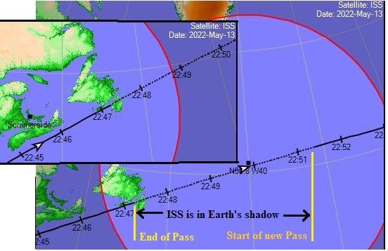
-
need help with ISS SIghting
8Nuts MotherGoose replied to vulture1957's topic in General Waymarking Topics
I don't think Daylight savings time had anything to do with it. That was just coincidental. The charts we look at are adjusted daily by the Powers That Be. When a Pass time gets too close to daylight, it's removed from the Visible Passes section that most of us accept as "written in stone" fact. It goes to the All Passes section. In the All Passes section it still shows as Visible. As adjustments are made the time gets closer to daylight until "visible" is removed, and "Daylight" is put in it's place. These passes are usually only partly visible. If you have your back to the brighter section of the sky, you can still watch for the Pass in the darker portion. It just won't appear as bright. That's why the "Brightness" column is blank in the All Passes. I use the All Passes page to find a partner. I can find a Daylight pass that goes over me at nearly 90°. I can follow it across the Unites States and see what major cities are on that path. I continue to follow it into Canada and make note of cities. Then it crosses the Atlantic and passes over southwest France and northeast Spain, and the "toe" of Italy. I now have cities pin pointed that have 90° passes when I have 90° passes. I compare their visible passes with mine. I now know France and Spain will have visible Passes at 2:00-4:00 am their time, when I have Passes at 9:00-11:00 pm my time. I have a list of cities along the Path to find willing Partners. These cities will always stay the same for every SW to NE pass over my home. A Pass to my North will end in Spain. A Pass to my South will be more France and Italy. -
ISS partner search or iss seen
8Nuts MotherGoose replied to Ariberna's topic in General Waymarking Topics
PART 2 - Finding a Partner for a temporary Location. When you travel to a location away from your home, you also have to find new Partners for your ISS observation. To find a Partner, you have to know what other cities the ISS passes over when it passes over your new location. To find these cities, let's take an imaginary ride on an invisible ISS Pass. Our new location will be Santa Cruz de Tenerife, Canary Islands. The current list only shows two visible Passes. Both are below 45° Altitude. Just above that list there is a choice to make: "Passes to Include: O visible only O all" Click on "all" Now you are seeing the two Visible Passes AND all the invisible Passes. Invisible Passes occur during daylight and at night when the ISS is in the Earth's shadow (unlit). We want to choose a Southwest to Northeast Pass with the Highest ALT number. January 30 with ALT=88° works best. That is an invisible daylight Pass directly overhead. Click on that pass and then look at the Ground Track. Follow the track to the Northeast until it meets the coast of Spain. Look at a map of Spain and we can tell we are near the City of Sevilla. We open another Heavens Above page and change our location to Sevilla, Spain. Once again, View ALL passes and we see on January 30 Sevilla is at 86°. Click on that Pass and go to the Ground Track page. Go to the Northeast end of the path and we are now near the France/ Italy border. You can continue this Path as far as you wish. When searching for Partners along this line, your search can be 350 km perpendicular to and on either side of that path and your partner will still be within the 45° minimum ALT requirement. These distances and ALT ° are only good for this very high pass. The lower your ALT° the closer to the pass line your partner needs to be. Try to find a partner as close to the line as possible. Any Questions - Contact me at 8nuts1@gmail.com -
ISS partner search or iss seen
8Nuts MotherGoose replied to Ariberna's topic in General Waymarking Topics
When you are at home, you have learned that your Southwest to Northeast ISS Passes always pass near Tours, France or Wimille, France. This always gives you partners. When you travel away from home, you have not learned what Town, Country the ISS Path takes you to. You can learn and be prepared before your next trip to the Canary Islands, or any other distant point that you plan to visit. This is a two part process. Part 1 is changing Heavens above to search for passes at your new location. Go to your normal Heavens Above page. At the top left, under Configuration - click on "Change your observing location." Scroll down below the map to "Enter place to search for" and enter a Town, Country. Then hit the Search button. When you know you have the right location, scroll down and hit the UPDATE button. Now you can do your search at the new location. PART 2 will be posted soon. -
Has the Review Waymark page changed?
8Nuts MotherGoose replied to 8Nuts MotherGoose's topic in General Waymarking Topics
Thanks. All is well now. I didn't check the Features and Functions section of this Forum. -
I had the same thing happen to me today and followed Max and 99's advice. I :\"went to the link on the right, of My Categories, and was able to access it there."
-
I opened a Waymark page to review it and there is no Approve/ deny or comment section at the top of the page. All I see is one line at the top of the page that says, "This waymark has not been published by the category group yet." then it shows the Waymark page. I scrolled all the way to the bottom, thinking they may have moved things, but there is nothing at the bottom either.
-
Absent Leaders and Unresponsive Officers
8Nuts MotherGoose replied to wayfrog's topic in General Waymarking Topics
I'm interested and somewhat knowledgeable. -
I live at N26° at the south tip of Texas. I'm 50 miles (80km) from the Gulf of Mexico. We get a cooling breeze off the Gulf and it rarely hits 100° F (38° C.) It will stay just below 100°, about 96 to 99 for weeks. Another 50 miles farther west and it frequently hits 110° F (42° C.) What you folks are experiencing is astonishing.
-
I have about 1000 Found caches on my Garmin 66s. I can't download them into GSAK. I can't download them to show on BaseCamp. What am I missing? Why are they on my GPS? Where are they stored? If I can't do anything with them, why can't I find a way to delete them?
-
In all of my travels, I have driven through several towns that have special art forms spread through out the town. All are identical, but each is decorated differently. I've seen: Mercedes, TX. has Boots. Mission, TX. has Butterflies. Hutto, TX. has Hippos (most are 2' high, but two are full size.) Clinton. IA. has Lighthouses (4' high) Papillion, NE. has Butterfly benches A town in IN. has 3' high Horses. A town in IL. has Lincoln top hats. (3' high) I've also seen Porpoises in a small sea side town. Is there a single Category for all these Special Town Arts?

-
Question for #1 - Are we suppose to publicly post messages from GC Messaging to this forum to prove our point in detail? A person creates a Waymark without following the Category Rules and the Waymark is declined. I receive a message from him accusing that I am one of the group that is trying to get him banned and it was all my fault that he got his Waymark rejected. He then then took the rejected Waymark, changed all the write-up and accused me of doing many things I didn't. He then posted it to the Uncategorized Waymarks where it's available for public viewing. Shortly there after it was removed from that category and put into Alpaca and Llama Farms. Now it says This Waymark has been deleted. WM12TKM.
-
Is there a way to bulk delete Personal Cache Notes?
8Nuts MotherGoose replied to 8Nuts MotherGoose's topic in How do I...?
Thank you, IceColdUK. That's what I was looking for. I knew there had to be something out there but could not find it. I'm just the opposite of you. I keep all my puzzle solving info in GSAK Notes. I want to delete the GC Notes on all the Archived caches. They serve no purpose and I have to set a special filter on Project-GC if I don't want to see them as part of my Solved Puzzles list. -
Is there a way to bulk delete Personal Cache Notes?
8Nuts MotherGoose posted a topic in How do I...?
I have hundreds of puzzle caches solved and coordinates written on the Personal Cache Notes on the cache page. Many I have found and many were archived before I found them. Is there a way to bulk delete these notes? I dread deleting one at a time. I'll be at it for days. If it will help, I use GSAK and I am a Premium Member on Project-GC. -
ISS Sightings July 2020
8Nuts MotherGoose replied to vulture1957's topic in General Waymarking Topics
Nice photos, thank you for sharing. Did you see NEOWISE? (OOPs, I guess I didn't read close enough) I've tried once in the morning and had too much haze/moisture. I've tried each evening but haze seems to cover everything up to about 30°. Even my ISS View didn't appear until about 45° and there were no clouds in the sky. Tonight it's overcast. -
ISS Sightings July 2020
8Nuts MotherGoose replied to vulture1957's topic in General Waymarking Topics
Yes, every two months is best. But September will probably have a shadow between North America and Europe. If you go to Heavens Above and then to the pass list page - in the upper right you see "HOME I INFO I ORBIT I Click on ORBIT. Look at the lower picture showing the entire current pass. When the upper loop of the pass aligns with the night shadow, we have lots of views. The ISS passes move west slightly faster than the night shadow. It will be September when they align again. Right now Europe also has no shadow on the pass in the evening hours. They might be able to catch a pass all the way to Australia for an evening or three. Then the shadow will start to reappear in the pass at the upper part of the loop as it curves downward and a team with Australia will be impossible. -
ISS Sightings July 2020
8Nuts MotherGoose replied to vulture1957's topic in General Waymarking Topics
I'm not going to decline any waymark just for math if the time and speed are shown and the math shows the decimal point in the right position. If it's a 3.5 minute observed pass for 10,500 miles, I'm probably going to decline and ask them to check their math. I have already discovered that we are using the ISS speed for our calculations rather than the Earths ground path speed. The ISS orbit Circumference is 42,650 km The Earth's Circumference is 40,074 km Based upon a 90 minute orbit The ISS Speed is 473.888 km/minute (294.5 miles/minute) The Earth's Ground Track speed is 445.269 km/minute (276.7 miles/ minute) These number are still a rough guess because I only checked for Circumference of each on one web site. -
ISS Sightings July 2020
8Nuts MotherGoose replied to vulture1957's topic in General Waymarking Topics
You measure the distance along the Ground Track by multiplying the elapsed time by the speed. If you search the internet to see how fast the ISS is traveling, you get anything from 17,200 mph to 14,710 mph (4.777 mps to 4.08 mps) 1509.68 miles divide by 5 min 53 sec = 4.2767 miles/sec. That is in the lower half of the speed range. 1679.574 miles divide by 5 min 53 sec = 4.758 miles/ sec. That is in the upper half of the speed range. If we use 293 miles/minute that is listed in the ISS Category instructions - 5.883 min x 293 = 1723.82 miles. That's 4.88 mps which is a bit above the speed range. Having quoted two people above, I will quote a third, my friend, Burger King, "Have it your Way!" Use what works for you. Personally I feel that 293 miles per minutes is too high. When you are using a coordinate checker you are measuring the distance between two points that are not on the flight path. Is the checker measuring a flat earth distance, or is it using a more complex formula for a curved Earth? In the below photo you can see: Red is the ISS Flight Path Black is the portion that two people are watching Blue is the distance between Coordinates of the two observers. You can see how the blue line is longer than the observed black line since it the hypotenuses of a right triangle verses the base. This is why we use the elapsed time multiplied by the speed along the ground path.
-
ISS Sightings July 2020
8Nuts MotherGoose replied to vulture1957's topic in General Waymarking Topics
The rules are vague. Waymarking rules say you can always Visit your own Waymark. ISS Category Rules say when you observe an ISS Pass you can Visit the nearest Waymark created for that Pass. I don't think the author ever considered two or more groups Waymarking the same Pass. I believe the intent was for you to visit the nearest Waymark of your Group. Lets keep it that way. I can see penalties if we impose cross Visits between groups to nearest Waymark. Vulture 1957, through hard work and some good luck, finds a partner in Monaco. He wants no other partners because he wants to Visit Monaco. All goes well and two Waymarks are created. BUT on the same Pass, someone in Chicago pairs with someone in New York and they create Waymarks. Vulture 1957 now has to Visit Chicago instead of Monaco. If there are two groups creating Waymarks on the same Pass. Vulture1957 creates a Waymark but his partner gets clouded out. He can Visit his own Waymark and he can Visit the nearest Waymark created by the other group.

.png)
.png)


