

PFF
-
Posts
1197 -
Joined
-
Last visited
Everything posted by PFF
-
"Accuracy" is a squishy term. It can mean that you are able to find a geocache using a smart phone. However, the only real test is checking against an object with a known set of coordinates. For those of us in this hobby, the most accessible object is a benchmark. While on the data page for a cache, you can click "Nearest Benchmarks" to see if there is one nearby. It must be a benchmark where the horizontal coordinates are "adjusted". Don't use one with horizontal coordinates which are "scaled". (This info is at the top of the benchmark page.) A preferred location is in the open, rather than being in woods or among tall buildings. Hold the GPS device about head level. Let the unit settle for a moment. Then look at the coordinates in real time. A dedicated GPS unit will display the coordinates shown in the data sheet. If you are using a smart phone and one of the coordinates is off by more than one digit, try different operating modes. If it won't "pull in", get a feel for the distance and direction of the error. This can serve as a "fudge factor" which you can apply if you're looking for a cache and just can't find it at GZ as indicated by the phone. Bottom line: Benchmark coordinates are accurate to within an inch or less, making benchmarks an ideal standard for checking your GPS equipment--and your technique. P.S. Since you've visited the benchmark, log it at www.geocaching.com/mark, or use the link on the cache page. It's the same website, so you can use your regular name and password.
-
I carry log sheets and plastic bags. When a log is full, I take the old log with me. I always send a message to the CO, offering to E-Mail the log in a .pdf format, if desired. (Interestingly, I've never had a CO accept my offer.) The only time I will re-hide a cache is if I find it lying on the ground. Rather than taking it away from the site, I hide it in the most likely spot. I mention in my log that the cache may not be in its original location. Then I send an e-mail to the CO describing precisely where I hid the container so the owner can find it and get it back where it belongs. It's interesting to visit the CO's profile page to see the last date that the CO logged into geocaching.com. It can give you a perspective on what maintenance can be expected. One CO disappeared for six months but then logged in two days after I reported doing minor maintenance on two of his hides. There are three caches from a CO in my area which need a new container, or which appear to have gone missing. The owner's last log-in was more than two years ago. I sent a "head's up" e-Mail via the website, but I suspect the individual has left the hobby. If nothing changes, the missing cache eventually will be archived by the area reviewer, and maintenance on the others will be done by good Samaritans--thus keeping the hides available for future hunters. If you change a log sheet on a puzzle cache, be sure to copy any codes which appear on the original.
-
There are better ways to download caches, but I simply create a gpx file for the ones I want to hunt. Then I upload these to MapSource from the "downloads" file on my computer. That creates a map which will transfer to the 60cs. I also print the map because I like a visual representation which is bigger than the screen on the GPS receiver. In addition I can load the dashboard GPS (NUVI) by exporting the MapSource map as a gpx file, using Garmin's POI loader. The dashboard unit gets me to a good parking space and the handheld unit takes me to the cache. Many folks like to have the entire data sheet stored in the GPS unit, and I'll let one of them describe how it's done. I skip that part because I can view the data sheet on my cell phone. But take heart.....with the GPS unit you purchased, downloading info is a pretty seamless operation. The tech folks have made it easy...even for old dawgs.
-
EdrickV brings up an excellent point. Geocaching often is a several-hour activity. Picture yourself needing to make a phone call and the batteries are nearly exhausted from use as a GPS. However, as he points out, you can plug the phone into a charger as you drive from one cache to another. It may not fully re-charge, but it certainly will extend the number of hours you can hunt. And if you stop for lunch, leave the phone in the car with the charging cord connected--assuming you have a 12-Volt outlet which stays "hot". Also, consider purchasing one of those handy little "battery boosters" which contain their own batteries and which can give your phone an emergency charge. (These occasionally are on sale at "The Shack" and at big box stores. Watch the ads in the Sunday newspaper.) The Good News is that with forethought, battery power can be managed wisely, giving you many hours of geocaching fun with your smart phone. -Paul- Side note for Edrick: Regarding accuracy improvement with an external antenna.....On phones like the Tilt, connecting an external antenna will improve cellular reception, but it may, or may not, assist the GPS function. Phones and GPS operate on different radio frequencies, so the GPS chip may be hard-wired to an internal antenna. Also, an amplified antenna gets its operating voltage from the host device, which slightly increases the battery drain and shortens the operating time. (The newest smart phones do not have an antenna port, making this a non-issue.)
-
Of COURSE you can geocache with a smart phone. Read my post. That's why geocaching.com has an APP. And you can place a cache using a smart phone, or a $99 GPS, or a top of the line model. But whatever device you use, take a moment to look at the satellite view in the dynamic map or try putting your coordinates into GoogleEarth to see if the position plots reasonably close to where you hid the container. If you are one of those who feels that precise coordinates are a spoiler, fine. Be 30 feet off. But monitor the logs for your cache and at the first sign that you are putting people in dangerous or uncomfortable situations, move the coordinates 30 feet in a different direction.
-
I've taken a 2-step approach to evaluating smart phone accuracy. In my area (Raleigh NC), caches set with smart phones are approximately 24 feet off. Usually the cache is south and slightly west of where the coordinates point. Sometimes it is 22 feet east or west. The statistics were compiled from 25 caches where the container was hidden in a place significantly different from where the dynamic map showed. Coordinates were taken at the cache using a 60Cs checked against government benchmarks, and a computer program was used to calculate the bearing and distance of the error. Step 2 involved reading all the logs of over 75 caches--including those found at the location shown on the dynamic map and those which were not. Two patterns emerged. If the cache was at the correct location, finders sometimes complained that the coordinates were off, or that they put the user in the middle of a parking lot, etc. These appear to be from smart phone users. If the cache was not at the correct location, there also were complaints--but these were from experienced cachers who are known to have dedicated GPS devices. Is a 20-30 foot variance acceptable? Yes, if you are looking for a large cache, or one where there are a limited number of hosts. But, when looking for a micro in the woods, it creates a challenging situation. It also can cause harm. If poor coordinates cause people to wander into areas of sensitive vegetation, geocaching could be banned in parks. I found some cases where poor coordinates put people in potentially dangerous situations--such as at the edge of high retaining walls. One trail-side cache's coordinates took hunters 40 feet into the woods, right to a yellow jacket nest. Over several weeks, numerous people were stung--some several times. (Eventually, the CO was persuaded to adopt the alternate coordinates posted by the FTF, and life got better for everyone! May I add another reason why I'm concerned about folks who do not understand the accuracy limitations of smart phone GPS technology? If you read this forum on a regular basis, you frequently see posts from new hunters who are discouraged and are ready to quit. The primary reason? Going after 4 to 15 caches and not having a single find. Each time such a post appears, people respond with the usual helpful suggestions about looking for a cache which has been found recently and which has an easy rating, along with the recommended team approach. But nobody ever suggests that the lack of finds may be due to the quality of equipment used in the hunt; used to hide the cache; or both. Bottom line: If you can afford to purchase a stand-alone GPS, do so. Even the most expensive ones beat a smart phone, unless conditions are absolutely perfect and you're not a hurry (and can wait 5 minutes for the phone to stabilize). And how many caches have perfect conditions? Very few! Smart phones can be an excellent entry path into the hobby. That's why geocaching.com has an app. Just remember that the accuracy of the phone's GPS is less than stellar. But it's also true that with most caches, the GPS gets you close to GZ, and then you shift to the "geo-sense" mode.
-
Glad to see that our group's hard work has made it to the data base, where it can be used by professionals. They don't do anyone any good sitting in the "inbox". Thanks for monitoring and for providing the updates. -Paul-
-
There has been grave concern over the proposed establishment of a nationwide wireless broadband network consisting of up to forty thousand high-powered transmitters operating immediately next to the spectrum allocation for GPS satellites. After a outpouring of criticism from GPS manufacturers, the Coast Guard, the FAA, plus many police/fire organizations, the Government mandated testing to determine the extent of interference LightSquared's operation would cause. The tests were conclusive. As any Ham Radio operator could have predicted, interference with GPS technology (i.e.; receiving weak signals from space) was a certainty. [is there NO ONE remaining at the FCC who has any actual experience with radio communications?) LightSquared initial position was that GPS manufacturers would "just have to do a better job designing receivers". That idea did not fly very far! Not only is it an impossible task, but what about the millions of receivers already in use around the World? Facing strong and increasing resistance, LightSquared has agreed to move some of its operations to another frequency and to reduce operating power. Most importantly, LightSquared will not be allowed to begin operation until the interference issue is resolved. Meetings with GPS user groups are continuing at this time. Article at: http://wraltechwire....ogpost/9753070/ -Paul- Celebrating 50 years as a licensed Amateur Radio operator (June 16, 1961)
-
Hi Cardinal Red, That's a great tip about switching to YARDS. Thanks! I walk a lot of property lines, and this will be very valuable. I'm eager to give it a try. You brought up a good point about whether this Canadian parcel is expressed in Yards, rather than Feet. I enlarged the diagram and the mark after the distance appeared to be a single apostrophe, which I took to mean "feet". Also, the map scale appears to be "one inch equals 400 feet". I relied upon the relative size of Parcel #17, as well as the width of the Interstate Highway, both of which seem consistent with "feet'. However, I could be wrong. I do not have experience with plat maps from Canada, so the the concept of the map being in "yards" did not occur to me. I'm glad you mentioned it so I can be more alert to this possibility. In the U.S., I would expect to find feet, most of the time--although the common unit of measure in NGS data sheets (such as describing benchmarks) is Meters. Oddly, there is only one value for the Meter, but there are two kinds of Feet--a linear foot, and a survey foot. Fortunately, there isn't enough difference to loose sleep over. [Grin.] For a full discussion, visit this FAQ and scroll down to a long section where the font looks like it was written on a typewriter. Thanks for your interesting comments about True North. Since Magnetic North moves, it would seem logical to convert to True North for consistency over long periods of time. In the late 1800s and early 1900s, the US Government established "meridian" stones in centralized places. A Meridian Station consisted of two granite blocks (each weighing about 600 pounds), placed approximately 100 feet apart in a True north-south line. A surveyor was required to visit his county's meridian once per year to calibrate his compass. The surveyor then recorded the correction in a special book in the office of the Register of Deeds, and paid a fee of $5.00--which was a significant business expense in 1900! A logical assumption would be that if a survey were based upon magnetic north, a notation would be made giving the declination for the year in which the survey was done. I hang out with some professional surveyors, and I intend to ask about these topics. I'll let you know what I find out. Best regards, -Paul-
-
Hi John, I agree with the explanations given earlier. While the answer is not what you were hoping for (i.e., a set of coordinates), your GPS receiver still can be helpful in finding your property corners. METHOD ONE: If you can find a known point (typically an iron pipe driven into the ground), you can create a waypoint. Then, you can travel outward, following the bearing on the map, until you get to the distance indicated on the line. Ideally, this would put you within 12 to 16 feet of the next boundary marker. METHOD TWO: Find a known point and use the "Project a Waypoint" feature, if your GPS has it. Caution: This might require reading the instruction manual. As you know, that's not really a "guy" thing to do. Run the line immediately after creating the waypoint, so that any error caused by satellite positions is consistent. (Don't create the waypoint on Tuesday and run the line on Wednesday.) Converting surveyor terminology into bearings which can be used with your GPS: The first compass indication is the starting point, and the ending indicator tells you which way to go around the dial. In your example, N 87 E does not take much thought. Start at North and go toward East for 87 degrees. Yes, the bearing actually IS 87 degrees. If the first indication had been South and the second one East, you would start at South and move counter-clockwise toward east for 87 degrees. Since South is the 180 degree mark, subtract 87 from 180. The answer is 93 degrees. That's the bearing for the GPS. Technically, the answer is not that clean, since there are fractions of a degree. However, the accuracy of the GPS unit is not good enough to worry about it. If the indication had been North 87 West, you would begin at North (360 degrees) and move toward West for 87 degrees, putting you at 273 degrees. You would expect such a line to be running almost exactly East-West. And for this next revelation, I hope you are sitting down! A line on a survey which is described as North 87 West could also be described as South 87 East. To visualize this, draw a circle and label the N, S, E, and W points. The only downside to these methods comes when the line segment is longer than 520 feet. That's where your GPS will switch from "feet" to "decimal miles". The good news is that you can convert something like 725 feet into decimal miles with a calculator. The bad news is that the GPS will get you close, but then (as with a geocache), you have to use your eyes--and sometimes a metal detector--to find the iron pipe. Are there ever "real" latitude/longitude coordinates on a surveyor's plat? Not in the format you are expecting. However, you sometimes will see a reference point which contains a number named "northing" and another named "easting". (Or, the surveyor may have used "X" and "Y", which is the same thing). These are SPC, or State Plane Coordinates. There is an on-line computer program which can convert these coordinates into latitude and longitude, but it's pretty complex. If you encounter SPC, hop over to the benchmarking forum (www.geocaching.com/mark) and open a thread asking for help. The Forums are monitored by some professional surveyors, as well as representatives from the National Geodetic Survey--including the fellow who wrote this article. (Yes, this is the same Dave Doyle who is interviewed in the History Channel's program, "How the States Got Their Shapes". ) Meanwhile, if the referenced object is a benchmark, someone in that forum probably can come up with the latitude and longitude simply by consulting one of several data banks. I hope this is helpful. If you practice the art of projecting waypoints, and you'll grasp it pretty quickly--despite the "quirky" terminology used by surveyors. . -Paul-
-
The following has been submitted on EBay's feedback page: http://myworld.ebay.com/sirmarkw/?_trksid=p4340.l2559 This item was misrepresented in its advertising. It is nothing more than a Reference Mark disk intended to point to a main survey disk no more than 0.6 mile distant. It did NOT point the way to Washington DC. Moreover, the Seller copied all of his information, word-for-word, from Wikipedia's "Espionage" article. Please do not allow the sale of Government survey markers. It encourages people to steal these objects--which were placed at great expense to Taxpayers.
-
If one of those was GC1CSV4, a reading of the logs (even just the most recent ones) would have alerted you that the coordinates were significantly inaccurate. Hence, going to the published coordinates was not going to get you "right on top" of the cache. On the other hand, this would have worked well at GC17XT7 and GC2K8CO, where you reported the coordinates as being "very good".
-
That might be a good solution if the object of the game was to see you close you can get to a set of published coordinates. The object of geocaching is to find geocaches. Considering that the accuracy of the GPS device used to capture those coordinates might be off as much as 25-30 feet, even under optimal conditions you might navigate to a location that is still 25-30 from the target. You might even find that your GPS is showing the exact same coordinates and then look up to see a large tree with a hole in it 20 feet away where the container is actually hidden. Use the GPS to get "close" then use your eyes and other senses to locate the cache. 1. If you read the last line of my post, you will see that I said the same thing: Get close, then use your eyes, your instinct, and your imagination. 2. Elsewhere in this thread, it is wisely recommended that newcomers read the logs before setting out. If the coordinates are as far off as in your example, it is likely that several logs will contain comments about the inaccuracy. 3. The suggestion about viewing the coordinates is the result of reading hundreds of logs which state that the pointer was "flopping all over the place". Comments like this frequently appear in "Not Found" logs. The "edge", or advantage, is that the coordinate reading is more stable than the pointer. I'm not saying the coordinate method is perfect, but it's much less distracting! 4. You point out that "The object of geocaching is to find geocaches." I agree, completely. Remember, this thread is in "Getting Started" and the Original Poster was extremely frustrated by NOT finding geocaches. I can see how after continued disappointment, one might give up, thus missing out on what could have been a very enjoyable hobby. I've been very impressed with the helpful suggestions which have been submitted, and I hope these encourage many newcomers to stay in the game. Best regards, -Paul-
-
Good news! Thanks to assistance from our always friendly and knowledgable Forum participants, MsAsh+Kevo successfully logged the three benchmarks referenced in the original post. And the log entries look great. (They even have the correct recovery date, even though the log was created three weeks afterward.) It is wonderful to observe the consistently patient and detailed assistance given in response to questions from newcomers to the hobby. When speaking to groups, I often use this website as an example of how the Internet really can be a nice place, if folks are willing to make the effort. Even if I did not give a hoot about benchmarks, I'd hang out here, just because of the people. Any aspect of the hobby can be frustrating to a novice. In fact, there is a Geocaching Forum called "Getting Started" where you find threads with titles like "So disappointed and frustrated..." As I was looking through the entries, recently, I was pleased to see some very familiar names--the same benchmark hunters who help newcomers with disk identification and logging. Yes, Virginia, there ARE nice people in the World! -Paul-
-
Here's a "deep dark secret" to give you an unfair advantage. Follow the GPS unit's "pointer" until you are close. At some point near Ground Zero, you may find the pointer suddenly flips to the opposite direction--as if you were 18 feet east of the target one minute, and now are suddenly 18 feet west. (There are technical reasons why this happens, including signal reflection from nearby objects, or a weak signal caused by terrain or tree cover.) The solution is to switch the view from "pointer" to "coordinates". Move around slowly until the coordinates on the screen match those published by the cache owner. The coordinate reading will be quite stable, and you will be within a couple of feet of the target. I've used this technique to locate thousands of benchmarks, and recently I tested it with several geocaches. Adjust one direction at a time; i.e., N-S, and then E-W. Once you are at -GZ-, use your eyes and your intuition--and, in many instances, your imagination! Happy hunting! -Paul-
-
I don't think I want to give the OP any further information without a better understanding of the situation. Good point, Bill. It appears that the OP registered for this website specifically for the purpose of asking his question. And like you, I wondered about the significant difference in coordinates for what is claimed is a single parcel of land. -Paul-
-
There are computer programs which will do the conversion. However, you must know the numeric "factor" for your location to plug into the formula. The factors are published for the United States, where the format is referred to as State Plane Coordinates. However, your post suggests that you are not in the United States. One of our Forum participants, Dave Doyle, is our resident expert in SPC. Click here for a magazine article on the subject, which he wrote for professional surveyors. Best regards, -Paul-
-
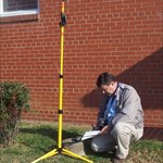
Sounds like an interesting read--especially since I was a professional telegrapher for over a decade. The invention of the telegraph ushered in an age of accurate weather forecasting by allowing simultaneous reporting of weather conditions over a wide area. Obviously, it provided increased accuracy in the surveying profession, as well. The photo below shows a plaque at a Longitude Station (EZ5145) on the grounds of the North Carolina Capital building in Raleigh. Click here for lots of photos of the station. Notes in the original description and recoveries indicate that no one responsible for caring for the Capital grounds knew what the large stones were for. -Paul-
-
Actually, people's replies are more accurate than they realize. The markers described by the original poster (and illustrated by DifficultRun) are NOT right-of-way markers. They are a common indicator of an underground utility line--water, in this case. These may, or may not, be within the right-of-way corrider. Often, an easement (just outside the R/W) is granted to water, sewer, cable, telephone and electrical providers. Sometimes the easement is for other purposes, such as "sight" or "slope". Once such case was EZ6551. On the other hand, the monuments enscribed RW or R / W which BasicPoke mentions having seen in Oklahoma ARE right-of-way indicators--and such are pretty common in other states, as well. It gets interesting when a survey crew incorporates a R/W marker into a station, as happened at EZ1102. See the picture below (looking near the center of the monument for the survey point), or click here for the description, plus a recovery report with additional photos. -Paul-
-
Hi Bobby, BasicPoke is correct. This is part of the county-wide water system. The initials stand for "Master Valve". Best regards, -PFF- Raleigh/Cary
-
In my area, azimuth marks usually are beside a road. Using a protractor, draw a line outward from the main station at the described bearing. Where it crosses the described road is where the mark will be. You can use the pointer in Google Maps or Google Earth to get the Lat/Long. Enter the position into your GPS receiver, and you won't have to worry about the odometer. If you pay attention to which side of the road is mentioned in the description, you'll be amazed at how close the GPS will get you! -Paul-
-
I'm glad the question has come up, because I have struggled with the same issue. Sometimes I submit a complete report to NGS but I omit directions or GPS readings in the Geocaching.com report. Other times, I include a remark that the station is not appropriate for recreational recovery, and I give the reason. The third option is rare, but I occasionally write a note instead of a recovery report on Geocaching.com and flatly state, "Forget it". -Paul-
-
Thanks! And I've taken note of your excellent disclaimer. Your lawyer is worth whatever you paid him! -Paul-
-
I see my new counties in Virginia and one new county in North Carolina. NC is about 90% filled in. The remaining counties are a long way from the major urban areas, so we may have to wait until vacation time rolls around and perhaps we can get some help from our visitors. (Hint, hint.) -Paul-
-
How many points can you add to a Nuvi? I use the NUVI POI DOWNLOADER, but have never tried loading more than 40 points for a project. More would be better--especially with the "alert" feature. Also, clue me in about the datasheets. I had no idea that this might be possible! (I use an older model Nuvi 250.) -Paul-