

wildlifewriter
-
Posts
694 -
Joined
-
Last visited
Posts posted by wildlifewriter
-
-
Well if no-one else responds I'm up for it. Now that I have got rid of the man flu that is.
I agree that the bold Yotter would be just the fella for this.
I was interviewed by BBC Radio Ulster last year, in similar vein. (Below, with BBC's Jim Kelso)
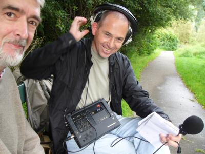
For copyright reasons, a copy of that piece isn't available on the web. (Not on my site, anyway.
 ) but I used to have a recording of it, somewhere at home...
-Wlw
-
Thanks... but I was hoping for input from a local cacher with experience finding caches in the area.
I am that local cacher.

Having done most (if not all) the caches near the top end of Dino's search list, I can honestly assert that there ain't a duff one among 'em. However... you mentioned "quick and fun" - and most of these would involve a fifteen- or twenty-minute stroll to find.
Of those within 5 miles of Crossgar, Ballydyan is undoubtedly the pick - even though it's a micro!
Any other queries on Norn Iron caching (or other activities), the suggestion about posting on the GeoX forum is a good one.
Good luck,
-Wlw
-
This news causes me great personal distress.
Earlier this year, I enjoyed a brilliant day's caching in Scotland with Ewan, and we got on like a house on fire.
I can only hope that his condition improves, to any degree, and that some kind of recovery may be possible. There's little else that can usefully be said, as of now.
-Wlw
-
We are currently planning a trip to Northern Ireland, and this new TB hotel is likely to encourage us to bring more over there. In fact when I did a search last week I was surprised there wasn't any TB hotels there already.
Back at the topic, I can explain the reason for that...
Local cachers here have discussed the possibility of a TB Hotel several times in the last two years. On each occasion, the idea was shelved - mainly because of the very stringent security measures in place for Belfast International Airport.
There are only two major roads giving access to the airport campus. All surrounding minor roads were closed and blocked off years ago. The idea of a visiting cacher trying to find a nearby TB hotel, suddenly finding themselves looking into blinding lights while a voice orders then to remain still and keep their hands in sight, is not one that we could contemplate with equanimity.
None of this affects the "new" cache - it's more than 20Km from the Airport, by road, and isn't near a major city.
Not a problem then - but not really an Airport TB hotel, either.
-Wlw
-
Still doing this? Good...
Garmin eTrex Vista 1
Garmin iQue 3600 1
Interesting stats, so far.

-Wlw
-
Why have you not complained to Garmin that your GPS doesn't locate any caches?
Bullseye...

-Wlw
-
Galileo has been called "the common agricultural policy of the skies", and I certainly wouldn't hold your breath waiting for it. Is EGNOS "fully" live yet? Even if it is, how many years did it overrun - for two satellites?
Coming up on three years behind schedule now, massively over budget and still not working properly.
Still, the EGNOS experience gives us a good way of forecasting how GALILEO will go...
Implementation date: 2010
Budget: Eur 3,250,000,000
So that'll be....
Implementation: 2013 (but probably even later.)
Cost: Eur 7,500,000,000 (and counting.)
-Wlw -
That makes sense, thanks.
How do I convert?
The best way is to use the portal at Nearby.org.uk
Instead of having to convert co-ordinate formats, and then type commas and colons for Streetmap to understand, you just copy-'n-paste co-ords from the cache page into Nearby.
It will understand this format, and give you a whole selection of online mapping and other facilities to select from - one of which is Streetmap.co.uk.
Nearby.org.uk is brilliant - we'd be lost without it. (Literally)

-Wlw
-
I would love to hear from anyone in the Falkirk area who organises or takes part in geo-caching, as a possible feature idea for the local paper.
Please get in touch if you fancy an informal chat
Thanks
A large majority of Scottish cachers hang out at the Geo-X discussion forum.
If you post there (registration required) you'll be in touch with most of the leading geocaching figures in the region - including Dave HH, who did an interview for BBC Radio Scotland last year.
Hth,
-Wlw
-
You Metroguide Europe 7 will display correctly on a Legend Cx
As you already realise, it won't be able to "find address/route-to" on the unit, but everything else will work OK. The road mapping is exactly the same as City Select Eur7.
So you are right - if you don't need auto-routing, why pay for it?
-Wlw
-
I didn't know you could do that - I'll get round to reading the manual one day...

Heavens - where would we be if people read the manuals?

Enter a waypoint in in the usual way, then go into "SETTINGS"*, change the location format to "British Grid" and the datum to "OSGB", then back to the waypoint page and read off the grid ref.
Don't forget to put everything back the way it was, after.
-Wlw
* - or, SETUP or whatever.
-
Just a quick query, is there an easy way of converting WGS84 datum to British Grid co-ordinates in the field?
Why not use your GPSr to do it? (If you're taking it with you.)
-Wlw
-
Well, only as far as you will see the map on the screen. But I want you to be aware that the unit will not be able to calculte on road routes.
I believe you are wrong about this.
The Vista Cx (mentioned OP) has full auto-routing capabilities.
-Wlw
-
OK, yes CN will load into Vista CX. Still looking for the code issue.
There is no issue. See the Cartography FAQ on Garmin's own website.
-Wlw
-
I quite liked the look of the Etrex Vista Cx
What mapping software would I need to buy on top of the unit?
(assuming I want to keep to "official" Garmin software)
There is no reason that City Navigator V7 would not work on a VistaCx. However, I haven't heard of it being done. Other Streetpilots use a different type of mapping (NT) and this is NOT compatible.
Right now, I suggest that you wait for a few weeks. A new version of Garmin's mapping (CNEurV8) has just been introduced (Link) so you may want to get this as an upgrade, first. After getting it, you would still be entitled to an additional (free) unlock on a second unit.
Is there a unit I could "overlay" ordnance survey maps?That would be my preferred display
You can't "overlay" OS maps on a Garmin mapped display. (And the result would look very strange.) There are certain PDAs which can run EITHER routable mapping or OS-based maps - not at the same time - but it all starts to get very complicated (and expensive) at that point.
-Wlw
-
I can't imagine Garmin have made mapping software like this that does not show paths on their devices, so I was wondering if anybody else has encountered this...
It may be a compatibility issue, rather than a problem with the new mapping. If so, it's likely that there's a firmware revision already available for your 60C, which will cure this.
You should contact Garmin UK on 01794-519944 or 0870-8501242
-Wlw
[edited for alternate number]
-
does any body know of a web site that might be usefull for planning a caching holiday in southern ireland.we are spoilt here with memory map.i have posed this question before and had some answers that we tried but the maps were not very detailed.if i could find a leprechaun when we get there that might be usefull.patandjeff and we can take the corgies=bones1.
There is nothing even roughly equivalent to Memory Map for Ireland. Online OS maps are not available for Ireland (apart from NI)
The best web mapping is at Maporama, which uses the most up-to-date Navteq road maps available. These are not fully detailed, but they're better than nothing. (And better than Garmin's current product, as well.)
For motoring, the best nav product for visitors is still this one.
None of these maps can be used to find leprechauns.
Hth,
-Wlw
-
Opinion
No I have noticed it with the Coords of my house, Sometimes it moves up to 100m from where it is
I can't comment on the location of your house, but the statement I made (related to geocaches) is still correct.
Jeremy's name for it is "obfuscation"...
-Wlw
-
I think that GE just moves one as there are 2, but I have noticed also that points can move slightly everytime you open GE
It's done by geocaching.com, to make the location of TBs "fuzzy".
This - and other measures - have been taken to stop smart-alecs like me finding caches (containing TBs) before they're even listed.

-Wlw
-
Well, no, it was Dartford heath I was refering to, but I just checked a TB that has been to Shorne Wood, and it too has two completely different locations, both suoposedly the cache location.
OK - I thought you were referring to a certain TB which was in the cache when you moved it a short distance.
That apart, Craig's explanation above is the correct one.
-Wlw
-
When using GE to track a TB's path, why does it sometimes give 2 'stops' when there should only be one.
This would be at your Shorne Wood cache, right?
-Wlw
-
You mention the varience from the co-ords and the pictures varying from spot to spot. Something I have noticed a few times is that checking/unchecking the 'Terrain' box to make the map 3D can somewhat distort the view looking straight down, with some areas looking either pinced or punched, and surrounding areas being stretched or squshed due to the deformation. I presume to get the most 'accurate' (i use this word carefully in this forum) view, this should be unchecked. Please correct me if I'm wrong.
There's a short answer to this, and also an almost unbelieveably long and boring answer which no-one in their right mind would want to read.
The short answer is that that it makes no difference.
-Wlw
-
Huh?
Surely, the indicated figure of accuracy IS an indication of accuracy?!
Strictly speaking, it's not. The number shown is an estimate of the probability that the position shown will be found within a certain distance. This calculation takes a number of different factors into account. Where the receiver actually IS, is not one of them.
The Forester is right - but he's also being unnecessarily pedantic.
For practical purposes, the figure is a useful guide to how the unit is behaving - and "accuracy" is a useful word to describe it, since any alternative word would cause more confusion than otherwise.
-Wlw
[Edited for accuracy]
-
Just wondering if Cache Nav or cachemate has a way of accessing driving maps I guess.
That's the reason why I mentioned the plugin.
On an iQue, this enables Cachemate to export all, some, or any of the caches in its database, to the iQue waypoint list.
These then appear on the mapping (as a "geocache" symbol, even) and can be routed to using the Que software's own facilities and settings. (It will normally route to the nearest point on the road - this may or may not be a suitable parking place.)
-Wlw


OS maps and paperless caching for gpsmap 60CSx
in United Kingdom and Ireland
Posted
Answers:-
Maps: Pharisee is correct above - you can't obtain OS landranger maps for the 60CSx. Garmin's own 'Topo GB' product is a substitute, but has a number of weaknesses and is ferociously expensive for what it is.
The reason you haven't seen many 'aftermarket' mapping products for the 60CSx is that it uses a proprietary map format. (There is no industry standard for electronic mapping, more's the pity.) As supplied, the unit comes with a 'basemap' which is, er... basic.
Detailed, street-level mapping can be bought from Garmin (City Navigator), but get it on DVD, not on a card.
Memory: A 128Mb card would probably store all of GB street mapping, but it's a tight squeeze these days. Suggest 256Mb as a minimum, 512 even better.
Paperless caching: The 60CSx has some facilities for this. From a GC.com cache page, you can send the info direct to a GPS (if it's connected to a PC), and this will set the cache icon correctly, load the co-ords and should include the hint. It is not a substitute for a printout of the whole cache page, which can be a problem with complex multis or puzzle caches that need the extra info.
Many experienced cachers (and myself) use a handheld GPS like the 60CSx, for on-the ground navigation, and a cheap-'n'-cheerful PDA or old palm device (you can pick e'em up for next to nowt on eBay) to store an offline database of cache info using applications like GSAK or Cachemate. (Google these to see how they work.)
Hope this helps,
-Wlw