

hoyshnin
-
Posts
231 -
Joined
-
Last visited
Posts posted by hoyshnin
-
-
I got the email too.
-
As others have said, you can geocache pretty effectively with a garmin nuvi. For details, READ THIS WEBSITE! - http://geocaching.totaltechworld.com/
-
Not sure, but the BEST way to cache with a nuvi is explained here - http://geocaching.totaltechworld.com/
-
From what I understand, the other MASSIVE difference is the mapping capabilities (what the Pn-40 is probably known most for). The Pn-40 is able to load satellite imagery (think google maps on your gps) and loads of other map types. The GC, though, I believe only has topo maps available.
-
As the others have posted, unfortunately there is NOTHING out there that does both fantastic vehicle navigation AND fantastic off road hiking navigation (usually b/c it is not waterproof, shockproof, etc). The closest thing is probably a Nuvi 500 (unless it's been replaced with a newer model?) which is kind of a beefed up nuvi.
Your best choice is to grab a $100 nuvi for road use and a handheld of your choice for offroad.
-
I already did, see above.
-
Just pulled the trigger on a 32GB, $27.21 shipped. Thanks guys!
Could you please provide a link for that seller, please? Thanks.
Sure, the seller is here - http://shop.ebay.com/love4.lv/m.html?_nkw=...p;_trksid=p3686
BUT, unfortunately he/she was only selling 1 card. Maybe you could contact them and see if they have any more in stock? There are other 32GB cards on ebay for close to that price but the sellers haven't sold very much or don't have great feedback. Keep watching though because they pop up for that cheap pretty often.
I just search for 32gb sd and sort by lowest price+shipping, buy it now, and minimum price of $15 (to weed out all the adapters and such that pop up). Good Luck!
-
Just pulled the trigger on a 32GB, $27.21 shipped. Thanks guys!
-
What price are you finding the 32GB for and where?
eBay, from reputable sellers (those with very high feedback). I'm finding 16gb class 6 sd cards for around $20 and 32gb class 6 sd cards for around $26.50.
-
Just $7 more for twice the gig! That's a no-brainer. You can never have too much memory.
I guess that's my question, is it even POSSIBLE to really use over 16GBs? I just don't know. Suppose I wanted aerials of all the western states, would that be over 16GBs? I just have no idea how much memory the cut maps use up.
Aerials of the whole western US would be WAY over 32GB. I don't even have all of NY (imagery & 24K topos) and I'm between 30 & 40 GB.
Yes, you could definitely use all 32GB - but that'd be a lot of caching territory for a single trip.
Maybe it's easy to swap maps in and out, I don't know, but it would be nice to just load aerials for everywhere within X miles of home and the never have to worry about re-cutting and loading maps again except for vacations or something.
-
Just $7 more for twice the gig! That's a no-brainer. You can never have too much memory.
I guess that's my question, is it even POSSIBLE to really use over 16GBs? I just don't know. Suppose I wanted aerials of all the western states, would that be over 16GBs? I just have no idea how much memory the cut maps use up.
-
So I'll be getting a Pn-40 soon and I'm trying to figure out whether I should get a 16GB or 32GB SD card to go with it. I can get the 32GB for only $7 or so more than the 16GB, but if it's never even possible to get near 16GBs even with oodles of maps, then it's probably not worth springing the extra 7 bones.
So Pn-xx owners, what size is your SD card and how much space have you ever, or would you ever, conceivably use on an SD card? Is the 32GB worth it?
-
Although I registered in 2008, I just started Geocaching about a month ago. On Fathers Day my kids asked what I wanted to do, so of course I said Geocache. We took quite a hike into the woods (which turned out to be about as out of the way as we could have gone), but found this most unusual cache. This was the 10th cache I've ever found and don't know how soon a more unusual one will top it. There are 2 Sharpie pens inside so the animals don't eat them, and you sign your name on the dish.
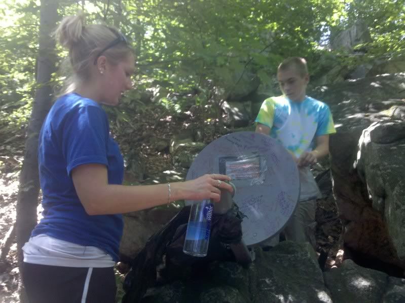
I hope it was on private land, otherwise it just looks like litter with graffiti on it. Neat idea...for placing on private property.
-
Funny you should mention aerial imagery. I was just thinking of dropping Phil a question about that.
If you dig into the docs for his Topo Maps program, you find a small "file server" that lets you upload and download data -- you can use this to send waypoint/GPX files -- or copy your USGS topo quads to and from your own computer instead of downloading from his. The map files are PTM format.
I also note he has a different app for the UK... http://appshopper.com/navigation/uk-map-2 ... I have a feeling the core is the same app, just different data download sources.
So... if his program is simply a download and viewing engine, then all you're really looking for is a new data source -- or a way to make/load the file yourself -- right?
Hm, maybe so. But if you could upload new data sources then that data source would have to be aerial imagery WITH gps information in it so that you could input/view coordinates on the aerial imagery. And I've never seen something like that on an iphone/ipod touch.
-
My favorite (of the moment, it changes constantly) is an iPhone app for loading USGS Topo Quads:
Wow! That's cool! I've got a credit for the iTunes store that's been burning a hole in my pocket...just might need to add this to my arsenal!
I've been waiting for something like this to come out with aerial imagery. Specifically, I'd like an app that 1) shows aerial imagery, and 2) allows you to input coordinates/show coordinates (like this app seems to do).
Unfortunately, I don't think that app exists yet.
-
So I guess Premium membership is required huh? Well--it's papercaching for me then.
Premium membership is required to download pocket queries which you would then shoot to your gps through GSAK. It's only $30 a year or $10 for 3 months. I would highly suggest you try out a membership, even just the $10 one. That's not too much and paperless caching is delicious.
-
DeLorme's GPX processor in the PN-series can't (currently) digest a GC.com GPX file correctly.
A few options:
1) Use DeLorme's Cache Register tool to download it. This will re-format/correct the GPX file to let it show waypoints properly.
2) Use GSAK - it has a macro to do the same required fix-ups.
3) Run the downloaded GPX file through DeLormer's Topo 8 program first.
4) Wait (a few days, maybe a little longer) until DeLorme releases firmware 2.8. This is supposed to fix the problem you're having also.
See also: http://forum.delorme.com/viewtopic.php?f=131&t=24930
Could it be the GPX 1.1 vs. GPX 1.0 issue?
-
I don't know because I'm not a pn-40 owner YET (hopefully will be soon), but I do know that many find this webpage helpful - http://delormepn40.wikispaces.com/
-
Alternatively, you can search by typing site:forums.Groundspeak.com xxxxx where x is the word(s) you want to search.
-
Sheesh. I'm not faulting Groundspeak for not having an update ready to roll. Other apps are working with multi-tasking "as is" and I'd hoped GC would, too.
The only apps that will work are the ones that have been compiled with the 4.0 SDK. Until Groundspeak does that and submits it to Apple it won't work. Its on the app developers to compile the apps and submit them, not Apple.
+1 There are actually only 30 or 40 apps right now that I know of that are 4.0 ready and thus able to effectively multitask, and those ones work great! Give Groundspeak a little time and I'm sure they'll roll an update out.
-
Go to the mainscreen and push and hold the green signal bars in the upper left hand corner for about 5-10 seconds. Also, google "paperless nuvi" and click on the first result for lots of good info.
-
Ive seen a similar cache which stipulated that everyone who finds it may log it as an FTF. It seemed to be pretty popular.
-
And I assume you're familiar with this? http://geocaching.totaltechworld.com/
-
try posting in the gps and technology forum
earthmade pn-40
in GPS technology and devices
Posted
The pn-40 is very accurate, so it is a great choice.