


Nighthawk700
-
Posts
135 -
Joined
-
Last visited
Posts posted by Nighthawk700
-
-
Does anyone know how the "locked in" number are assigned? When I went to the page to get my achiever icon, I did it at the same time (+/- about 5 seconds) as my wife and 3 kids (each of which have their own GC account). We figured we'd get sequential numbers, or as close to it as possible. Instead, all of us got the SAME locked in number! Strange...
-
Oy, this broke all of my filters for logs, new listings, etc. I'll wait for a few more notifications to see what they'll all look like now to build new filters, but wish there was some more advance notice this was coming down the pipe. And if there are more changes implied, that may muck up the new filters I develop. I'm not saying not to change/improve/etc., but giving some feedback on the (unintended) affects of the changes.
-
I would love to see a favorite point addition for logs. I've read some great ones that I would love to give a point to. I love it when I've received an email from the CO thanking me for a great log (or have someone at an event tell me how much they enjoyed reading my log!) Makes the extra effort to tell the story worth it. Actually...it's worth it for me either way. I love to relive some of my best caching experiences through my logs. It's my own geocaching journal. How sad would a journal full of TFTC be?!
I have thought of similar. Not so much a favorite for logs, but a "Like" type feature. Sometimes people who leave me logs tell such a good story, I want to give them some recognition for it. Rather than those who just give a TFTC.
-
I'm thinking of creating a Wherigo in a nice large park nearby. However, I've seen from from my using of a Wherigo player on my Android phone that it can be draining on the battery. One idea I was thinking of doing is at each stage, besides pointing to the next stage, also giving the coordinates. Then if the player chooses, they could punch that into a regular handheld GPS, (wouldn't even need to be the type that runs Wherigo cartridges) then turn the phone app off for a while until they get close, then turn it back on so they enter the zone and continue the cartridge. The only downside I can see is you wouldn't be able to spring anything on them with "hidden zones." Just wondering if other, more experienced builders have tried this or know of other disadvantages that I may not be thinking of.
Thanks for any feedback.
-
Just to pick up on what Mr. Yuck said above, the only reason I went ahead and worked on this one user was that he was a friend (former college roommate from 20 years ago). He knew I was a more experienced cacher and was open to comments and suggestions. I would not try to force such opinions on any newbie that I just met. If they asked me why I wrote such long logs, I would give them my reasons, and leave it at that. (and I had been asked a few times by people).
-
I managed to catch a good friend of mine when he started caching with only his iPhone, and showed him the value of writing good logs. He may not be writing logs as long as I do, but he still writes good ones. Helps to catch them at the beginning. :-)
-
I lost my avatar today. I uploaded a re-make of the avatar, but it isn't as crisp as the original. Hopefully you can restore it, or I can figure out which program I used that got the best crisp size reduction.
-
I just came across this thread. My personal goal for the past 3 years or so has been to have every log be a minimum of 100 words. And yes, that includes P&G's. If I'm doing a group of caches on the same day, I may have an introductory sentence or two (like this past Sunday I did a bunch of fun WVTim caches with an old college friend of mine) that get cut and pasted, but the rest of the log is about the adventure at that cache. The only time I did a power trail (150, the Delaware power trail) I did use Cut and Paste for those, but for a few key caches along the trail, I also went into more detail. Besides, with over 1800 caches, those 180 wouldn't influence my average by much. I'm now at about an average of 164 words per log. A few of them I hit the 4000 character limit. I've had several cache owners write back to thank me for the log. Think about it, getting logs (either found or DNF) is pretty much the only reward a cache owner gets.
For me it all started with a log on a very fun cache: http://coord.info/GL4VXJE8 Because of the various adventures I had while doing this cache (including calling the CO twice), I had a pretty detailed log. At the end, as a joke, I put "In summary: TNLNSL, TFTC." But after that I thought about the contrast, and then started writing more meaningful logs for all my finds (and some DNFs as well). I even went back to some previous logs of caches I remembered and wrote more detail there too.
-
SPOT tracking is still on. Looks like they flew to Timmins, and are now using a slower mode of transportation, like a train.
The track points are all on the road, so maybe a bus?
-
Seems to get me right on top of the cache pretty much every time, far far more than my Etrex Legend H ever did.
Thanks for your reply. I'm always looking for ways to reduce the number of blue, sad faces I've been logging lately, lol.
Just remember though, if the cache was placed using a regular GPS, or an iPhone, etc. the coordinates are only as good as what it was placed with. Having a more accurate GPS will get you to the *GIVEN* coordinates better, but that doesn't mean it will get you to the actual cache location better.
-
Ah, another bust. There is absolutely no indication that there is a seismic monitoring station there. The only reason I knew it was there was the folks at the visitors center told me which building it was in. (an old hunting lodge, now with three locks on the door) There wasn't even a sign or a plaque indicating the significance. And the guidelines state "6. Logging an EarthCache requires that visitors undertake an educational task relating to the specific Earth Science at the site." About the only thing I could think of having people do was jump up and down, then call up the seismic readings on the internet and look for their bounces. However, I don't think the folks in the seismic monitoring office would like that much. ;-) Ah well, I'll find something else to do. The hunt continues.
-
Okay, so I never went ahead with the artificial island I originally asked about. Someone else contacted me and said he was working on something similar in the same area and asked if he could finish it.
But since those of you who answered seemed very knowledgeable on Earthcaches, (and some of you look like you might even be reviewers), I wanted to bounce off another idea. I recently found out that near this Earthcache (http://coord.info/GCQV5X) there is one of the seismic measuring devices used to detect and report earthquakes. I found a webpage describing why this is an ideal location, based on the geology (some of which is covered in the existing EC, but it only covers the mining aspect), and how the monitoring station works. I'm hoping to swing by to find the actual antenna / monitoring site and use that as an EC, with lots of information about how and why this site was chosen for that reason. There is also supposed to be an information sign near by, plus I'd like to see the makeup of the antenna and whatever other information would be located on site. Assuming the antenna is not right over the mine used for the existing EC, would this be enough of a different focus to warrant a second EC in the area?
Thanks again.
Nighthawk700
-
Hello everybody. We have tried hard to get these coins produced, but it proved impossible. Lots of quality brass got wasted. But as we like the concept very much, here is a new idea on how to bring the concept of the two "partner" coins traveling together.
Ther idea comes from the Lovers bridge, where lovers come to fasten the lock and then throw the key into the water.
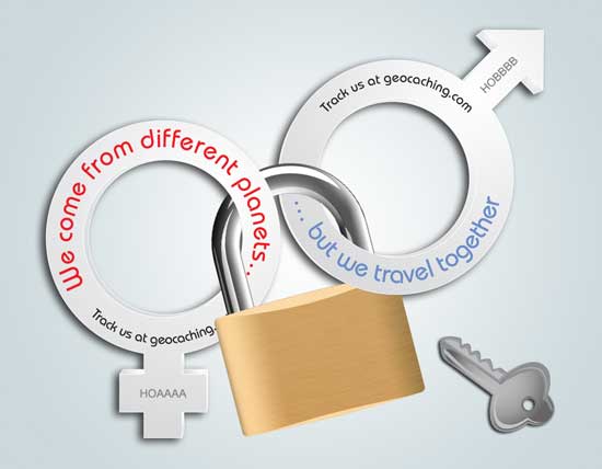
You would get two separate coin, small padlock, and keys. You lock the coins together, throw away the key and let the coins travel together... for ever.
What do you think?
To be honest... eh... I can't see myself rushing out to get it. Maybe the idea will grow on me, but right now, not so much. Doesn't mean others won't like it though.
-
Thanks again, everyone. I'll take a look into making one for the forming of the Bay. Right now I'm focusing on the CITO, so the EarthCache will come soon enough.
-
That's what I was afraid of. I'm doing a CITO near this island, and wanted to place a few different type of caches near by as well. (Plus I've been wanting to place an EarthCache for a while). http://cblights.com/lights/fortcarroll.html
I'm having a hard time finding anything geologically significant (either near the CITO or in general). I'll have to keep on looking.
-
Before I delve too far into my research and planning, I wanted to see if an artificial/man-made island would qualify as something geologically significant for an EarthCache. I would imagine that the construction would need to take the existing and new geology into account.
Thanks.
-
I'm very satisfied with the App Locus. You can load everything offline: Geocaches, maps, spoiler pictures and you have a lot of maps, you can overlay. Of course you can navigate and you have some geocaching-tools like 161m-distance circles and lots more. There are so many features, I still don't know. There is a free version Locus Free and a version you have to pay a little money. You may try the free the free version and then you might buy LOCUS PRO. It is really great! Locus a Geocaching-Live certified App, so I have chosen this. C:GEO it is told to be illegal.
LeoLox, I'd like to play around some with Locus. I did play with it a bit a while ago, but couldn't figure out all the features, it might be that I just need more playing time with it. What do you get in the paid version that you don't get in the free? And how do you download the maps so you can use them off line? What types of maps are available? (e.g. Google Maps? Satellite Maps? OpenStreetMaps?) Thanks for any further info!
-
Someone mentioned it earlier in the project and my concern is still that for some words there are no direct translations

Like "memoires"? (I did appreciate your explanation of the word, and had looked it up on line as well.)
-
Refresh
Nothing new yet.
Refresh
Nothing new yet.
Repeat.

-
One big one: the player could walk into the zone, notice the ammo can, and close the cartridge because the player accomplished his/her objective. This doesn't give the cartridge any time to register that the player left the zone. Still, arguendo, the player is outside the zone when s/he resumes the cartridge, but I don't believe the Wherigo Players store whether or not a player was inside a zone upon save and, thus, the exit event will probably not fire.So I have it when you walk into the zone, it'll pop up the end of the story and the final clues, then when you walk out of the zone it completes the cartridge. Does that sound reasonable? Any "gotcha's" I should be aware of?The ammo can is about 0.1 miles away. There is no zone around it at all, it's separate from the Cartridge (other than the cartridge dropping pieces of the coordinates as you go along). When the player gets into the final zone, it gives the last of the coordinates to the ammo can. I tried running my cartridge on my WhereYouGo (android) today after adding in the closing. I got to the final zone, it gave the final piece of coordinates to the ammo box, then kept pointing to the final zone (which I was already in. I walked away for a while, and still nothing but pointing to the end, so I just closed it down myself then.
-
I'm kind of shoehorning on to this topic a bit. I realized that I didn't complete my cartridge, so I wrote that in at the last minute. I'm going for what I hope will be a final beta test/walk-through this afternoon (plus drop off the ammo box). I don't have a zone for the final location. During the walk around the park, I give various hints (based on numbers on a sign) with the last two (the .xxY for lat and long) being given at the last zone. Then they'll have to put those coordinates into their GPS to find the actual ammo box. No armchair way to do it without walking the route. So I have it when you walk into the zone, it'll pop up the end of the story and the final clues, then when you walk out of the zone it completes the cartridge. Does that sound reasonable? Any "gotcha's" I should be aware of?
Thanks.
-
At work (during lunch break) I created a new cartridge, and added a bunch of zones, dialogs, and events. And I saved, several times) When I got home I was eager to continue. However, while the dialogs and events for the zones are still there, but when I went to ZonePoints, there was no data there, not the actual point or the zone around it.
Both times I was using a Firefox Browser. (Slightly different versions, but I'm not sure why that would have any affect). Any suggestions for what I might have botched up? Looks like I'll have to start almost back from square one again, which is pretty frustrating.
Thanks.
-
Saw the other threads after this one. Okay, I'll be patient longer. (not like I have a lot of choice in the matter).
 Thanks for the info.
 -
Has anyone else noticed this?
Most definitely have noticed this, and it's very annoying, especially as I have to relogin often on several computers plus my phone. Hope this can be fixed quickly!

 Thanks for the info.
Line Breaks
in Wherigo
Posted
Here's what I see on my WhereYouGo:
Line return:
Space character:
Line break:
Lowercase line break:<br>end