


Frodo_Underhill
-
Posts
140 -
Joined
-
Last visited
Posts posted by Frodo_Underhill
-
-
Only a statewide boycott works. By doing so puts greater pressure on the park service to correct the actions done by the one park. It also puts them on notice to not try it elsewhere.No NJ boycott, please. The Parks & Forestry folks down in South Jersey are not involved in this bullying. If you want to boycott the specific locations that are involved, I won't argue, but please don't put the burden on our half of the state.Leave South Jersey out of this boycott nonsense. Bayberry said it well. We have good relations with the Parks and State Forest and want to keep it that way.
-
Got hit with the same log by the same guy on one of mine.
I am finding these logs on the older travel bugs whose tracking numbers consisted only of the digits 0 - 9
I have "grabbed" the bug so that it now appears in "the hands of the owner".
I also posted the following log when I grabbed it.
This travel bug is not in Germany or any other part of Europe. It is lost. Any further falsified logs from those areas will be deleted.Diese "travel bug" nicht in Deutschland oder einem anderen Teil von Europa. Es geht verloren. Alle weiteren gefälschten Protokolle aus jenen Bereichen, werden gelöscht.
Perhaps this will slow down bogus logs.
It would be nice to be able to lock and unlock travel bugs when this problem arises
-
"Then he created a difficult puzzle that he figured nobody could solve, so he didn't hide a cache, which upset the cacher who had spent lots of time solving and looking for it. "
That might have been me - so I can't resist commenting! (But it was over 7 years ago - I think I'm over it by now)
Posting puzzle solutions on line - petty and lame.
Passing puzzle solutions in the background - common, almost expected.
Naming names - I would love to - and it should be done - as we all should know, the truth will set us free. But I would like to do a little research before I make that commitment.
But the same two letters keep coming to mind. Perhaps its in some obscure code known to geocachers.
Time fot this issue to be put to rest. Let's all go out and find some geocaches!
Well Dennis, that incident that happened to you could be the same one I was referring to, or it could be another one with a different cacher.

Either way I still don't enjoy someone asking for help and lying about the reason. I actually really don't mind the puzzle being posted there, but receiving an absurd reason for an answer from a previously banned member takes the cake.
Mark,
Or there could have been multiple incidents - would not surprise me at all knowing the Usual Suspect.
And there may be multiple posters on that facebook page - judging by the number of puzzles that are continuing to be posted.
As for being lied to - that sucks. That kind behavior will ruin a person's reputation. At this point the Usual Suspect has none left in the SNJ caching community. Thankfully he is long gone from our neighborhood. Now if we could package up all the chiggers and forward them to our "friend" for his enjoyment!
Dennis
-
"Then he created a difficult puzzle that he figured nobody could solve, so he didn't hide a cache, which upset the cacher who had spent lots of time solving and looking for it. "
That might have been me - so I can't resist commenting! (But it was over 7 years ago - I think I'm over it by now)
Posting puzzle solutions on line - petty and lame.
Passing puzzle solutions in the background - common, almost expected.
Naming names - I would love to - and it should be done - as we all should know, the truth will set us free. But I would like to do a little research before I make that commitment.
But the same two letters keep coming to mind. Perhaps its in some obscure code known to geocachers.
Time fot this issue to be put to rest. Let's all go out and find some geocaches!
-
Testing 1..42...3
-
That's exactly what I've found. Wasn't sure what it was. As the link is no longer active what would I do with it now? Keep it and just trade it with other items at caches? Or keep it? Still a bit lost. What did they use to be before you changed isp's?
The link was for some tracking I tried to run on my old ISP. I was trying to create a poor man's travel bug system. It was very tedious, required manual intervention and did not work well so I abandoned trying to track them. Much easier to use Geocaching's travel bug system.
It is now a collectable signature item. You can keep it if you like or you can put it in another cache as a trade item.
-
While geocaching I found a cache with a 500 Dollar Geo Dollar I'm assuming would be the name of it. It contained a link on it but did not want to take it as I was unsure if I had to leave a certain item in return.
If someone could explain exactly what this is that would be most helpful.
( I'm relatively new to geocaching )
I noticed you found some caches in my neck of the woods in NJ., so you may have see one of these:

If so, that is one of my signature items - GeoCash. There is no monetary value. Grab it and keep it if you like. The link on the back is no longer active as I changed internet providers a while back. If you want further info on GeoCash, check them out at this LINK.
-
Avatarus testum
-
Puzzle looks fine. Had some fun working on it from the other coast. Managed to get a proper solution with the geochecker. I wouldn't change a thing. Just takes a little deductive reasoning to get the answer. Cache on!
-
sorry about the duplicate posting.
-
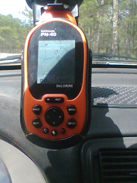
Here is a cell phone shot of my PN-40 with no backlight and the sun hitting it at the right angle. A shadow has been positioned across the screen so that you can see the effect of the sunlight on the screen. Its very dark in the shade but the screen is lit up well for the portion in the sun. No need for a backlight on a bright sunny day provided you have the sun at the right angle.
-
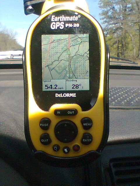
Here is a cell phone photo of a PN-20 taken about mid-day today in the car mount with the sun at a fairly high angle. The power cable was unplugged before taking this picture so the backlight should be off but to be honest with the sun at this angle it is hard to tell as the backlight does not make much difference under these conditions.
-
Yesterday, Firefox started reporting the site with the script to allow for uploading a GPX file with Send to GPS as a "Reported Attack Site". Been afraid to use the script because of that. Does anyone know what is up with that??
-
-
Would be nice to know where this photo was taken in case anyone would like to do their own comparisons.
-
I use dem2topo which also requires ID4 virtual machine. Both are freeware. When I use it, I create a mp file but it also has an option to create a shape file.
One thing to bear in mind is you need different contour intervals for different zoom levels. If your map had a 10 ft contour interval at a .5 mile zoom, your screen would show nothing but contour lines. The way Garmin maps handle this is they have four vector layers that show at different zoom levels. So when you are using the garmin techiniques, you are creating 4 maps. I think I created a shapefile in dem2topo once and it created a shapfile that had the contours for the highest zoom (i.e., all the contour lines). However, if you zoom out and display the map all the contour line would show. But then again I am not sure how Delorme would handle the shapefile at various zooms-maybe since (I have been told) it converts the vectors to raster, zooming out may not be a problem. But perhaps understanding the Garmin maps have four different layers that display at various zoom levels might help you figure out a way to get it into the Delorome.
The water data that is used in the garmin maps is free on USGS servers and it is shapfile. But it is much harder to downlaod than the DEM data.
One thing I am curious about is if someone can figure out how to get the data to work on the Delorome, could a user created map like that be shared?
I have been able to get the elevation data into DeLorme Topo by first using DEM2TOPO to create a shape file and then using SHP2DRW to convert the shape file to a text file for import to DeLorme Topo. I tried a 1 arc second data set and it lined up with the DeLorme base map well. Will need to experiment with the other data sets some more. The 1/3 arc second data was displaced to the SSE about 1000 ft.
What I have found is all the contours come in as the same line. No distinction between major and minor contours. This would be a disadvantage for a map. Some more exploring and stratagizing would be needed before this would be practical.
Your tip on creating different contour levels for different zoom levels would be good. As I have currently imported the data, with all lines shown at all zooms, the screen is a blur of contour lines when zoomed out. Would have to be corrected but this is just an experiment right now.
Regarding your question on sharing the map. It might be possible. The maps that I had made from draw layers in DeLorme Topo were not updated when I upgraded from PN20 to PN40 while all the raster maps were. It looks like the draw layer maps are not keyed to GPS serial numbers while the raster maps are. This would make sense in that DeLorme is marketing the downloads and keying them to a GPS would discourage bootlegging.
For my use, the base map data provided with the DeLorme is more than adequate. If you want more contour detail, there is an option for showing it on the DeLorme maps and you could recut your maps with this detail if need be. Where the technique of brewing your own map may be very useful is in areas not covered by DeLorme's US maps and the data to make the maps is readily available.
All very interesting. Best of luck with your mapping efforts and thanks for sharing the info.
-
...it seems that there exists in the Pine Barrens a rather dangerous hybrid mutant part-human female which appears to be part-Piney monster, part-carnivorous plant and part-human, and it is known that it sometimes lurks near geocaches in order to attack and eat geocachers and their dogs (and even their GPS receivers.)
What is even weirder is that this mutant part-human hybrid appears to maintain a Premium geocaching membership (its account name is "gipsie") with which to better track the movements of prospective victims. Apparently authorities cannot apprehend the monster, and most park rangers are too scared of it to even try to track it or confront it. Due to this constant danger of predation, some of the parks in and near the Pine Barrens, particularly Wharton State Forest, have apparently considered banning geocaching so as to drastically restrict and reduce the food supply for this dangerous part-human mutant hybrid monster.
That's cold.
 She is known around these parts as the Madame of Wharton and her peeps are not amused.
-
1:24000 and 1:100000 are simply scales of the printed source map. 1:63360 is the same as 1 inch on a paper map being 1 mile over the ground....This term 24K maps has been thrown around quite a bit. What exactly is meant by that? Are they a best approximation of the USGS 7.5 minute topographical quads? Or are there specific standards of accuracy for the elevation and topographical feature data?USGS 7.5 minute quads were printed at 1:24000 scale. An older series of maps, the 15-minute series, was once used to map the contiguous 48 states at a scale of 1:62,500.
Lee,
Thanks for the info on the map scales, it is helpful. What I was curious about was what standards of accuracy were being used in compiling the free Garmin 24K maps. They seem to excel in their contour lines which leads to the question of what data source they are using. On the National Map Seamless server, there are three sets of elevation data which are designated as 1 arc second, 1/3 arc second and 1/9 arc second. I am presuming the designation is for the spacing of the data points with closer spacing implying greater precision. I tried bringing the 1 arc second data into XMap using some of the techniques described for the Garmin free maps. Actually got the data in and it produced some very interesting contours. However they were displaced from the actual locations by 500 to 1000 ft so there is some problem in how I converted the data. However viewing these contours on a DeLorme map lead me to the conclusion the free maps render the contours with greater fidelity - if only i could figure out how to get them properly located. However the DeLorme maps are more than adequate for my purposes and much easier to load onto the GPS than brewing your own maps. Interesting to know it can be done.
(By the way the DeLorme maps are correct as I have been to the locations that I was examining and the DeLorme maps match what you see in the field)
But the point of all this is to get to the factual heart of the matter of how good are the 24k Garmin maps. Which I believe for most purposes are adequate but I would like to see more data to support the assumption.
Frodo
-
There have been a lot of claims and counter claims that Brand X maps are better than Brand Y maps but not a lot of comparisons. (The one posted overnight for Mt Tabor in Oregon was an exception) So I took a look at the free 24K free maps for Garmin next to DeLorme's Topo's for the area I live, southern New Jersey. Here are some impressions of the free maps.
+ For a free map project the quality of the maps was impressive.
+ Free maps appear to render the contour lines with higher fidelity than the DeLorme maps.
- The lakes and ponds were less faithful to actual shapes and shorelines on the free maps than the DeLorme map.
- The lakes and ponds were not always identified on the free maps.
- Identification of main roads and secondary roads on the free maps was inconsistent. A series of ditches for firebreaks in the Wharton State Forest were incorrectly identified as roads on the free maps. Let me assure you these are not roads and are barely passable on foot.
- Ground features such as forest, swamp, open fields, developed areas, etc. were not identified on the free maps while they were identified on the DeLorme topos.
- Other than contour lines, roads, streams and ponds and a few points of interest the free maps were deficient in detail vs. the DeLorme Topos
So IMO the free maps are a useful rendering of the free topographic information sources on the web. If you had a Garmin and there was a budget constraint these would be a viable option. However unless these maps have been field verified, caution should be exercised. They are not an end all map - just another resource for your bag of tricks. You alone can determine what map is best for you based on your needs and equipment.
And one final question. This term 24K maps has been thrown around quite a bit. What exactly is meant by that? Are they a best approximation of the USGS 7.5 minute topographical quads? Or are there specific standards of accuracy for the elevation and topographical feature data?
-
Brian,
Try these key GSAK export to GPX settings
* Version - 1.0
* Cache Description - %code
Tried that. Didn't work. The cache info goes away when I try that.
That is weird. Works fine on this end with the Send to GPS program at http://www.findcache.info/pn40/
Try out the GSAK macro referenced in post #89. It works really well.
-
comment withdrawn - sorry for the bother
-
The fact that I don't understand any of what you just said has me enraged too!
But seriously - aren't some of these ALR caches getting a little bit out of hand? Attend so many events, find so many puzzles, do so much of something. A few of the challenges have been fun but I suppose there can be too much of a good think. Thank TPTB for the ignore function. Up to you to ignore what you choose to. As it should be.
-
I'm still looking for a way to have the GC# as the waypoint name, but NOT lose the cache info. Now, when I try any of the suggested methods (e.g. GPX 1.1, GSAK macro) the cache info no longer appears in the comments field.
Brian,
Try these key GSAK export to GPX settings
- Version - 1.0
- Cache Description - %code

To have the names show up, change the Cache Description to %name
Here is a comparison of PN-40 screenshots for using cache codes vs. using cache names:

Good luck with the PN-40. Once you get it set the way you like it, I believe you will swear by this GPS rather than swear at it.
Best of luck,
Frodo
- Version - 1.0
-
One more thing. I decided I can't stand that darn Topo 7.
When I try to load the precut maps directly to the SD card, it freezes more often than not halfway before completing. It just sits there and won't cancel and won't load. I can't even get the CD to eject and I need to re-boot my PC. It took me all night to load the pre-cut maps last week.
And I just received my replacement unit and thought I could just pop in the SD card with all the maps on it. Nooooo, the maps aren't registered with that unit. I have to delete them and go through all this again.
It's been 2 hours and I've had to reboot my machine twice and I'm still not halfway through my loading of eastern maps.
That is not normal behavior for the program. The precuts should load right in w/o and trouble.
Now if you cut maps they will be registered to your GPS. However if you have a new GPS and call up Topo 7, it should recognize the new GPS and then register any maps you have already cut w/o having to cut them again.
Check over on the DeLorme boards - you'll get good support and answers over there. Over here - you get what you get - its potluck.
Moratorium on placing new caches in NJ state parks?
in Northeast
Posted
BUMP
This topic looks like it has scrolled off the page. Has anyone heard anything new lately? Last I have seen on this topic was a posting earlier this month by nickap on the CJG board to the effect that the policy is still pending and that parks management is watching and evaluating the impact of key caches.
The crickets are quite noticeable due to the lack of information on this topic.