


cx1
-
Posts
434 -
Joined
-
Last visited
Posts posted by cx1
-
-
A couple more questions (I seem to have an endless supply...thanks for everyone's patience!)
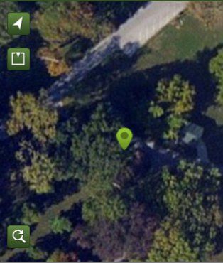
The iPhone lets you switch between a street map and a satellite image (very handy for identifying trees, buildings, etc in relation to the cache site). Is this a common feature on most GPSrs? How is this feature described in a unit's specs so you know if it has this ability or not?
Many GPS units will allow for satellite imagery. On a Garmin you would look to see if it is compatible with Birdseye I believe. On other brands you would look for terms such as 'color aerial imagery'.
However compared to the satellite imagery you get on an iPhone it is very disappointing.
Satellite imagery takes a vast amount of data. You phone can mostly avoid this issue because it can download the data as it needs it(if you have signal). On a typical handheld GPS unit you would need to preload all that data from home. This is a tedious process because you have to select which tiles of a given area you want, what zoom levels you want and there is sometimes a limit on how much data you can request at one time. So it may take several different data requests to get the area you want covered. Often the servers that offer the data for handheld GPS units are also very slow. So even with a fast home internet connection it can seem like you are trying to download data on an old phone modem. Your handheld device can only store and sort so much. So each time you want to go caching to a new area it means repeating the lengthy process of downloading new aerial imagery to the device before you set out.
The detail level or zoom level for the satellite imagery you can get for a handheld GPS is often very poor compared to the details you can see on the maps on your phone.
iPhone map of a nearby cache
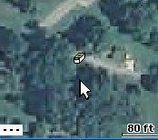
GPS map of same cache from a PN-40
Now image quality is is going to vary by location and provider. But generally the better aerial imagery is going to be on the phone.
Also the imagery is going to cost you. Some companies Garmin and Delorme I know and maybe others offer a yearly subscription to satellite maps for around $30. But like on the Lowrance GPS I have it was a fee per tile when I looked into getting the aerial imagery for it(it may be different at this time).
I am just providing this information so you won't be disappointed like I was when I decided to go to a GPS unit that supported satellite imagery.
-
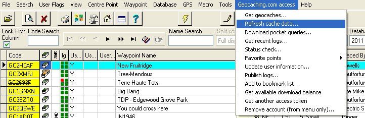
Can you explain what the GSAK geocaching.com tool is? One of the macros? Sounds like a good tool to use.
Thanks.
It is a tool built into the GSAK program
-
And at the same time, I'll hide one across the street from the Police station and require all finders to be totally naked. Which one do think will get published first?
Hmm, lets see.
First there is a large difference between the words require and request. They are closer to antonyms then synonyms in this context.
Secondly my cache idea does not suggest or demand that the finder perform an illegal act whereas yours does.
I'd say mine would be accepted and published quite easily by a local reviewer. Your idea, not so much.
-
I find it interesting that you feel the need to distinguish this type of telepresence "find" from an armchair "find."
If someone armchair "finds" a cache and courteously predates their log to a time before the last find log, then their action also doesn't effect your found count. Yet you, like many other geocachers (including me) and Groundspeak, seem to frown upon this type of behavior. Why? Why do you think Groundspeak has archived some caches whose owners regularly fail to delete such bogus finds? Why do you think Groundspeak bans geocachers who use bots to log bogus finds?
Actually I have no issue with the bit in bold at all.
It would not cause me to frown in the slightest. I normally use the last two logs to decide if I want to attempt a cache. If someone sneaks in a predated log four or five logs back I will probably never see it.
I do feel that there is a vast difference between someone who sees a cache (either at the site or via a live video feed) and can accurately convey the cache condition versus a typical armchair logger who has no idea if the cache is there or not. I do not feel they can be considered close to the same thing. Some people in this thread are tying to portray them as being the same and I don't see how they are. One is an informed assessment and the other is a blind guess.
As far as what Groundspeak does or does not do is not for me to speculate upon. They are far from consistent enough for me to be able to judge their motivations.
-
I'm going to place a cache in my front yard, I will then invite cachers from all over the word to contact me via some kind of video feed or anther when they are at a cache location near their home. I will then show them my cache, they will show me theirs. I will log them in on my cache, they will log me in where they are. I will have countless caches, states, countries logged, I will be the world greatest cacher.
And that will not effect how I feel about my own personal accomplishments in geocaching at all.
All my finds will mean exactly the same to me after you do that then they did before.
You found a 5/5 in Tibet,a 4.5/3.5 in Wales and grabbed a virtual in Maui all on the same day? Whoopie doo. I'm not looking at your stats anyway so how would I know and why should I care? They are your numbers not mine.
I could be called the worlds worst cacher, but if I'm having fun it's all good.
I don't see how worrying about how other people log is fun.
-
Now let me also ask you, would you be OK if geocaching got to the point where more than half of all logs were via some proxy method by a person miles or even thousands of miles from GZ? I wouldn't, I'd think it turned into a joke.
Why let what other do effect the way you feel about your own personal accomplishments?
Other then potential maintenance issues going unreported(which with an actual team member at the cache site this is really no issue) what really do fake or bogus logs from virtual team mates do to damage your experience of finding a cache. Team A logs a 'fake' find and 3 real finds because of their one virtual member who was there via Skype, Teams b-y all log fake finds and real finds consisting of the team members who were on site and those who were at home. Here you come as person Z, enjoying being outside and find the cache without problems and the cache is in good shape. How are you harmed by those fake logs? Did you burn less calories doing the hike? Did the sun suddenly not shine as bright?
Or say all those logs were real and genuine. Every single team member caressed the log with their own little hands. And you don't find the cache. Is the overall experience specifically for you better because the previous logs were real?
If a person wants to claim a find from 1000 miles away and they got their name on the log sheet via a team member who was actually at the cache then what difference should it make to you or me or anyone really? It doesn't effect my found count. It doesn't effect your found count. You don't win anything if your find count is higher then mine or theirs do you?
So what if one member of a caching team is there virtually instead of physically? At least someone was there. The person with the camera was at the cache. This is nothing like armchair logging where a person claims a find with absolutely no idea if the cache is there or not.
-
Anyways, read the post above mine, seems the official answer is that this type of logging is not acceptable.
Read my sig line, her boss may not agree.
-
Personally if I had to choose just between those two I would go with the Dakota.
I don't like touchscreens but I like having lots of different maps more. So I would suffer with the touchscreen to get the maps.
A Garmin is going to give you the widest selection of available maps many at little or no cost.
I cache with a person with a Magellan (not the 310 though but the model below it the GC) and while I am impressed with the battery life and form factor of the device I was not impressed with the maps. Maybe the 310 has a better map. I looked on the website for them(GC vs 310) and they are described almost identical as far as maps but I am not certain.
What made you decide just between those two? They are not very similar really.
Dakota PROs (IMO)
Many map choices
Turn by turn navigation (admittedly I would never use that feature probably if I had a Nuvi)
Electronic compass (admittedly I have poor luck with these as well)
User storage is expandable with SD cards(only seeing 500MB internal on the 310 and no card slots)
Established firmware so fewer bugs
Larger support base of forums and user groups with Garmin
310 PROs
Can hold more geocaches 10000 vs 2000 (I think)
Not a touchscreen (and that is not a pro to many people)
Reference the OS Grid for use in Great Britain (not sure if the Dakota can do that but imagine it probably can but since I'm not sure I'll give it as a slight plus)
Personally not seeing a whole lot going for the 310 /shrug
-
Glad to see some people agree, the idea of this thread really irks me because if this was allowed the abuse that followed would turn Geocaching into a joke.
Because finding boxes in the woods that might have some toys in them is some serious business.

I always wonder about those who leap up and shout "I'll delete your log" if it is just that little scrap of imagined power that prompts one to even put out a cache. As if by golly if you couldn't delete logs well then you would just not play at all.
Anyway I think I am going to put out a cache that specifically requests that people actually find it via a video link of some sort. Something along the lines of once within 25 feet of the coordinates then all movement must be guided directly by the remote viewer. The video operator could even wear a blindfold. The viewer could be in the car, or at the trail head or even at home. Just as long as they specifically did not have a direct line of sight to the cache area other then the video link.
Of course I would not delete their log if they found it in a more traditional fashion. That would be an ALR.

Some people just don't have access to the needed video technology. And some people just always cache alone. And some people will only do what they want anyway so why should I get all upset about it

I think it would be quite difficult to find a cache by this method for several reasons.
You would have a very limited field of view. Instructing the video operator for each little pan left or right and up and down could take a very long time to get even a sense of the area.
You depth of field would be compromised. Is that a small rock far away or is it a large one that is quite close.
Each potential item of camouflage would need to be examined at the specific request of the remote viewer.
Not only would the remote viewer need to guide the camera they would also need to guide the movements of the operator(don't forget the operator can't see).
It really could be a fun cache.
Just try doing a few simple tasks around the house while only using the camera of your phone for your vision. It is really not as easy as it may first appear.
The way the OP describes it I would say it is a far cry from an armchair log. It could possibly be more difficult and more fun to find a cache that way then to actually be on site. So who is missing out on what exactly?
Very interesting idea.
-
Don't know about logs on the Dakota, on the Etrex 20 you get the last 5.
I am curious as to this last five log issue.
How do you get the data on to your unit?
If you are simply downloading GPX files from PQs then yes you would only have the last 5 logs(if 5 logs have been made) because that is all the Groundspeak server will send in the PQ.
I tested this by downloading a small PQ (29 caches)to a new database in GSAK. All the caches only had 5 logs (except one odd one had six /shrug and one only had four since it is new). I then used the GSAK geocaching.com tool to refresh cache data which will allow you to pull up to 30 logs for each cache. After that refresh most of the caches had 30 logs and only four caches had less then 10 logs.
GSAK will allow me to decide how many logs I wish to send in my generated GPX files. I normally opt for 10-20 logs per cache.
So what I am getting at is the 5 log limit a result of the unit only being able to display 5 logs even if say 20 logs are in the GPX file or is the 5 log limit because that is all a PQ direct from GC.com will have?
-
Wow, those screenshots look amazing. They are the best I've seen for geocaching specific images of the maps on an etrex. Thank you. These put me much closer to purchasing the etrex.
As to this statement
In the field the Etrex lists the caches from nearest to farthest so there's no need to wade through hundreds simply to find the one you want.I would have to disagree. We are planning a trip to Ohio for example. We are going to grab a cache on the west side of Indianapolis right before we get on I-465. Then once off I-465 we will stop for another. The caches are only 12.5 miles apart. Sorting by distance there are 901 caches to sort though between them and that is just in that county. If I include the area of the county to the west and just use a 12.48 miles radius which is what a sort by distance filter will do there would be 1179 caches in the list between the cache I am at and the one I want to go to. This is an extreme example certainly but less extreme examples did happen (100-200 caches and even scrolling through 50 caches is tedious if you need to do it for every cache)when I used the Endura which handled gpx files just like the etrex. It was one of the main reasons I went to the pn-40 because with it I could have all the data available for those 1179 caches in the unit but in my current list the cache I want would probably be the next one or at the most maybe 4th in the list. Yes I don't 'need' all that data. But I've gotten used to having it. The etrex would force a much more selective planing of the data I want to keep with the 5000 cache limit considering right now my pn40 probably has 3x that in it (admittedly in many gpx files of 500 caches or less the county Indianapolis is in takes 4 gpx files for example).
But enough on that I will have to live with the limitations in that regard. I suppose I could simply carry two SD cards where one has the planned caches and one has all the caches in the area and swap them if need be.
Back to geocaching specific features. Notice on the image I posted in the first post the mystery icon and the little flag to the northwest of it. The flag is the child waypoint of the solution of the mystery.
How does the etrex handle child waypoints for caches?
On my pn40 I have to switch from geocaches to waypoints(they are kept in separate lists which are resorted each time you access them), navigate to the waypoint and then switch back to the geocaches list to make my field notes and have access to the description and logs etc. For single stage mysteries it is not bad. But on a multi-stage mystery where you need to figure new waypoints at each stage and have need of access to the cache description to compute the next stage the constant switching between waypoints and geocaches gets old. I don't like to change the given coordinates for the cache itself in case I get to a point where I need to start over. And I like to keep the locations of the stages in my database.
The project new waypoints feature on the etrex is not clearly explained (at least what I've found so far) as to if it still stays within the geocache information while navigating to the new waypoint or like on the pn40 the waypoints and geocaches are kept separate.
Field notes. Do you have to enter any information or can you simply mark 'found' or 'not found' and move on? On my pn40 I can simply mark them but on my phone I have to enter 'something' even if it is just a space before it will allow me to submit the field note. Of course I am posting real logs to the cache page when I get home this is just for the temporary field notes.
Working in the cold. How does the etrex fare? My pn40 is awful in the cold and I'm not sure if it is battery related or the units fault. I have eneloops ordered to test this but I doubt it is just the batteries. I've been doing more cold weather (cold to me anyway 12-15 degree F) caching and the pn40 is acting up more and more. My buddy's older style etrex(monochrome and no maps) has been doing fine in the same conditions and with the same type/brand batteries.
Holding signals. If I don't set the pn40 on the dash while in the car it will loose its location. Sometimes I forget and when arriving at the next cache parking spot I get out of the car take the pn40 out of my coat pocket and it has no idea where it is. Currently it will only rediscover its location if I cycle it off and back on (last firmware update gave me that little jewel of a feature). How does the etrex fare under those conditions?
Thanks for all the information so far. It has been very helpful.
-
Well it sounds like with some tweaking I will be happy with the maps(I love OSM) and unhappy with the gpx management. Not sure if that is a deal breaker or not.
I suppose many people are satisfied with the single list arrangement. Is the sorting quick once the gpx is loaded?
My endura used a single list and large gpx files would take forever to sort.
I would think with Garmin being one of the early supporters of caching that their units would have the most beneficial features. But for data management they seem a bit behind the curve. The whole remove the gpx, reboot the device, load new gpx and reboot again before using that I've read about seem a bit much to jump through every time I want to update my data. Maybe that has improved from the last reports I read. I'd love to see a filter for user flag in the unit along the lines of the size/difficulty filters built in if they won't do individual gpx files. Seriously, how hard could that be?
For the longest time I've been trying to get my caching buddy to move beyond his paper lists of caches we want to do and if I 'upgrade' to the etrex I'm going to need his lists to keep track of the next caches lol.
I've not had a Garmin since my original old yellow etrex. I really want to give them another shot and the new etrex ticks the right boxes except this gpx business. I've been waiting for a no touch screen Garmin and the 62's just don't reach that price point/features balance I want to be at. The etrex 20/30 is so close to being the one.
As far as my data being stale. Not saying it hasn't happened. But it is rare. Weekly PQs cover my 100 mile radius, notifications provide a redundant daily backup of 49.8 or whatever (it won't do 50 miles) and GSAK allows me to refresh 6000 caches a day beyond the PQs. I've skipped refreshing a county a time or two and gone after some archived ones but I've helped save some 'lost' travelers that way so it balances out.
So the adventure thing on the Garmin will not do what I want? Or has no one tried it in that fashion?
Thanks for all the replies so far. A screen shot of the Garmin running the OSM would be nice to see. I'm going to see if Google will help but feel free to post one just in case

-
Ok,
So I am having a great deal of frustration with my PN-40. Plus I have had it awhile now and sometimes it is nice to have something 'new'.
The etrex 20 or 30 have caught my eye as a possible upgrade. Can't yet decide if chirp ability and compass (the only two features I might use) are worth the upgraded price between the two. But that is not what I am asking about.
Right now I really like and am somewhat spoiled possibly by the basemaps on the PN-40 and I am trying to see how the maps for that etrex compare. I will post a screenshot to explain...
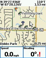
Notice the icons first of all. Can I get the actual cache icons like this or would I be stuck with treasure chests?
Also notice that the display shows the distance and bearing of where the pointer is relative to where I am. Will the etrex show that?
Also notice that the display shows what is directly under the pointer. In this case it is Dobbs Park. Had the pointer been above a street it would show the street name. And even the little tiny streets are named and will display. Or if it was above a creek/river it will show that name as well. Will the etrex maps do that?
My second major concern is the gpx file management. For example I am planning a trip through 3 counties where I will be seeking 37 caches. On my pn40 I would create and load 4 gpx files for this trip. One with just the 37 caches I plan to get and then one for each of the counties I will be passing through. I set it up this way so I don't have to page through all 700 or so caches that would be in the gpx if I combined them all. I find it very convenient just to look though the list of 37 (and they are removed as I find them so the list shrinks) rather then looking at all the 700 caches. Plus 9 times out of 10 if I click go to next closest it will be the next one on our plan since we plan our trips mostly in loops.
But I like having the other cache information at hand in case something would come up and we decided to get a cache or two that was not part of our original plan. With the county gpx I have that info available. For example we put all the caches in my database 16,000 or so into the TomTom for cache to cache routing. The caches are set to display on the map so we can see if we might be about to drive past one we hadn't planned on. I can open the county gpx on the pn40 and have all my cache info. Then when done I can go back to the gpx of just the ones planned.
From the way it sounds the etrex will just lump all my carefully sorted gpx files into one big list. Is that true?
If so could the adventure function of the basecamp software be used to somehow just have the planned caches? Maybe drop a gpx of the caches I want into the adventure generator software thingy and then slide that onto the etrex and cache directly from that(with hints,logs, field notes etc)?
If I can at least sort between planned for caches and one big list of all the rest I might be able to settle for that.
Thanks for any and all assistance.
-
My pn-40 suffered a similar problem when I updated firmware. On the pn-40 I had to go to device setup - connect to computer and select transfer to SD card and then GSAK would send my caches over without issue. After doing that once it now seems to work each time I simply plug the pn-40 to the computer even if the pn-40 is set to the default use gps when connected.
-
They (Goundspeak) need to be consistent on the listing requirements. We have 3 approved locally (so far). Two are listed as a multi-cache and one is a mystery/unknown. Two show the wireless beacon attribute and one does not. One is listed as a 5 difficulty and two are not. Two are listed very clearly that they require a smartphone with NFC capabilities and one does not.
From the way the guidelines and the above linked discussion it would seem to me they should all be listed as...
-Difficulty 5 due to special equipment needed
-Mystery/unknown
-Wireless beacon attribute
Not one of the three locally are listed with all three.
Shouldn't they be all listed the same?
-
Can you do it on an aerial view...no.
Way too much angst over maps.
And on the 13th I could. And there is a way I could use Google Earth to accomplish basically the same thing but for some reason they want to introduce inaccuracy to the cache locations if one wishes to use the Google Earth directly from the webpage. Seems silly and counter-productive.
What there is way too much of is some people wanting to trample on other people for suggesting an enhancement as unnecessary.
If you are happy with the new map system, great for you.
I believe the thread title is not "I love the new maps" though.
You find the feature of viewing multiple caches accurately listed on a good aerial tile as unnecessary. Great, don't use them if they become available again. But adding them will not negatively impact your geocaching so why be so against something that would have a positive impact on other cachers?
-
But you can still do that, just not with every map type your little heart desires.
What does the size of my heart have to do with wanting the caches displayed in Google Earth to be accurate?
On February 13th I could view nice aerial imagery showing the detail I wanted while viewing multiple accurately placed cache icons on a map completely within the geocaching website. I can not still do that today.
Allowing the KML generated for viewing in Google Earth to be accurate would a viable alternative.
It seems counter to the entire concept of mapping to intentionally display locations incorrectly.
-
But why do you need to see all the surrounding caches at the same time that you want to determine the above?
Because if I am already there to get one cache it is nice to see if there is another nearby.
If I am going to a park to get 3 caches it would bother me to overlook the 4th one since I may not make it back to that park.
Switching to another map seems very inefficient just to see additional caches when the technology is there to easily see all the nearby caches on a map style I find the most useful.
From what I understand, using the Google Earth interface hits the database pretty hard. If it used exact locations, people could use it to retrieve bulk cache information rather than by using Pocket Queries. Groundspeak would much rather we use PQs (less hit on the database), so they've introduced the intentional error to dissuade over-use.
Perhaps you could explain this a little better because I do not quite understand. Groundspeak does not host (yet) the map tile images.
On a street map I can view an area with 500 caches.
On a poor aerial map I can view the same 500 caches.
Yet seeing those same 500 caches on Goggle Earth would generate more load on the Groundspeak server so the server takes the additional step of altering the data prior to displaying it?
And couldn't the person retrieving bulk cache information via Google Earth also retrieve this same information off of the regular maps which have the correct coordinates?
I am also not understanding how much more difficult it is for the server to generate a KML file opposed to a GPX. They are both simple text files.
-
Why do you need to see the exact locations in Google Earth?
Hmm, could be I like to know what side of a street a cache is on so I know where to park.
Or maybe I want to know if it is inside out outside an area that is not open at night.
Could be I would like to see if maybe it is a LPC or not.
Might be nice to see what side of a river the cache is really on considering locally the bridges to cross the river are 14 to 20+ miles apart.
All of this is information I should be able to glean from simply viewing an accurate aerial image of the cache location.
Technically we don't need any maps at all. But there is absolutely nothing wrong with asking for them to be as useful and accurate as possible. The current maps while allowing to see caches accurately positioned on a map have terrible aerial tiling support compared to what we had with Google. This whole mapping mess really opened my eyes to how great the Google maps really were. Using Google Earth is a tool that can help bring back decent aerial imagery support.
Why do you need to keep this method of getting aerial imagery from being as accurate as possible?
-
* Replace the +/- zoom control with a slider/picker that allows one to go directly to a zoom level rather than single stepping with each click.
I'd rather have the slider added, not as a replacement. When using a mouse I like a slider but when using a touch pad I end up over-sliding and need the one step per click option.
* Add a "Save as KML" link for easy importing into Google Earth.
Without the 100 meter or whatever it is variance please. Since the aerial view tile supplier for the current maps is not really ready for prime time Google Earth is the only easy option for some folks. Let them have the caches displayed as accurately as possible.
* Show caches which the owner has logged a DNF (and no subsequent Found It) as a blue frown face
First, this information on what caches a person has logged a DNF on should be available as a PQ option as well as on the maps.
Second, why not have found/DNF caches displayed with the original cache type icon with either a check mark or a 'X' in the corner of the icon denoting found/not found like some other applications do?
* Add a "Print Map" button.
* Add number labels to each cache icon that corresponds with the list of cache names (even if only available in the "Print" output)
* Sort the names of the caches from a Pocket Query alphabetically.
A big yes to all three.
-
It's not just the number of caches shown on the map, it's the tiling process for displaying them.
How difficult would it be to add a radius system similar to my earlier example to the system now in place? Even if it was limited to only displaying a maximum of 25 caches in a given radius it could be quite helpful and I would think that 25 caches would not hammer the servers near as hard as the older 500 limit.
-
I have never liked the beta version of the maps. I knew it was just a matter of time before they went from beta to the only option. So I had started looking for useful mapping alternatives that worked in a way that I wanted them to work.
While I do enjoy Google Earth it is a bit clunky on my underpowered little netbook that I often use for planning cache trips while watching television. I also liked having the lists of the caches and the numbered labels for them like on the pre-beta geocaching maps.
It turns out that for those willing to use GSAK there is a very nice little macro that comes very close to replicating the old map experience.
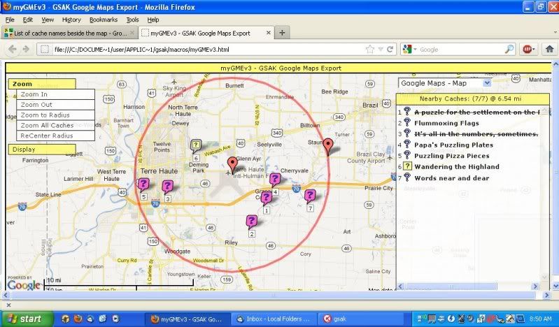
The list and other menus can be hidden with a simple click so you can see more of the map. The labels can be switched on and off. The list is controlled by the red radius circle visible on the map. Make the circle bigger and more caches are in the list, a smaller circle makes the list smaller. This is controlled by use of the two red pins which can be dragged across the map to wherever the user desires.
The details the caches display when clicked can be modified using the GSAK codes. The macro can use any user created filters or display only the currently used filter or just the caches in the current GSAK grid. It will also use clustering (if desired) when viewing a large area of caches.
I have tried it with a filter that ended up with several hundred caches and it worked very well even on my poor little netbook.
And this is all done on a Google map where you have the options of map, satellite or hybrid for the map tiles and can switch back and forth between the map types with a simple pull down menu.
I only used my own caches in my example as to not cause any angst by showing another person's caches on the forum.
-
I'm having trouble finding where the experience level of geocachers is listed.
Well lets see you have an established local cacher with 1k+ finds, several hides actively maintained and has been a member of the site for several years.
On the other hand you have a cacher with 35 finds, zero hides and has been a member for two months.
While it is not 100% proof positive I would be comfortable assigning a higher experience level to the first cacher when judging their DNF logs for consideration of my own attempt at finding the cache.
Sure it is not an absolute perfect system. There are probably some rare folks who might have a great deal of experience that is not reflected in their account statistics. But in general a person with more then a few finds and more then a few months of activity is going to be more experienced then a person whos stats make it appear that they have just started playing the game.
I know personally I became a great deal better at finding caches after I found a few hundred and was exposed to a variety of hiding techniques then I was when trying to find my first 50 caches.
As to the OP...
For local caches I am not generally picky about DNF logs. There are too many factors to list to determine if I will attempt to find it. Currently within 5 miles of my home there are 97 caches available that I have not yet found.
I tend to cache in trip events. That is I will travel to an area specifically to find caches in that area (and maybe try a local place to eat that I have heard good things about). 65% of my finds are greater then 30 miles distant from my home.
When planning these trips I pay close attention to the number of DNF logs. So if a cache has a certain ratio of recent DNFs (this varies with cache density of an area, a cache rich area will allow me to be more picky) then I will not include them in my trip plans. Sure I may miss a good cache here and there, but I always have the option to returning to an area on a future trip and perhaps then the ratio will be different and the cache will then be included in the plans. This is why I wish people would only log a DNF on a cache if they actually attempted to search at the coordinates for the cache. But since I can't influence those who feel a DNF is ok if they only thought about looking for the cache I accept the fact that I may miss a few good caches on my trips. Which in the end is not a huge deal since I'm never going to find all the caches anyway.
-
From the Guidelines:
Geocache placements do not deface or destroy public or private property. Geocaches are placed so that the surrounding environment is safe from both intentional or unintentional harm. Keep both natural and human-made objects safe. No object or property may be altered to provide a hiding place, clue, or means of logging a find.But of course if Groundspeak chooses to ignore their own guidelines in one of their geocaching videos then defacing something like a wooden bridge is ok.


Fraudulent Finds
in General geocaching topics
Posted
Why is this a dilemma?
If you are not the CO or the previous finder then why would this have any effect on you?
Are you in some type of competition with this previous finder?
As others have mentioned there are a multitude of reasons why you might not find a person's signature on the physical log yet they have logged the find on-line. So are you wanting to make it your business to specifically know why it happened in each particular cache you happen to run across?
As a cache owner or as a cache seeker I would think you were being a busybody if you contacted me about it either way.