


ibycus
-
Posts
2073 -
Joined
-
Last visited
Posts posted by ibycus
-
-
Been a while since I released a new version. I'm starting work on version 5.0, and wanted to get some feedback as far as things you might like to see (anything not in 4.0? Any little annoyances? etc). (Updated data is of course a given).
-
I got a problem...the downkload is complete...I got it burnt to a dvd but when I go to install it I get a warning like this...I hope the picture shows up.
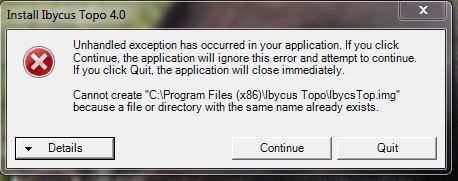
Try installing to a different directory. Looks like it's trying to overwrite an old version and having problems.
Dale
-
I don't understand this.
When I look at the torrent it shows that I have downloaded 2.4 gb.
On my hard drive I have an iso file "ibycus topo40.iso" that shows that it contains 4.06 gb of information.
Also the torrent shows that the total file size is 3.78 gb.
So is the iso file not the complete download and why would it show as being larger than the file that I'm downloading?
A lot of clients pre-allocate the required space. That way you don't run out of hard drive space part way through the download, also it makes it easier for the program to download parts of the file in a non sequential manner and keep them all in the right order. In other words -- you aren't done yet, believe the value in the torrent client.
Oh and the 3.78 vs 4.06 is likely a base 10 gigabyte vs a base 2 gigabyte...
Edit to Add: Just thinking --- I don't know if everyone understands base 2 gigabytes vs. base 10 gigabytes.
As I'm sure most people do know, computers have 'base 2' at their heart (ones and zeros). Consequently a lot of things on the computer come in multiples of 2 (i.e. 2, 4, 8, 16, 32, 64, 128, etc).
Way back when, it used to be pretty standard for people to understand that a 'kilobyte' was actually 1024 bytes, and a megabyte was actually 1024x1024 bytes, etc.
The problem is, in the SI system, kilo, means 1000, not 1024, so some people decided that they could make capacities look 'bigger' by expressing thing as 'base 10', rather than base 2 (and have a good excuse for it in the process). This was typically a ploy of hard drive manufacturers.
If your competition was selling a 540MB hard drive, and you had a 566MB hard drive that you sold for the same price --- guess who sells more? Do the math though, and you'll see that they could technically have the same number of bytes.
So we have a mixed standard. Lots of people still insist on base 2 arithmatic, but others have shifted to base 10. (Personally, I'm more comfortable with base 2).
These days, the difference in sizes can end up being pretty significant. For example, on a "1TB" drive, it coule be either 1099511627776 bytes, or it could be 1000000000000 bytes a difference of 92GB!
-
Going to bed now, and shutting down my computer for the night. Any downloading will stall out when you get to about 800MB. Don't worry though, it will start up again in the morning.
Dale
-
Torrent file is available at
http://www.ibycus.com/ibycustopo/IbycusTopo40.iso.torrent
MD5 Sum (for those who know what this is)
3ddd5edfaf793f9cadc6f449ec6d55e4 *IbycusTopo40.iso
When I click on that link all I see is a very large page of letters numbers and symbols.There must be something I'm doing wrong then eh?
Do you have a bit torrent client installed? If so, try again now...I've made some changes on my end.
-
Torrent file is available at
http://www.ibycus.com/ibycustopo/IbycusTopo40.iso.torrent
MD5 Sum (for those who know what this is)
3ddd5edfaf793f9cadc6f449ec6d55e4 *IbycusTopo40.iso
-
Just a quick note here to say that I've *finally* finished work on version 4.0 of the maps.
This version includes new roads for much of the country (including Quebec, which hadn't been updated since the maps came up), as well as more areas with road names.
Also there is a new version of the underlying dataset for the topo data.
Finally included are what I *hope* are all of the more minor roads that disappeared between version 2.1 and 3.0. These are included as a transparent overlay that can be added to the maps (or any map for that matter).
I hope to get the torrent of the PC version going tonight.
-
Dale, we've discovered another small problem with 3.2. When trying to extract the files with 7-zip it says it can't open the file as an archive. Any thoughts?
so don't extract it with 7zip? it's not a 7zip archive, it's an ISO image.
7-Zip handles ISO images. Just not this particular one. After doing some more testing and poking around on the internet since entering that message, it appears that there are some specific types of ISO image that make 7-Zip gag. The Ibycus 3.2 file is one of them. It handles others fine.
...ken...
Interesting --- I'll have to play around with how I make my ISO (this one was made with Cyberlink "Power2Go"...I think)
Do you have any specific information on which 'kinds' of ISOs make 7-zip choke?
As a 'workaround' you can always mount it with Daemon Tools.
-
Houston I have a little problem.

I downloaded and installed the ibycus 3.2. (dl over torrentlink from this forum)
If I load the maps (for example victoria island) to my garmin, i get an error message:
"File not found looking for image 30920020. "
In my imgs-Folder is no image with this number.
Miss the download some image-files?
Hmmm... This concerns me a little. I've had a number of people comment to me recently that there are some files missing or inaccessible from the ISO download, but I really don't know how this could happen.
(perhaps someone here more familiar with BitTorrent could enlighten me)
I assume the download finished without any errors? What client are you using to download? What are you using to extract/burn the file?
-
oh, oh, I know this one, both the answer and the cacher. but I don't have a followup question so I'll leave it for someone else to have fun with. I hope to one day get as many of his capital caches as is now possible.What Canadian geocacher has placed a geocache in England that currently has 70+ watchers and is closing in on 5,000 Finds?
Me too! But I would also be out hunting for a new question for a while, so I'll leave it.
-
Think I figured out where that data is missing... are there any other areas with things other than forest roads missing?
Some trails, some POIs.
With 3.1 the Skyline Trail near Jasper stops at approximately N52 45.000 W117 46.893, whereas 2.1 shows it completely.
Both mapsets show the trails around Lake O'Hara, but 2.1 has more POIs, eg "Cabin" (a favorite of mine) at N51 21.304 W116 20.608, and assorted lake names in the area.
Hmmmm...POIs might be difficult (I'll have a look though). The problem is avoiding duplication.
I'll check out that trail.
Dale
-
Ibycus, I too would like to thank you for your hard work and time in producing these maps. I have been using V2.1 for the past few years in my 60cx and have found the maps to be very useful
I recently downloaded V3.2 and found the while some roads in developed areas have been added, I was disappointed to find that most logging roads in the areas I frequent are missing.
These screen-shot show the difference between the two versions and are representative of a much larger area of the BC Coast and areas in northern BC that I visit. The center of these maps are approx N49 29.155 W123 37.965
That is quite the difference. I'll have a look in to it, and see if I can figure out where the extra data was coming from...
Dale
Think I figured out where that data is missing... are there any other areas with things other than forest roads missing?
Dale
-
Ibycus, I too would like to thank you for your hard work and time in producing these maps. I have been using V2.1 for the past few years in my 60cx and have found the maps to be very useful
I recently downloaded V3.2 and found the while some roads in developed areas have been added, I was disappointed to find that most logging roads in the areas I frequent are missing.
These screen-shot show the difference between the two versions and are representative of a much larger area of the BC Coast and areas in northern BC that I visit. The center of these maps are approx N49 29.155 W123 37.965
That is quite the difference. I'll have a look in to it, and see if I can figure out where the extra data was coming from...
Dale
-
Firstly, thanks for your work and dedication Ibycus. I have been comparing 2.1 and 3.2, New-Brunswick region and version 2.1 has a more complete backwoods trail data. Since I snowmobile and 4wheel these trails, I will stick with 2.1. I go between Ibycus 2.1 and Garmin topo 4 on my GPSMAP 60Cx and couldn't be happier. It is a shame the garmin topos do not have the colors for wooded and field areas like the Ibycus maps. Keep up the good work Dale. Hope you don't mind me promoting your 2.1 version mapset instead of the 3.2.
Would others care to comment on the trail information? In Alberta, I use Red90's trail maps, which I can't even come close to as far as trail data goes.
I could in theory extract the trail data from the old dataset, and create an overlay, or potentially overlay it directly on to my maps. The only thing is, this might lead to duplication in some areas.
Another possibility (and one I like much better) is to seed some local trails projects with the Government datasets, assuming I can find an interested maintainer in a given area. The basics of making these maps can be found in some videos I put together on YouTube (http://www.youtube.com/ibycus314).
Dale
-
Pardon this silly question, but how do I uninstall the old maps? I don't see an uninstaller in Add/Remove programs
Actually, not a silly question. I didn't write an uninstaller for these (why would you ever want to uninstall
 ? ). Included in version 3.2 is a copy of Cypherman's "MapsetToolKit" (under the advanced folder). You can use it to remove the maps from Mapsource. Once that is done, you can just delete the files.
Dale
-
I'm at 42% after almost 11 hours. It shows 1 of 2 seeds connected for me.
Does anyone know how good the detail is for Labrador and Newfoundland in this version. We're planning a trip there in about 2 weeks and would like the best maps available. Esp for the trip across Labrador.
If you send me some lat/lons I can send you a screen shot if you'd like.
For the moment, as I said, the only complete version is on my home PC, which can take a long time to upload 4GB.
Dale
-
Yes, I have the Ibycus maps. I'm thinking of the Garmin Custom Maps - i.e. user-generated overlays to use along with the regular GPS maps.
What he's talking about is http://www.garmin.com/garmin/cms/site/us/o...rail/custommaps
At the moment, only a very limited range of GPS support this feature, which is why you won't find a whole huge number of people using it.
I've been thinking about goofing around with them a bit, but I don't have a GPS that supports them.
I've got a couple of neat ideas, but with no way to test them, there really isn't any incentive to develop them.
Dale
-
Had a few minutes to spend on it, so I figured I'd get the torrent going. Probably just being over-cautious..
-
I'm currently in the process of burning copies of 3.2. Version 3.2 includes new roads relative to version 3.1. (For the exact status of the roads in this version, see http://www.geobase.ca/geobase/en/data/nrn/status.html )
I'll get a torrent going fairly soon, I just want to avoid a repeat of what happend with 3.0, so I'd like a few people to try it first (for those in and around Calgary, 3.2 is now in the cache on my doorstep).
-
Hi Dale,
Is 3.1 coming soon?
Pierre
Its out, and available through the mail (or off my doorstep), but I haven't gotten around to setting up the torrent for it yet.
Dale
-
Just thought I'd add a couple "Official" comments to this thread:
The known issues with 3.0 are as follows:
1. As was quickly found the solid blue rivers/lakes streams come up white in Mapsource. This does not seem to happen on any GPSrs (as far as I've been told).
2. There exists a bug in the setup program that causes a crash when you try to browse to set your install location. Work around --- accept the default.
Currently working on 3.1, and expect to have it out relatively soon (thought I'd have it out by now, but I discovered a new bug based on some changes that I'd made).
Dale
-
Very odd. I have 2.1 and 3.0 coexisting on this machine just fine. You didn't install them in the same directory or something like that did you?
Dale
It happens only in the newer versions of Mapsource. The "old" versions (6.13.7 and earlier) seem to be OK. It does some weird things in the new Mapsource, probably because the tile code names are the same. However, the newest Basecamp works OK, so maybe the problem will get resolved if they ever fix Mapsource....
They also do not coexist on a GPS together (at least on a Colorado), probably due to the same reason. 3.0 will not show regardless of settings if the same tile of 2.1 is on the unit. Personally, I would not worry about it, as changing the tile names would not make sense and there is no reason to have two version on a GPS.
I might change my format just slightly in 3.1 to avoid this issue (maybe start with a 3, rather than a 1, or something like that)
-
Many of the trails/double tracks that were labeled as alleys in 2.1, have disappeared. They do not appear in mapsource or on the GPS. This maybe the result of using a different data source.
Can anyone confirm that this is a general trend? I could potentially re-integrate one or more of the files from the NTDB dataset to 're-add' them, but I probably can't filter out what is already there, so this might result in some doubling.
Ibycus 2.1 and 3.0 do not co-exist nicely with each other. In mapsource, they kind of blend together. You might be able to switch once or twice between them, and then you can't. It then results in a blending of the two. This problem went away when I uninstalled 2.1.
Very odd. I have 2.1 and 3.0 coexisting on this machine just fine. You didn't install them in the same directory or something like that did you?
Dale
-
Chew me out but I just got a mac and don't have time to read 19 pages before I head to Vancouver next week.. (and the search button doesn't like the three letter word)
Is there an option for Macs with this?
3.0 will not be available for Macs due to the above bug (I actually have a Mac version, but I'm not planning on distributing). 2.1 is available, and 3.1 will be available (when I've made it). If you really want 3.0 on the Mac, you can make it yourself using parallels and Garmin Mapconvert.
Dale

Canadian Style Advice
in Canada
Posted
I figure except for blatant cheating, I prefer to let people police themselves.
If you feel you've met the 'spirit' of the cache, then I'm fine with it. I *might* send an e-mail to a cacher should they make a comment blatently disregarding the intent of the cache, but that's about the limit of it (like smashed open the cache with a hammer to get the log, or didn't find the last stage, etc.).