


Snootleather
-
Posts
14 -
Joined
-
Last visited
Posts posted by Snootleather
-
-
Anyone care to take a screen shot of this area?
N 61° 02.147 W 146° 36.326
-
WOW, Thanks everyone! They look alot better than I had expected. I guess Iwill have to go out and buy one!
-
Thanks for the pix... Can you take one of the gps showing the topo lines etc?
-
Yes, a digital close up of the unit displaying the topo. Maybe a couple at different zoom levels. I am curious how the topo shows up as I have heard that color screens can be a pain to see in different light conditions.
-
Hi,
Does anyone have a screenshot of their GPSMAP 76CS with the mapsource topo that they wouldnt mind posting?
Thanks
-
-
So, they cannot be tracked on the website? What are alt. means of tracking?
-
I was wondering if people make up their own travel bugs tags?
Or do all TB's have to be the official Groundspeak TB?
-
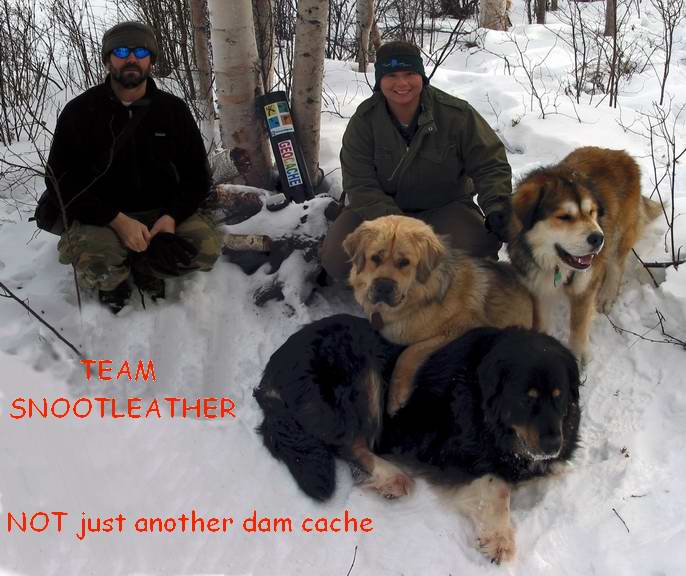
We just started geocaching this last weekend and couldnt imaging going without the whole team.
Here is a pic with out first find!
-
Edit: This topic is now closed. Thanks to those that have posted with a yea or nea. Special thanks those that couldnt follow the instructions and had to continually add some sort of comment
 when all I was looking for was a yes/no
-
Exgint,
With my handheld I have seen as good as 1 m accuracy, but usually 3-5m. Gets worse with heavy tree cover, etc.
Not sure if you knew this but I thought I would bring it up.
quoted from the U of Calgary
The accuracy of navigation systems using very low frequency signals depends on accurately knowing the altitude of the ionosphere's lower boundary. During a geomagnetic storm the altitude of the ionosphere's lower boundary of the ionosphere changes rapidly and can introduced errors of several kilometers.
Global Position System (GPS) operates by transmitting radio waves from satellites to the ground, aircraft or other satellites and therefore is sensitive to ionospheric changes due to geomagnetic storms.
Another regarding navigation
http://www.sec.noaa.gov/info/Navigation.pdf
I'm not sure how much it affects hand held units(I suspect similarly), but when ever we are planning on doing a GPS survey (mm accuracy) we always check the space weather sites to see if there are storms predicted.
this site has the article listed above plus links and info about space weather.
-
Let me clarify that Indy... no PAVED roads. there is a bumpy dirt road, but 4x4 is not needed. I made it there in January with no problem in 2 wheel drive.
-
Edit: Thanks to those that have posted with a yea or nea, but its starting to get a little out of hand. If the remainder of the comments could be a yes/no I would appreciate it.
I don't want to get caught up in the virtual argument right now, and if the polls were working I would utilize them to avoid the long winded arguments. With that said, would you visit this Virtual cache if you were in the area?
This site exists in a remote portion of the country with no paved roads for 25 miles and no geocaches within 30 miles. Imagine a vast, arid, high desert Plateau with few interesting features... Until you find this location. An oasis in the middle of no-where. A pool to soak your tired bones in... This is the location, right smack dab in the middle of the pool. "the reward for this cache is the location"!
As for "WOW" factor, its a clothing optional location(thanks Evil Rooster, I had not thought of that). But, please be respectful of others that may venture in and prefer swimwear.
Of course there will be questions to answer and historical facts to be learned.
Read below and it will explain why I choose to submit this as a virtual.
"Readers Digest" version of the guidelines that are met:
A virtual cache is a cache that exists in a form of a permanent object
at a location that was already there. Typically, the cache “hider”
creates a virtual cache at a location where physical caches are not
permitted. The reward for these caches is the location itself and
sharing information about your visit.
1) The site for my virtual cache exists in the form of a permanent object(hot springs).The BLM is currently conducting sensitivity studies in the area and while they dont mind people visiting the hot springs, camping, hiking, hunting or what ever, they would rather people dont leave things lying around.
Edit: I guess I need to clarify one issue. The area undergoing the study is an area that covers over 5 million acres, its not an easy task to place a physical cache a mile or two away.
Prior to considering a virtual cache, you must have given consideration
to the question “why couldn’t a microcache or multi-cache be placed
there?” Physical caches have priority, so please consider adding a
micro or making the location a step in an offset or multi-stage cache
with the physical cache placed in an area that is appropriate.
2) Why no physical, micro or multi cache? Due to the sensitivity study in the area.
A trail is a trail, a beach is a beach, a view is a view; but a
trail/beach/view is NOT a virtual cache. A cache has to be a specific
distinct GPS target - not something large like a mountain top or a park,
however special those locations are.
3)This is a very distinct GPS target. It is a 12 ft diameter natural hotsprings and if our GPS read the same, the coords should land you smackdab in the middle of the thing... Which is the point of the cache, to get in, test the water, report the temp or a picture of someone enjoying the experience.


Please vote on your favorite GPS for GeoCaching
in GPS technology and devices
Posted
I started Geocaching with a Garmin GPSMap 76s, until it was stolen
So, I bought the 76CS and love it even more!!!