


LSUFan
-
Posts
656 -
Joined
-
Last visited
Posts posted by LSUFan
-
-
Just looking for a few good people to cache with. I live in West Monroe, Louisiana. So anywhere close to here is good with me...I am up to traveling when it comes to caching, just looking for people relatively close to me....I have been out of the loop for about 2 years with a cache here and there but nothing serious and I am ITCHING to get back out there and cache. I was a Caching Machine for about 2 1/2 years than just started piddling out.
This area is new to me and my husband does not want me caching alone...To many dangers of the poisonous kind and he does not have the time to go with me..I started caching in Arizona moved to Minnesota, than down to New Orleans and Mississippi and finally here to West Monroe. My husband is a little worried about the poisonous factor here and I am the type to just GO, GO, GO and not think... Anyone want to get together and show me the ropes so I won't end up dying would be wonderful! I think this state is beautiful in it's own right and I am ready to explore, just looking for someone to cache with. Email me at lisa@twincitytrolleys.com
Howdy Flaggal, West Monroe just happens to be geocache central for the North Louisiana Geocachers. We try to meet for lunch Saturdays at Logan's Steakhouse on Constitution Drive. It's an open invitation to any/all geocachers. More details are on the home page of the link below.
We also do a lot of camping together at the local state parks (Lake Darbonne, Jimmie Davis), as well as getting together for other events. We will all be grilling and hanging out together at the Twin City Mardis Gras parade February 15th.
Here is the a link to our website:
www.nelageo.net
Looking forward to meeting you.
-
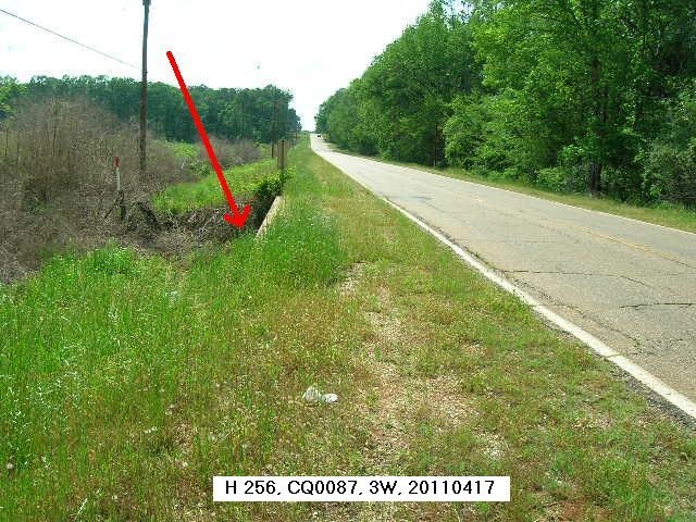
Using Google Earth I measure the bridge at 742.32 ft. or 0.14 miles long which is more than twice the distance “from the bridge to the mark”. So it would seem the center of the bridge is not the point measured from.
Did you get a GPS location for the mark?
Yes, I got Handheld coords but can't seem to find my notebook currently with them that I wrote them in. I was camping with friends at the time, and the pad may be in my RV. I'll go thru it more this evening and try to find it.
The mark is a whole lot closer to the SW corner of the SE end of the bridge than what it currently shows with the scaled coords.
Thanks for the bridge measurements.
-
IMO the mileage is not precise enough to convert it to feet, its a approximate.
Since it not stated in the description, where the mileage was taken from is unknown. It could be from anywhere on the bridge, if they would have measured it I think they would have stated where from.
IMO
Thanks Z15, it does make more sense as an approximate, but I still was wondering if there is any sort of set rules as to where the approximation was set from if not listed in the description. This was a first for me.
I will be back by there New Years Day, and besides the handheld coords I have now, I may take some better approximate measurements off the SE 'end' of the bridge to add to the description for my recovery report submittal.
This mark is located on one of those roads with a bunch of others that show up white (no reports) on Scaredy Cats viewer.........and you just have to go see if you can change their status color. LOL
-
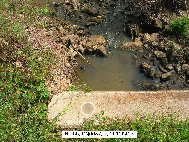
Hi everyone, I was able to get a little year-end benchmarking done today and ran into something at CQ1152 I don't guess I have encountered before. I was hoping ya could educate me for future reference, and ask for your shared wisdom.
http://www.ngs.noaa.gov/cgi-bin/ds_mark.prl?PidBox=CQ1152
The description for CQ1152 states the following:
IT IS 0.05 MILE SOUTHEAST OF THE BAYOU DARBONNE BRIDGE,
The measurement taken from the bridge states that the mark is 0.05 miles (or 264 feet).
My question is, if there is no point given in the description of where the measurement is taken from on the bridge (ie SE abutment, etc), is it standard practice for the measurement to be taken from the middle of the bridge?
We took a first measurement off the closest end of the bridge (which is a fairly long bridge). After an unsuccessful search utilizing the measurements from the main road and the bridge estimate..........I was luckily able to spot a witness post (you just got to love them) several hundred feet from our initial point of search. From where the mark was, the measurement would have had to be taken from the middle of the bridge to be 264 feet, as we weren't even close taking a measurement from the end.
I couldn't confirm the actual 264 feet measurement from the centerpoint due to the length of the bridge and dangerous traffic conditions, but it looked real close just eyeballing it.
As I stated, I don't guess I have had this pop up before in my searches, as the measurements are usually from an end or an abutment on bridges.....and was just wondering if this is something standard. If so, is the measurement taken from the exact center of the bridge?
Thanks in advance for any help.
Bobby
-
The benchmark in question came from southern California. Thanks for the responses.
Thank you, that's what we needed. The mark was reported destroyed back in 1973, and is not in the active NGS database, but you can still find it in the destroyed marks list. Probably no harm in just keeping it, but I personally can't actually give you government property. Here is the datasheet for it:
NOTE - The station below is destroyed.
1 National Geodetic Survey, Retrieval Date = OCTOBER 24, 2013
EW3769 ***********************************************************************
EW3769 DESIGNATION - V 1042
EW3769 PID - EW3769
EW3769 STATE/COUNTY- CA/SANTA BARBARA
EW3769 COUNTRY - US
EW3769 USGS QUAD - GOLETA (1988)
EW3769
EW3769 *CURRENT SURVEY CONTROL
EW3769 ______________________________________________________________________
EW3769* NAD 83(1986) POSITION- 34 26 30. (N) 119 47 21. (W) SCALED
EW3769* NAVD 88 ORTHO HEIGHT - 28.73 (+/-2cm) 94.3 (feet) VERTCON
EW3769 ______________________________________________________________________
EW3769 GEOID HEIGHT - -35.61 (meters) GEOID12A
EW3769 VERT ORDER - FIRST CLASS I (See Below)
EW3769
EW3769.The horizontal coordinates were scaled from a topographic map and have
EW3769.an estimated accuracy of +/- 6 seconds.
EW3769.
EW3769.The NAVD 88 height was computed by applying the VERTCON shift value to
EW3769.the NGVD 29 height (displayed under SUPERSEDED SURVEY CONTROL.)
EW3769
EW3769.The vertical order pertains to the NGVD 29 superseded value.
EW3769
EW3769; North East Units Estimated Accuracy
EW3769;SPC CA 5 - 605,920. 1,835,590. MT (+/- 180 meters Scaled)
EW3769
EW3769 SUPERSEDED SURVEY CONTROL
EW3769
EW3769 NGVD 29 (??/??/92) 27.944 (m) 91.68 (f) ADJ UNCH 1 1
EW3769
EW3769.Superseded values are not recommended for survey control.
EW3769
EW3769.NGS no longer adjusts projects to the NAD 27 or NGVD 29 datums.
EW3769.See file dsdata.txt to determine how the superseded data were derived.
EW3769
EW3769_U.S. NATIONAL GRID SPATIAL ADDRESS: 11SKU437146(NAD 83)
EW3769
EW3769_MARKER: DB = BENCH MARK DISK
EW3769_SETTING: 0 = UNSPECIFIED SETTING
EW3769_STAMPING: V 1042 1960
EW3769_STABILITY: D = MARK OF QUESTIONABLE OR UNKNOWN STABILITY
EW3769
EW3769 HISTORY - Date Condition Report By
EW3769 HISTORY - 1960 MONUMENTED CGS
EW3769 HISTORY - 1970 GOOD NGS
EW3769 HISTORY - 1973 DESTROYED NGS
EW3769
EW3769 STATION DESCRIPTION
EW3769
EW3769'DESCRIBED BY NATIONAL GEODETIC SURVEY 1970
EW3769'1.8 MI E FROM GOLETA.
EW3769'1.85 MILES EAST ALONG THE SOUTHERN PACIFIC RAILROAD FROM THE
EW3769'STATION AT GOLETA, AT TURNPIKE ROAD OVERPASS, 14.2 FEET NORTH
EW3769'OF THE NORTH RAIL, IN THE TOP AND 2.2 FEET EAST OF THE WEST
EW3769'END OF THE CONCRETE FOUNDATION OF A FORMER OVERPASS, 18.4 FEET
EW3769'SOUTH OF THE SOUTHWEST CORNER OF THE WEST COLUMN IN THE FIRST
EW3769'BENT NORTH OF THE TRACK OF THE PRESENT OVERPASS, 6 FEET EAST OF
EW3769'A POINT DIRECTLY UNDER THE WEST EDGE OF THE OVERPASS, AND ABOUT
EW3769'LEVEL WITH THE TRACK.
EW3769
EW3769 STATION RECOVERY (1973)
EW3769
EW3769'RECOVERY NOTE BY NATIONAL GEODETIC SURVEY 1973
EW3769'SURFACE MARK REPORTED DESTROYED.
-
I have come into possession of a US C&GS benchmark that has been removed from it's original location. No, I didn't remove it....someone else did. My father would have killed me if I had..........he was a forest ranger in his younger years. I would enclose a picture of it but don't see a way to attach one. It has the following markings V1042 and below that 1960. Can anyone tell me where it is from and what should I do with it? Thanks.
It might help if you could tell what state this disk is from (if known). I tried to look at your profile to see if I could figure out which state you geocache in, but couldn't find where you had reported anything, and could only find this one forum post for that account name.
-
Guys,
As a benefit of some data mining I did last year, I have .dat files of datasheets for the entire US and US territories that were extracted in August 2012 (August 2013 for MD) that you can work with in 'offline mode' in DSWorld. If you let me know what state you want, I can post them on my church ftp site.
I have also posted an updated DSWorld.exe and DSWorld.chm on the same site that includes mechanisms for editing photos and HH positions in offline mode with datasheet files.
I won't be able to post data to the NGS database until the shutdown is over, but the nos ftp site is still up and running, so you can submit your photos, HH positions, and recovery notes now.
My church ftp site is:
ftp://comediscoverwithus.com/Public/
Download the .dat file and put it in a folder on your hard drive. Then start DSWorld and click 'Work Offline'. Then open a state .dat file and split it. Then open a resulting county .dat file. Then you can view, print, etc. You can also export a .kml and then open it with google earth.
Send me an email if you want me to post your state:
marchershee@gmail.com
Thanks Malcolm. I really appreciate all you do for us. I have some pics that I may upload.
-
Thanks Dave, for the explanation. I can vouch for myself and did not know that about the datasheets and also thought they were filled with static information. It makes more sense now and I always did wonder how often the information would be updated to particular benchmarks, especially the ones here in Louisiana that are sinking somewhat. It makes so much more sense now, thanks to you.
Not to get into any political subject, I am a member of a camping/travel trailer forum and we have some very upset members who had to vacate the national parks. One of the other members made a humorous comment on that forum, that really summed it up and could also apply here. Maybe all the govt websites need to have it on their page........as quoted from one of my favorite movies.
"Sorry folks, park's closed. Moose out front shoulda told ya. "

-
I am envious. The only thing I find over the marks down here is dirt........or mud.
-
There are even ways to download all the datasheets for each state and convert them over to poi's to put in GPS units like a Garmin Nuvi. I have every NGS bluebooked benchmark loaded for three states in my Nuvi and if I come within 500 feet of one while driving, I get an alarm to let me know.....and also have the entire datasheet at my fingertips.
Once you get into the hobby, you may find you enjoy it more than geocaching.
Come over to the mark side.

-
I've read all the information about the benchmarks, and have found a few. My biggest difficulty is that unlike geocaches, where I can pull up a map, look at the location, plan my route, and refer to the description/hints in the field, benchmarks are tedious to look up and it is very difficult to reference information in the field. I really think that if we could access this information more readily, more people would find benchmarks.
There are other places to get NGS benchmark information (mostly written by fellow benchmarkers)......like what you described.
When you are sitting at a computer:
http://benchmarks.scaredycatfilms.com/
Downloadable DSWorld free from the NGS:
http://www.ngs.noaa.gov/PC_PROD/PARTNERS/
Phone apps:
Benchmap for android:
http://www.appbrain.com/app/benchmap/com.tsqmadness.bmmaps
Findmarkers for iphone:
Sorry, no link but it should be in the store
-
http://www.geocaching.com/mark/nearest.aspx'>http://www.geocaching.com/mark/nearest.aspx
Thanks. I took a peek at your linked page and still failed to identify the marker I saw recently. It was located southwest of Attica, OH just east of State Route 4 and immediately adjacent to geocache #GC1V2QJ "Blink and you will miss this one!" I failed to note the name of the local road but it likely was Township Road 44. The coords for that cache are N 41 02.236 and W 082 53.996. The local Zip code is 44807. The marker was a USCGS disc secured to a slightly eroded, concrete monument about a foot square and the unique inscription was "Roadside #2 1959" with an inscribed symbol looking like an arrow with a short cross mark centered on the arrow's shaft and pointing generally WNW. All other information on the disc was that routinely cast in such discs.
What you found was Reference mark #2 placed in 1959, that the arrow points to the triangulation station named "Roadside" with an identifier/PID of MC1198. The datasheet for triangulation station MC1198 will also have the descriptions for it's reference marks and azimuth marks listed on it.
This link will help explain what exactly a triangulation station is....as well as the reference marks and azimuth marks that go to the triangulation stations.
http://forums.Groundspeak.com/GC/index.php?showtopic=185361
If you will read the logs for the station "Roadside" you will find where there have been many recoveries (the technical term for discovering/logging benchmarks) that have pics of the reference marks, including the one you found. However, a lot of the time, reference marks will not have their own loggable identifier number/PID, and are basically just a subset of the main station, which is MC1198. The main station mark is what you must find to successfully (and accurately) log MC1198...............and NOT the reference marks.
http://www.geocaching.com/mark/details.aspx?PID=MC1198'>http://www.geocaching.com/mark/details.aspx?PID=MC1198
The log by Sprinterman was the ONLY one that I saw that was correct. He found the true station MC1198 and then it's two reference marks and one azimuth mark. Here is his pic of the actual MC1198.
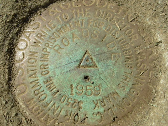
If you will read the original datasheet below for station MC1198, it will have what is called a box score in it. This box shows you the distance and directions from the actual station mark to the reference marks, and other.You will read that reference mark 2 is located 40.495 meters from the station disk at a direction of 114 degrees 43 minutes. You will also notice there is no loggable PID for the reference marks or azimuth mark, as we discussed above.
http://www.geocaching.com/mark/datasheet.aspx?PID=MC1198'>http://www.geocaching.com/mark/datasheet.aspx?PID=MC1198
Since you know where reference mark 2 is, you can do what is called a reverse azimuth. You would basically walk at a compass direction of 295 degrees (115 degrees + 180 degrees) for 40.495 meters (basically 133 feet) and would be at the true station MC1198. If the reference mark has been oriented as it should be (they do make mistakes sometimes though), the arrow on reference mark 2 will point to MC1198. Triangulation stations have adjusted gps coordinates (which mean they are much more accurate than your handheld gps unit is) and you can also use the gps coordinates to find the main station mark too.
Most benchmarks have "scaled" gps coordinates, which can be off by 600 feet or more. A triangulation station has "adjusted" coordinates which are highly accurate.
Hopefully, you will find as much fun in benchmarking as many of us do. Triangulation stations with all of it's corresponding reference marks and azimuth marks, are my favorite kind to find.
A good place to start learning about benchmarking, and the different kinds of benchmarks is here in the FAQ section:
http://www.geocaching.com/mark/
This was taken from the FAQ link above, that helps explain reference marks like you found:
Reference Marks
Triangulation stations usually have two or more reference marks associated with them. Reference marks are for helping to keep the location of triangulation stations from being lost and are not actually geodetic control marks. The triangulation station's description has accurate azimuth and horizontal (not slope) distance to each of its reference marks so that it can be re-set from them if necessary. These marks also have arrows in their centers that are supposed to point toward the triangulation station. A few reference marks are surveyed with adjusted coordinates and have their own PID in the database.
-
2oldfarts - Be assured that your efforts to provided updated hand-held positions for bench marks with very poor scaled values is not in vain. While I am retired from NGS I do have connections that allow me to update the NGS database that are not available to the general public. Whenever someone submits an HH position to update a scaled value before it goes into the NGS database they run a checking program and anything that shows up as being different by more than 10 seconds of latitude and/or longitude gets flagged for checking. Whenever I harvest positions from this site to update I automatically check to see if they meet that standard. In the case of those such as yours I check your updated position with the description to see that they match. If they do, which they certainly do in your case, then I sent them to a contact at NGS who knows that I perform these checks so they get updated automatically.
Thanks for the the clarification and for still helping out in your retirement, DaveD.
I submitted (thru DSWorld) a recovery the other day on CQ0977, and the photos and updated HandHeld 2 coordinates were posted to it's datasheet very quickly.
-
If we do go, we will report what we find in this thread.
John
Please do. You know how we all like these peculiarities/mysteries.
-
Those are some awesome pictures. I am jealous.
I am also curious as to what that U 151 mark is, that shows up between D 151 and E 151 on your maps. I am understanding your point being that the marks were way off the posted coordinates, but surely the "U" mark of the 151 level line series couldn't have been that far off.............or was it? If so, it appears that something got messed up somewhere.....even more so than the rest.

EDIT: After glancing at the marks coordinates in DSWorld (which you are supposed to be able to send coordinate corrections into NGS with) here is what is they have for the marks. DSWorld's google earths mapping show U 151 in the same spot as your maps do. :
S 151 is N37 07 59 W111 17 01
T 151 is N37 07 52 W111 16 47
U 151 is N37 07 35 W111 25 23
V 151 is N37 08 04 W111 16 06
W 151 is N37 08 05 W111 15 37
It appears someone may have possibly entered in some wrong numbers in the West minutes for U 151. Looking at the natural progression, it may have supposed to have been 16 minutes (not 25 minutes). Probably just a keyboard entry typo when they were making the online database. If so, they missed by a lot more than a mile on that one.
-
73Rebel has a real fun one down here in north Louisiana.
-
It is still fun to find these bits of history........
Absolutely. I personally like any/all historical items.
I kind of have a keen interest with the Bilby Towers, and you never know if someone may stumble across something like one in their travels. One of the few remaining was located down here in my neck of the woods, but as Bill pointed out last year, it was being relocated to Bilby's hometown.
This will be my last comment on the subject here as I don't want to totally hijack Shirleys post.
Youtube video of it's removal:
I figured someone would have snapped/submitted some pics of the station mark (AU2876) and reference marks while they were taking down the tower......but I guess they had other priorities.
-
This one was a hike and then the mark was found by our friend after moving several large rocks close to an old bilby tower.
Shirley~
~~~~~~~~~~~~~~~~~~~~~~~~~~~~~~~~~~~~~~
Shirley, that was a great find. You didn't happen to take any pics of the old Bilby Tower, did you?
-
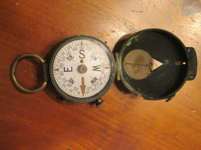
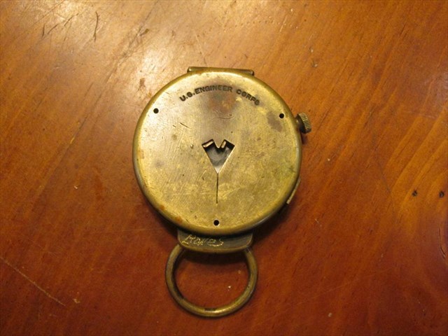
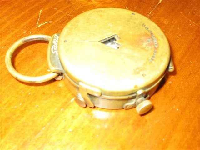
A geocaching(and benchmarking) friend of mine who works for a small towns public works dept. found this compass, where someone had thrown it away. He gave it to me, and after a little research it appears it is from the World War I era.
Here are some pics of the compass and what I found on the internet about these kind. I may donate it to our local military museum, as I have several other items.
I though ya might enjoy seeing it, and I would welcome any information about these. It is engraved Cruchon & Emons, Berne on the back and US Engineer Corps on the top. To be nearly 100 years old, it still works.
As I said in the title, it's something a benchmarker can appreciate.
http://compassmuseum.com/hand/hand_2.htm#C-E
This is an EXCEPTIONALLY well made compass, machined from a solid block of brass with a jeweled rotor with the original very early radium paint treatment on the cover and dial.
It has a rotor lifter button (at SE) that is automatically engaged when the lid is closed for carry. It also has a separate button to damp the motion of the rotor (a tiny pin at NW). There is a bezel lock thumbscrew at NE that engages a brass detent ring on the crystal.
The cover is hinged and serial numbered to match the base. There is a brass area designed to be polished to mirror brightness to read the bearing at eye level.
The rotor dial is numbered conventionally (360 degrees) and there is a mirror-image (reversed) numbers to be read in the mirror on the lid. The lid snaps shut crisply and stays closed in carry.
This is an outstanding piece of engineering with a lot of attention paid to the details that are obvious in the close-up image of the face.
It measures 2-1/8 inches in diameter..
Makers marks can be seen on this view of the back. It is marked U.S. Engineer Corps (NOT Corps of Engineers) on the top.
It is calibrated on the 20s with major indices on the 10s and minor indices on the 5s. Cardinal points are indicated by a large radium arrow (for N)-E-S-W (with smaller radium arrows) and letters and NE-SE-SW-NW for the 8ths.
-
Looks and works great. I appreciate all you do for us. Thanks so much.
-
Am I right in reasoning these two markers are in holes drilled into busy roadways? The datasheet cords appear to be off vs. the descriptions.
TU0915 I think is in the middle of a highway here vs. in a field (I think the cords are pointing to a rockpile in the middle of the field here).
TU0857 appears to be in the middle of an intersection instead of somewhere here.
Both of these marks have scaled coordinates (which can be off by 600+ feet from the actual location). If/When you do find these marks, make sure to take gps readings and submit these new coordinates as Handheld 2 numbers in your logs. This will make the coordinates accurate to 15-30 feet, which is a lot better than 600+ feet.
Here is the explanation of scaled vs adjusted coordinates on datasheets:
What is the difference between "Location Adjusted" and "Location Scaled?"
Simply put, "location adjusted" means that the published coordinates are very accurate, and "location scaled" means that the published coordinates are not very accurate. The published positions for benchmarks with adjusted horizontal coordinates were computed using advanced surveying techniques and are far more accurate than even the finest handheld GPSr can get. The position of a benchmark with "scaled" coordinates was derived by a human in an office by estimating the location of the mark on a topographic map with a scale (ruler). As such, they can be off by 600 feet or more from the actual position though deviations in the 100 - 150 foot range are more common. Your handheld GPS may be very helpful in finding benchmarks with adjusted horizontal coordinates, but can be nearly useless for finding benchmarks with scaled horizontal coordinates. The good news is that only vertical control points have scaled horizontal coordinates. Trying to use your GPS "GOTO" function to find a benchmark with scaled horizontal coordinates will usually lead to frustration and failure.
How can I determine whether a particular mark is "Location Adjusted" or "Location Scaled?"
On a Geocaching benchmark datasheet, the second line under the coordinates will say either "location is ADJUSTED" or "location is SCALED".
On the 9th line of an NGS benchmark datasheet, to the right of the latitude and longitude coordinates, will be either the word ADJUSTED or the word SCALED. (Don't confuse this with the next line down, which tells whether the vertical elevation is adjusted or scaled.)
I have copied/compiled a lot of info from these forums and posted it in a local geocaching forum, that explains adjusted, scaled, and Handheld 2 coordinate numbers you may encounter on datasheets. It also explains the difference between the horizontal and vertical datum on the datasheets and not to get them confused. It is at the link below:
http://www.nelageo.net/index.php?option=com_kunena&func=view&catid=13&id=10956&Itemid=54
TU0915 is on the headwall, of the culvert. If this is still the same road and culvert, the disk is most likely near the edge of the headwall, which would not be in the road but to the side of it. Probably something similar to this:
TU0915_MARKER: DV = VERTICAL CONTROL DISK
TU0915_SETTING: 32 = SET IN A RETAINING WALL OR CONCRETE LEDGE
TU0915_SP_SET: CULVERT HEADWALL ON LAVA FLOW
TU0915_STAMPING: B 24 1979
TU0915_MARK LOGO: NGS
TU0915_MAGNETIC: N = NO MAGNETIC MATERIAL
TU0915_STABILITY: C = MAY HOLD, BUT OF TYPE COMMONLY SUBJECT TO
TU0915+STABILITY: SURFACE MOTION
TU0915
TU0915 HISTORY - Date Condition Report By
TU0915 HISTORY - 1979 MONUMENTED NGS
TU0915
TU0915 STATION DESCRIPTION
TU0915
TU0915'DESCRIBED BY NATIONAL GEODETIC SURVEY 1979 (WVM)
TU0915'1.6 MILES NORTH ALONG STATE HIGHWAY 37 FROM THE JUNCTION OF STATE
TU0915'HIGHWAY 400 IN PUKALANI, SET IN TOP CENTER OF THE EAST CONCRETE
TU0915'HEADWALL OF A BOX CULVERT, 27 FEET EAST OF THE CENTER OF THE HIGHWAY.
TU0857_MARKER: DV = VERTICAL CONTROL DISK
TU0857_SETTING: 32 = SET IN A RETAINING WALL OR CONCRETE LEDGE
TU0857_SP_SET: HEADWALL
TU0857_STAMPING: H 22 1979
TU0857_MARK LOGO: NGS
TU0857_MAGNETIC: N = NO MAGNETIC MATERIAL
TU0857_STABILITY: C = MAY HOLD, BUT OF TYPE COMMONLY SUBJECT TO
TU0857+STABILITY: SURFACE MOTION
TU0857
TU0857 HISTORY - Date Condition Report By
TU0857 HISTORY - 1979 MONUMENTED NGS
TU0857
TU0857 STATION DESCRIPTION
TU0857
TU0857'DESCRIBED BY NATIONAL GEODETIC SURVEY 1979 (WVM)
TU0857'0.8 MILE NORTH OF PUUNENE, AT THE JUNCTION OF STATE HIGHWAYS 35 AND
TU0857'STATE HIGHWAY 38, 38 FEET WEST OF THE CENTER OF STATE HIGHWAY 35, 21
TU0857'FEET SOUTHWEST OF MILE POST 1, 100 FEET NORTH OF THE CENTER OF STATE
TU0857'HIGHWAY 38, AND 25 FEET NORTHEAST OF UTILITY POLE NUMBER 147T.
-
Being this is a USGS mark, you can contact their office. They will actually go to their file cabinet and get out the original documentation for the mark, to send you a copy. That way you can see if their reference mark description is different from what the NGS keyed into their online database.
The following was taken from the USGS website:
How can I find survey benchmark information?
Depending on what survey benchmark information you're looking for will determine where to look. Most survey benchmarks were not established by the U.S. Geological Survey, but, instead by the National Geodetic Survey, and are available on their website at www.ngs.noaa.gov. From there, click on the "Datasheets" link at the top of the page and navigate the subsequent retrieval links. If you need further assistance you can call 301-713-3242 or e-mail infocenter@ngs.noaa.gov.
As for USGS survey benchmark data, this is not yet available online. However, you can still inquire about the USGS benchmark information from two sources. For the Eastern U.S. vertical and horizontal control information contact the USGS in Rolla, Missouri, by calling 573-308-3500 or e-mailing mcmcesic@usgs.gov. For Western U.S. vertical and horizontal control information, contact the USGS in Denver, Colorado, by telephone at 303-202-4400 or by e-mail at infoservices@usgs.gov.
-
What I used to plot the Ref marks was Expert GPS by Topografix. I took the original data sheet coordinates for KMO444 and input the Bearing and Distance for each Ref mark and EGPS then projected a new waypoint FROM the KMO444 location TO the "supposed" Ref mark location.
The data sheet clearly states or "says".....the Ref marks are.. FROM the station NORTH 29/25 deg X min E/W... 59/50 ft.
....yet when plotted to actual coordinates Both are "physically" SOUTH of KMO444.
I know my coordinates (and yours) are "accurate" (for a GPS) for the actual Ref mark locations.
It's just that I think the verbage describing their locations is incorrect.
I'll work with the programs you referenced this afternoon. Maybe it will become clearer then.
Thanks.
OK, I think I misread what EdrickV did. It appears he took the posted coordinate numbers, and then got the bearings for them from the station. That makes sense on why the gps numbers were too perfect.
I'll look at the datasheet and see what I can make from it. Yes, there are sometimes error in the datasheets (which you may very well have), as well as numbers getting transcribed wrong when the datasheets were keyed into a computer. I have found some marks listed in the wrong county as well as the wrong state.
-
Using the coordinates for the main station and RM1 in Inverse you get the following:
 Ellipsoid : GRS80 / WGS84  (NAD83)
 Equatorial axis,    a   =    6378137.0000
 Polar axis,         b   =    6356752.3141
 Inverse flattening, 1/f =  298.25722210088

  First  Station :
  ----------------
   LAT =  39  5 13.48983 North
   LON = 108 43 57.62473 West

  Second Station :
  ----------------
   LAT =  39  5 13.60000 North
   LON = 108 43 58.50000 West

 Forward azimuth        FAZ = 279 10 28.5064 From North
 Back azimuth           BAZ =  99 10 27.9546 From North
 Ellipsoidal distance     S =        21.3083 m
And the results for RM2:
 Ellipsoid : GRS80 / WGS84  (NAD83)
 Equatorial axis,    a   =    6378137.0000
 Polar axis,         b   =    6356752.3141
 Inverse flattening, 1/f =  298.25722210088

  First  Station :
  ----------------
   LAT =  39  5 13.48983 North
   LON = 108 43 57.62473 West

  Second Station :
  ----------------
   LAT =  39  5 13.20000 North
   LON = 108 43 57.30000 West

 Forward azimuth        FAZ = 138 52 22.7606 From North
 Back azimuth           BAZ = 318 52 22.9653 From North
 Ellipsoidal distance     S =        11.8656 m
Not totally sure I know how to use Forward, so I'll skip that one. Since this mark doesn't have a proper box score, DSWorld's compute RM position function won't work on it. (Same for NGS>GPX I think.)
Good deal EdrickV. When you take the numbers you posted after running the INVERSE, then converting the degree,min, sec format to decimal minutes......the numbers come up to be (as I always just take the seconds and divide by sixty to get decimal minutes)
RM 1- 39 05.22666 (or .227 rounded), -108 43.975
RM 2- 39 05.220, -108 43.955
These numbers almost match exactly the numbers posted by the geocaching logger and Grasscatchers actual gps numbers (which handheld gps isn't usually that accurate).

So GrassCatcher, it appears that something may have been amiss in your original plotting of the reference marks.


Highest Elevation in Monroe, LA and West Monroe, LA
in Benchmarking
Posted · Edited by LSUFan
Travis, I am an avid benchmarker and reside in West Monroe. I can probably answer that question, depending on what it is your really looking for.
Are you wanting known benchmarks in the city limits, or general area? Are you also looking for true elevation benchmarks (not intersection stations or such)?
Are you looking for benchmarks that are in the National Spatial Reference System (NGS marks)?
I have all the NGS marks loaded into GSAK and am able to filter by elevation to ascertain the info.