


Capt. Bob
-
Posts
151 -
Joined
-
Last visited
Posts posted by Capt. Bob
-
-
On 1/16/2024 at 11:52 PM, barefootjeff said:
That looks to have been sufficient, as the CO has just updated their coordinates. Yay!
Pythagorean’ Theorem, A2 + B2 = C2 is a machine. Enter values for A & B and it precisely calculates the result for C, but it may be not accurate!
Accuracy depends on the user who must enter the correct data and know how to do math!
-
I believe most people who use Smartphones do not know how the GPS system works… they think it’s magic. As long as it can navigate them to a restaurant, that's good enough. However, finding a micro in the woods relies on two factors i.e. the skill of the cache owner plus the skill of the cache seeker. Skill only comes from knowledge and practice.
Maybe a certification program should be enabled by TPTB with a “License to Cache” issued! The license has two levels: The Right to Find, and The Right to Hide. (A framed certificate of competency would be a nice touch!)
-
.png) 3
3
-
 1
1
-
-
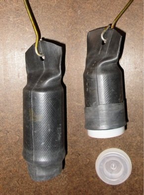
I agree with the previous responses that mint tins are a PITA. The best alternative is a plastic container. Consider the following when using a magnet for mounting.
The magnet should be a flat, round, as big as possible and mounted inside the container. The strength of the magnet should only be enough to secure the container and its contents to minimize stressing when removing the case.
The plastic surfaces should be cleaned with alcohol to remove contaminates (mold release, oils, etc.) then either rough or lightly flame treat (not melt) the plastic to break surface molecules bonds (also a good idea before applying paint).
The thermal coefficient of expansion of plastic is several orders of magnitude greater than the magnet. So to mitigate stresses during temperature cycles the magnet should be attached with an adhesive that forms a flexible bond (like marine grade 3M 5200 Adhesive Sealant that offers both good cohesion and adhesion). When applying the adhesive leave a thin layer of adhesive between mating surfaces to allow for expansion.
Remember that plastic cases are organic and are susceptible to the environment, such as sun light (UV), ozone, freezing temperatures, gnawing critters and, worse of all, humans. Anything you can do to mitigate these other factors will enhance the container’s existence and reduce your maintenance.
-
1
-
2
-
-
The algorithm used to convert signals into useable data is pretty much the same for all devices. What isn't the same is the way the signal is collected, meaning the antenna. The physics of antennas is such that the bigger the antenna the better. Hand held GPSr's have larger antennas than smart phones. Phones are designed by marketing managers where fashion is as important as function...fashion sells.
-
5
-
1
-
-
Glad it worked out for you. BTW, what firmware are you using? If you are not using 3.7, or your PN60's date is wrong, you should update your firmware from here: https://support.garmin.com/en-US/?faq=dXCDWk3aIZ3A0Ly9z8uym5&productID=585533&searchQuery=firmware&tab=topics
-
1. On Geocaching.com main page select the "Play" menu, then select "Pocket Queries". Create a new query using the form provided and name it.
2. Once new query is displayed on the list, select it and download it to your computer.
3. Move the down loaded folder to the desk top and open it.
4. You will see two files, a "ABCD.gpx" and a "ABCD-wpt.gpx". The ".gpx" file has the cache details and the "-wpt.gpx" has associated waypoints (like parking, trailhead, etc.)
5. Fire up your Delorme PN-60. On first display page select "Settings", then "Connect to Computer".
6. When connected select "Use GPS". Select either "Open SD Card" or "Open Internal Drive" (I prefer the SD Card).
7. A new page will popup on you computer screen. It will be the SD Card named "PN60(D)"
8. Drag and drop the two GPX files into the "waypoints" folder displayed on the PN60(D).
9. Exit out
10. That's it! If you want to add more queries or update an old one just repeat the above. You can delete old queries just by selecting and deleting.
If this is the first query entered to the PN-60 or you have more than one query in the D drive you must select the one you want to use. So on the PN60's main page select "Geocaches", then "Menu" button.
Finally select "File...", then "Open". Select the file you want. (Before selecting "File..." make sure you are in "Switch to Show Not Logged Caches")
Good luck
-
On 11/3/2022 at 12:42 AM, Mineral2 said:
My guess is UTC. Displayed time can be converted from UTC using Time Zone data, but I'm betting that all calculations are made using UTC.
Technically, GPS Time is the standard for the GPS system. UTC is the standard for the (physical) world. However, GPS System Time (GPST) and Coordinated Universal Time (UTC) were once the same. UTC must keep in sync with the earth’s rotation, GPST does not, so at midnight, January 6, 1980 a leap second was added to UTC due to earth’s slowing rotation rate, but GPST did not change. More leap seconds were added over time so that by September 11, 2020 GPST was ahead of UTC by 18 seconds. Part of the NAV message sent to the GPS receiver includes corrections so that both clocks (actually oscillators) are in sync.
-
1
-
-
13 hours ago, Atlas Cached said:
1. The device used by the person who captured the posted coordinates could have been 'off' by 15 feet or more, AND
2. The device used by the person searching for the geocache may also be 'off' by 15 feet or more, AND
3. ANY satellite imagery or other map used to determine what is located at the posted coordinates will ALSO be 'off' by an undisclosed distance
This all adds up to easily 30+ feet of device error under the best circumstances, and any map used may also mislead you, although unintentionally.
There is another error to consider. When converting positional error from GPSr (circular) to Map (XY) coordinates another error in introduced. The GPSr determines a waypoint’s true position with an estimated positional error (EPE) that results as a circle about a point. When expressing this waypoint using XY coordinates the result is a square bounded by the limits of the EPE. This increases the search area by 27.4%

-
.png) 1
1
-
-
While bushwhacking my way to a cache I stepped over the log and found Bambi. The little guy didn't move a muscle while I took a picture. I went off and found the cache but when I stopped by on my way back to the car the little critter was gone. (GC9VRTM)

-
1
-
.png) 5
5
-
-
Non-Volatile Memory (NVM) is a storage area that retains your data when you shut down the GPSr. It contains data regarding your last location, ephemeris, almanac and other format settings. The procedures are described here: https://support.garmin.com/en-US/?faq=4ErqMmVofk9TVOOnvCfpMA
-
Have you tried a NVM re-boot? If you have done so and still have a problem your unit may need reformatting.
-
The fourth digit displayed on a GPSr is like that sweep-second hand on an alarm clock. I mean who sets an alarm clock to 6:30:18 AM? Besides that, that little pesky hand keeps moving! Like every second it moves! Very hard to determine the correct time. Luckily, one can remove that hand and still have a very functional clock! Who needs it!
Sometime during the past century, people began to find the sweep-second hand useful and they reluctantly accepted the newfangled addition even though it was very confusing to use. As a product of last century, I too was distressed, but over time I found the sweep-second hand useful. At least it indicates the clock hasn’t stopped working, (but a digital clock that shows hours, minutes and seconds(!) is just too pretentious for me).
Seriously, I suggest you consider the fourth digit only as an indicator how precise your GPSr calculations are given the data it receives. The more frequent the fourth digit in the display fluctuates indicates how much ambient conditions are affecting the precision of its navigational solutions. But, just like a digital clock displaying seconds, it does not indicate the accuracy of the display, it displays its precision at the moment. Accuracy has its own set of problems.
Here’s an interesting article, https://blis.com/precision-matters-critical-importance-decimal-places-five-lowest-go/
-
1
-
2
-
-
From the NGS forum FAQ (https://forums.geocaching.com/GC/index.php?/topic/95774-ngs-forum-faq/)
Q. I found a mark and its LAT/LONG coordinates were way off. What is going on?
A. This is a bit technical, so please read carefully.
NGS has two different types of marks: Horizontal control marks, and Vertical control marks. The marks used for vertical (i.e. elevation) control often have a “SCALED” position. You can tell if this is the case by looking at the datasheet. A “SCALED” position means that the horizontal (LAT/LONG) coordinates were estimated using a map. In this case (and ONLY in the case), your handheld LAT/LONG coordinates are potentially more accurate than the position listed on the datasheet. In these cases you can record your GPSr coordinates for the mark and include them in the notes area of the NGS recovery form. Your coordinates will be used to help people find the mark in the future. Keep in mind that submitting handheld GPSr coordinates is totally optional. If you do chose to submit handheld coordinates you should know that NGS uses the NAD83 datum and coordinates are recorded as DD MM SS.S. Recovery reports which include GPS readings should conform to those standards.
-
To prolong the usable life of the battery it should be completely disconnected from the circuitry when not in use. A simple on/off switch would suffice but this requires humans to switch it off when finished (I find nothing destroys a cache quicker than humans). The method I use is with a normally closed reed switch with a magnet embedded in the lid and the reed switch mounted in the body of the cache. (Mouser Electronics, Part #934-MDRR-DT20-30F @ $2.50 ea.)
-
1
-
-
I use a very specific rating system when I approach a cache to decide how much ‘GZ time’ I will spend searching. I use this simple formula...
• Coefficient of CO’s experience: over 500 caches placed = 0.95, between 500 and 100 = 0.50, less than 100 = 0.05
• Cache Size (minutes): Large = 30, medium = 20, small = 10, nano = 5
• Degree of Difficulty (minutes): Challenging = 10, all others = 5
• Terrain (minutes): Water = 10, swamp = 8, briars/vines/PI = 5, P & G = 1
• Venue factor: Unique location = 2.0, just a so-so location = 1.0, boring location = 0.5, in hider’s front yard = 0.0GZ Time = Coef. Of Experience X ((Size + Difficulty + Terrain) X Venue factor)
-
4
-
-
There are only two systems of measurement, the imperial system and the socialist system.
Using the imperial system a nano sized cache would be a cubic barleycorn, a small size cache would be a cubic hand. However, using volume measurement (based on 10 pounds of distilled water equaling one gallon) a nano cache would be called a gill, small cache called a pint, medium cache called a quart and large cache called a gallon.
Not to confuse the issue, but instead of using statue miles, we should use nautical miles. It just makes more sense because it is equal to one arc minute of a great circle (aka, as-the-crow-flies). This naturally leads to using fathom as a basic unit of measurement because it equals 1/1000 of a nautical mile.
So a typical log might be written like this: “I found a barleycorn (or a gill) about 1 ½ nautical miles along the trail within 2 fathoms of the GZ.”
-
4
-
 1
1
-
1
-
-
In my state there are 16,291 geocaches. Each year MassWildlife stocks 40,000 ring-necked pheasants in Wildlife Management Areas. Geocaching is allowed in Wildlife Management Areas. Pheasants and Geocaches like hiding in the bushes. I like finding both. Pheasants taste good.

-
1
-
1
-
1
-
-
When I first started Geocaching these were popular. 35mm cans and a bicycle inner tube with a little tube repair rubber cement to seal the end. 100% water proof, long lasting and difficult to spot hanging in a tree. Those were the good old days before the god-awful nanos reared their ugly heads. You could go to any pharmacy and ask for 35mm cans and end up getting a trash bag full for free!
-
1
-
1
-
2
-
1
-
-
On 11/1/2021 at 12:19 AM, niraD said:
A film canister has a volume of 50ml or less. Containers with a volume between 50ml and 100ml should be listed as micro, but the "film canister or smaller" language implies that they should be listed as small instead.
A 35mm film canister actually measures 1.25” dia. x 2.00” high (31.8mm x 50.8mm) with a volume of 40.35ml. It gets its name because it holds a roll of 35mm wide film. So the lower limit should be changed to 40ml.
-
1
-
1
-
-
If you hold a normal compass (mine is an old Boy Scout compass) flat the arrow points to Magnetic North. You then rotate the base to point towards your waypoint to set the bearing. All works fine, but if you tilt the compass it will display corrupted information. The same could be true for GPSr units, however...
On my GPSr I display the heading arrow and the actual bearing to the next waypoint. The bearing is determined by the GPS signal, but the heading is determined by either motion (>1.5 mph) or, if no motion, magnetometers. Just like my BSA compass, tilting the GPSr will corrupt the heading unless corrected. Older GPSr used a bubble level to fix the compass’ orientation but now most GPSrs use accelerometers.
There are three accelerometers that are used to orient GPSrs by determining which way is down (center of the earth) by measuring the acceleration forces in 3-space (XYZ). Gravity is an acceleration force. Magnetometers are constantly changing as the GPSr moves through local lines of magnetic flux. Accelerometers are calibrated once (unless they become corrupted) so the GPSr knows how it is oriented. If tilted the GPSr can mathematically reorient itself to find the center of the earth.
It should be noted, magnetic compasses don’t necessarily point to Magnetic North. They align themselves to the local lines of force which generally point to Magnetic North. These lines of force are subject to local disturbances that may bend them and throw off the compass needle. -
31 minutes ago, barefootjeff said:
Maybe the location information being transmitted by the phone towers around here isn't all that accurate, but I've had a lot of trouble getting good positioning when the phone tries to use them to augment its GPS reception. Earlier in the year I was with a group doing a puzzle which required everyone to be within a certain radius of the waypoints while logged into a website that read the phone's position. The only way I could get it to work was to set the phone to use only GPS, otherwise I kept being hundreds of metres off no matter which way I went.
3 hours ago, SpiritGuide said:Not exactly true. Phones can use A-GPS (Google that) which combine GPS with triangulation and network servers that provide location data to enhance the GPS readings. It's not a cheat, but an actual improvement over dedicated GPS devices.
A-GPS is a function used to speed up the determination of position. The GPS receiver obtains Aiding-Data via a communications network like a cell tower. The data includes:
Satellite constellation (Almanac)
Precise orbital data (Ephemeris, orbits)
Time information
Doppler frequency and frequency-offset (error) of the GPS receiverWith the availability of this Aiding-Data the GPS receiver can very quickly determine position, even under poor signal conditions.
In a way it is similar to WAAS that corrects for GPS signal errors caused by:
Ionospheric disturbances
Timing errors
Satellite orbit errors
Satellite healthWAAS information is collected at various reference ground stations and transmitted to one of two geostationary satellites where it is transmitted to GPS receivers.
I don't think telephone companies can use triangulation to provide you location data. However, they can ping your telephone if they have your phone number. By timing the return time of the ping they can estimate the radial distance from their tower. Using three towers they can roughly determine your location. Usually for SAR work.
-
1
-
-
Accuracy (a relative term) is a marketing buzzword that helps to sell their product, however the GPSr is not accurate, it is precise. Accuracy relies on the quality of input data. In this case it is the signals, WAAS/EGNOS (and AGPS for phones), that improve accuracy by improving the data. In other words, don’t blame the GPSr for inaccurate solutions it only crunches numbers it receives whether from satellites or humans.
-
22 hours ago, Atlas Cached said:
Also, I always enable WAAS/EGNOS to further refine my location signal. This should always be enabled, as it will never degrade your accuracy, only improve it.
I think you are confusing accuracy with precision. WAAS/EGNOS only provides additional information on ionospheric conditions that affect the precision of your GPSr. This, when combined with the GPSr’s determined DOP (Dilution Of Precision), is displayed as an EPE (Estimated Positional Error) circle on the GPSr. The worse this combined error is the larger the EPE circle becomes. However, as long as the waypoint is within this circle you can’t say anything about the waypoint’s accuracy because it falls within the limits of precision.
If the actual waypoint falls outside of the EPE circle only then the accuracy of the coordinates can be called into question. The “machine” (precision) has done its job but the “human” (accuracy) didn’t do their job. So either the hider failed to publish good coordinates or the seeker failed to use their GPSr properly.
-
What you need is a snorkel.
-
1
-
.png)


.png)

.png)


Brute force attack on certitude
in General geocaching topics
Posted
4 factorial is 4! = 24 possible combinations
8 factorial is 8! = 40,320 possible combinations
Unfortunately, coordinates needed are 10 digits long NXX.XXX + WXX.XXX
10 factorial is 10! = 3,628,800 possible combinations