


TerraVador
-
Posts
50 -
Joined
-
Last visited
Posts posted by TerraVador
-
-
Bill,
It certainly looks to me like these are the same marks. I would email my observations to Deb Brown. In all likelyhood, the coords and NAVD(88) height for NK0783 are incorrect. She may have to dig up the original paperwork.
Rob is correct when he says leveling is path dependent. The earth is not uniformly dense. A plumb bob does not always point to the center of the earth. If I am closer to a mountain than you, what I consider to be level will actually be leaning from the mountain toward the area of lesser gravity. An error is introduced at each step. These errors do not average out even in a closed loop. The only way to eliminate error, assuming perfect instruments, would be to break the path up into infinitessimal steps.
-
You should find the AZ MARK within 1 meter N/S and a few meters E/W of of these coords:
N 37 01.994, W 86 51.776
N 37 01 59.6, W 86 51 46.6
How did I get these numbers? First, view the
TOPOZONE image:
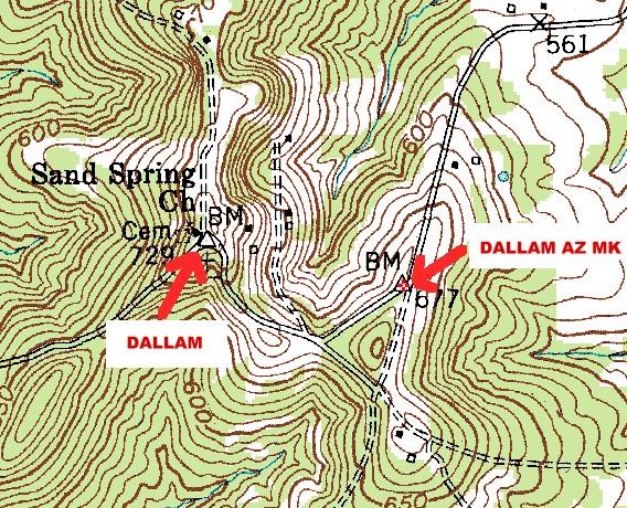
You can clearly see a BM 677 and a triangle on the map at the likely location of the azimuth mark. If you click in the center of the triangle , you get coords that are accurate to within around 5 meters much of the time. I got UTM 16W 512190E 4098563N. But we can refine the N/S position since we know that the mark is EXACTLY 102d 44m 53.2s from the main mark.
Using a program like GEOCALC, find the distance from DALLAM to DALLAM AZ MK:
DALLAM N37 02 02.79099 W086 52 04.05646
DALLAM AZ MK 16W 512190E 4098563N = N 37 01 59.48, W 86 51 46.57
Distance: 1456.485 ft
Now project a point 1456.485ft at 102d 44m 53.2s from DALLAM, and you get the new numbers for DALLAM AZ MK : N 37 01 59.6, W 86 51 46.6
Do me a favor and if you find the AZ MK, take an average GPS reading and let me know what you get for its coords. Assuming the mark has not been graded away, it should be easy to find since it projects 6 inches.
-
If for some reason the mark was not considered publishable during the time that geocachings copy of the database was being distributed, it may have been left out of that version of the database. We find things like these more often than you may think. NGS has track on many stations it does not currently publish. It is doing maintenance on the data all the time.
Interesting. So you have seen cases where an individual mark has gone from Publishable to Non Pub and back to Publishable?
-
Occasionally, I will run across an old mark that is in the NGS Databse but not on GC.COM. Case in point, BL1600 , monumented in 1954.
I can't figure out what is going on. Was this mark not publishable when gc.com got their cd's? Did gc.com filter it out for some reason? Was it their former practice to delete a mark from gc.com if it was reported as destroyed here? I went to look for this mark, and it was almost certainly destroyed by widening of the road, possibly after gc.com was started.
-
 HV8202'THE STATION IS A WI-B BERNTSEN ALUMINUM DISK SET FLUSH WITH THE GROUND
HV8202'AND IS STAMPED---14 LITTLE BULL RUN 1986---. THE STATION IS 12.45
HV8202'FEET NORTHWEST OF THE WOODEN END POST OF WOODEN FENCE, 24.62 FEET EAST
HV8202'OF A SHINER IN THE CENTER OF ROUTE 705, 46.34 FEET SOUTH OF POWER POLE
HV8202'31.
Can someone please tell me what a "SHINER" is?
-
In thinking about this some more, I would have to say that almost all of the value in a NOT FOUND comes from the notes. I have never logged a NOT FOUND with NGS without some explanation. I would agree that a NOT FOUND by USPSQD with no notes has very nearly zero value.
-
The chart assigns zero value to ALL reports of NOT FOUND(#2,5,10). If this were true, then we should never bother to log a NOT FOUND.
The chart also implies that a report of NOT FOUND = NOT THERE. I believe you should modify the chart for case #5 in the TRUE REPORT row. If I go out, look for a mark diligently, find nothing, and report it as NOT FOUND without comment, how can you say that this is not a TRUE REPORT. I did not report it as NOT THERE, just NOT FOUND.
I would say that Cases 5 and 10, the TRUE NOT FOUNDS, do have some value, although of much less value than a TRUE FOUND. They tell me to do a little more prep work before hunting a mark, or expect not to find the mark at all. Then again, it just may be counter-productive, since a NOT FOUND by the NGS makes me want to hunt that mark all the more...
-
I found one of these stem - no disks on Monday. This is one neither the NGS nor the Voldesquad could find. How would you log BL1563 with NGS?
BDT,And explained to her that it was useles for control survey purposes.
CallawayMT
Callaway, would that first example you gave have been useless if the post had not been bumped, just the disk was missing?
-
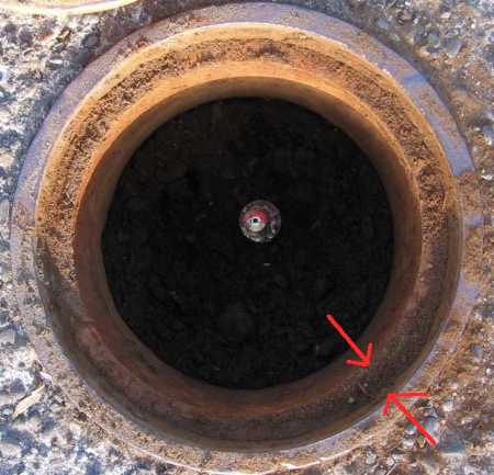
This is not the standard NGS 4 inch logo cap . It is an 8 inch iron cap. I can't see any stamping on the outer rim in your photo. My guess is you will find any stamping on the inner rim, which is better protected from damage. You could also check that lid carefully.
-
Look at this sketch:
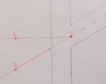
Which one is the extended centerline, AC or BC ? Does it depend on the angle?
Thanks,
Dave
-
First off let me backtrack a little bit. My primary reason for posing these questions was to learn to provide accurate recoveries to the NGS. I am working under the following primary assumptions. IF THESE ASSUMPTIONS ARE IN ERROR PLEASE LET ME KNOW. I will stick to entering DON'T KNOW when the satellite question comes up on the recovery form.
FIRST ASSUMPTION: The NGS would like to receive, from Amateurs like myself, information on whether a site is suitable for satellite observations.
SECOND ASSUMPTION: This applies to most PIDs in the database, not just the high accuracy HARN types,etc., although particular attention should be given to the better sites. I would automatically exclude intersection stationsand the like.
THIRD ASSUMPTION: When the screen on the recovery submission asks if a site is suitable for satellite observations, it refers ONLY to the reception of the satellite signal, and NOT to ANY OTHER FACTOR such as difficulty of mounting a tripod, security of the site, etc., for which I am totally unqualified to express an opinion.
FOURTH ASSUMPTION: The NGS or a local surveyor could query the Database to see if the _SATELLITE: flag was set to quickly pull up a list of only those sites with good sat reception, then look at the individual Datasheets of the sites to determine if that site meets their needs.
Rob and Mike, I apppreciate your responses in helping me to understand this. I thought I had it all figured out with your help... but...Before I had even gotten your replies, I wanted to see what I could find out on my own. I wanted to see if there were any pre-GPS benchmarks that the NGS had put to use as a GPS site. The Database showed me one nearby BL1869 A 1281.
I rode my bike over there today to take a look, and found this.
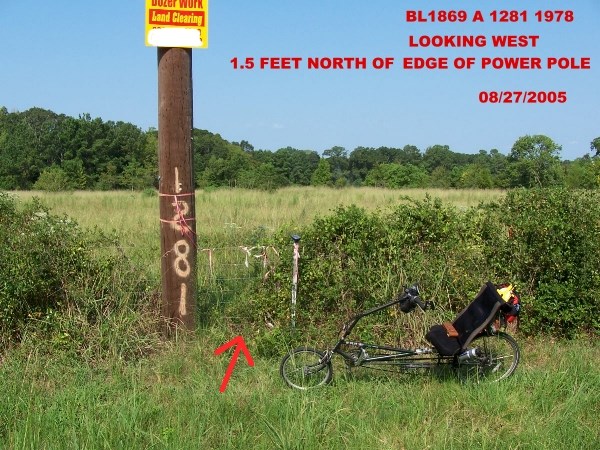
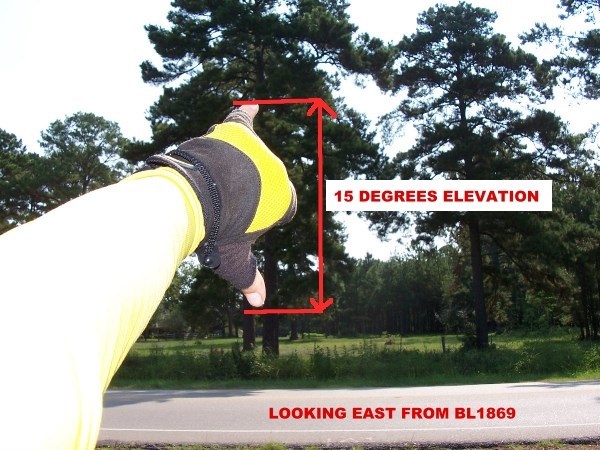
Here is a benchmark, only 18 inches from the edge of a wooden power pole. Across the street, there is a line of tall trees up and down the road. The nearest tree goes up to about 25 - 30 degrees in elevation. I would estimate that, east of the station, the sky is partially obscured to an elevation of 15 degrees or more for 45 degrees in azimuth! (As a side note, people driving by while I was taking the picture of my outstretched hand thought I was nuts.) Yet, the NGS used this site in 2001 for Height Modernization, and DEWBERRY DAVIS said one year ago the site was suitable for satellite observation.
What is an amatuer to think?
Dave
-
Whichever program you use, the 3D info will probably not be very useful for objects close together, as in a typical Tri Station. Most DEM elevation data is on a 30 meter or a 10 meter grid. At short ranges, everything will look flat. It may work for the Azimuth mark, which is typically .25 to .5 miles from the main mark.
Another program to look into would be OziExplorer3D .They have a shareware/demo version you can try.
Dave
-
BTW, the Lowrance site says the sample maps are for the emulators, but they work just fine in your GPS. If you want, you can put the .lcm file in the root directory of your SD card, not a subdirectory.
-
Have you tried loading one of the Lowrance Demo Maps onto the SD card? I would try it using both the Lowrance card reader and you built in card reader to see if it makes any difference. If one of their LCM maps won't work, then something is wrong with your GPS or both of your card readers, or the SD card itself.
What version of Mapcreate did they send you originally? I thought Mapcreate 6.2 would work with most any card reader, not just the Lowrance Reader. If you did get Mapcreate 6.2, did you try it with your built in card reader?
-
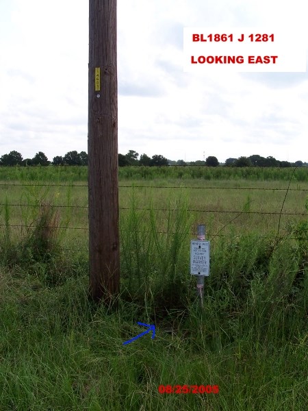
I guess I will have to drive over and check out BL1869 A 1281 , another mark in this same series. If you look at the description, this mark was set only 2 feet from a power pole in 1978, but it is possible the pole has been moved since then.
BL1869  ___________________________________________________________________
BL1869* NAD 83(1993)-  30 11 49.36422(N)    095 45 10.68941(W)     ADJUSTED
BL1869* NAVD 88     -        70.64   (meters)     231.8    (feet)  GPS OBS
BL1869  ___________________________________________________________________
BL1869  X           -    -553,056.064 (meters)                     COMP
BL1869  Y           -  -5,489,550.695 (meters)                     COMP
BL1869  Z           -   3,189,293.472 (meters)                     COMP
BL1869  LAPLACE CORR-          -0.26  (seconds)                    DEFLEC99
BL1869  ELLIP HEIGHT-          43.12  (meters)          (12/03/01) GPS OBS
BL1869  GEOID HEIGHT-         -27.51  (meters)                     GEOID03
BL1869
BL1869  HORZ ORDER  -  FIRST
BL1869  VERT ORDER  -  FIRST     CLASS II (See Below)
BL1869  ELLP ORDER  -  FOURTH    CLASS II
BL1869
BL1869.The horizontal coordinates were established by GPS observations
BL1869.and adjusted by the National Geodetic Survey in December 2001.
BL1869
BL1869.The orthometric height was determined by GPS observations and a
BL1869.high-resolution geoid model using precise GPS observation and
BL1869.processing techniques.
BL1869_SATELLITE: THE SITE LOCATION WAS REPORTED AS SUITABLE FOR
BL1869+SATELLITE: SATELLITE OBSERVATIONS - August 05, 2004
-
Someone please fill inthe blank for me:
A site that is otherwise suitable for satellite observations when submitting a recovery to NGS is unsuitable if a wooden power pole is within _____ feet of the mark.
-
Osprey,
Because MY0279 (GREAT BOARS HEAD 138 RM 1) is a REFERENCE MARK for TRIANGULATION STATION MY0278 (GREAT BOARS HEAD 138), you can calculate the exact coords for MY0279 using the BOX SCORE from the NGS Datasheet :
MY0278* NAD 83(1996)-  42 55 04.48467(N)    070 47 42.16337(W)     ADJUSTED

MY0278|---------------------------------------------------------------------|
MY0278| PID    Reference Object                     Distance      Geod. Az  |
MY0278|                                                           dddmmss.s |
MY0278| MY5185 HAMPTON BEACH ST PAT CATH CH        APPROX. 1.3 KM 2595444.1 |
MY0278| MY5165 TPA 1943                             86.658 METERS 27835     |
MY0278| MY0279 GREAT BOARS HEAD 138 RM 1            53.605 METERS 27911     |
MY0278| MY5168 GREAT BOARS HEAD STANDPIPE          154.222 METERS 29703     |
MY0278| MY5171 HAMPTON MUNICIPAL STANDPIPE         APPROX. 3.9 KM 3160029.9 |
MY0278| MY0280 GREAT BOARS HEAD 138 RM 2            53.825 METERS 32201     |
MY0278|---------------------------------------------------------------------|
Using a program like Geocalc ,you can project a point from MY0278 to MY0279
53.605 meters at an angle of 279 deg 11 min
from coords N42 55 04.48475 W70 47 42.16337.
The calculations say MY0279 is at N 42 55 04.74, W 70 47 44.52 ( N 42 55.079, W 70 47.742)
You can do the same thing for MY0280 ( GREAT BOARS HEAD 138 RM 2). Its exact coords are
N 42 55 05.88, W 70 47 43.62 (N 42 55.098, W 70 47.727)
-
If you want to get the paper data from the USGS, check out this thread and this thread.
-
I did notice that the GPS coords given place the marker about 100 feet north of the one I found. It is possible (though unlikely) that the over pass has been moved to allow for the shopping center that is now there...
For horizontally scaled marks, the coords are only given to the nearest second +/- 6
NAD 83(1986)- 39 02 11. (N) 094 25 19. (W) SCALED
KE0135.The horizontal coordinates were scaled from a topographic map and have
KE0135.an estimated accuracy of +/- 6 seconds.
Using Topozone or the equivalent gives you a much better chance at finding the true coords. The coords they published are about 200 feet from the X on the map in this case.
-
Leigh,
Very often, these older marks can be found on the USGS Topo. The mark in question, KE0135 ,is probably the one marked on the USGS Topo at Elevation 946, which is in line with the published elevation. Here is an enhanced look at the spot.
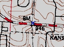
I made the X blue so it is easier to see. The cooords are N 39 02.160, W 94 25.346.
You can get the image by clicking on the Topozone link on the Geocaching page for the mark. Once you get to Topozone, set the Coordinate Format to UTM, then click your mouse right in the center of the Black X by the BM. This will give you coords that are usually within 10 - 15 feet of the mark. USAPHOTOMAPS also works well for this. In my area, I can use this to get coords for marks placed before 1965 or so.
As you can see, this mark is directly under the Highway. 12 1/2 feet puts you awfully close to the tracks. Be careful about Trespassing on RR Right of Way!
-
I believe this is a question only the NGS can answer, but if any of our regulars know, chime in. I know you can get a Datasheet for a mark that is reported destroyed, COND=X. But what about a Vertical Mark that is presumed destroyed, nonpub code COND = Z? What can I find out about one of these? I am guessing that COND=Z will block Datasheet retrieval, while COND=X will not. I looked thru the entire list of NONPUB marks for the state of Texas which you can download in a single file under Misc. Files in the Yearly Archives, and not one that I could find was listed as COND=Z. I am guessing that COND=Z will cause the database to return COND=D instead, even if this is not true.
The reason I am asking is I believe I located a presumed destroyed mark, but can't be sure without the descriptive text. I don't think I can get the descriptive text because the mark is presumed destroyed, kinda of Catch-22 (or a Catch COND = Z).
-
To answer my own question (in part), I think it must be true that there was Geodetic Control done on HAYMARKET AZ MK, because it is listed in the above chart as Horizontal Order 3. So my question is, why is it listed as "No geodetic control at this mark "? Is the Geodetic Control still in a paper file somewhere, just never entered into the computer database?
-
The NGS Datasheet Retrieval mechanism works in mysterious ways. Lets use the aforementioned HV8815 WEST HAYMARKET AZ MK as an example. If you try to download the Datasheet directly using the following link:
http://www.ngs.noaa.gov/cgi-bin/ds_mark.prl?PidBox=HV8815
you get this result:
 -----------------------------------------------------------------------------
 Pid    Name                           Lat        Lon         Elev     O o Hv
 ------ ------------------------------ ---------- ----------- -------- - - --
>HV8815 WEST HAYMARKET AZ MK           38 48 49.4/077 37 52.9          3   D
So, it looks publishable if you can get some Descriptive Text.
But now try this. Go to the NGS DATASHEET RETRIEVAL PAGE .
Click on Station Name. (This works for the other retrieval methods too.)
By Station Name type in "WEST HAYMARKET", Choose Virginia as the state, and check the little box at the bottom that says Browse Mode before you submit. It will return this page to you:
|Dist|PID...|H V|Vert_Source|Approx.|Approx..|Stab|Designation

|----|------|- -|-----------|-------|--------|----|-----------

|....|HV8814|2 .|29/GPS OBS.|N384901|W0773818|C...|WEST HAYMARKET

|....|HV8815|3 .|29/VERT ANG|N384849|W0773753|....|WEST HAYMARKET AZ MK
Click on WEST HAYMARKET AZ MK and then click GET DATASHEETS. It will return this:
 -----------------------------------------------------------------------------
 Pid    Name                           Lat        Lon         Elev     O o Hv
 ------ ------------------------------ ---------- ----------- -------- - - --
>HV8815 WEST HAYMARKET AZ MK           38 48 49.4/077 37 52.9          3   D
>HV8815 WEST HAYMARKET AZ MK           38 48 49.4/077 37 52.9          3   NN
The letter "N" means "No geodetic control at this mark ". This is true for both Horizontal and Vertical.
What is the precise meaning of "No geodetic control at this mark "? Doesn't this mean that no precise measurements by NGS standards are on record? Therefore, even with Descriptive Text, it is still unpublishable. Or does it mean something else?
-
Not only is the disk Canadian, it is in Canada, according to the Geocacher that found it, and not in Detroit, as it says on the Datasheet. Does the NGS normally list stations in Canada, other than those exactly on the US - Canada border?
County Error Followup
in Benchmarking
Posted · Edited by TerraVador
You may want to browse Geodesy for the Layman
Bill, the surface of a lake or ocean is not flat (or spherical). Even in the absence of waves or air pressure, it has peaks and valleys due to gravity anomalies. Refer to the picture below. The curve labeled GEOID represents the surface of the ocean.
Imagine you want to determine the elevation of the point at the intersection of the dashed line labeled NORMAL TO ELLIPSOID and the solid line labeled NORMAL TO GEOID. Call this point X. Lets call the base of the letter P in the word ELLIPSOID above the MASS DEFICIENCY point P, and assume it is 100 meters. Lets call the base of the letter O in the word GEOID above the MASS SURPLUS point O. Its elevation is 0(zero) since it is at sea level.
What is the measured elevation of point X? From point P, can't you see that X appears to be well above sea level? From point O, X appears to be below sea level. From point X, O appears to be below sea level. A closed loop would not yield a zero net elevation change.
I am not a geodesist, but I believe you are right. I don't know how much error is introduced per mile in a typical survey due to gravity anomalies.