


Mike & Jess
-
Posts
519 -
Joined
-
Last visited
Posts posted by Mike & Jess
-
-
The activated carbon filter will also help a lot with taste. I'd probably lean towards the one with the carbon filter.
What can make or break these in the field is how you use them and what you use as a water source.
A puddle or standing water is the last source you want to use with any filtering gear you can carry.
Deeper water (more than a foot deep) a few feet or greater from a shore line would be preferred, but more difficult to obtain.
On a river, most cases, moving water is better than non-moving water.
For water bottle filters (in a foot or more deep water), I'll put the bottle into the water mouth first (so I don't get too much surface water). Once the bottle is in the water, slowly turn it upwards until it's full. This keeps the floating junk up on top of the water, and the bottom dirt, mud, etc on the bottom.
The above does not compensate for industrial contaminants.
If I'm using a filter, I'm in the middle of nowhere, and industry contaminants are the least of my concern. If I'm only doing a day trip, I'll generally carry water from home (which is heavily filtered).
Take what I have here as you will. I can say I've yet to become sick from drinking water on any of my trips.
-
You have no idea.......
Of the 25 caches I own, both under Battleship Command and my own username....I have 65+ favorite points.
Yeah...my caches are thoughtless, cookie cutter, boring, that I whipped together and nobody enjoys them.

Sounds like I hit a sore spot.

I was just saying, for myself and others that are not about the numbers, these C&P GC pages leave the same feeling as power trails.
If you are going to put the effort into mapping out an image, placing all the caches, and maintain them, why not go the extra step?
On a side note, favorite points are used heavily in some areas, and treated like the newer challenges in others. I've seen amazing caches get a half a dozen favorites, and garbage P&G (Pringles chip container) caches get tons else where. If your in a high favorite usage area, an average of 2.6 favorites across 25 caches isn't something to get excited about.
Anyway, I'm not trying to pick on you. Just suggesting that you should go the extra step and raise the bar that much higher on your battle ship series. If it takes you an extra day to get them all listed, you're finders will be glad you did.
-
Although Pretty extreme examples, this does show exactly what I was asking in the OP.
Sometimes you have to be that way in these forums. If not people try to nitpick the smallest things or end up running the topic off course. I've been guilty of being not specific enough and unintentionally running a topic off course.
Back on topic. I mean who really cares about a .5 or 1 star change in terrain? Maybe those trying to complete a fizzy square challenge but that is all. Who really cares about a large change in the terrain rating of a new cache? The CO changed their mind about the ratting and is now correct it. Good for them (and us)! But once a cache has been established (has had more than just a few visitors) if anything that happens that would justify a major and permanent change in the rating then the CO should be also consider archiving and relisting the cache. Something that major of a change I would also image would justify a change in the cache description of the cache and possibly the hint too.
haha, for your example...
Original hint: Up, way Up
New hint: watch your ankles.
The cache I had in the back of my mind during the OP (and no, I don't what that CO to change a thing), would not be an extreme change (half to maybe a star tops). Again, this wasn't specifically about this cache. Depending on the means of travel, and the ratings on most geocaching cultures, it is still a 5 terrain. Just a milder 5 (should have been a 5.5 rating previously if existed).
-
Just a quick friendly reminder, it's hunting season.

When out hunting for caches (non-lamp post caches), be sure to wear your bright orange clothing.
I also strongly encourage to carry a bear bell on yourself and your 4 legged caching partner if you have one.
This is what the one I carry looks like. It has a magnet in the mesh bag which does silent the bell when not needed.
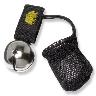
They are annoying, but remember, deer and other wild game don't wear a bell. Pretty hard to be mistaken for wild game if you're wearing one.
-
I finanace and contribute heavily to a local geocaching group forum Northern Ontario Geocachers, and have a Geocaching vendor's site Up North Tracks.
-
A template should only be used as a starting point. It shouldn't be the final product for all your caching pages.
Isn't that what a template means??
For a series of 100 caches.... I AM NOT creating 100 separate pages.
I have a Battleship series of 100 traditional caches and 5 puzzles. I used a template and copied that for all of the traditional ones Nothing wrong with that. It's called being efficient!!
I should have said the template should be the shell of your GC cache page, not the entire contents.
As for being efficient.... You're one of those "
 " type log guys aren't you.
Cookie cutter GC pages, toss and log caches aren't my thing. For the example I gave, we spent the extra effort to make each look slightly unique so it didn't contain the perception of being a thoughtless hide. Not saying your is, but when I see caches (or logs) that are cookie cutter or just a smilie face, I get the impresson no effort or thought was put into it.
That is just my $0.02.
-
This is why, if possible, there should be a feature where the D/T rating is encoded into the log entry at the time it is entered.
+1. That would be great. Save the poor guy who just finished his matrix, while enabling the CO to accuriatly rate his cache.
As great as that would be (and I'm all for it), I suspect there would be a HUGE system (database and page coding) change to accomplish this. Would be great for the game, but very expensive and a lot of risk on the system side
There's no reason to archive a cache if Mother Nature decides to throw a curveball at the approach and make it more or less difficult.
I say deal with it.
Say a cache had a terrain rating of 5 because it was up a tree and climbing gear was needed. Then Mother Nature caused the tree to fall. Now the cache is 6 inches off the ground instead of 30 feet off the ground. If you decided to leave the cache as is. Would you adjust the terrain the rating or is the change significant enough to warrant it to be archived and relisted?
Say a cache was 10 miles down a trail with a significant change in elevation. Now loggers come and build a road thru the forest that comes within' feet of the cache. Would you just adjust the terrain rating or relist the cache?
Although Pretty extreme examples, this does show exactly what I was asking in the OP.
-
Wish I could have the time to commit to blogging on another site. I'm lucky enough to get time out a couple times a year for backpacking and caching.
I do however maintain (as best as I can) write ups and trip reports in the 'Outdoor Living' section of our Northern Ontario Geocachers forum.
How are you planning to organize the site?
By regions? Countries?
-
Do you ever worry about how much it costs to call an ambulance? Or would you rather drive someone there instead?
From my perspective, the difference between that and this is in the ambulance situation you know there's an injury. In the Search and Rescue situation, if you don't make it back by a certain time and it's been 5 or 6 hours passing, no one knows if it's severe injury versus a flat tire or what, so that's why I mentioned I'd feel uneasy about getting charged.
If there was a situation (flat tire or worse), most fees or fines are waved (if exist).
If they show up and everyone is sitting around a fire drinking beer... Not 100% sure it'll be waved if there is a fine.
Outside major tourist traps (grand canion for example), I don't suspect there would be a fine or fee for rescue.
As stated before, most cases a fee or fine wouldn't go to you as you didn't call them. Ambulance shows up at your door even though you didn't call them... Doubt you're paying for it.
-
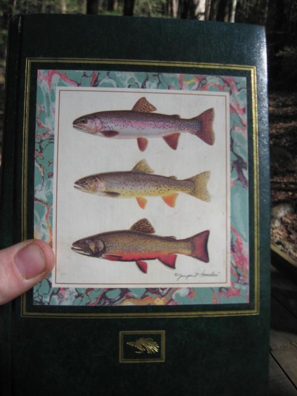
You can bet your sweet bippy I am going to be retrieving and saving this logbook. My dear departed cousin, who was a journalism major, and knowing how I like trout fishing, gave it to me to use as a journal, but the closest thing in my life to a journal is my geocaching history. I miss her a lot and hope this doesn't ever go missing before I get it back. People love the book, and it seems they take the time, mosquitoes be darned, to sit and write something nice in it.
I wouldn't put out something of that much importants to me.
Nice looking book btw.
-
Make one template and copy & paste it to the others.
I did 105 cache series last year doing it that way.
The hardest part is getting the template to be exactly how you want it.
A template should only be used as a starting point. It shouldn't be the final product for all your caching pages.
When I did a FTF challenge, all the caches had a basic template that outlined what the FTF challenge was all about. Each cache page did have it's own description and hints, just the look and feel was similar.
-
I guess my main concern is that I don't mind paying money if I'm injured or lost, but doesn't sound fun to pay if I'm not. Since the probability of getting back too late is more likely to be from a flat tire, etc, rather than injury/being lost, that's why I brought up this topic.
After looking through this forum topic, I guess maybe it would be best for me to call the Sheriff's Department of wherever I hike first and ask if and what SAR charges, since the Sheriff's usually over that. Then I can decide whether to leave a travel plan with someone? I've heard most SAR in the U.S. don't charge unless you're abusing the system, but it may be good beforehand to find out which SARs do charge, so that way I know when it's wise to not leave the travel plan? I don't know, are there any suggestions for adjustments to this plan?
Don't concern yourself about any SAR rescue charge and leave a trip plan.
If it ever came down to it, 9 times out of 10 I would assume there was a charge, it would or could be waved as you where not the one that made the call.
If you hit the panic button on your personal beacon and did not actually need help or rescue, that might be different.
-
Here is the cache the TO is refering to
http://www.geocaching.com/seek/cache_details.aspx?guid=c7176bb8-c5ed-4353-ab0b-81cba119e5f5
Even tho some cutting has been going on....This is still the highest point in Ontario....Check the logs and you will see that the next cacher would probably say it is still a 5/5....Many miles to any road.....no town for miles around, and still a long hike to the top.....I agree with archiving and re-publishing a cache if it has changed significantly but this 1 hasnt changed enough to warant a change in D/T....
This coming from someone who has never been to the cache.
It was a 5/5 in 2010. Now with a bridge crossing the river, no bushwhacking, if you can hike a distance (no special gear required), it is not a 5 terrain anymore. The top of Ontario is a tourist trap now. Driving the family minivan ~80km on smoother then in town logging roads, biking a gravel road (or driving if you cross the river/bridge) for 10km, and hiking 4km +4km (~4km to summit trail head and just under 4km to tower) is not tough terrain.
I do however think it should stay as is to keep the those non-bush savy safe. I don't want to see a cacher from the city assume that a 4 or 4.5 terrain rating in Southern Ontario is the same as a 4-4.5 in the North. There is no cellular coverage, so this could pose an issue for the newer P&G geocaching population.
That being said, this thread wasn't about a specific cache. It was more to grab other's opinions as our large play ground is changing. The cache I revisited this past weekend (because I loved the area) just happen to be the fuel behind my OP as it has changed so much. It went from a very tough trek (6.5-7hours bike/hike/bushwhack from the van) to a weekend outting I'll be bringing the family on next summer (now 3.5 hours). If my (will be 4yrs old next year, with autism) son can hike the trip (which he currently can), it is not a Northern Ontario 5 terrain.
A terrain rating is just that. A rating. It should be applied equally, everywhere. The idea that a 4 in the south should be any different than a 4 in the north does not make sense. I understand your concern, but it sounds to me that people in the south might be over rating their caches. My personal physical capabilities say that if it is a cross country hike with mountains involved, I can handle a 4. I need to be careful with a 4.5 and a 5 is totally out. If people consistently rated their caches based on the actual criteria and not on their own capabilities or the local culture, I should be able to look at a cache anywhere in the world and know what type of adventure I am getting into. That would be a perfect world however. In reality, I can easily find examples close to me where three caches are placed within a half mile of each other on a local trail, one will be a 2, another a 3 and another a 3.5, when using the criteria on the website, all are a 2.5.
I feel the exact same way about the rating system. I have however seen tons of logs (local caches) from southern (Ontario) cachers indicating that what we consider say a 3 terrain, should be a 4, or that our local (culture) terrain ratings are under rated (lower number then they expected for the location).
I should also clarify that Southern Ontario is a high population, mostly cities and organized (trails and maps) parks. Most caches are park & grabs with a couple light hiking caches in local parks.
Northern Ontario is smaller cities/towns, scattered with lots of forest (a very big play ground for some of us geocachers). I placed our first local lamp skirt cache a couple years ago in a city of ~100k POP. Until recently (last 2 years), caching was more of an outdoors sport in the bush (hiking, biking, quads, etc). Park & grabs only recently taken over locally but are still fairly outnumbered outside the city.
-
Doug (7rxc),
You pretty much covered my concerns as well with using the cheap emergency blankets or similar. (My apologies for the incorrect terminology btw, it's been referred to way too many times as a space blanket around these parts.)
I know the material in my winter (snowboard) jacket uses the same principles as an emergency blanket, but was a woven material. I got the coat in the mid to late 90's and as far as I can tell, the inner reflective lining has withstood the abuse (stuff sacs, etc) I have put the coat through. If I can find a similar material (that doesn't require 1000yrds min purchase), this would be exactly what I'm looking for as a DIY project.
As for the material breathing, he weaves should allow air through, and the zipper of the bag and top opening would not be covered, so that probably would take care of moisture.
Alternatively, I could use ripcord to secure a emergency blanket under and on top my sleeping bag. Would look kind of ghetto, but would work and that is all that matters.
As for fill... I am not sure if I would add any if I was to build my own bag. My current sleeping bag does not have any (from what I can see without removing some stitching). If I can keep most of the body heat in with a reflective fabric, I could always (as I have with the two previous trips) compensate for the lack of fill with wearing my base camp cloths to sleep (comfy cloths I carry to wear base camp if I happen to get totally soaked or muddy while traveling).
I'll keep looking for solutions. My backpack/hiking sleeping bag is now on the shelf until next spring. The heavier gear is now coming out for winter.
-
I make a plan and let people know where I'm going. I leave that plan with a reasonable person who knows me. I give the time estimate of if everything goes perfect and then my reasonable person is able to watch the weather. Depending on what is going on (snow storm, wind storm, thunderstorm) they are able to mentally adjust my anticipated return time. If I find I have a bar of cell phone covereage and i know something is going awry I call or text that there's been a change. I also put an absolute end time in my information that point by which absolutely if I'm not back then it's time to worry.
Also I monitor the weather myself. I don't go out when severe weather is anticipated. We don't get a lot surprise severe weather where I am. Also I monitor when I'm hiking around. If it looks like rain I don't go somewhere that I might not be able to extricate myself from due to rain. Rather make a healthy choice than get stuck.
There's just too much wilderness where I am to not let people know where I'm going and when I anticipate being back. I'm not willing to risk it. I've also never had SAR called for me even when I've been late since people had my plan. I've also been the plan holder for people and never had an inkling to call SAR because they weren't back at the minute they said they would be. Most people are reasonable.
You must either not be married, or do not give your wife the responsibility for making the SAR call.
I have to give my wife buffer time (do not call a rescue before this time). That being said, no matter how much experience I have under the belt, my wife will always worry.
-
Chalk me up to the accurate ratings crowd. Cache listings have to be accurate, otherwise you're lying to your "customers". I certainly don't care about your fizzy grid, nor do I really care about mine. I'm bringing you to a location for the location, not to fill a square. If you want to use my cache to fill a square, that's completely on you. My goal is to represent my caches in an accurate manner.
And I take issue with whoever said that people wouldn't go look for difficult/rare combos without the presence of the fizzy challenges. I do. Those are the caches that I enjoy the most.
There's no reason to archive a cache if Mother Nature decides to throw a curveball at the approach and make it more or less difficult.
I say deal with it.
I can't agree more.
-
I have them bronzed and mounted and display them proudly on my fireplace mantle.
You either have a HUGE caching budget and big fireplace mantle, or have not recovered many logs.
single sheet...toss
log book...keep
I'm pretty much the same. I'll read through them then toss the single sheets.
If a log book is hardly used, I may pull the consumed pages and re-use the book.
I have as of right now (going up again in the next couple days) 62 hides (active, and archived with a couple events in there). My geocaching budget isn't high anymore, so re-use what I can is a must.
-
I retrieved mine not too long ago and compared the signatures against the online logs, there were way more names than online logs, nice to see that not every cacher feels the need to online log a find, kudos to them, it really IS not about the numbers.
I've done this a couple times and noticed way more online then in the books or log sheets.
True, it's not about the numbers, but I don't log online for the bragging rights. I do because there's more space there to tell any stories I might have about finding the cache than there ever will be in some log books.I retrieved mine not too long ago and compared the signatures against the online logs, there were way more names than online logs, nice to see that not every cacher feels the need to online log a find, kudos to them, it really IS not about the numbers.
I do the same for the caches I find. Drives me nuts when cachers put "TFTC" only or worse yet "
" in the online posts, so I try to put a little bit of a personal touch to the online log.In the paper log book, name, date/time and something very breif so I don't consume too much log space.
Don't have any of my own yet, but the ones I look after for others, I periodically use my digital camera to photo the strips/log pages and then merge them into one or more condensed but readable images. Easier to store them for me, also to send them along to the owners in question. I occasionally do this for people I know when I find one of their caches wet and the log deteriorating but still readable. First I dry it out AMAP then image the logs. Haven't had to do that too often but a few times. Sometimes the log simply isn't recoverable at all, even with good technique. Sometimes you only get bits. Needless to say it isn't often worth the effort for many caches of low import, so it is a judgement call.
Any that survive to the point of replacing, I keep until told to lose them by the owner in either case.
Doug 7rxc
I've done this one for a wet log book I recovered. Sent the photos to the CO.
I also do this occationally if I happen to pass one of my caches. Nice to read the hand written notes when time permits.
-
I thought I would toss this up as I'm interested in what others do with their old cache paper logs (books and strips) when they either get full or you archive the cache.
-
Leaving a fresh log is always a nice thing to do.
If the cache has room, leave the old one in there.
The problems arise when there is only room for the log, and only one log.

You might just do nothing, and simply state the situation in your log. If there are several previous comments about the full log, you should consider posting a 'Needs Maintenance' log, as well as your 'Found It' log.
If you decide to remove the full log and replace it, send a message to the owner and offer to get the log to them if they want it.
This pretty much covers what I would say.
I've added plenty of new log books to caches and or repaired caches (generally early spring when they come out from under the frozen snow). Depending on how I am caching (via mtn bike or with my young boys) I tend to carry one regular cache (complete), a number of ziplock bags and a pack of dollar store note books. I'll also carry a bunch of nano and micro log strips.
If a nano or micro is full and I know the cacher is a local, I'll replace it and contact the owner so they can meet up to obtain the log if they want it.
If I repair a cache (with NM attribute or not), I'll inform the CO so they are in the know, and can remove the NM attribute if exists.
In all honesty, not this year, but the previous, I replaced/repaired too many caches. I had actually impacted my own supplies to the point where I had to start letting caches go.
Now, if the cache is worthy, I'll still repair/replace the log book. If its a toss in place cache, I'll let it go.
Sorry, went a bit off topic.
-
It's a matter of debate, more than anything else.
What is true however, is that some (not all, by any means) phone geocachers are so enamored by finding the new "sport", they rush to get a hide out there. Three pitfalls to this, 1) they may well have not read any guidelines; 2) they don't really know how to obtain "good" coordinates; 3) as a part of 1) and 2) -- they rush to git 'er done. See the problem?
Add to that, they stay with it for a week/month/year and then move on to other things. Their "junk" hide still exists.
Those who know and understand how their device works (not just "phones", either) usually make for more accurate placements.
BTW, a fourth problem also creeps into the equation -- "cache migration". When a finder 'hides it better than they found it"; the next finder also 'hides it better than they found it" (they haven't a clue where it originally was), and so on and so on.... I think you get the picture.
I am not a smart phone user (nor will I say what I think of them -- the phones, not the users), but I do not see phones as being the problem. It's the users.
Its all depend on the day, weather, and even where the satellites are in the sky. The worse places I see are around buildings and on the north side of a mountain. (south side of a mountain is where the satellites are in the sky)
I see smart phone way off and some right on. Same with those fancy GPS as well.
The key is, take a reading for like 15 mins and it will avg out, but its still not perfect.
I think the two quoted posts above cover my thoughts.
Inaccurate hides doesn't mean it was a smart phone. I've had days where my Oregon 300 was dead on with my other GPS units, and other times, it was all over the place.
A critical item I watch for is the GPS's estimated accuracy. Of my Garmin indicates above 3-4M accuracy, it's going to take some time to place the hide. If I have a 3-4M estimate accuracy, I'll do a couple tests (approach from different directions and/or with a different unit). Some area or days, accurate cords can be tough to acquire. I've had to return a couple times to place a hide because I just couldn't nail down anything remotely accurate. For a couple of my caches, I've had to give better hints as the location just wouldn't give up a satisfactory accuracy. The two caches that come to mind where both along fault lines in a rock face and/or with heavy tree coverage.
-
I think all the previous posts covered my thoughts about what the attribute should be used for.
My only suggestion would be to make some sort of clear indication of what needs to be done.
I've seen a few mystery cache where the CO put a lot of time, effort and thought into it, but did not give a clear hint or indication as to what was needed to be done on the cache page, image or external link.
Some people might get the CO's idea right away, and others will lose interest and move on to another cache.
-
So myself and 2 others cachers were discussing this as a possible suggestion to GS.
As a team, we recently created a series of caches that number 63 total. Rather than create 63 individual cache pages it would be GREAT if one could create 1 single cache page and have the option/ability to create a copy the page 62 more times. Maybe have a box to select "Copy current cache page" and then enter the number of copies of that page in another box?
This would greatly help with powertrails and caches series...
Granted...you'd still have to change up the coords, but that is minor tweeking compared to all the things that need to publish a series or powertrail...
Thoughts???
We did something similar about 2 years ago. There was about 5 of us that placed the caches in Sudbury to create the Northern Ontario Geocachers initials (NOG).
Some of the cache page was copy & paste in order to make it known they where part of a set (41 caches). We did however place them as seporately (not the whole group at each cache) so that each cache as a slightly different flavor based on the cacher that hid them.
This allowed the caches to be slightly different and provide finders a veriaty while hunting.
The results looked like this;

GC map:
Why does it seem that so many are in such a rush to degrade the quality of the game?
TFTC and blank logs, cookie cutter caches, power trails, cut and paste cache pages, why?
Is there some nefarious plot to suck every last drop of fun out of the game?
I share the same opinion. The worst for me is the "
" logs. Cacher was too lazy to even type and simply hit a smiley face. Keeping someone inline with the OP topic, I will be disappointed if they totally remove the older hide submission pages and go with the newer one only. When I go out with the boys hiding caches, having to click through a dozen pages would be a pain if I'm logging 2+ hides. The older top down (one page for cache info, one page for attributes) is a lot easier and quicker. If they moved the attributes to the cache info page (in the older format), it would make life easier and possibly find more (senior) cachers using the attributes a bit more.
-
Here is the cache the TO is refering to
http://www.geocaching.com/seek/cache_details.aspx?guid=c7176bb8-c5ed-4353-ab0b-81cba119e5f5
Even tho some cutting has been going on....This is still the highest point in Ontario....Check the logs and you will see that the next cacher would probably say it is still a 5/5....Many miles to any road.....no town for miles around, and still a long hike to the top.....I agree with archiving and re-publishing a cache if it has changed significantly but this 1 hasnt changed enough to warant a change in D/T....
This coming from someone who has never been to the cache.
It was a 5/5 in 2010. Now with a bridge crossing the river, no bushwhacking, if you can hike a distance (no special gear required), it is not a 5 terrain anymore. The top of Ontario is a tourist trap now. Driving the family minivan ~80km on smoother then in town logging roads, biking a gravel road (or driving if you cross the river/bridge) for 10km, and hiking 4km +4km (~4km to summit trail head and just under 4km to tower) is not tough terrain.
I do however think it should stay as is to keep the those non-bush savy safe. I don't want to see a cacher from the city assume that a 4 or 4.5 terrain rating in Southern Ontario is the same as a 4-4.5 in the North. There is no cellular coverage, so this could pose an issue for the newer P&G geocaching population.
That being said, this thread wasn't about a specific cache. It was more to grab other's opinions as our large play ground is changing. The cache I revisited this past weekend (because I loved the area) just happen to be the fuel behind my OP as it has changed so much. It went from a very tough trek (6.5-7hours bike/hike/bushwhack from the van) to a weekend outting I'll be bringing the family on next summer (now 3.5 hours). If my (will be 4yrs old next year, with autism) son can hike the trip (which he currently can), it is not a Northern Ontario 5 terrain.


Anyone had luck with machetes?
in Hiking/backpacking
Posted
I agree with your first bit.
The risks you outlines are really no different then any edged knife, ax or even snips (ok, harder with snips ).
).
As with anything, machetes have their place, and when handled properly, can be used safely (same as an ax, car, or fire arm). Regarding the snips... hard to make kindling with them and they can be heavy and hard to pack while backpacking.
Not going to touch the environmentally unfriendly bit. Our existance is environmentally unfriendly.