


Jim W
-
Posts
281 -
Joined
-
Last visited
Posts posted by Jim W
-
-
Airmapper, what software was you using for tracing the birds? sounds interesting
-
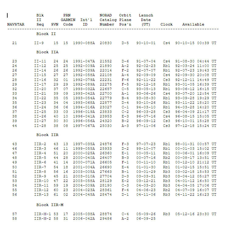
Thanks PDOP's, that's what I needed, now when I go to Real Time Satellite Tracking and I want to see the latest GPS satellite lanched on 9/25/06 I can cross referance it to NAVSTAR 58, and GARMIN 31
Thanks for the link on real time tracking, and also I did notice that both my eXplorist XL and 60Cx had Identical numbering on the satellite screens, and I was able to compare up to 5 satellites at a time on the above link.
The Only problem now is to force the use of the new WAAS satellites on the eXplorist XL.
EDIT: I also made these charts my desktop wallpaper on the Laptop and my Home PC now. thanks.
You're Welcome GOT GPS, glad I could help
-
I used the same names as NAVSTAR for the WAAS satellites
-
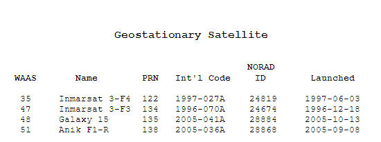
I put together a chart with satellite ID reference numbers to help with finding information. You can find it here http://www.teamtrailwalker.com/id186.htm
Nice chart Team Trail Walker
-
What link did you get the above list with the NAVSTAR numbers on it? I'm not seeing it.
I modified the chart by adding the NAVSTAR numbers in Microsoft Word, if you want a copy of the file PM me your email address and I'll send it out
-
Thanks PDOP's, that's what I needed, now when I go to Real Time Satellite Tracking and I want to see the latest GPS satellite lanched on 9/25/06 I can cross referance it to NAVSTAR 58, and GARMIN 31
-
Thanks PDOP's, that helped some, but still doesn't tell me what numbers Garmin is using
-
There so many SATELLITE numbers, you have GARMIN numbers, PRN numbers, SVN numbers, US SPACE COMMAND numbers, and NAVSTAR numbers, is there a cross reference to all these numbers? Does anyone have a spreadsheet to cross reference them?
-
Just a quick quistion, is #35, #48, and #51 the same as NAVSTAR's number 35, 48, and 51 for real time tracking?
-
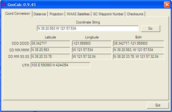
Waypoint projection is a tool for calculating coordinates based on given coords, bearing, and distance. You may see puzzles like this one.
Not sure about checksums.
No, you don't plug in; this program is stand alone. It's basically a calculator using coords and such. Could be very helpful. I don't use it 'cause my 60cs and pda both have this utility built in
 .
.I'm thinking checksum means the program adds up the coords for you. Many puzzles have checksums to help out you confirm you have the correct coords. The owner will post N and W checksums and if the sums of your coords match the owners, chances are you have the right coords. This is kinda outdated as puzzle owners are beginning to switch over to this web-based coord checker.
Thanks Chuy!, I probably won't use Projection or Checksum, but the rest of the program is very useful
-
Is anyone using GeoCalc ? It's Free GeoCalc 0.9.42
But I have a couple of questions, what is the Projection, and Checksums used for ?
UPDATE: I just did a search, and found out fizzymagic (here on the forum) wrote the program, and want to say thanks for a great little program
-
31 Launched 25 SEP 2006
The newest of the GPS (not WAAS) sats. It is second of the new generation gps sats with a stronger signal and civilian duel band signal. Probably flashing because it may still be in test phase.
EraSeek, I'm just curious how did you find out that GPS 2R-15 Launched 25 SEP 2006 has been given SVN 31 ?
-
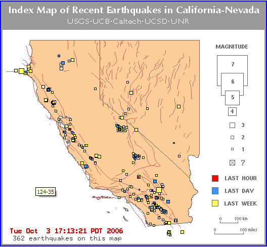
LOL wiseye, we have earthquakes everyday out here
-
Why is it no one wants to use 35 ?
-
Tkanks k statealan, it must be a problem on their site... Great avatar

-
You may want to check this out.. FAKE SanDisk Ultra Compact Flash Cards Exposed
You can also contact SanDisk to see if you have a fake
-
When I go to the Groundspeak cache site and click on Mapquest to show the location of the cache it comes up with a broken frame, is anyone else having this problem ? or do I have a setting in my browser set wrong ?

-
-
Thanks Klatch, for the screen shot, how much of an area (feet, miles) does your map cover ?
If you mean the screen shot, you can see the 500 foot scale on the screen. If you mean each segment, it seems to vary depending on the topography because I try to stay near the 50 mb limit suggested by Bus36 - more rugged terrain = more contour intervals = more data? Just my impression. I tried larger segments and it really takes a long time for some of the apps to process them. I would say my average segment is about 15 miles square (225 sq. mi.), some more, and some less.
Thanks Klatch, that answered my question (225 sq. mi.)
-
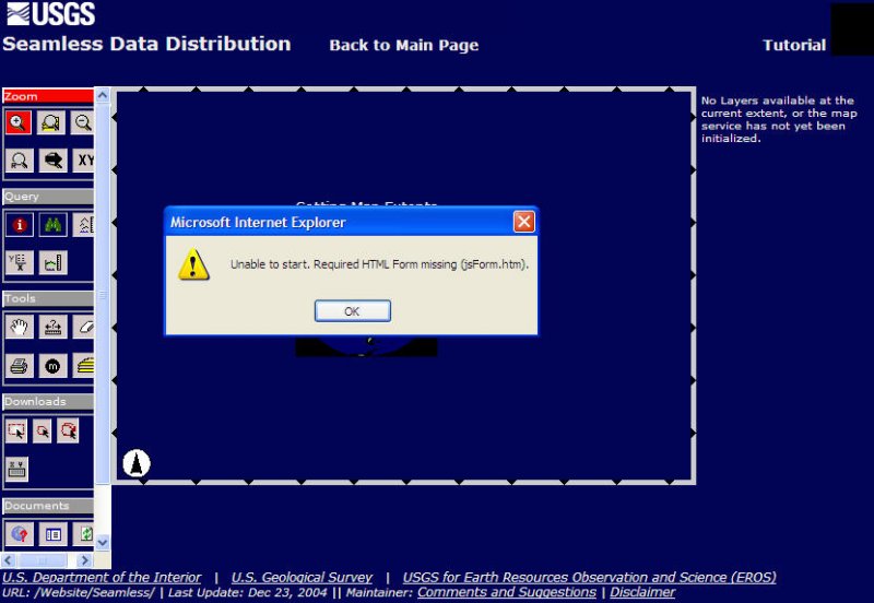
Everytime I go to the USGS site I get this error, can someone tell me what this is, and how to fix it or is there something wrong with the USGS site
I just tried and it's working for me. How long have you been trying? The "js" makes me think it's a Javascript error of some kind. Is your javascript enabled?
Thanks 'Team Perrito Blanco, that's what it was the javascript was disabled
-
Everytime I go to the USGS site I get this error, can someone tell me what this is, and how to fix it or is there something wrong with the USGS site
-
Thanks Klatch, for the screen shot, how much of an area (feet, miles) does your map cover ?
-
Could someone please post a screen shot of one of the topo maps they've made
Thanks
-
Pocket PC only
Sorry, I should have stated that in the heading
 .
.
Satellite Numbering System
in GPS technology and devices
Posted
Thanks Airmapper, I'll give it a try