

jsargent
-
Posts
30 -
Joined
-
Last visited
Everything posted by jsargent
-
Very cool. Where was this at? No top. No doors. Middle of winter. I am sooo jealous. Katemcy Rock, Texas. Yes is was a great weekend!
-
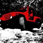
Hereis mine from this past weekend.
-
For the most part I must admit it is annoying but I have had a couple of time that I was enjoying the scenery and not paying attention and it saved me from walking past the cache.
-
I agree with the previous poster. That is probably not the best way to go for a hiking boot. Get a pair of boots designed for hiking. I had a good pair of Raichle boots that lasted about 15 years. Good heavy duty leather uppers which are still good. I just need to get them resoled. My latest pair of boots are a pair Vasque. If I remember they were about $79 at Bass Pro or Cabelas, I don't remember which. While I have only had them about a year, I love them. Very comfortable on the longest hikes. They are great on the rocks and in a couple of places have almost had too much traction. The problem with picking boots is that every one's feet are a little different and what works for me may be horrible for you. Your boots can make for an enjoyable hike or a totally miserable experience. The best recommendation is to go look at boots where the staff is knowledgeable about the activity you plan to use them for, like REI or another outdoor store.
-
The last couple of times out with 2.70 I lost all my geocaches which I had loaded . No problems today with 2.80 loaded. I'll keep my fingers crossed.
-
How to make your own Garmin trail map
jsargent replied to michigansnorkelers's topic in GPS technology and devices
I'm not sure if it will work with the 60 series but it does work with the 62 series. Garmin Custom Maps -
This little guy was near the cache this past weekend.
-
Just put mine on earlier this week. It fits fine. How it works long term is yet to be seen.
-
Are Garmin 62s/st units ready for prime time?
jsargent replied to TexasCacheCrew's topic in GPS technology and devices
I love mine. I moved up from a well used Legend so it was definately a step up and I can't really compare it to the 60Cx. I like the paperless caching and the improved acuracy. It think that most of the issues will be worked out over time so I am not overly concerned. YMMV. -
This sort of thing is happening more and more often. It's disrespectful. Cache finders are starting to get mad as heck and they're not going to take this anymore. If geocaching doesn't implement something, then cachers will feel it necessary to use the logs to get their message across to COs. The forums don't work, probably only 5% of cachers read the forums. The online logs get the message across to the CO and to future finders. People need to grow up. Its a geocache... Geez. You find it or not. Life goes on.
-
Except for the stubbed toe the feet are recovering nicely. I was thinking of going for a run this evening in the five fingers but I think I'll geve it another day or so. I had looked at the Teva Fi but the new model has some poor reviews so I may try the Katavi. For the last 20 years or so I have had good quality, heavy duty hiking boots and quite honestly I feel I am less likely to turn an ankle in these five fingers. I just need to learn to keep picking up the feet to aviod stubbing the toe. I do feel more in tune with my surrounds though and while my boots will still have their place, I will be weraring them less and less.
-
I have questions for the barefoot hikers out there. I picked up a pair of five fingers a little over a month ago and have done some caching/hiking about 6 times now, each time getting a bit more adventurous. I had gotten up to a 5.5 mile hike on a mostly dirt, pine forest trail.Today I took a trail that I was not familiar with which turned out to be mostly gravel road and it was about 6.5 miles. My question is do your feet toughen up to the gravel like this or is it better to switch to more padded sole like a trekking sandal for this type of terrain? I really enjoy the five fingers and am planning on doing more in them as well as moving to go barefoot. If the feet can toughen up to walking on gravel then I can suck up a little discomfort to reach my goals but I'm not afraid to do sandals if they are appropriate for some terrains.
-
Can't retreive waypoints from GPSMap 62s
jsargent replied to roachgps's topic in GPS technology and devices
In mapsource, File => open. The GPS should show up as a drive, look in the folder X:\Garmin\GPX\. You will see one or more files called Waypoints_[Date].gpx. -
Go>OffRoad??? I don't see OffRoad as an option in any of the menus on mine. While in the Geocaching profile I can use the "quit" and "page" buttons to scroll through the menu bar. You can scroll the the "Geocaches" menus and then log the attempt, or if you are on the map page hit the "menu" button and then go to the view geocache option. After I hit the geocache I want, a screen pops up that says GO, a screen pops up that says Set the Guidance Method for this route.......Off Road, On Road for Time, On Road for Distance. I haven't installed City Navigator yet, so this may show up only if you are using the topo maps. What is the Geocaching profile? In the main menu there is a "Profile Change" option. It will allow you to set defaults for different profiles, geocahing, automotive, recreation, marine, etc. Select the profile you want and then set up the GPS as you would want it for that profile. Switch to the next profile and then set that one up for that activity. For instance, I have my automotive profile setup to use the street maps, and the automitive view. The geocaching profile is setup to use the topo maps and the North up view. I can then use the automotive profile and it will guide me via roads using the streetmaps. When I arrive at the trailhead I switch to the geocahing mode and it guides me straightline (off road) with the topo maps displayed. You can change anything on the unit at it will stay with the profile you were in when you made the change and will not transfer to the other profiles. You can add, remove and change the order of pages on the page menu. Use different maps, views, etc.
-
Go>OffRoad??? I don't see OffRoad as an option in any of the menus on mine. While in the Geocaching profile I can use the "quit" and "page" buttons to scroll through the menu bar. You can scroll the the "Geocaches" menus and then log the attempt, or if you are on the map page hit the "menu" button and then go to the view geocache option.
-
GC2B034 Necropolis at Brittania Manor III
jsargent replied to Cybercat's topic in General geocaching topics
It took us two days due to one of the legs being closed sooner (and we got a bit stuck doing one of the earlier legs) than we had anticipated but it was well worth every minute of this cache. We delayed doing the final leg till after dark, and it was a great experience. The pictures you've seen and the stories you've heard do not do it justice. You must do this one! -
It would have never occured to me that "stealth" mode would be required on a 5/5 cache. I haven't done this one yet so I'm not sure how accurate the rating is. Fortunately the muggles became cachers in this case. It is certainly proof that you're not as stealthy as you think you are.
-
As for the maps, you have several options. First you could certainly purchase then from Garmin. I prefer to get the free ones at http://www.gpsfiledepot.com/. There are plenty of tutorials there that will help you get them downloaded and installed. If you need routable maps ou can try http://garmin.na1400.info/routable.php for some free maps.
-
caches on or very near electrical equipment
jsargent replied to Fusilli Jerry's topic in General geocaching topics
strictly speaking i can't agree with this. after a cacher found one of those hides, they will be less concerned and more likely to poke around real electrical boxes in the future (not knowing which is which). Is this the coverse of once burned, twice shy? Sorry -
It's a little more than "just driving". Seriously, we had a fantastic time in Big Bend NP alternating between long day hikes and trail rides. We would do 6 - 12 mile day hikes on day and 20 - 50 mile trail rides the next. There are a couple of virtuals there that without a ORV you will not get to it. Even then I'm sure there is considerably more walking involved than 99.9% of the LPCs out there.
-
<---(pssst...click the little laughing signal) snyder and snowball pegged it just right. Now where you may live...? Mountain Mardi Gras and 4x4 Caching Adventure Depends on where you live and how far you are looking to travel to wheel. Unfortutunately here in Texas the only places to wheel are private parks. Pay to play is not compatable with geocaching.
-
you have to name the bmp file to the same than the replaced waypoint is named. that said: name your smiley bmp to »Geocache Found.bmp« Happy Hunting Hans That worked, thanks. I knew there had to be something simple.
-
Saving them as 24 bit worked for me as well. I'm trying to figure if there is a way to change the default found icon to a smiley face. I've explored everywhere and have been unable to find an option.
-
Casual Friday: Wear your Geocaching Shirt/Gear/Accessories
jsargent replied to Snoogans's topic in General geocaching topics
You can't even add a piece of flair? My uniform is official and even I can wear a geocaching pin. I'm guessing that Snoogans works for the same "company" as I do. No wiggle room. -
I have always loved night caches. Especially here in Texas it is sometimes the only time the temperatures are tolerable. There are certainly more issues with setting one up, parks that close at night, safe areas in respect to terrain and local inhabitants, etc. There is a lack of them around here so I just recently set up a new one(GC2E7V2 ). This is a very simple one to get new commers used to the idea of caching at night. I am working on another one that will be far more involved and a lot more fun. I will be using ideas I gained from this one - http://www.geocaching.com/seek/cache_detai...f1-b587fef7b217. It will be quite involved but I believe worth it in the end. The previous cache was one of my all time favorites.