


stefanwilkens
-
Posts
34 -
Joined
-
Last visited
Everything posted by stefanwilkens
-
Are You Smarter Than a Garmin Engineer?
stefanwilkens replied to Atlas Cached's topic in GPS technology and devices
My point was that my eTrex 20x recognizes S-745 as #91. It's also known that S-745 is a satellite in the GLONASS-M range, which has IDs ranging from 21-92. Why the etrex would potentially be using this numbering rather than the standard I do not know, it's just a possible explanation for GLONASS-M sats showing up with different numbering. Nontheless it's strange. -
Are You Smarter Than a Garmin Engineer?
stefanwilkens replied to Atlas Cached's topic in GPS technology and devices
I did, the positions seem to correlate. The website: My eTrex 20x: The positions of the GLONASS units seems to overlap well: This tells me that #745 is GLONASS #91 according to my eTrex 20x. #91 is a satelite ID in the GLONASS-M range, according to the wikipedia link I shared before. Could it be that they use a different numbering scheme for GLONASS compared to GPS? The positions seem to be accurate though. -
Are You Smarter Than a Garmin Engineer?
stefanwilkens replied to Atlas Cached's topic in GPS technology and devices
In the Netherlands, I just checked for you. My phone shows GLONASS satellites between 08 and 24, meaning 72 up to 88. My eTrex shows GLONASS up to 92. Could it be that these are GLONASS-M units (that range from 21 to 92?) https://en.wikipedia.org/wiki/GLONASS
-
Garmin eTrex 30x Issues? $130?
stefanwilkens replied to SkellyCA's topic in GPS technology and devices
I found that maps stored on the SD card are significantly slower to update while hiking, the map tiles don't update as quickly as they do when the map is on internal memory. The difference was so big that I eventually stopped using the SD card for map storage. As an indication; I would walk a trail and cross a junction. The map tile would update after I passed the junction. With the same map on the internal memory, the tiles update far quicker. I am using a 32 Gb class 10 Samsung card. Other than this though, the device is really good. I love the screen especially, one of the best I have used over the years! Great deal. -
Any recommendations on a GPS?
stefanwilkens replied to TheTiger11's topic in GPS technology and devices
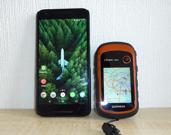
While remaining in the realm of "not too expensive", the Garmin eTrex series is probably your best bet. 20x can be had for around $150 on amazon. Good visibillity in sunlight, SD card expansion slot... Get a screen protector for it though! Make sure to get the 20x or 30x version though, the normal 20 / 30 versions don't have the better screens that the 20x and 30x come with. The use of a GPSr unit depends on where you cache, I have found. If you are mostly doing quick urban / city caches, phones are usually fine. If you do more serious / time consuming caches, a dedicated GPSr with better reception is forested areas will give you better results. -
Hallo! Voor de "gewone" caches die je zeker in het begin zult op gaan zoeken is de Android / iPhone app vaak prima, daarmee kun je kijken of je het op de lange termijn ook leuk blijft vinden. De GPS functie in je telefoon is in stedelijke omgevingen vaak meer dan prima. In overdekte gebieden (bossen etc) kan het nog wel eens tegenvallen, daar heb je meer aan een "echte" GPSr unit. Android app is hier te krijgen: https://play.google.com/store/apps/details?id=com.Groundspeak.geocaching.intro&hl=en iPhone hier: https://itunes.apple.com/us/app/geocaching/id329541503?mt=8 Dit raad ik je aan omdat een redelijke GPS toch al snel flink wat geld gaat kosten, zo kost mijn eTrex 20x (die ik zeker aan kan bevelen!) op het moment nog zo'n 169 euro. Mocht jij ook naar dit type GPS units gaan kijken, let dan wel op dat je de x variant neemt, niet de gewone eTrex 10, 20 of 30 - die hebben een scherm wat zeer slecht te zien is in daglicht. Het scherm van de 20x en 30x is vele malen beter. Mocht je na het lezen van het bovenstaande toch alsnog graag advies hebben voor een GPSr, zoals dat heet, kunnen we je zeker op weg helpen. Persoonlijk raad ik je de eTrex 20x aan, omdat: Het scherm zeer goed zichtbaar is in direct zonlicht Gratis kaarten beschikbaar zijn via http://garmin.openstreetmap.nl/ (absoluut doen, deze kaarten zijn vele malen beter dan de standaard Garmin kaart) Opslag uit te breiden is met een SD kaartje Hij probleemloos 2 dagen lang cachen overleeft op 2 penlites Let wel op dat de besturing via knopjes gebeurt, geen touch screen. Als afsluitertje heb je hier een lijst van Garmin GPS toestellen die ondersteuning hebben voor Geocachen: https://buy.garmin.com/en-US/US/c12521-p1.html?FILTER_FEATURE_PAPERLESSGEOCACHING=true&sorter=featuredProducts-desc En anders is er altijd nog marktplaats
-
De OSM kaarten die je hier weg haalt: http://garmin.openstreetmap.nl/ Bieden 4 download opties, de laatste hiervan kun je na downloaden en uitpakken rechtstreeks op je GPS zetten. Geen basecamp meer nodig Let bij het plaatsen even op dat hij op de juiste locatie staat. In het geval van mijn eTrex 20x staat hij op de SD kaart in de Garmin map.

-
Finally moving from Windows 10 mobile to, what?
stefanwilkens replied to Vidfamne's topic in GPS technology and devices
What kind of price category are you thinking about? The next big step in Phone GPS accuracy is the BCM47755 chip, which allows far greater accuracy than current chips. Sadly, no phones exist with this chip yet. https://spectrum.ieee.org/tech-talk/semiconductors/design/superaccurate-gps-chips-coming-to-smartphones-in-2018 If you want something available now, it doesn't really matter for GPS accuracy. They are all in the same ballpark. -
You could do a study of the on-line interactions as well, people dish out entire personal wars on forums / logs sometimes Either way, feel free to drop me a questionnaire or something!
-
Potentially Lying Geocachers
stefanwilkens replied to EmzyJanezy's topic in General geocaching topics
Anyway, getting back to the point of the topic ... You'll always run into things like this in any free public thing, it never lasts very long though. Eventually they'll get bored and move along. Some people make it a sport to false log just for the numbers, others like to collect trackables... in the end, who cares. You are out there to find a location, log it, maybe enjoy some nature, maybe share some trackables... sure, sometimes you'll find some destroyed caches, unmaintained caches. Hell I once found one filled with dog poop. It's usually the "urban" or close-to-cities caches anyway. Either way, it's best to just enjoy playing the sport / game and ignore things like this. Like you said yourself, these logs are obviously nonsense, easy enough to ignore. A cache owner can decide if he wants to do something about that or not People jack around to get attention, don't give it to them and move on. -
What kind of budget are you thinking about? I can only speak about entry level units. I'm personally enjoying the new Garmin eTrex X range of units. The new screen they use is these units is really nice in sunlight and they have a nice variation in price / features. They all support geocaching to a degree. They all support GPS, GLONASS, WAAS and EGNOS. Be sure to get the X range though, they have new better screen which perform much better in sunlight. A non-x version of the 20 and the 30 also exists, you do not want that. eTrex 10: black and white screen, no maps, $100 eTrex 20x: color screen, maps, SD card slot, $200 - the minimum in my opinion. eTrex 30x: color screen, maps, SD card slot, compass, barometer, wireless connectivity with compatible Garmin devices, chirp support, $300 These are good for semi casual caching and hiking, they (20x and 30x) will support routable maps and detailed maps can be gotten for free from http://garmin.openstreetmap.nl/
-
I like using the GPSr to navigate while using the phone for other things, most phones also don't have support for WAAS / EGNOS and typically have less sensitive GPS reception compared to dedicated handheld units. Based on comparing my Nexus phone to my etrex 20x anyway.
-
A guess: Looks like a mystery where the fake coordinate is being uploaded rather than the solved coordinate?
-

-
A bunch of mature people walking around the school grounds who seemingly have no goal to be there is just not right, school grounds should be avoided completely in my opinion. Why make the teachers, parents or even the kids uncomfortable. Even caches close to school grounds just shouldn't be done. My 2ct.
-
GPSMAP 64s after restart - Geocache not find.
stefanwilkens replied to mole3650's topic in GPS technology and devices
Are the caches in this PQ more than 100 miles away from your current location? Then the GPS 64 will not show them, it only shows caches on the map which are within a range of 100 miles on the map. But they are there and will show up once you are within range. Try to run a quick pocket query of caches close to your current location and load that, they should show up. Read this topic completely: https://forums.geocaching.com/GC/index.php?/topic/327588-pocket-querys-garmin-gpsmap-64s/ -
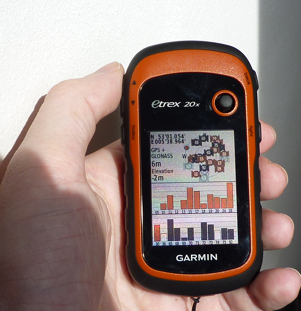
I also had an explorist 210 and my etrex 20x (same screen as your 30x) is miles better. In the picture you posted it looks like: it's indoors the backlight is off on the GPSr The GPSr is laid down at an angle, the nuvi / phone are propped up. Here is an indoor picture with the backlight on 100% on both devices In outdoor conditions, I can say that the GPSr is very readable as long as the sun is in my back (shining onto the GPSr screen). Here's a sunlight picture with backlight off If your GPSr doesn't perform like this, i'd say something is wrong.
-
Multicache on Garmin devices
stefanwilkens replied to stefanwilkens's topic in GPS technology and devices
Very informative, thank you. -
Multicache on Garmin devices
stefanwilkens replied to stefanwilkens's topic in GPS technology and devices
@HHL do you use a specific way to export the waypoints to your device? I see they are named Q1 <question>, Q2 <question>... is that a custom GSAK name or something? -
Multicache on Garmin devices
stefanwilkens replied to stefanwilkens's topic in GPS technology and devices
As far as I'm aware, and I think HHL confirms that for us, navigating to a child waypoint while still being in geocaching mode is simply not possible at the moment. Even worse - the GPS isn't even aware that these waypoints are children of the geocache, they are just imported as random waypoints. What HHL suggested was a "quick" way to navigate to the waypoint and then relatively quickly jump back to the geocaching mode to read the descriptions. This is possible because the Montana devices have a quick profile switch, something the etrex devices do not have. But it does involve leaving the geocache mode, which is not ideal - but workable I suppose. On those devices anyway. And just to clarify - yes, we want garmin to give us these multicaching features. They have them available in their android based devices, bringing that to the Montana / etrex devices would be great. They advertise "paperless" caching but they could do a better job here I'd say. The only thing we can do is request this feature from Garmin, here: https://www8.garmin.com/contactUs/ideas/ -
To be honest, the user manual for these devices is also very minimal - you really have to dig to find some of the features of this thing. The on-line owner's manual has a little more information that the tiny books they give you with the device: https://static.garmin.com/pumac/eTrex_10_20x_30x_OM_EN.pdf
-
On the etrex, you first have to define pages - by default there is only one "page", which is the main menu. This is why back ends you up on the main page by default. Op will have to define pages in the "Page Sequence" area of the device settings. By default, only "Main Menu" is there. After adding more pages, the "back" button can indeed be used to cycle through all of them.

-
Multicache on Garmin devices
stefanwilkens replied to stefanwilkens's topic in GPS technology and devices
This is a nice approach, I guess you are using some kind of GSAK export macro / smart name to modify the waypoint names? (Dutch I see!) I have been doing something like this as well, but the problem is that - once you start navigating to a waypoint, the GPS doesn't realize you are navigating to a "Geocache" anymore - and the "paperless" (hints, description etc) become unavailable. Nice big screen by the way, that's a montana device? -
Multicache on Garmin devices
stefanwilkens replied to stefanwilkens's topic in GPS technology and devices
Looking at a random multi with several predefined stages (obivously for puzzle stages this can't work, in that case we can use the existing "Enter next Stage" feature) I can see this: GC4T4RJ - Cache ID P14T4RJ - Parking Waypoint 1 Q14T4RJ - Stage Waypoint 1 Q24T4RJ - Stage Waypoint 2 Q34T4RJ - Stage Waypoint 3 Q44T4RJ - Stage Waypoint 4 I'd say that's fairly easy to implement? If there are more than 9 Stage waypoints, the prefix jumps up one letter. So Q1...Q9, R1... etc. It would have been nicer if waypoints had a stable type of prefix (eg stages are always S, parking always P, virtual always V...) but even with editable stage prefixes, I think this is workable. That said, the logic has already been implemented in the Garming Geocaching app for their Monterra device - clearly it's possible. Even just a screen which lets you select waypoints releted to the current cache would be a huge improvement. -
Multicache on Garmin devices
stefanwilkens replied to stefanwilkens's topic in GPS technology and devices
Even worse, the description of the extrex 20x states: However, the "Enter next Stage" option they provide for Multicaches requires exactly that!
.png)


