


7rxc
-
Posts
2408 -
Joined
-
Last visited
Posts posted by 7rxc
-
-
My query exactly... right to the GPSR model... take some time off and the world moves on... maybe time to buy a new GPS and watch as it goes obsolete a few months later...
Thanks to StefandD for the comments I'll have to see what is up that way... I think I have it all on my OLDer computer... might even work... for this OLDer cacher... ha.
Seems to me there was... long ago... another popular program that did this kind of thing loading caches that is... but also not direct... but it was outmarket stuff...mmm.
Getting OLDer... don't remember quite as well any more... was that the GSAK or something like that. but it was for sale... and complex to boot... I have to look for that as well... only used it a few times.
Meanwhile as cerberus1 says... going back to old school for now... but it's already too late for more than one...
I also do the condensed hand printed notes for field use... I've always done that, even sketch map of the site if it's a navigation nightmare... just hand sketch the landmarks from the air photos... Did you know that you can often trace them on a paper over the sreen... but gently so as not to harm the screen... you can also set a screen capture of that into your camera or even one of those pocket radios people have stuck to their faces these days... if it has image storing... good offline reference... you can even add marks on the picture... for more info.
For now... where is my P.E.N.C.I.L. ?
-
Also got one... but since it is being dealt with I'll just sit back... and read the replies...
Glad to see people are on their toes.
-
I'm not sure why I did not see the sticky 'base' thread today... perhaps it's just been more than xx days old... but it always has been there regardless of the filters.
Anyway: IF you see this note... If you can't see much in the way of threads, on the Ham Radio forum page (not in a thread), look down near the bottom end of the page and look for Click here to show filter options, over on the right side you can set the filter for how old you wish to view... try starting with View All and then you can adjust it as needed after you have a look around.
Edit: Don't forget to use GO to save the change. Sorry!
Doug 7rxc (VE7RXC)
-
I can report that there are several active in the East Kootenay part of British Columbia.
Not that many ever talk to one another directly, but we do use it as a means of contact out there in the void where cell phones don't work well.
I believe it has been said before on here that the reason for the forum was that Hams were early adopters of GPS technology and were glad to have something else to do with them... Many of us were in SAR groups to boot and comm needs there were also tied in to GPS tech. Anyway, the forum came to be and survives... since it does not take up that much space and serves mostly to let people know who the others are... I can also state with fair assurance, that I see lots of people occasionally let slip that they are hams (or have been) in the course of reading the forums, while not having 'registered' into our base thread... which reminds me, I once years back attempted to count the number of discrete callsigns in there... probably a slightly bigger task than 7 years ago. Problem was to extract the text... then mine it... never did get a handle on that part.
Regardless, it is here and serves that function of recognition. Most of us are more interested in Geocaching than talking. Most of the threads here seem to have died to to the lack of interest by the OPs. FWIW.
Edit: For JanekGeo, If you look at the lower part of the Ham Radio page... 'Click here to show filter options' and open up the filter to SHOW ALL threads, you will get a better look at what has been on here.. quite a few threads, some which discuss your question.
Doug 7rxc (VE7RXC)
-
Thanks for the tip, palmetto.
My problem is that the place where I want to hide a cache involves a decent hike. I would rather not hike out, place the cache, find out I can't put it there, and then have to hike back in to retrieve it. Once I move the cache, the cycle starts all over again. For places I pass by every day, it's not that big a deal.
Mystery caches are supposed to be with in 2 miles of the ? icon on the map.
You could submit a page for coordinate check, explain what you said above, and ask for a wider check for other caches. The reviewer may, or may not, admit to caches in the area - IF they think you are trying to 'Battleship' a nearby cache.
There can be a twist to that rule, the mystery may be a multy as well.
I am currently working on finding one in which stage one to two is about 140 miles. Possibly ten stages. Word is it is 500 miles.
IF the cache is an unknown/mystery with FALSE coordinates then the final has to be within 2 Miles of the posted coordinates. In that case there is NOTHING to find at the posted coordinates related to the mystery.
A multi would have fewer if any restrictions on distance away as long as SOMETHING is at the coordinates posted.
It should list the distance expected to travel to the final as a gesture... given costs these days... or risk getting lambasted in the logs etc. Anyway the difference is in what is or isn't at the coordinates on the listing as far as what icon the cache gets. Multis are just that and unknown/mystery can be either true or false coordinates as needed.
Either type could be a puzzle as well or just a cache.
The OP has a bigger misunderstanding in that they missed that what they were given several times was the instructions for checking the coordinates availability WITHOUT having to place anything, but might have to select new coordinates after listening to the reviewers reply. Doing a search based on the coordinates they have will give a listing of even PMO caches in the area and their directions away... of course multis and u/m caches have the final concealed... and u/m should have a disclaimer of false coordinates on the page...
Doug 7rxc
-
So what you reckon it meant before there were ads?
That they were trying to get hits on the site in order to be able to sell ads?
Doug 7rxc
-
Well, the curved surface didn't work out. When I actually got to go back and take a look, it turns out that it looks metal but isn't, so no magnet based caches there.
Still, sounds like overall it shouldn't be a big deal. I may increase the difficulty a half star higher than I was originally going to rate it.
I maintain one cache on a very large object... we had a problem of people removing the cache container and magnet but then hurriedly slapping it back in place without 'sticking' it... problem for me was that it either dropped off onto the ground or slid down... leaving no idea where it belonged.
My current solution was to put a large ring magnet at the desired location, the cache has NO magnet, but does have a steel washer firmly attached to it. It sort of centers itself on the ring magnet without too much help.
I adjusted the size of the washer to give a firm but not excessive resistance to moving, the magnet is large enough not to shift on it's own. This seems to keep it mostly in place or at least close by. The gropers still manage to drag it away from where it should be, but not anything like early on. You don't say how big your container is, but this might work for you with some thought... and it saves on finger bites as well since the magnet should stay in place... should that is... if some one moves it they are the bitees and probably deserve it for not reading the cache description and my occasional hints.
Doug 7rxc
-
Does "that the weird stuff some observe" include shutting the GPS down when you cross a RR track?

I don't know about other models, but our SAR group had some eTrex Legends that had really weak springs in the battery compartment... I think those could have done that... until you stretched the springs out a bit to increase the tension.
The also liked drawing lines across the screen and once in a while, fading out of view.
So who knows what's possible?
Doug 7rxc
-
I use low self-discharge NiMH batteries (Eneloop) in my Oregon 600. I've not noticed any loss of accuracy or anything strange when the batteries get low. Nor any interference from other devices or power lines etc.
I could see that if (*IF*) a GPS had a feature to switch to a power-saving mode automatically when the battery fell below a given level that accuracy could be affected. To the best of my limited knowledge, though... none do.
What many devices have when set for rechargables... is a circuit that monitors the voltage level.
You don't want them to drop below 1 volt per cell in most cases. Nimh batteries for example start out (fresh charge) just a bit higher than 1.2 volts per cell. It is high because of the required charge voltage, and fairly quickly drops to the 1.2 volts level. Even in use a common type Nimh will hold a near constant voltage until it is about to 'die'. Then it drops quite quickly. The monitor if it exists watches for the sudden drop off to begin and shuts the device down. I've always suspected (not proven) that the weird stuff some observe is due to the monitor being less than optimal in its settings or the same for the battery cells. I'm not an expert there, but they are strange creatures in my mind.. I have 4 that became totally inert when 'lost' for a while... and needing a recharge. 0 volts and no sign of taking a charge from the factory charger... I tried an experiment to see what happens using older NiCd procedures for a start point of experimentation... end result is 4 batteries that hold charge quite well, and often at a higher voltage longer. I don't use them for critical stuff, but they hold up for non critical tasks while I watch. Add that they were all (including the ones I use caching) bought in the late 90's on sale, and I'm happy that any are working. They were bargain type quality... don't see them around any more though. I do know that slow charging is better than fast though... chargers all vary in specs and quality.
Doug 7rxc
-
I use rechargeables in my Oregon 450 and it seems to work fine. They don't last as long though.
Just a thought... in the past I've found that people start out with alkaline batteries 1.5 v, but later switch to rechargables, say NiMH which are nominally 1.2 v... BUT forget to check the battery type settings. This can cause the device to show low battery early on. There are reasons for that, but it is techy and not a quick answer... Just check. Also make sure that the batteries are freshly charged... if they sit a while, they can self discharge or simply lose charge and thus deplete fairly quickly. Sometimes happens to me when I forget to top them up after a caching layoff period..
Hope that might help.
Doug 7rxc
-
Either/both Chrome and IE are the likely suspects.
snip%<
The most trouble-free browser seems to be Mozilla Firefox.
I've heard there is a fix or work-around for Chrome, but I don't know it.
snip%<
There is another alternative (for Premium Members):
Use Pocket Queries, download the data and load it directly to the GPSr. You do so directly from the computer, not using any browser or add-on program. Thereby eliminating such problems.
That is about got it... I've just been through it on my systems, and Firefox presented the best solution.
The problem is with IE and Chrome dropping the NPAPI usage. Firefox supposedly does the same thing through JAVA.
thus in MY case, Garmin Communicator now works... The same is probably true of the others in varying degrees, I just don't use them. Took me just a bit to get Firefox and Java to work together well, just setting and enabling things.
Chromes work around seems to now ended with the newest version, 45?, and so did communicator in late April... Mine hung on for a bit until my system updated itself. So go Firefox... I don't know why I tried Chrome in the first place, but I did like many of it's features. Perhaps things will straighten out as W10 kicks in... I assume there is a reluctance to do anything for W8.1 and much less for Vista (me). Would be helpful if the various Communicator programs were made OPEN.
But only if the companies are truly casting them off. I agree that PM would solve the problem for many. I may eventually go that route myself after all these years, but I find the money better spent on things I need right now. I am finding more available, but it's still just getting by... and I don't get that much caching in either, but enough.
Doug 7rxc
-
How about TB53PN2 2nd on the list of TBs owned...
Possibly, except that the same tracking number can't be both "Herlieke's" TB and the OP's "stolen TB" My wild guess is, the OP mis-typed the tracking number, activating an unused one.
Herlieke's TB is TB53PN2 and the OP mentioned TB5WK9Y as the one 'created'. That assumes that the first one is indeed the 'stamp'. Will be interesting to hear how the second one came to be. Also to see where the reference was originally... The first is seveal years old and supposedly the new one is quite recent. Don't reference numbers get created sequentially, or are they hard linked to the TB number... I don't know that
part. I thought they were generated at activation, but I'm known to be in error sometimes.
Doug 7rxc
-
But I also don't see a "Herlieke" TB that could be the culprit.
How about TB53PN2 2nd on the list of TBs owned...
Anyway... how long have these things( Trackable Stamps ) been around?
I guess they are not any more invalid than Vehicle TB's or trackable packs, hats, dogs etc.
The problem, if any, is that that they end up in logs for anyone else to discover... not just the person who sees the stamp. Is that proper? In Europe or anywhere for that matter. I can see the ones that DON'T have the tracking code as part of the stamp in the log. You discover the physical stamp to get those ones at least, like a hat or sticker on vehicle. What happens to those in logs like this one. The OP's photo gallery has many that clearly show the trackable numbers on line.
At least in this example they are covered up by fingers/thumbs. If it were me I'd blur the gallery images or remove them, but it's already way to late anyway probably.
The logs, at least you have to see the stamping, but better not to propogate photographically.
As already stated, it appears to be a glitch there, best sorted out by GS. Depends on what the OP actually editted... they won't have a tag or anything, that is the mystery.
Doug 7rxc
-
A friend informed me that he couldn't get on the forums because he's not a premium member... is this so? That's crap, if so..
I think the point has been made, he is welcome.
One thing that sometimes confuses people is that they don't realize that you have to log in to the forums separately when you come over from the GC site (Community options). The other thing that gets them is that they sometimes don't realize it is the same username and password. I know I got burned that way, many years back... thought it required a separate registration, or paid membership as I recall.
Doug 7rxc
You can even make a 'signature' with a little effort, but the official one is a PM perk.
-
I've been around since 2008. And for most of that time I've used the page listings for most of my information.
For the most part, the information there is more than adequate, although the two map thing (meaning the little one up nearer the top -overview?) versus the one showing the cache location seems redundant.
I would like to see the D/T ratings reviewed... Difficulty is just that, Terrain should stick to just that.
Accessibilty to people with diabilities would be handled by the Handicaching ratings, since they address both different disabilities and a range of ability within each. Always considered it a bit odd that most people can't get beyond summing it all up with wheelchair accessible... what about the others?
A place to describe technical skills and gear might be nice, but that might just be a part of the description text.
Refining attributes (simplifying them to class might do well). Right now they get confusing. But that is when one is reading them, not searching with them as filters. Readers might just want to see much broader topics... ie. HAZARD Present... and a matching box placed into the description with an explanation alongside the attribute symbol. Right now they hide over in the corner.
Which brings me to...
GS might consider this... the situation of encouraging people to create a cache page with all the bells and whistles (whatever they be) for people to read, use and enjoy... and then creating the means for all the masses to simply bypass the page and only download something that they don't even look at... just head for the coordinates uninformed. Sure some caches are fine that way, but others need to be read. Now the best way is to put it in the unknown/mystery category so people know they should read it. I guess that EVERYONE now is wired to the web and has the latest gear, but that is not the case with many in reality.
But it is something to consider... overall, I'd rather have an official policy of READ them. I only own one cache, and I know that while it is a traditional, there is lots on the page about that and it's neighbours.. that really need to be seen. On the other hand only one person has found it last I looked.
And I'm the only one who found his... but that is how I found out about things up there, and why I put mine where it is.
7rxc
-
I was thinking about this summer -- maybe next -- of geocaching from St John's, Newfoundland to Victoria, BC. I figure that, although I've been to 48 states and 19 countries, I have never set foot in the Great White North. So why not start seeing Canada by seeing a huge swath of Canada? Anyone done such a journey in one stretch? Figure I'd take about 10 days to do it.
Hi... glad to hear you are thinking about such a journey, but... I've been doing it using various means over a lifetime and still have just scratched the surface... and I live here in Canada. In other words, 10 days is fine, but you won't do much more than drive, eat, sleep and drive. Of course you said see a swath, not the whole place... and I hear that. Just a caution on my part... and the other question is are you counting the outbound trip from CA in the ten days? You might get advice on lots of places... but ask a bit more locally. I can suggest using the hwy 3 route if you come through South Eastern BC, lots of good caches around from Medicine Hat AB all the way through to the coast, and you can turn homeward at many points along that route as well if running behind a bit. I went down to Ontario (home once) and cached for 5 days each way from here... barely touched the selection but we were on a tight schedule and had a vehicle in need of much attention to do so. Speaking of which, factor in gas prices if you drive, they are higher in Canada. But your choice of vehicle will count in that. I tried to do one cache attempt every 30 minutes of driving on average, but that was as much to relieve my back as anything... but weather has a way of changing things... speaking of which, the East is still buried in snow and often is into late May. This year they may exceed that one. On the other hand in BC it is spring and there is way below normal snow pack... just quick little dumps and gone. If you don't like the weather wait 5 minutes is the saying.
Hope that helps plan, not discourage... I've done most of that by bicycle as well.
Doug 7rxc
-
Attribute or simply a note on the page... the real question is do people even look at pages before going out? When you go to log is a bit late in my book.
Sometimes I wonder why they promote page creation and then discourage people from going to see it.
Doug 7rxc
-
I'm reminded of when I was in the middle of several tree limbs and I opened the foliage to call out to Mrs. Cat, "I can't find it"! Mrs. Cat looked over to me and saw the cache dangling on a line right next to my ear.
That happens quite a lot with micros... For me it is usually self found, but not until I've about given up and sometimes when I have.
Just a few weeks back I found one, fairly obvious as well. This was on my 3rd or 4th try, and since GZ was proving 'empty' I had broadened my search area quite a bit over several visits... just had made the decision to call it that day as well, and had knelt down to pack my backpack and have a snack. While closing it all up and securing all my junk, I simply raised up my eyes a bit and... there it was, right in front of me. Not even concealed much. Sure it was about 40 feet from where the GPS said, but it was almost as I had imagined it would be, hidden in plain sight with just a touch of cammo. Done and logged, and it was the original, since the log went all the way back to day one. Plus it was rated correctly, just a little b----r to find if you didn't relax a bit.
I find that is a commonality to hard to find caches, sit down and chill a bit, maybe have a snack and / or check your batteries in the GPS or anything but look for the cache. GZ often changes position, in all I had 3 distinct locations on this one, one was closer and that was the one where I found it. Little narrow valleys and trees will do it to you every time.
Now if I could just find the rest of the ones I couldn't on that trail... hmm.
Doug 7rxc
-
Glad to hear you weren't hurt, Doug. ICBC will cover the damage to the truck....I hope! Probably happened was due to the stress and work of moving. Apparently, moving is one of the most stressful things we do. Take care, and all the best in your new home.
Thanks for the thoughts... actually it was fairly minor, but raised a lot of WHY questions... Anyway, I'm away from the stress of being put out, and am starting to look for a new place, but cheques keep avoiding me in the mail. Old one no good, new one a dream etc. Using a GD address for one group and a friends place for the DL etc.
Funny side note was a chap ribbing me about living out of my car at my friends place (I'm working on both truck and his place while waiting for things to clear a bit more). He just couldn't understand how a set of circumstances could put you out of your home so quickly. The other morning he got told the place he lives in is being sold and he has to move out asap (within the rental rules of course). Karma... ahhh.
Had he had this experience a little over a month ago, we both could have had a place (mine) but no way.
Another good thing... my truck had taken to sucking gas in unusually high volumes... round trip was 20 bucks easy (to the storage and back)... while safety checking the truck, I found a broken vacuum line (main source) and the lack of vacuum for the EC system on the engine was messing up the computer's efforts to work it out.
Just cut off a half inch and put it back... did 3 trips for 20 with gas left over tospare... Oh yes.. the first trip was to get the windshield replaced and move some boxes... Still contemplating the nature of what could have happened, that did NOT. Even found a new cache I didn't notice locally due to being busy.
THAT is what I did last weekend!
Doug 7rxc
-
Been busy packing and moving house. On the way home from storage last friday, I started feeling lousy and decided that getting off the road and stopped was critical, started braking and saw a convenient road to turn onto and stop. NOT! Almost there I passed out and the truck went on it's own way down a small embankement and on into the woods until it high centered on small brush (missed a tree by inches there, but not on the way in. Busted windshield and some dents, no real injury, but still working on why it happened. Was able to extract it next day. Just a drive out other than the high centering.
Oops! forgot the photo. Back soon.
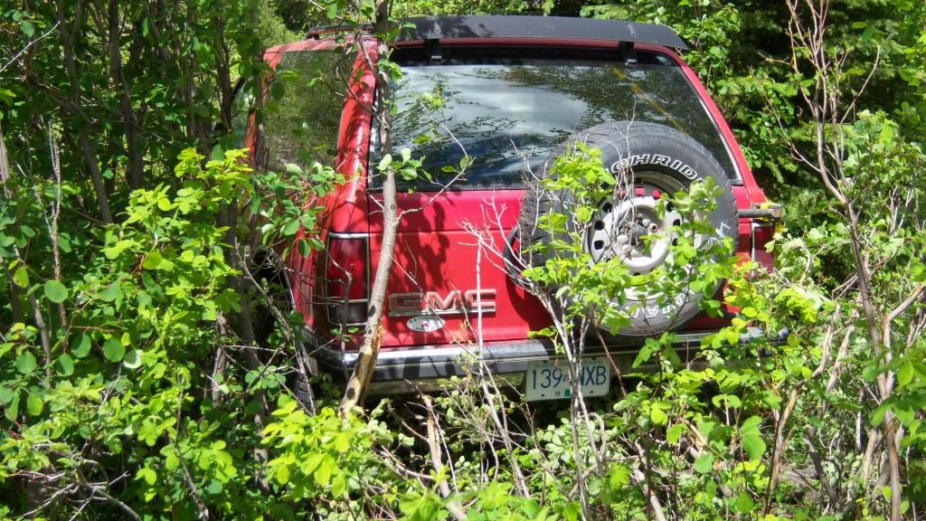
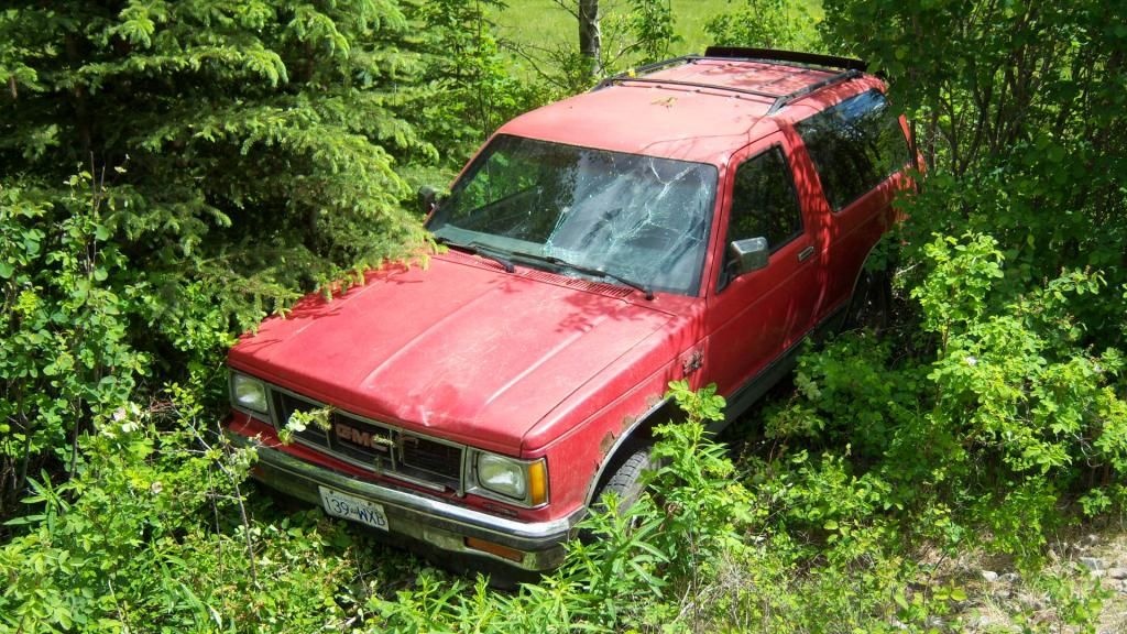
Not a good way to end a week of moving... other than that no one (even me) was hurt. Slows down the caching a lot.
Doug 7rxc
-
Wonder what the school thinks about this new CASH hunting craze... forget kids, where it is happening, you have crazed mobs searching for money based on clues posted on social media. The news video I saw showed one group trashing a garden area (their own? doubt it). Will be very interesting to see what kind of backlash this one causes for Geocaching and other 'searchs'.
Anyway, on one hand it's nice to see someone is looking out for someone else (unless it's a fraud). But I can think of many things that are more 'risky' to kids than caching... like the new craze... not nice to get in the way of a determined adult. Reminded me of "It's a mad, mad, mad, mad world" (count approximate).
Doug 7rxc
-
Ah! Then this one is an agendum?
I am hiding this geocache as a project for my eighth grade science class. Our goal is to teach our fellow geocachers about environmental impacts. I am going to teach you a little about acid rain. Though every living thing on earth needs water to live, rain has become a dilemma in many parts of the world. This is because of pollution in the air due to gases from factories, cars, homes, and other human activities, rain is becoming a threat to the life of every living creature. This occurrence is called acid rain, a form of precipitation produced by the build up of fossil fuels, like coal and oil going into the air after being burned in power stations or factories, and even our homes. Once these fumes reach the air, they mix with the clouds. Although human pollution plays a big part in this, nature can cause acid rain too, such as volcanoes, when they erupt, the gases coming out are acidic. We can help decrease the affects of this and eventually remove the problem completely by walking or biking instead of using cars, avoid smoking, turn off electrical devices that are not in use. Doing these small things will mean big change in time if we try, so remember when you are plugging out your TV when you leave the house, or put in some footwork for where you want to go, you are helping the earth BIG TIME.This one definitely has a stated agendum... the blue part... however it does not offend me anywhere as much as the comments about the caches needing attention/maintenance. Wonder if they will be archived after three months minimum to fit the intended permanence guidelines or be simply abandoned unmaintained?
If the point is to define where an agendum becomes one... the first example stuck to 'facts' but the second did not in that one line. But I agree where do lines get placed properly.
Doug 7rxc
-
One obvious thing to do would be to LOG the FIND on the archived cache page... You did find it... just sign the log or a new page in the container. Then write a Found log telling the story... to complete the history of the cache. ( you could just edit down your post here). The archived status does not block this at all unless it is locked to logs. Late logs are common on archived caches found before and after archiving IF they are legitimate.
In fact, you might just find your missing CO, since people do occasionaly read their old cache pages, or might still get notifications... or not. Anyway it would round off the story of the cache. I'd even consider using a digital camera to photo the log book and upload the photos to the page as well. After that the old container would probably be disposed of. Also it's possible that someone reading this topic might be able to shed light on the CO... people at that time could change username by creating a new account most often, or they may have had life problems, including death. Many just burn out or find new interests...
At least you have a great story for your first find, so log away.
Doug 7rxc
-
There are several map types available on Cache Description Pages... Mapquest seems to be the default, but over on the left side you can choose to view in others... try the OSM there and see if it works differently. Not sure about the general map on the Hide and Seek a cache page... despite using it daily, but I don't think that is selectable... other than PM's can opt for GM I think... even those can be edited via Google somehow.
I edit local OSM maps here and most appear fairly quickly even on the MapQuestvariant... and even some of the others that use OSM to update... however not all at the same rate. For my GPS(es) I use the OSM downloads from garmin.openstreetmap.nl and they sometimes take up to a week. Different story though since those are processed by independent people/groups.
One thing I find annoying about OSM editting is that often the site makes updates containing the same errors I fixed recently wiping out the correct stuff. They seem to do that from government data in large blocks. hmm.
Don't care to do that over and over again. Thought they were supposed to consult over conflicts to resolve.
That and they have progressed way beyond the ability of my GPS to keep up with display items... the newer E20 displays the same map very differently from my Map60 when it comes to trails etc. I'm sure the source could change by type of unit, but why? He probably has a newer one.
Edit: Just went to look... using the Hide and Seek a Cache page, 10km of Port Lincoln, SA, then Map this location... The Mapquest OSM does not show your corrections, but, at least for Orabanda/Kurara, the map has been fixed already on OSMdefault.. you CAN switch maps on the upper right (stack of maps icon)...
Good luck with them sticking, most do that way... the MapquestOSM takes a while since they update on their own schedule and so does GS I believe... but it should be soon... Also you might have to zoom in or out for some things depending on how good you are at editting, I tend to miss zoom levels a lot, but only use the online editor..
Doug 7rxc
Coordinates miles out
in How do I...?
Posted
I still have my Garmin 45XL... works, but is a pain to try geocaching with, although I did until 2010... when I got a Map60cx.
Most we had at the SAR hall only had DD MM.mmm. The 45XL only had DD MM.mm and we used it under SA... really hard to pinpoint...
But prior to the dropping of SA, the US govt would only allow indicators to show about the same accuracy as a topo map... as I recall...
And that was long before WAAS and no one had Glonass either....
I do agree that his image shows 4 decimal places after the minutes... Wonder if where he bought that phone they didn't have to deal with US rules...
or if it uses one of the other geosat systems... like the Chinese one...
One thing though... having that 4 decimal place would have driven me crazy... the third one keeps moving around as it is... newer multi system receivers and correction systems might have slowed that down... but when there were fewer satellites, the calculations were always changing...