

JBnW
-
Posts
1225 -
Joined
-
Last visited
Posts posted by JBnW
-
-
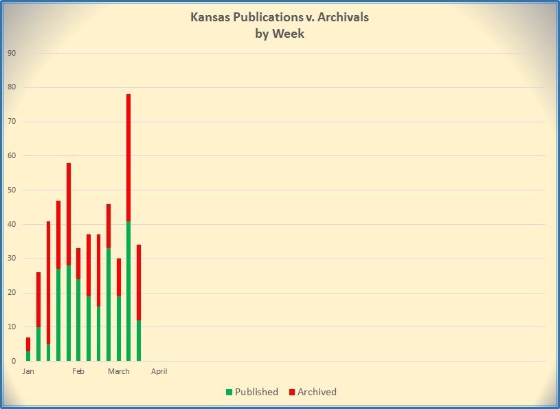
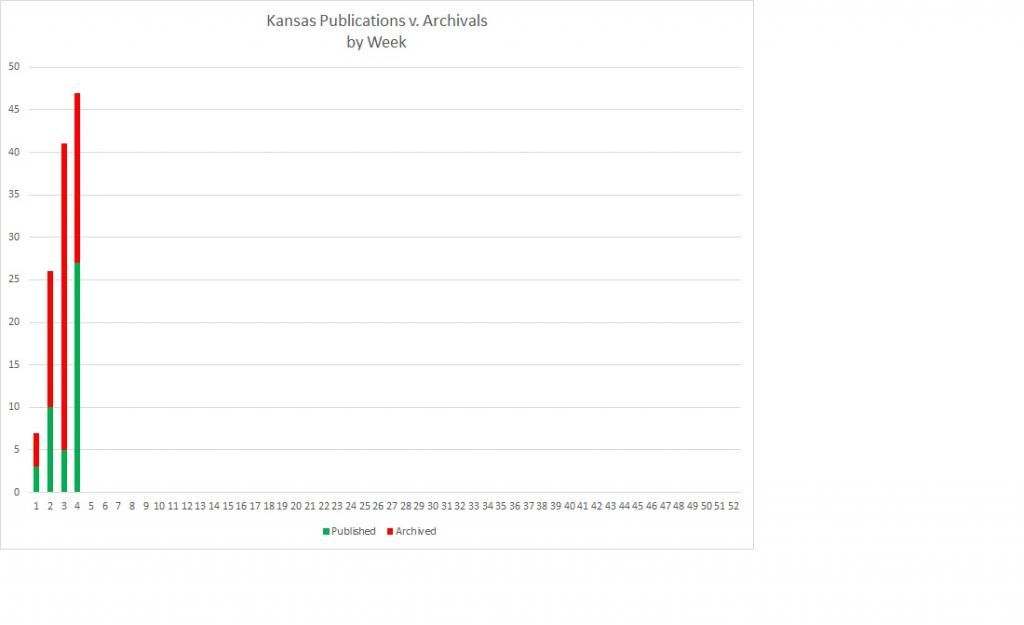
In the event anyone is still tracking this, or interested in it, here's an (almost) quarterly update of the publication-archive rate for Kansas (see post 27 above). The result of all this is that, 12 weeks into the year, the net change in total caches available in the State in 2015 is 0 (Zero, zip, zilch, nada), and has ranged from -38 to +10 on a weekly basis.
-
I generally use the Map for navigating by road, with 2 small windows displaying speed and power (battery level or power cord). Once on final approach, I'll switch navigating style to Direct, and then switch over to the compass page, which also has 2 small windows for speed and distance remaining. That usually gives me an idea of the general location of the cache, then I go find the next local spot to park and make the final find using the compass page.
-
Science Bob has them in 5-, 15-, and 30-packs.
-
One other bit of data I didn't mention about the graphs above is that, in 2014, there were 1,101 archived caches (sans Events), 1,419 published caches (sans Events), for a net change of +318 for the whole state. Of course, publications can only be counted within one year, while archivals can apply across all years. The archiving of ~1,000 caches in a year seems like a bunch, but that stays generally consistent (900-1400 per year) throughout the extent of my data set. Maybe it is a lot!?
-
Hope this thread's not too dusty to respond to.
 I have been watching the same thing happen in Kansas for the last year or so, but didn't keep detailed notes. Over the holidays, I spent some time grinding through a GSAK state-wide database and came up with this display of active caches (sans all event types) available by Year and Type, totaling 12,202. I discounted the events as they are intended to have short lives, and be archived quickly. So, as of Jan 2, 2015, these would be the "survivors":
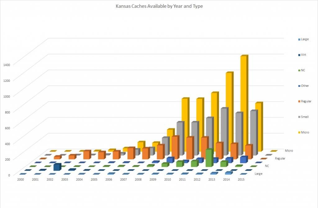
Note that the ~50% decline in micros placed in 2014 equates to a ~25% net decrease in total caches available placed in that same year.
Since the start of the year, I've been keeping those more-detailed notes, and this graph shows weekly new publications and archivals (again, sans events) for 2015. Yes, a limited data set so far, but very consistent with observations from 2014. This is a net decrease total caches of 31 so far in 2015:
-
I've got my PQ and it's zipped. How do I get this onto my GPS device?
Any standard unzipping utility will, well, unzip it. It contains 2 .gpx files. As you did with the download single cache method, plug your GPS into your computer and copy/paste the two files to the :/garmin/gpx folder on the GPS.
-
More info needed...
HOW do you load it? Send to GPS or Pocket Queries?
Using an SDcard or no?
Those "more" that you downloaded, how far away are they? Near or more than 50 miles distant?
How is it that you "see" the geocaches -- on the map screen or in the geocache list?
Available memory? Your computer can tell you how much memory space is available on the unit/card.
That unit is supposed to hold something like 2,000 caches (I think).
I'm loading these using "Send to GPS". All of the items I've downloaded are within 10 miles. I see this in my geocache list. When I check my memory there is plenty of room. The memory is supposed to hold 5000 caches.
Pocket Queries are your friend, here. One GPX file with up to 1000 caches.
-
Other than the agenda possibility, an easy way to simply publish the coordinates on a Puzzle cache is to do a simple coordinate conversion. Not sure if the Intro App can handle that task.
-
Last winter, I completed a challenge, and went to find the container to finish the deal. My son, who has his own account but had not completed the challenge, was with me. We both signed the log, then I logged a Fount It and he logged a Note with his intention to complete the challenge. When he completes it, he'll probably create a new Found It log based on the day of completion, and mention that the signature on the log sheet was on such-and-such day.
-
I didn't forget the Help Center. It is linked to from the Geocaching 101.
Also, the only thing I agreed to on this site were the Terms of Use and Geocache Listing Requirements / Guidelines. You are required to check that you have read and agree to them before you are allowed to hide a geocache.
Just a point of clarification, the only thing anyone is "required" to do is click in a box, the meaning behind the checking of those boxes is many times missed. Witness the number of caches placed that are contrary to the guidelines.
Maybe the OP should add an option for "G: I clicked the box because I needed to"
-
Once you've selected a cache and are navigating to it, from the Map screen press Menu > View Geocache > Show Hint.
-
My initial interest was to discuss what audience people target at when they communicate.
Don't worry CJ, I understood your question from the start.
As for me, the primary audience is always the CO to at least thank them for the cache, let them know its condition and that it is still there. Often I'll tell a bit of why I was in the area, what happened that day, etc., etc. If other cachers get anything from my logs that's cool but not the point. Only occasionally would I specifically include something for future finders, like a notice there's new construction in the area or something, otherwise I try to avoid spoilers. And my logs will always be in English, that is the best way for me to communicate. When I get a chance to cache someplace that has a different local language, my logs will be in English and I would try to keep it simple so the on-line translators don't mangle the translation too badly.But that's just me.
-
Problem 1: Haven't heard of that problem and am not familiar with that map. 5m could be that you're zoomed in too far and there's nothing to show...but that's a guess. Here's a good place to start for free Garmin compatible maps of your area: http://talkytoaster.info/ukmaps.htm
Question 1: What he said. PQs are your friend!
-
I've recently become interested in "lonely caches" after discovering that we've found a few of them. I don't even know if there is a Lonely Cache Challenge near us, but I've started a bookmark list to gather the info.
B.
Here's one: GC2WCBF "Near" is up to you.
-
With that kind of accuracy, cachers will be absolutely certain under which lamp post skirt the cache is hiding...and the find will be just as rewarding.
-
You would need a third-party software program, like GSAK and others, to filter caches in that manner. That would be the automated way. The manual method would be to go to your profile page and click the "Search for Geocaches > Filter Out Finds" to bring up a list of caches near you. On that page, click the "Last Found" header (twice?) to sort. The oldest unfound caches will be listed first, and you could build a bookmark list for those to make a PQ, or download individually. If you're doing this for a "Lonely Cache" challenge, keep in mind that one find on one of these caches by someone else can mess up the whole manual approach.
Hope this helps.
-
I see that the OP has found caches in the Tualatin, OR area. If that's close, and you can wait just a bit more, Cabela's is opening a new store very near you this fall. I think the next closest would be Springfield. Cabela's often has sales on GPSers, and right now has the 62st at $249. I normally wouldn't advise getting an "st" unit, as there are plenty of free topo maps available...but if one were in the market for a new GPSer...it's a pretty good price. Cabela's also used to have the 62s on sale for $199 frequently, but I haven't seen those for a while, maybe they're sold out or something.
-
#3 With my MAP60CSx I can choose "Follow Road" or "Off Road" when I select a geocache to find. I can't find the "Follow Road" with the 64?
I'm guessing that the logic on the 64 is similar to the 62, if so, from the Main Menu>Setup>Routing>Lock on Road. Or something similar to that. Also check out the Profiles feature (if the 64 still uses those...Garmin doesn't say
 ). If profiles are available, you can use different settings for each activity (not locked on road for caching; locked on road for automotive, which map to display, etc).
 -
When you say "see", do you mean on the map display, or on a list of nearest? Is there any chance that the missing caches are more than 50 miles away from your current position?
-
Still working on filling in May 2000. Prior to that, it took us a while to fill in September 2000 and December 2000; we hit Christmas Cache in south Florida on our way back from Key West, not long before we left Alabama, and then I picked up Tombstone in Texas two months later during a house hunting trip prior to our move out west.
Now we are only 342 miles from Mingo, so we just need to get that one before we move next summer. But my real goal is to get Arikaree, since that's still the original container as far as I can tell.
And a gazillion times cooler cache than Mingo will ever be...IMHO. Hit me up of you're looking for some other caches for a great road-trip in that part of the state. I might be able to point you to a few.
-
I get the notifications for the area on archives and placements and the archives win. Sad
And that's what I've been seeing for a while now, at least since the start of the year. I would agree that total numbers are way up now as compared to 2012, but something else has been going on since January or so. For the two weeks after starting this thread, there was a net change (new publications minus archivals...not counting events) of -4 state-wide. And like baack40 unfortunately mentions, many of these are from long-time cachers archiving en mass. At least around here, this has been going on for months, several new publications every week, and about the same or more archivals to go with them leading to a slow steady decline. It paints a bit of a different picture of the "growth" of the game...sad indeed.
-
Photoshop
Why would I bother?
Here's a bigger photo from another plane...


~
Funny you should mention that....Ram Mount, 4th and 5th photos from the top.
-
About 60 miles WSW at N38 59.171 W97 37.000. Have been watching it wander aimlessly within about a 10 mile circle for a couple of years now. I did find a cache within about 5 miles of it two weeks ago, and this would be the closest.
-
My weekly updated PQs have now run. In Kansas, 17 new caches published, 16 "old" caches archived (published between 2009-2014). Net of +1.
 ). If profiles are available, you can use different settings for each activity (not locked on road for caching; locked on road for automotive, which map to display, etc).
The TB didn't fit so I ________
in General geocaching topics
Posted
...put it in the US Mail to a non-cacher friend who happens to live near the TB's destination.