


Warriorrider
-
Posts
420 -
Joined
-
Last visited
Posts posted by Warriorrider
-
-
New Oregon 3.40 firmware for the x50 and 3.40 firmware for the Colorado is out via WebUpdater! Just done a quick test and my Icons are back with Discover maps on the Oregon. Just about to test the Colorado!
Jon.
I just updated my Oregon 550t with CN 2010 and TOPO 24K Northeast to 3.40, and my street names are back. That's a relief.
According to WebUpdater, this update also adds Profile control for BirdsEye imagery, but since I haven't subscribed yet I can't test that claim.
--Larry
BirdsEye is now profile specific
-
I re-loaded my maps from internal memory on my Oregon 300 in order to gain more space for BirdsEye. My memory card is a Garmin 24K Topo card so I am stuck using internal memory for everything else. Anyway, I have street names on all of my maps, CNNT, Topo 2008, Garmin 24K, and Ibycus USA. To be honest though I am not sure if I ever lost the street names. I re-sized the maps right after the upgrade to 3.70
-
BirdsEye really needs to be profile specific just like all of the rest of the maps and not globally set.
-
Well I've confirmed on my Oregon 550 that while using beta 3.26 I'm able to download and display Birdseye Imagery. I've also got my street names and my daily archiving back. So for now I'm sticking with 3.26 until a standard release comes out that still has all of these features.
Good to know. Is it still set globally? On in one profile means on in all profiles and off in one is off in all?
-
I hope they fix that. It would be a great way to switch between aerials and (custom map) USGS topos.
My thoughts exactly

-
OK, so after upgrading my Oregon 300 to 3.70 and trying out BirdsEye I noticed that when going into map setup and enabling it in any profile will enable it in all profiles. Likewise if I disable it it will be disabled in all profiles. This does not seem right. I was hoping to have one profile set up just for BirdsEye just as I have one set up for custom maps etc. I e-mailed Garmin and this was their response:
Thank you for contacting Garmin International.
I would be happy to help you with this. I experimented with three
different units (Oregon 450, 300, and Dakota 20). Once I disabled the
BirdEye on each of the devices, then it was disabled on all three unit
will all profiles.
Unfortunately, it looks as if this is how the unit is designed. I
apologize about this inconvenience.
With Best Regards,
xxxx
Is this really how everyone else's Garmin's are? I had someone say that it was not globally set on their 550. Just trying to get to the bottom of this. It just does not seem right to me to have this set globally.
-
I tried this one out last night. From a great distance it looks cool like the screenshot above but not so when zoomed in. When trying to use at a more appropriate zoom level for hiking or caching all you get is dark green/brown background to the maps without the relief shading that you would see on the Garmin Topo maps. I removed it from my Oregon as it is useless for me.
The best answer I have come up with is to use TopoFusion and upload a white backround (use the +/- keys to remove all the coloring and map info from the map) but with shaded relief highlighted to my Oregon with a 0 draw order. With a topo map active in the Oregon you now have an Oregon topo map with a white background and shaded relief. This is way, way easier to see than the greenish/brownish background that you normally see as the background when shaded relief is being used.
-
Turn off relief shading and land cover is the best you can do. Details on how to make the map page more readable are here:
And you can have a white map background AND have shaded relief also. Iv'e been playing around with TopoFusion taking away all of the color from a topo map and leaving just a plain white surface with the shaded relief turned on and then uploadeding it to my Oregon with a 0 draw order. The results were my 24k Garmin maps with shaded relief and a white backgound instead of the very hard to see Garmin brownish/green shaded relief. This is so much easier to see while out on the trails.
-
Have you checked to see if you have the latest firmware?
-
I downloaded MapSend Topo 3D to an Sd card to use in my Crossover. It was the only option I could find.
-
This had happened to me two or three time when I had my MerryPlat too. The one thing that always fixed it was to do a clear all memory. You will lose your waypoints so you may want to save those first. Afterwards let your gps set with a clear view of the sky for twenty or thirty minutes.
It's been a while since I had that gps so I don't remember exactly how to get to that part of the menu to clear all memory. Good luck.
-
Beta 3.15 I mark a wayoint. Then I go to "Where To?" and it shows that the waypoint is 40 to 60 metres away.
Consistently
dadgum. I like betas but I shake my head that it seems that Garmin do NO testing what so ever - how can they miss these little things before putting out a beta? Don't programmers test their own code any more?
I doubt if it has to do with the code but rather your unit. If I mark a waypoint then go to "Where To" it will show that waypoint at 4 feet away or less. Consistently.
-
Two steps forward and one step back.
Other that possible battery consumption, I don't this the power off problem is a show stopper.
I checked the power off against the trip computer timer and it appears to be powering down correctly...except for the black and white screen.
-
I guess I just didn't wait long enough. But it is still a bug. I reported it.
JetSkier
I reported too
-
Just installed 2.99 beta and when I turn the unit off (Oregon 300), I get a half black and half white screen. It stays that way until I pull the batteries. Anyone else?
JetSkier
Same here. It does fade away though without pulling the batteries.
-
For anyone interested in a case for your Oregon that will go on your belt I have found 2 cases that fit the Oregon very nicely. Oregon must be removed to view but will protect your Oregon well. Both cases are not much larger than the GPS.
One is made by McGuire-Nicholas and is called the Cell Phone/2-Way Radio Holder. It has a stainless clip plus a nylon webbing loop, either can be attached to your belt. The inside of the case has a soft fabric; the sides of the case are expandable elastic. The case has a flap that comes over the top and secures with velcro to hold the GPS in, but the GPS goes all the way down in the case so falling out is not possible. Case is made out of Nylon and is black in color. McGuire-Nicholas model no. 656-770. Local Home Depot had on clearance for $3.00.
Second case is a soft nylon carrying case (Model no. LCS-CSQ) made by Sony for their Cyber-shot camera. Has a 2 way zipper for closure. Inside of case has a soft protective padding. Has a velcro flap pocket on outside that should hold 2 spare batteries. Has a nylon loop that belt would go through. Black in color. High quality case for the price of $12.97 at Walmart.
I have the first case and it is ok.
I have tried several cases (not that you see thru though) and in my opinion the very best case that I have found thats fits the Oregon just like it was made for it is the Clip Case for the Magellan Explorist. I have been using one for awhile now and I couldn't ask for anything better. It does not have any additional pockets but that works for me because I prefer to carry my extra batteries in my backpack when on a hike.
-
I have had the same problem a couple of different times and the only way to get rid of it was to delete the gpx folder itself. Disconnected the unit fired it back up the hooked it back up to the pc and reloaded my caches. All fixed.
-
You can also turn off the shading and land cover shading to to make the screen easier to see.
-
I use a free program called GSAK that helps me organize my Caches and also use the Explorist 500. I go to the geocaching.com website and "Build a Pocket Query" and have that emailed to me, then save the file into the GSAK program, open a database named whatever I want to call it, save those files into that database and then click on the GPS button (after setting up and letting it know I am using a Magellan Explorist 500) and click send waypoints while the SD card is plugged into my laptop. Then I am ready to go.
Once learned GSAK is the best way to go. But there is no need to remove the sd card from the gps though.
-
I can download the caches to my computer and put then on a SD card for my GPS (Magellan explorist 500) they download as a GPX file, but I can't get my GPS to recognize the file? Help Please.
Your gps will not recognize a .gpx file. It will need to be converted to a .gs file first. You can get Mapsend Lite or VantagePoint software to do this and send it to your gps. Both are free and can be downloaded from Magellan's website.
-
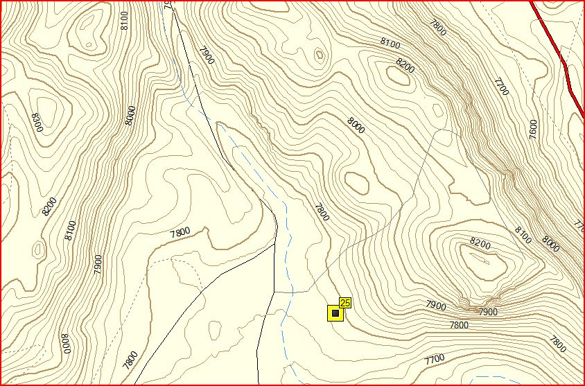
Here are some screen shots for that area from my Oregon. There are lots of different possibilities with the different maps and turning different layers on or off:
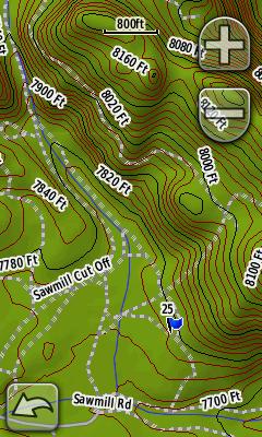
24K CA/NV Topo - sd card two state series
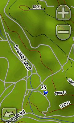
Topo 2008

Topo 2008 with CA Topo isolines from gpsfiledepot.com overlayed
-
ryanerb,
Here are some MapSource shots for that same area for comparison:
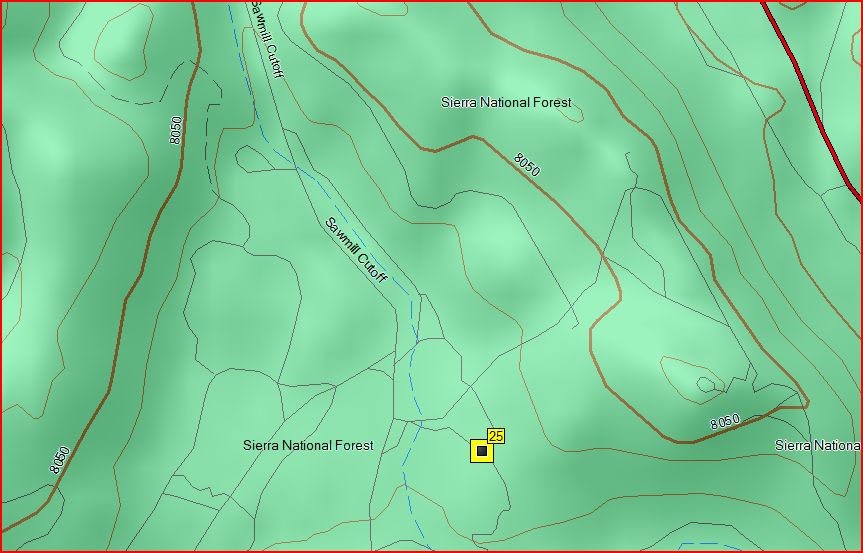
Garmin Topo 2008
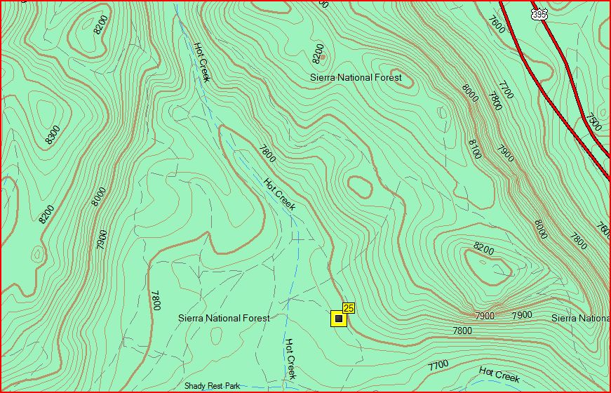
Garmin 24K Topo CA/NV two state series (SD card only at this time)
CA Topo from gpsfiledepot.com
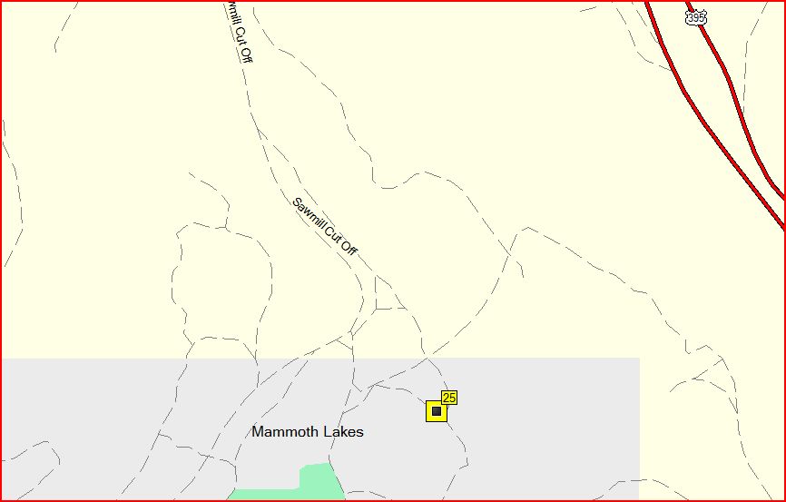
Garmin City Nav NT 2009
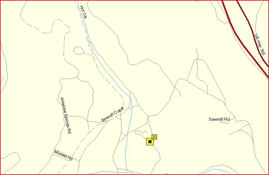
Ibycus USA
-
Those maps are routable. Either change the routing to "follow roads" in the setup or switch to automotiove profile which has it as default.
Garmin Topo maps are routable? Since when? I have never discovered a routable topo map!
These Garmin Topo maps are routable.
-
YES! . . . On the XL, and 600.
As near as I can tell the XL was Magellan's (as we knew them) Swan Song.
Norm
By Swan Song do you mean GIGANTIC GPS? That thing is like a cinder block.
Did the Meridian series come after the Explorist models?
The Meridian line was produced before the Explorist.
My First Impressions - Magellan Explorist GC
in GPS technology and devices
Posted
The Oregon has a Waypoint Averaging function. Not sure about the Dakota.