

FanMan
-
Posts
39 -
Joined
-
Last visited
Posts posted by FanMan
-
-
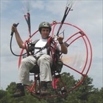
I flew out and landed my powered paraglider to an island to find a cache once...
-
I posted this on the other "new to hiking" thread, but it's appropriate here:
Boots... every boot manufacturer builds their boots on a "last", which is basically a metal replica of a foot that they form the leather around. How closely the last matches your own foot determines how well the boots will fit. Once you find a bootmaker whose boots fit your feet, chances are all of their boots will fit. In my case (I have fairly narrow feet), I've found that Merrell boots fit me... I can mail order Merrell boots in my size and I know they'll fit. OTOH. I've never tried on a Vasque boot that fit... but my hiking buddy (who has wider feet than me) swears by them, and buys nothing else.
Recently I've bought most of my hiking boots from Sportsman's Guide... they're hit or miss, but they occasionally have very good deals on Merrell and other boots (and other stuff as well).
-
...When choosing hiking/backpacking clothing cotton is the devil. I personally don't have a thread of cotton on me when I am backpacking. Make sure you follow this rule all the way down to you’re under garments.
Everybody gets hung up on the "cotton kills" thing, and yes, in many circumstances cotton clothing is a bad idea. However, on a hot summer day it can be the most appropriate thing. On a fall, winter, or spring hike you can be sure I've got wicking materials and fleece or wool, depending on the temperature... but on a summer hike I'm going to be in a cotton T-shirt (though on an overnighter I'll have something else to change into as well). Most of the year I hike in cotton zip-off trousers... but have an extra pair of fleece in my pack (and polypro long johns if it's really cold).
The dangerous thing (which really does kill) is to go out and work up a sweat in cotton on a chilly day, then have nothing else to change into when you find yourself stuck outside and start to cool down.
Boots... every boot manufacturer builds their boots on a "last", which is basically a metal foot they form the leather around. How closely the last matches your own foot determines how well the boots will fit. Once you find a bootmaker whose boots fit your feet, chances are all of their boots will fit. In my case (I have fairly narrow feet), I've found that Merrell boots fit me... I can mail order Merrell boots in my size and I know they'll fit. OTOH. I've never tried on a Vasque boot that fit... but my hiking buddy (who has wider feet) swears by them, and buys nothing else.
-
"You need to wait here until [whoever] arrives."
"Am I under arrest?"
"No."
"Then I'm leaving."
Know your rights!
-
Magellan 2000 (four channel); as others said it could be tough to get and maintain a satellite lock... and occasionally it'd give me a position hundreds of miles off (fortunately it was always obvious). Eventually the button cover cracked and water got inside; although it would turn on after it dried out it never again would lock on any satellite.
After the Magellan died I did without for awhile, and learned how incredibly useful an altimeter can be in the mountains if you don't have a GPS (I had an Avocet altimeter watch that I used for paragliding, which also died due to water when I had a water landing).
Garmin Geko 301... a great little GPS, which I still have. The compass is nice for geocaching and hiking off trail, and the altimeter is nice for flying. I upgraded because the tiny screen keeps getting smaller as my eyes age.
 I still use it for pargliding, though, to log my flights.
Garmin 60 CSx... What can I say? Decent size and clearly readable screen, maps, ability to receive aeronautical data (for ultralight flying) through my own hacks, topo maps... perhaps the perfect GPS (this year).
-
I hate snakes I was bitten by a copper head twice last year at work! Nasty little devils.
That's not a reason to hate snakes who are just protecting themselves, but it's a reason to be more careful.
-
Practice your primitive fire making skills...
But carefully...
Some years ago I was hiking with my [then] young daughter along the AT in NW CT / SW MA. Got to the campsite early, and I decided to make a bow drill and show her how to make a fire with it. Got careless with the knife while shaving branches from a stick and nearly cut my pinky finger off! Sliced it clear to the bone, severing the extensor tendon.
At this point we had a decision to make... we were several hours from the car if we really hoofed it, and I didn't know how much more difficult it would be for the doctors to repair if I waited overnight... but I sure knew I wouldn't sleep well!. My daughter was a trooper... she helped me bandage and splint it with a stick, broke camp and packed up, and we headed out. It was well past dark when we reached the car; I flagged down a pasing car and asked where the nearest hospital was, and headed there. Freaked out the ER nurse who thought the stick I'd splinted it with was going through my finger. doc stitched it up (waiting overnight wouldn't have mattered, he said), and we drove home, freaking out my wife when we arrived at around 3am.
But normally, I figure if you have too much time to kill when you arrive at the campsite, you're camped too close to the car!
-
Start out simple...
"Whatcha doing?"
"Looking for a geocache."
"Oh, cool!" (more people than you might think have at least heard of it)
or
"A what?" (an unknown word just doesn't register)
"A survey marker"
"Oh."
Re clipboards and hard hats... I've never needed to try it, I stick to the woods and forests, but a tape measure might be a good idea. Two American POW's in WWII Germany escaped with only civilian clothes and a tape measure... they started measuring around the prison camp, worked their way to the gate, whereupon the guards obliging opened the gate, and they measured their way right on through. Traveling across Germany to the border, any time anybody paid any attention to them, the whipped out the tape measure and started measuring anything in site... lamp posts, curb heights, whatever. They made it all the way home.
-
"Captain, according to my calculations the cache is 63.7 meters from here, probably under that pile of large styrofoam rocks."

-
Even though that option exists in POI Loader, MapSource has no ability to read GPI files which is what POI Loader produces.
It would seem that the POI Loader programmers and the MapSource programmers haven't been eating the same M&Ms.


Alas, confirmed by Garmin today:
Thank you for contacting Garmin International. Currently, sending POI'sto mapsource does not work correctly. This is currently being worked on
and hopefully will be fixed in a newer version of POI loader and/or
mapsource.
Unfortunately, the only way that we are able to assist with or support
is by transferring said file via mass storage mode. I apologize for any
inconvenience this may have caused.
-
You're doing it the hard way. Are you aware that the POI loader works on a specific FOLDER, not a file. You can put all your POI files in the same folder, and the POI loader will load all of them to the unit. The file name becomes the POI database name.
Just keep all the files you want in your GPS in the folder, and only update the files that have changed.
That's not the issue. I have no problem with getting the POI's to the GPS, and I have reasons for handling individual files the way I'm doing it. But that has nothing to do with the issue of getting them into Mapsource, which I can't seem to do at all.
-
I used POILoader to create a bunch of custom POI's. If I save it as a file,
then copy that file to my GPS in mass storage mode, or use POILoader to send it
directly to the GPS, it works fine (I usually use the former method as I can
rename them and then have multiple poi files without overwriting them when I add
a new one).
POILoader also has a third option, "send to Mapsource". If I try that, I can't
see how to get them to show up in Mapsource. I see that it creates a .gpi file
in c:\documents and settings\user\application dat\Garmin\CustomPOIs, but I see no option
to load that file into Mapsource.
Oddly, too, the file created by this method is slightly larger than the one
created by either of the first two methods.
-
-
Magellan 2000; dead but I haven't convinced myself to throw it out yet.
Geko 301; was my primary but now replaced by the new 60CSx for everything except paramotoring.
60CSx; everything except paramotoring.
-
Yeah, I looked at the one from POI factory before I started. It's not up to date; it's from 2006 and includes just name and location; whereas mine is current as of when you download the source file from the FAA, and includes elevation, airport type, frequencies, fuel availability, contact phone number, and optional comments.
-
Garmin tech support has confirmed that there is a four line limit.
Here's a new question: Is there any way to automatically copy a new .gpi file to the GPSr without putting the unit into mass storage mode? I realize that Garmin's POILoader can do it automatically, and I personally have no problem with using mass storage mode and moving files and folders around, but I'm writing an application (I know this isn't geocaching related) to automatically create POI files with airport information from available FAA databases, and I'd like to completely automate the process... currently my program processes the information into .csv files, invokes POILoader to create the .gpi file, using custom icons, renames it to "airfields.gpi" (I don't want to overwrite existing POI files), but I'd like to automatically copy it to the GPSr as the last step after it's been renamed.

If there are any pilots here who would like to play with and comment on a preliminary version of the program (you need to be comfortable with moving files and folders around, there is no installer, etc., yet), please PM me.
-
A couple of times I've had a problem with a search. I was looking for specific information related to Garmin POIs, but when I try to search the forum for "POI", I get:
One or all of your search keywords were below 4 characters or you searched for words which are not allowed, such as 'html', 'img', etc, please go back and increase the length of these search keywords or choose different keywords.Now, I could search for "point of interest", but most people just call them POI's.
I can understand some reasons for restricting searching for short words, but I think 3 characters or more would be a better choice than 4.
For that matter, including "img" as a prohibited word also seems silly, as Garmin .img files are related to common issues that people have with their GPS receivers.
-
Same here, learned to fly in college, bought a T-Craft while I was still single... then "life took over" and the T-Craft sat, disassembled, in my garage for 15 years or so until I sold it to buy the PPG. Then a very early weightshift Quicksilver which scared me so I only flew it a couple of times, now a Kolb ultralight. Still fly the PPG too, though. Gotta find some caches near airports within my Kolb's range now...
-
Hey FanMan -- ever use your trike to get to a cache?
It's not a trike, it's foot launch, but yes I have.
-
I haven't used a tent in years; for me and my friends the perfect combination is a tarp and a goretex bivy sack. Plenty of room under the tarp to hang out and cook if it's raining, and the bivy sack takes care of any rain that may blow under the tarp. If rain isn't threatening the tarp stays in the pack and the bivy sack still takes care of miscalculations.
Also it eliminates that point in the evening where everybody goes to bed, disappearing into tents. With the tarp/bivy, you just hang out all evening already in the sleeping bag, and fall asleep whenever it happens.
Being able to reach one arm out of the sleeping bag on a cold morning and light the stove (since it's not advisable to use a stove in a tent, have hot coffee before getting out of the bag, is a wonderful thing!
-
-
But, do personal GPS's have the same capability to send emergency signals when in distress?
No. Well, maybe some do but most don't.
-
Maps are stored only on the card, in one single .img file. Nothing but the basemap is stored in the unit itself. Any time you send a map to the unit, it overwrites whatever was already there on the card. Go back into Mapsource and again send [only] CN files to the GPS; this will wipe the Ibycus maps from the .img file and you will be left with only CN.
AFAIK a master reset won't touch anything on the card.
-
Garmin has improved the technology used for...He made measurements of current draw...
Interesting, that's good to know. Thanks.
 I still use it for pargliding, though, to log my flights.
Do you use your GPS for anything OTHER than caching?
in GPS technology and devices
Posted
I used my gps for flying my powered paraglider and my ultralight, both for groundspeed indication and navigation, but also to record the flights... using some analysis software I can evaluate the performance of different motor/proleller/wing combinations.
And, of course, hiking, hunting, and geocaching.