


Prof. Y. Lupardi
-
Posts
158 -
Joined
-
Last visited
Posts posted by Prof. Y. Lupardi
-
-
Sorry, link here does not work for me. Also link in message brings me to main page.
-
-
Let's make one thing very clear, Groundspeak does NOT own the data. The data is owned by the individual cache owners. Groundspeak owns rights to distribute the data and the copyright to certain artistic compilations.
Groundspeak would be in a terrible exposed legal position if they should claim copyright on the data that geocachers send to them to be published on the internet.
Then it should become their text/pictures they publish and are responsible for.
It happened to Microsoft Community (or something like that) in Germany. To become a member you do the 'Yes, I agree' for a lot of text nobody really reads. But in that text they claim ownership of everything you publish with their help on that site.
A professional photographer found a picture he has the copyright of on that site of Microsoft and asked payment. Of course it went to court and M$ had to pay a lot of money.
-
I made something myself to keep my Garmin GPS12 attached to the bike.
On this page is the story with some pictures.
-
This last one:
12) Altitude { numeric, in feet }
May be the USA Americans (and the British and airplane pilots) know how much height 3000 feet is but a large part of humanity uses the metric system with meters and has no idea.
It is the same with gallons, barrels, pints, inches, yards, pence, Fahrenheit: all locally used measures.
So I propose: keep it international.
-
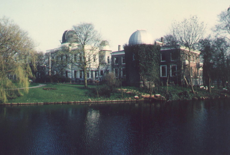
There are some telescopes left in the old building of the Leidse terrenwacht (see http://www.astr.ua.edu/keel/telescopes/leiden.html
and here is a picture:
And for a radiotelescope we have Westerbork/ Dwingeloo. Here a picture of the new antenna for Lofar and the old one from 1956.

-
As I mentioned a bit about 2 years ago in this thread: there are different forms of multilingual.
Most people think that the Latin alphabet extended with some language-dependents glyphs ( French : ^,', ` and German " ) make things multilingual.
But there are a lot of not-latin alphabets in the world (Thai, Hindi, arabic..) you have to cater for.
Then:
1. there is the interface that is USA-English now. Multi-lingual sites mostly have a choice (by way of activating national flag symbols f.i.) for the interface language
2. the cache descriptions. You could follow the same way: different language pages. The question remains: should cache description text itself be multilingual? Could one make a text in English with parts in Thai and Greek on the same page?
3. the logs. They could be in whatever language and alphabet. You cannot distribute logs to different sections according to language without getting in trouble with the timeline.
Further: the site is looked at by browsers. How multilingual can those be (for output (view)and input (text)?
At last: have you ever thought about how to do searches and 'alphabetic' ordering on multilingual (Unicode) texts?
-
Yes in Germany (my neighbour country) they have a lot of artesian wells. And build all kind of heath resorts around them believing in the healing properties of dihydroxyoxide, maybe this is so because of some residue of old german pagan beliefs. (or maybe it were the Romans )

And sure, once you have tracked for many days in terrible cold Himalayan mountains, a hot spring is something to remember for very long. (see my photograph a few posts back!)
I surely would want a subcategory for these.
-
Living in a land legendary for windmills (and dykes) (nearly living in a windmill museum) I would not want decorative windmills to be included.
That should be different category: garden decorations (together with gnomes etc.) or something.
But I should include a category 'have been windmills". We have here a lot around (round stone towers) without fanblades and being out of use.
-
I proposed a category: hot springs (artesian)
Clear cool drinking water is nice but hot bathing water is also very nice.

-
I have laying around some caches with English texts and maps, aireal photographs and all kind of extra info about the place.
All my caches are simple to find: go to the coordinates and find.
http://www.xs4all.nl/~atarist/geo/geohome.htm
for a list (with links)
-
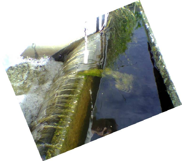
How about waterfalls? A lot of waterfalls are not on any map. This could really bring out the local "hidden treasures".
What does qualify as a Waterfall? What amount of water and what height difference?
I have a waterfall with cache here:
-
There are many places where water comes out of the ground.
But only (comparable) a few are producing hot water.
Hot in this context is: hotter then the surrounding soil, excluding frozen soil.
In many countries these places are made 'special' by people. There are temples, churches, baths, health resorts etc.
So there is always something interesting to photograph and to illustrate your story with.
-
Here's one yes vote, with a proviso - you are Waymarking a point in a country where pot cultivation is legal.
/In other words, a practical"no". Nice thought, but I'd just as soon call up the State Police and give them the info - or a State Park Manager, if it is in a park, that is.
I support this yes. Not everywhere in the world things are as in the USA.
In my country we have not much growing in the wild (we have not much wild here in the Netherlands :-) because of climate but we grow in glass warehouses (the same we grow our veggies in and our flowers).
In the interior of Marocco you will see many pot-fields between potholed roads. Those fields have the protection of the local police and are the only viable cashcrop for many poor villages.
Something else: on the Balkan there are poppy fields for the official production of medical opium derivatives. Totally legal.
-
[...]
As PDOPs pointed out the GPS 12 is still sold by Garmin. Not sure why. Its on the large and heavy side and they have so many better units now, but its a good, durable unit.
[...]
Garmins sells GPS12 because there are still people wanting to buy them.
They have many reasons.
One of the reasons is: they are scout-proof

-
-
There is something else going on with the 'alt' the GPS12 gives.
In my country we have a local 0-level (called NAP) that extends (within a few dm.) over mainland Europe.
The top of my head (hat realy with GPS antenna on it!) is 2 m above NAP.
The difference between my height and the theoretical surface of the WGS84 ellipsoid is 44 m.
What alt does my GPS12 give me? Not something of 44 m but about 2 m (+/- 20 m accuracy). So somewhere there is a table of geoidheight in use.
-
I have an old garmin 12 and wouldn't trade it for the world. I know my target will fall within a 50' diameter circle centered on where the unit sends me, assuming I'm using the same datum used to produce the target location.
ps I don't think they still sell the 12, but if they do I'd recommend it to anyone as a cheap yet highly effective unit. BTW .01 mi. = about 53' or about 18 paces.
Yes I love my good old Garmin GPS 12. Made beautifull accurate measurements (sub-meter) with it doing postprocessing of the GPS12 raw data.
see: http://www.xs4all.nl/~atarist/geo/gps_accuracy.htm
And last summer (when I asked) there where brandnew units for sale through the normal channels. So they are still in production. It must be a recordholder in this!
I have set the GPS12 so that he gives me on the display meters distance when using the GOTO. Walking along I see the number counting down en when it is zero: pronto!
-
I put a metal pin (okemo ski area) through the top of my orange knit hat (it is huntin' season ya know - or almost anyway) and stick the nilsson antenna magnet on that. My head isn't flat but it is big (oh god what did I jsut say).
Hmmm would a metal graduation hat (patent pending) work?
I have made myself some antenna's for GPS. See:
http://www.xs4all.nl/~atarist/geo/diy_gps_antenna_d.htm
Such a kind of hat-antenne I have already patented. See here:

-
When you are on land and working with paper maps then you will be very very happy to have a square grid on them. Measuring distances and the positions of things on the map is easy. So you use the local grid or the UTM grid.
Those grids are mostly metric but I have seen India maps with grids in surveyer feet. (not imperial feet).
-
From http://www.batterymart.com/battery_faq.php
"The practical difference between Lithium batteries and Lithium-ion (Li-ion) batteries is that most Lithium batteries are not rechargeable but Li-ion batteries are rechargeable."
So there are Lithium batteries (that are not Li-ion) that are rechargable. Garmin uses such a one.
At least that complies with the story I was told about the internal-battery-problem of the Garmin GPS12 series. As follows:
"the internal Li-battery will be recharged all the time there is a battery in the compartment. There is some controlling hardware for this inside. The problem is that this component sometimes needs a voltage higher than what NiMh can deliver to perform its function. There are some GPS12 series where even the voltage of alkaline batteries is not enough to start the recharge circuit. Then after about 2 years the internal battery runs out of juice. Garmin takes full responsibility of this manufacture error and replaces all GPSr's suffering from this fault. "
-
I use my GPS12 now for some years. I have no trouble with finding a spot within that mentioned .01 miles.
I have my local metric grid notation in use so my position is shown in meters. And the unit nicely counts down: 10, ... 5, 4, 3, 2, 1, 0 meters!

-
I think the better question than accuracy is the ability to get signals and keep a position fix. The sensitivity of the radio receiver and the quality of the signal processing is more important than type of antenna in a handheld. The most recent models such as the eXplorists with patch antennas have excellent reception. With the trend to smaller models, most future units will probably have patch antennas.
I do fully agree with this. In my opinion the helix <-> patch is for the most part an advertising gimmick.
When Garmin switches over from its own chipset to the SiRF III you will see a much better signal reception. Then the question of who is better: patch or helix is moot..
-
I love my good old Garmin GPS12. Sturdy like a brick. I hammered some nails in wood with it. And (I do not know your whereabouts, mine is The Netherlands, where Amsterdam is)) it is very good waterproof. I fished it out of a swamp many times. It fell of my motorized bicycle a few times.
New ones are still available (it is I think the longest selling GPSr model) but secondhand is OK and very low in price <100 $ so then your GPS12 can be overrun by a humvee and it is of no great financial loss. (The GPSr I mean)

Artesian Well
in Recruitment and Category Proposals Archive (Read-Only)
Posted
I still arrive at
Home > Waymark Directory