

Greymane
-
Posts
561 -
Joined
-
Last visited
Everything posted by Greymane
-
The information in the track should come from the 3D satellite data (provided you have enough fixes) and not from the internal barometer.
-
But you CAN'T load Mapopolis or Memory-Map Navigator maps into your 60CS! Sorry, didn't mean to imply you could. This is why I love my PDAs. With the GPSr, you are limited to just a few choices for maps and none seems to be a "best option" for caching.
-
I have a handful of units I use from time to time. I would suggest the Magellan SporTrak or the eTrex Yellow for a starting unit. If you would like a few more features, then check look into the next pricier models. The important thing is how it feels and handles to you.
-
Airman is correct. Since all topo maps are based on the USGS topo maps (which we all know are quite outdated), they are great for off-road navigation, but horrible for street navigation. Street maps, on the other hand, are great for road navigation, but generally stink once you leave the roadway. I find that a mix of software works best. I use Mapopolis for street navigation and Memory-Map Navigator for everything else (including marine charts). There are many choices out there. I suggest you check out several different packages and pick what you like the best.
-
I have a standard SporTrak. I use Memory-Map Navigator with it to send tracks and waypoints to the GPS. I also can plan my attack for the trip on my PC (with the desktop software). I can then print the maps out with my track and notes right on the map. The most economical way to go about it would be to get the Discoverer package for your state. You get the full set of USGS maps for your state and the software (PC and Pocket PC versions) for less than $100.
-
Sorry to get off topic for a minute, but I can't help it. I recently retired from the Navy and was a nuclear technician. Once, one of our guys thought it would be funny to wear a set of Anti-Cs (anti-contamination clothing . . . see above) in the nearby town around Halloween. It did NOT go over well (but certainly distracted a lot of people!). Personally, I always find smoke grenades to be good cover. As an alternative, you could have a member of your team streak across the parking lot.
-
You could always try hiding it here - might be tough to find..... This really isn't so bad. It is just out of the picture to the left. It is the camo one with the Geocaching stickers all over it.
-
I, too, use Memory-Map. I love it. I use it with topo maps and with aerial photos (which are awesome!). I use a Dell Axim with a CF card GPS. This gives me the SD slot for a memory card for the maps. Occasionally, I will use a Bluetooth GPS in place of the CF GPS. I have also used the Mitac Mio and the Navman PiN (really the same thing). They both work nicely. The built-in GPS is a nice touch. The only two concerns I have with these is the antenna does not open to a fully flat position and no replaceable battery. All PDAs are susceptabe to water and dirt, so I use an Aquapac waterproof bag to carry my PPC. These bags are great because you can use the PPC without opening the bag. You just use the stylus through the membrane.
-
Everyone has opinions about the different models and manufacturers. The best way to approach this is to find a store that sells different models AND has samples you can check out. Then, play around with the different models and see which fits you best. Functions vary very little between the manufacturers for a given class of GPSr. What really matters is how comfortable you are with the layout and menus. Just my two cents.
-
Certainly sounds like a solution to some of the parking problems people run into.
-
Not every Earthcache will appeal to every person. Just like micros don't appeal to some. There are many landmarks and tourist attractions that have a very limited appeal. Making a useful log entry will, of course, help the next visitors to make a more informed decision about whether or not to do this cache. You may find some Earthcaches very interesting.
-
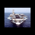
My avatar is the Mighty Ike (USS Dwight D. Eisenhower, CVN-69). It was my first ship in the Navy. I spent just over five years on this moving city. Four acres of sovereign U.S. territory anywhere you want it in the world!
-
Here is another place to find satellite tracking software. Satellite Tracking Software
-
Where do you draw the line? "I downloaded all the coordinates, so that is close enough. The rest is just running around and looking silly." I agree it is not found until you sign the log. As Criminal would agree, it ain't over until the paperwork is done!
-
yep...lure them in slow, tempt them with a treat, talk softly and slowly to them...and then BASH THEM OVER THE HEAD REPEATEDLY!!!!!! Isn't that kinda hard on the GPSr?
-
Very nice. I always like the handmade stuff best.
-
I have used new DVDs and I always give a certificate to the FTF. The prizes vary and I think anything would be appreciated. I, personally, think handmade things are very nice. I really love Muddler's idea, though. Just an added bonus for the FTF. Very creative, Muddler!
-
Just to play devil's advocate here... He was just doing his job. His attitude is irrelevant. You broke the law. You knew you were in close proximity to the border. (Hell, you had a GPS with you!) And you could have used more diligence to ensure you didn't cross. Regarding that friendly country to the North, I know a lot of Canadians and love most of them, but there are certainly plenty of people up there that wouldn't mind seeing the US sink into some abyss. The fact that the officer let you off with a warning should be seen as a blessing.
-
Need Some Help With A Magellan Sportrak
Greymane replied to brad87's topic in GPS technology and devices
Yes, it is common to enter coordinates in the wrong format. The most common format for geocaching is DD MM.MMM Some places show the DD.MM.SSS format. Instead of using seconds, we use decimal minutes. If you take the seconds portion and divide it by 60, you will get decimal minutes 15/60 = .25 43°20'15" = 43°20.250' -
I, too, have found suspended caches. The first I found was one of the most challenging I found to that point. The question is, if you have a suspended cache, should you have to post latitude, longitude AND elevation on the cache page?!?
-
Gas Prices Impacting Your Geocaching?
Greymane replied to AppaYipYip's topic in General geocaching topics
First, I just saw the price at the corner gas mart at $2.45 / gallon on the way into work. Second, anyone who has done extrication at a crash scene before will tell you (as a general rule), bigger is better. I will agree, however, that too many people who drive big vehicles don't know how to drive said vehicle. -
Well, Mr. Expert, I am questioning your qualifications (or at least your judgement in making that statement). A little black powder in a small package is not a highly dangerous thing. BUT, there are a lot of other compounds that in a package the size of a bison tube can do a WHOLE lot of damage! I don't pretend to know what qualifications you have or where you served, but I think you are sorely mistaken in this point. The average civilian bomb squad member does not have the career experience that many military EOD specialists get in a month. (Unless he/she has previous military experience.) (BTW, I do thank you sincerely for your service.)
-
Incredible video. Almost makes you feel bad for the little buggers. Almost!
-
When Can We Expect To Place New Locationless
Greymane replied to BONEGURU's topic in General geocaching topics
The answer is 42! The answer is ALWAYS 42! WHERE IS YOUR HEAD, MAN?!? (Oh, sorry, I see it was already taken by the OP.) -
How Many Other Otr Truckers Are Out Here?
Greymane replied to TwoTruckers's topic in General geocaching topics
I am ashamed to say I never thought about trucker friendly caches. My family runs a trucking business in PA. There is a Petro near my home. I will see about placing a cache in / near there. Thanks for the idea and keep up the good work. I know how hard that work can be. (Although, I always enjoyed riding along as a kid.)