

geojibby
-
Posts
331 -
Joined
-
Last visited
Posts posted by geojibby
-
-
Field notes is one of the coolest features of paperless caching. I remember having to manually type out zillions of geocache codes from the calendar day on my trusty 60Cx when logging. Now you just upload the notes and viola, log from there! Super rad feature!

-
I publicly mocked the wireless transfer option in Garmin's GPSrs when it first became available, but later recanted when the chirp device came out. But with this one, I really can't see any good coming from it.

Here's more info: Link
-
Why would Garmin invent such a device? I don't get it. Every 2 year old kid these days has a smart phone, you wouldn't track your kid with this. I can't fathom the need for this product. I could see a cool geocache idea, tying this thing to a goat in a heard and strapping a micro cache to its collar, but that's it.

-
Haahhaahah!! I hadn't seen that part - I assumed it was sat coverage! I guess this is so you don't lose your dog....
 I just saw that this new gadget from Garmin is available for pre-order from GPSCITY. It might be the answer/competition to DeLormes/Spot combo.
Not Hardly!!!
Might as well use a cell phone, most places I want to go a cell doesn't work.
-
I just saw that this new gadget from Garmin is available for pre-order from GPSCITY. It might be the answer/competition to DeLormes/Spot combo.
-
Ya, if you are navigating to a geocache, select the geocaching-active dashboard and you are good to go. It's very confusing aspect of the Dakota if you select the geocaching - nearest instead.
Am I interpreting your video and answer correctly? If I call up the waypoint and then use the geocaching active selection from the compass screen, I should see the correct waypoint/cache name on my screen instead of a random nearby cache?
-
I've found just copying the caches to the internal memory is easiest. It takes up virtually no room (on a universal scale). With the limit cap, there's virtually no advantage to putting the .GPX file on the memory card vs. the internal memory.

Thank you Geekboy.....
Last night when Groundspeak was down I was going through the garmin forums and saw one reference to the file structure of the SD card needing to match the one on the Garmin.
SO SIMPLE! Why on earth was that simple little bit of information no put in the instructions ...just stating that when you do copy files over to the SD card that they need to be in the same file structure as those on the Garmin.
Everyone kept telling me to just "put them on there" and it will work... NOT!
It took about a minute last night after I read this to get the garmin reading files off of the SD card.
Thanks again for your reply!!
-
Check this out:
I still have a lot to learn about my Dakota 20. One of those things is how to use waypoints.
When doing a multi and getting new coordinates, I know to enter "next stage". But why does it say I'm navigating to a different cache (it seems it usually tries to get me to the "next nearest" cache), not telling me it's going to the waypoint? I find this very confusing, as I'm never sure if it's really pointing me to that other cache or actually directing me to the waypoint, just with the wrong name showing on the legend.
Here's an example, though this is for a puzzle cache, not a multi, and I made the actual coordinates a waypoint rather than a "next stage".
I just turned on my Dakota 20 and selected "Where To?". I selected the waypoint I want to go to. It showed me the map, and it looked as though it was finding the correct location. (I renamed the waypoint as (name of cache)-Actual, and that's what the map showed.) But when I hit GO, the name of a totally different cache showed up and my waypoint no longer shows on the screen. I know that the cache that's named at the top of the screen is some distance away from where I want to go. Which one is it actually directing me to? If it's the other cache, what am I doing wrong? <img src="http://forums.Groundspeak.com/GC/public/style_emoticons/<#EMO_DIR#>/signalskeptical.gif" style="vertical-align:middle" emoid="
" border="0" alt="signalskeptical.gif" /> -
I'm running the 4GB card. I tried cutting up the ibycus canada topo into multiple maps (a couple of provinces per map) and experienced slower performance with them all loaded on the card. I went back to one western canada chunk and ND and it is quicker. FWIW.
-
GPSCITY is awesome! I've dealt with gpscity.ca twice now and everything is fantastic. I had my sister in law nab me a couple of items from the Calgary store too. They are a great company to deal with.
-
The one file .GPX pocket query is the way to go!

Well, this is interesting to learn! I was a Basic member until just a couple of weeks ago, so yes, most of my caches were added by the "send to GPS" option. I didn't realize that the ones sent by PQ were collected into just one .gpx file. That will indeed make it easier in the future.
-
The cardinal difference is size/resolution and then a few lesser capabilities that the Oregon can do over the Dakota.
The topo map thing isn't a selling point (for me anyways) because of gpsfiledepot and other available free topo maps to favor the Dakota.
I did buy the Dakota 20 over the Oregon, but my black friday price differences were $179.99 vs. $229.
If I was you and cash was no object, I'd get the Oregon.
GPSCity has the 450 on sale right now for $240 and Cablea's has the Dakota 20 Bundle on sale for $230 (includes Topo). Since the price is basically the same for both, any suggestions which way I should go? Any help would be great!!!!
-
We just hashed this out in a Dakota thread. It's the same answer for the Oregon. Delete all your PQs from the unit after you've found lots. Then re-run the queries and copy them on fresh. No need for GSAK. No need for jibba-jabba. Go caching, find lots, upload your field notes/logs, re-run your PQs, delete the old ones on your GPS, copy the new PQs on. It's a 30 second operation. It's easy, fine and dandy like sour candy if you start fresh.
-
If I understand you correctly, you are trying to clear out your found cache list. From this thread we learned that the Dakota "flags" found caches from a .GPX file into its memory. So, logic should dictate that if you clear out all of your .GPX files from the unit and delete the visited.txt file, all the "found cache" flags should be removed also. Then, just re-run your PQ and copy that/those file/files over. I've found it just as easy to delete everything and start fresh with caches you haven't found. Plus, copying .GPX files to the unit take only a few seconds, no big deal.
From your previous note it seems like you've got lots and lots of .GPX files on there, probably from the "Send to GPS" option. If you do the pocket query method, then you've just got one .GPX file to worry about and it will be easier to keep your found cache list cleaned out.
If I delete the .gpx files completely, won't I have to reload all those caches again, even the ones I haven't found? I don't mind deleting the *_visited.txt file now, since I've confirmed that I do have the codes for a few puzzle caches I've yet to get to the final on. I'd saved them as field notes, just in case I lost the paper I'd recorded them on (which I had, temporarily).
-
Delete all your .gpx files and delete the visited.txt file completely. If you are using a Mac, make sure you empty your trash before disconnecting your GPS to make sure all the stuff you deleted is really gone.
 I read this thread and am still at a loss. I deleted a few dozen .gpx files (one by one...what a drag!) and discovered when I turned on my Dakota that they still showed up in my Found list. I found this thread and tried 1) downloading a new .gpx file and 2) deleting files from the *_visited.txt file (I didn't delete the entire file, though). My original Found list is still showing. Do I need to do 2) before 1)? Do I need to delete the *_visited.txt file completely?
 -
Shot in the dark - but is your Nuvi's waypoints full??? Did you try deleting all the previously installed stuff?
-
Having read the link above and getting used to my new Dakota 20, I still don't get it. It's odd that you can't delete a cache. But on the other hand, it's not that big a deal either.
-
probably the one that runs on the iPhone. hhhehehhee... just kidding!
-
This is a good point. Best I've ever done in one day of caching is around 30 or so as well. But it's nice if you're going on a family vacation to a new area for a few days to have tons of caches available just in case the opportunity to go caching arises where you're at. 2000 is probably enough to cover bases, but it depends on what you want.
Why is there a need for more than 2000 caches? I've been using a Legend Cx (and just got my new Dakota 20) that stored 500 caches. At best I found 30 or so before doing a new pocket query. And if I need more, I put them on GSAK and download when I get to a new location.
-
I'm not sure the GS app can do the offline thing. I bought iGeocacher for my iPod Touch and it worked like a portable database of caches. It uses wireless to transfer .GPX from your computer to the app. It might work for iPad but I don't know if iTouch apps work on iPad. If it did, it might be an option for you.
-
I don't get why Garmin limits the number of caches on a GPS unit and then starts their own "open" caching website. hehehhe...... Close one door and open another!
-
Cool! Yes it does. I just checked it out. That's the way to do it! It's a lot more straightforward than the method I proposed before - I'm still thinking the 60Cx way. hehehe...

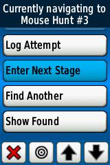
Does the Dakota have the “Enter Next Stage” option like the Oregon?
-
No probs. I've got the Dakota 20 too. So, goto "mark waypoint", save and edit (pop in your new puzzle coordinates, when done "x" out of the menu. Then click the "where to" button, select "waypoints", find your updated puzzle coordinate waypoint you just entered, click "go" then "x" out of that menu, click "compass" button and simply make sure you have the compass info field selected for distance to destination.
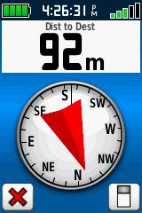
EDIT: I think you have the incorrect compass dashboard selected. You've got the "geocaching-nearest" selected. So, on your compass page, just click the button on the lower right and from that next menu, large data field (or small data fields) and you will have the screen shot I attached above.
-
Guess who's living in a Siberian Gulag now....


Paperless Geocaching with a Garmin Dakota 20
in GPS technology and devices
Posted
Log in, goto your profile by clicking your name on the top right corner. Scroll down until you see "Field Notes" on the right hand side. If you have successfully uploaded them, they will be there waiting for you to log your finds.