


reef mapper
-
Posts
70 -
Joined
-
Last visited
Posts posted by reef mapper
-
-
So your saying that you have aerial imagery to the 60CSX? You mean have it loaded and working? I gotta see this one... Link please?
OK - check the earlier reply for a link.
-
You've said you can do it, but can't be bothered to throw it on Photobucket for free to actually show it? How can anyone "acknowledge" it if you're not actually presenting the evidence?
Actually I was meaning having the track on the airphoto on the Garmin, not in GE on computer:
http://www.flickr.com/photos/10187454@N00/3159078789/
So it can indeed be done but of course the unit wasn't designed for this so results aren't as good as those now have with a PN-20. But until getting to use the PN this was my only and very welcome option to aid field work.
-
If anybody can demonstrate the capability of their 60CSx with their position superimposed over Aerial Imagery (as opposed to maps of unverified accuracy), I'd be pleased to acknowledge such.

I added a screenshot of a track faithfully following a coast road on an aerial image on a 60Csx but its on the 60Csx group unfortunately, so a link won't work.
-
One time-saving option is to use a Blue Logger, with an elevated E antenna if necessary, with single-difference post-processing with GPSPostPro against free data from a nearby CORS site. Maybe not if one is only mapping one or two trails but for regular mapping it very efficient.
-
Xmap Editor will import SHP files, e.g. I just did a Barbados road map, import main roads, set width and red colour, import secondary roads, colour yellow, import the island polygon, give it a beige fill, export as a map file to the PN. Took a few minutes.
I've also been making aerials and vector maps for a 60Csx. This is just so much easier. Xmap Editor also imports MrSID and Geotiff.
-
Something I use when logging waypoints for mapping, if I want to record some attributes I can assign number or letter codes, enter them in the comment field between commas, then when downloading waypoints I can produce an Excel spreadsheet with columns generated by the CSV.
-
BTW it also displays water temp which could help in deciding what to wear before you dive in

-
Hi -
Recently I dunked my trusty Foretrex 201 in the lake (yes... it was velcroed to my wrist...).
I purchased a 60CSX and I have been using it for caching for a few days now.
I was wondering what your favorite feature of the 60CSX was so that I might discover it if I haven't already.
Thanks!
Logging water depth from a sonar.
-
The 60Csx screen is indeed a bit bigger than the PNs, but an aerial photo or sat image on the PN looks better than it does on the Garmin. I use both of those units and upload my own maps and images to both.
The only thing you can see on the Garmin screen is a topo or street map. It doesn't accept sat or aerial photos so there's no way to compare this to the PNs. The maps on the 60CSx are pretty readable but on the border of being too small to be very useful. If you shrink the screen about 20%, you've got the screen size of the PNs. I believe that would be too small for me to find very useful. It's too bad, because the whole Delorme package looks great, but the screen size is absurdly small.
Right - it isn't a direct comparison because one is designed for rasters and the other isn't. That doesn't mean I don't routinely use 60cm Digital Globe, 1m pan-sharpened Ikonos and airphotos on the Garmin. Of course a bigger screen would be great but the PN with high res images is an absolute boon in my field work.
-
Alan :
Can the images on the Garmin be georeferenced?
Norm
Absolutely. I put a couple of screen shots on the Yahoo 60Csx group with an aerial plus a track I recorded on it along a coast road to check the georeferencing. It is a 30cm resolution colour aerial of reefs I am working on. Redraw isn't up to vehicle speeds but like the PN-20 I use them for either kayaking or walking on mapping projects.
I tried to add a link to the shot on Flikr
-
The 60Csx screen is indeed a bit bigger than the PNs, but an aerial photo or sat image on the PN looks better than it does on the Garmin. I use both of those units and upload my own maps and images to both.
-
A point about Garmin output from this line of units vs other brands, when downloading, the data are as usual in WGS84, but live data are in the datum set by the user. Very useful for those of us using local Astro datums a lot of the time but not something that jumps out of the manual at you.
-
The high does follow the pull of the moon, but it isn't simple. There is a lag, so highs occur later than max pull from the moon, plus as the water sloshes back and forth some places have two unequal highs in a day, some have one. So tide tables for a specific site are best, as noted.
-
Probably won't help but did you try it on USB power?
-
I do enjoy helping people out and do a lot on another mapping forum. But it is always good to see at least a mention of having tried a manual or done a search of past posts for example.
Anyway if you had spent over 2 hours trying find why as computer admin Delorme's Xmap won't load because it needed admin privileges then you would be grumpy too.
Well that's my feeble excuse.
-
You guys are more generous than most, faced with a request that says " my time is too important to me to read manuals so I'll ask you to do that for me" , followed by " I'd like you then to take some more time explaining what you learned. I'm really too precious to do it myself and I'm not too ashamed to say so".
-
I have a 60csx that won't power up using batteries. It will power on if I hook it up to my computer using the USB cable.
Anyone else had this problem?
Kenai
A quick tweak of the battery connectors to make sure of a good contact has fixed similar problems with this unit.
-
Within the last 10 days I read a detailed description of replacing a screen with your own piece of lexan - it may have been on a Vista but the approach would be the same as I realised as a 60Csx owner myself when I read it . If not here then on a Garmin forum. Google it - it was done for around $20.
I should add that it was step-by-step from buying the plastic, making a template, cutting the face and installing it.
-
Its usual to have a waypoint in Kansas, and Taiwan, with a new unit, and option 3 above is the usual response. Are you saying that the Kansas waypoint wasn't there before when you were using the unit and only appeared from nowhere after the battery change?
-
Thanks for that Chip. Actually that second group isn't only about free material to download. Outside the US that can be very limited. There are no free downloads finer than Landsat for this region and much of the rest of the world. Working on a management plan for a management area in Trinidad involved purchasing Ikonos imagery which I have processed for the 60Csx. The high-res airphotos I use for reef and mangrove mapping come from Govt and are normally very expensive. For a UN forest mapping project I needed the best detail possible in the field so I was trekking around with my Thinkpad with 0.6m Digital Globe images and live tracking. Now THAT would have been easier if I could have had the images on a GPSr!
Cheers.
-
Thanks for that. It took me many weeks of searching to find out what I needed to know to set this up. A few people have contacted me after I posted about it on the 60Csx forum. Before that I couldn't find any posts or methods for doing this. I bought a $600 data logger from New Zealand before I realised I could log directly from the sonar to a Garmin costing around half that.
Still have no idea what NMEA options there are with the PN-40, but in any case I won't be giving up the 60 any time soon.
-
I have a real problem with the short-sighted/clueless restrictions that are placed on GPSrs. If a unit can display calibrated rasters, why can't I load them? Why do I have to be limited to accessing only those images provided for the US and by the GPSr manufacturer? Can you spell Global? Take a look at the baseline map in a Garmin for e.g. the Caribbean - for which nothing better is available from them. Can you say "kiddies play sketch?"
Is it a fear that masses will start producing their own maps and deprive Garmin/Delorme et al of millions in topo sales? What a crock. Have you tried making your own maps or making rasters for a Garmin 60Csx? I do it because there is no other source and I can tell you there won't be multitudes of people getting into it to save costs if there are maps available. I would bet that the number of people engaged in making Garmin-compatible maps is a fraction of 0.1% of the number of Garmin owners. Why alienate the serious users? They really aren't a threat to profits!
Meanwhile, thanks to the reverse engineers, I'll be loading an aerial photo to my 60Csx for work tomorrow.
Manufacturers - wake up!
-
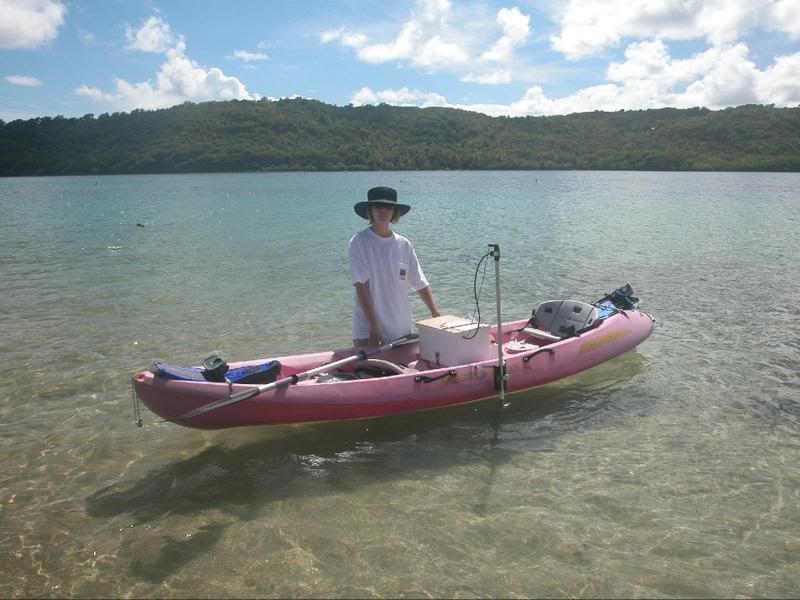
We are indeed sonar-equipped!
The hat was a sore point. Her mom told her to take it, she didn't like it but wore it anyway, I thought it looked cool and needed a caption like "What's that you said?"
For anyone interested that is an active sonar, 7 degree beam angle and logs depths from 40cm to 100m. It means I can get in to shallow places that would impossible with any other type of boat. There is a small 12v sealed lead acid battery in the box.
-
On the 60Csx you can set to display water depth and temperature. You just need the NMEA input to provide the info. If I've got this right, it shows my setup of assistant, GPS and sonar on the kayak. Antenna is on the top of the pole, sonar at the bottom, feeding into a data logger or the 60Csx:
It took quite a while to work it all out but what a system! It logs depth with tracks so I can download to my mapping program (Map Maker Pro) and produce depth profiles, or with enough points a 3D view of the sea floor. The temperature is displayed but not saved.
Thanks for checking the Datums. Naparima is the only one from this region in the Garmin list as well. About the other examples, with over 1000 Datums in existence it isn't surprising that something in use for only one small island in the Caribbean doesn't get included. Actually it is often better to have the user-defined option, because the transform parameters from/to WGS84 are just estimates and vary with who did them and on which part of the island. Now if only the earth was flat we wouldn't have this confusion.

Garmin 60Cx, where are the "Tide Tables"
in GPS technology and devices
Posted
Mine are under Find - Marine - Tide Station on the Csx.
Can't remember how to add a screen shot here.