


Chipper3
-
Posts
168 -
Joined
-
Last visited
Everything posted by Chipper3
-
The posted coordinates for a cache must be changed as the landmark that was a reference point for the cacher taking a bearing and a distance has been removed. The distance moved was about 25 feet from the original location and the Final location has not changed. I used the Post Log entry to change the coordinates per the pop up message on the cache page in edit mode. The changes show up in the log but the posted coordinates remain the old coordinates. I am concerned that someone trying to find the cache will never check the log posting. Or will an admin get flagged by the log post and make the change? I can understand why an admin would need to check for cache collisions, etc. The cache in question is https://coord.info/GC8J4XA
-
Yes, no precautions create fail-safe conditions for careless cachers. I have placed the boxes outdoors in duplicates of my cache technique. And we have had very wet spring in my area. I open the boxes every 3rd day pull out the log and go thru the motions and replace. Folks, I am not suggesting that dessicant will fix open baggies or a poorly constructed caches. I am just gaining the edge for sealed containers being able to go the extra distance. I keep data and will post a graph of the results.
-
I have placed the boxes outdoors in duplicates of my cache technique. And we have had very wet spring in my area. I open the boxes every 3rd day pull out the log and replace. Folks, I am not suggesting that dessicant will fix open baggies or a poorly constructed caches. I am just gaining the edge for sealed containers being able to go the extra distance.
-
Hmmmm.... My test boxes are steady at 5% moisture and return to 5% moisture after closing back-up. After one month, the packets indicate fully absorbed and doing no more good. (Replacing packets as part of cache maintenece is part of my planned activity. ) But in the mean-time, the associated journal in the box stays dry and the one in the other box is "damp." So I kinda' think that the presence of packets has some positive effect. It may be that I see these results as I am using the 350 ml 3X5 inch boxes so the volume to protect is small.
-
OK, I realize that this is kinda' geeky and may not work for everyone but I am enjoying a solution to the problem of wet and soggy logs in my caches. First of all I use a good "house" or shelter that will hold a LocknLock box for my contents including the log. I found that even with time a LocknLock box will not prevent logbooks from becoming moist. No direct rain , etc. but humidity is humidity and nature abhors a vacuum. So I obtained desiccant packages from Dry&Dry and use the ones that have a moisture indicator and place in the container. I have two containers being monitored. I placed a temp/moisture measuring device in both. In one I place two desiccant packages and locked the tabs. One container shows 60% humidity right now which matches the third meter that is outside the container. (ambient.) That the closed container reads the same as the ambient tells the story that even a LocknLock will slowly gain moisture. The second container (with the desiccant) always reads 5%. At some point, I am sure that when the desiccant absorbs all the moisture that it can hold then the humidity will go up in the container. I have found that before I added the meter that the indicating dessicant would show high humidity after about a month. I'll use that info to time my maintenance runs on the caches to replace dessicant packages.
-
I checked Garmin Support. 1.) Their advice is that your device would not just "drift" or change the display from four decimal places to two decimal places. 2.) if you were actually sitting on N 42 32.9900, the device would not display N 42 32.99. 3.) if there i something wonky in your device, you will NOT be able to correct by selecting Position Format. The suggestion is to reload a current version of the software by connecting your device to a computer that is running the Garmin Express program and reinstalling the software. 4.) If that does not correct the issue, then you have a "weird-a-rama" hardware problem and need to contact Garmin support. It would be very helpful if you could take a picture of your MAP screen showing the two decimal format.
-
Additional thought.... Now , if indeed you are not seeing a rounding phenomena, then the difference in N 42 32.999 w 079 34. 555 VS. n 42 32.99 w 079 34.55 is 59 feet. Again, I could not find a setting that only shows 2 or three decimal places. The default is 4 decimal places and you need all 4 to be accurate. PS, What are you doing slogging around in the middle of Lake Erie near the Canadian line? =)HaHa!
-
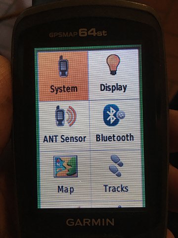
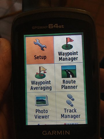
I have the Garmin Map64ST Your menu will be the same. I am not sure why you show N 42 32.999 w 079 34. 555 or n 42 32.99 w 079 34.55, I suspect that maybe if you are dead on set of coordinates, the device will not show the unneeded extra decimal places. I do not think there is any option in the set-up for that TYPE OF FORMAT but N 34 35.5909 (using my coords) The datum should be WGS 84 and that is the option that you should select. The Datum selection is not going to alter the Position formating. I agree that the Garmin menu selection navigation is kinda' clunky. 1. Use the PAGE button and keep pressing until you see MAP option and stop pressing button and you will see A screen populated with your coords. (IMG_7899) 2. Press MENU button twice and you will see a screen like this with SYSTEM highlighted (IMG_7898) 3. Press the ENTER button and you will see this screen with SETUP highlighted (IMG_7897) 4. Scroll Using the arrow keys down & over and Highlite the POSITION FORMAT icon which will look like this (IMG_7896) 5. Press ENTER button and you will see this screen displaying your current selections. (IMG_7900) You can use the arrow scroll keys to select POSITION FORMAT or MAP DATUM. You press ENTER to alter the settings on the resulting screen. You want hdd mm.mmmm for POSITION FORMAT and WGS 84 for MAP DATUM. The MAP SPHEROID is auto selected when you select the MAP DATUM. (IMG _7901 & IMG_7902) I hope this helps....


-
How do i protect my TB from going missing?
Chipper3 replied to BabyYodaGeocaches's topic in Trackables
I see you haven't released your bug. Go for it or it want go anywhere. =) -
I have a cache that utilizes a website and a mystery theme to obtain coords, etc. The site gets lots of geocache traffic. So I guess plenty of folks think it is safe. However, I don't interact with sites that do not show the padlock icon in the url bar. The padlock indicates that the site uses encrypted data and you will usually see on ecommerce and banking sites. Still, a questionable site could also show the padlock. But having a secure site costs the site owner money to offer that level of protection. The fact that the owner has posted the url on the geocaching site AND has paid precious $ to obtain the secure site encryption "padlock" is good enough to make me think that visiting the site is not too risky, and of course, download nothing. If you want to know more about the security on the site, then click on the padlock to gain some insight. You can turn off acceptance of cookies in your browser before visiting a site for the first time.as another level of protection. Since you posted on this site, you must have had a level of trust. Go ahead and click that locked padlock icon and then you can see the security certificate as well as the cookies that are set because you visited. By viewing the cookies that are set, you can also make some decisions about the real purpose of the site. Also visit this url published by Chrome to learn more about gaining knowledge about a site's safety. https://support.google.com/chrome/answer/95617?visit_id=637478363619220888-2985360332&p=ui_security_indicator&rd=1 You could also copy the url and paste into the dialog box at this site to obtain possible nefarious content such as malware. https://transparencyreport.google.com/safe-browsing/search?url= And despite what precautions you may take, crooks will still find a way to get in your house. Just do an appropriate level of due-diligence.
-
In addition , for OP, EDEXTER... (Continuing previous post) You mention that you live in Massachusetts. So navigate to this link- https://massgis.maps.arcgis.com/apps/OnePane/basicviewer/index.html?appid=47689963e7bb4007961676ad9fc56ae9 From there, follow the pretty simple directions. I just picked an interesting spot on a spit of land along the Connecticut River in Franklin County. I clicked in the red outlined area near the indicated swamp and the owner info pops up. Please see screen shot of that activity. More info can be found but each GIS site is a little different. On this site you can also search by address, so type yours in and find out about yourself. =) For full directions on the MASS GIS site, link to https://www.mass.gov/service-details/massachusetts-interactive-property-map

-
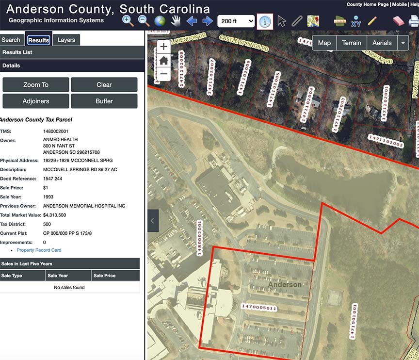
Just about every community now uses some form of online GIS or Tax Map or Property Viewer to describe property, who owns it, etc. A LOT of useful info can be found and property owner is one and what you are looking for. For example, for Anderson County, South Carolina the property viewer can be found at this link: https://propertyviewer.andersoncountysc.org/ For this example, just check the Disclaimer Box and click in Open Site. you will land on a large map but by zooming and scrolling, you will be able to focus on a particular plot and surrounding area. Click on the property and you will get a window with all kinds of information on the property. For example, I want to place a cache around the lake that is also used as a public access walking trail. After zooming in, I locate the lake and the property boundaries will be outlined, Click on the property and a pop-up will disclose who owns the property. Check out the attached screen shot. I find just about every entity has a similar web site.
-
I am also on a MAC. I just pull up a browse map. Select any layer type. From the Browser ( I use Chrome) Menu Bar I select Print. Then you will see a printer dialog for your printer. There are options on some printers when printing a web page. Like, printing background content for example can be toggled on/off and that can affect what is actually printed.
-
My Travel Bug is missing how mark not in cache.
Chipper3 replied to Chipper3's topic in How do I...?
I have lost every TB that I have put out. Sometime they go a few miles and then poof! I even tried the TB "Hotels." I think that, at the end of the day, people just don't pay much attention and/or don't know the "soul" of the activity. Maybe the equivalent of Trolls who just misbehave for the entertainment value. End of Rant -
My Travel Bug is missing how mark not in cache.
Chipper3 replied to Chipper3's topic in How do I...?
Yes, I am sure that Rosey Pinecone is now part of a collection somewhere. And she had such a great mission! =( I will try again with a new Bug
-
My Travel Bug is missing how mark not in cache.
Chipper3 replied to Chipper3's topic in How do I...?
Thank you, Just what I needed. I was failing to find the "accept" button. -
I have a travel bug that still shows in a cache but it is looooong gone with no logging by whoever took it. It has been several months. How to I mark the TB as missing. How mark so it no longer shows as being present in the cache. dan
-
Thank you, Unit473L for a solution! Worked perfectly and a good idea to refresh the data every now and then to be sure of having up to date info.
-
I changed the wording of the hint on a cache from my desktop. When I view the cache on my laptop, the change is updated. But, when I check on my mobile app, the old hint is still showing. Maybe memory/cache not updating on my iPhone? Or does it take a while to ripple/propagate thru the net? The change was made 24 hour ago . Thoughts? Suggestions?
-
cerberus - You are correct and that was part of my confusion as the two numbers are called different things on different parts of the site. Regardless or the name, I am memorizing that if it begins with TB then that references the page describing the trackable. The other number is used to actually do something with the trackable. It is the "secret" ID that is revealed only when someone is in physical possession of the trackable in order to change its "state" by physically doing something with it. And is name is Trackable Code.
-
Thank you Max and 99. The info and references are very helpful to me. From the Help center- " There are two codes for each trackable. Reference number This is a unique reference number which starts with TBXXXX. It is visible for everyone who visits the trackable details page. Use it to log a note to the trackable. Tracking code This code is on the trackable item. It is meant to be seen only by people who have the trackable in their hands. Use this code to post “Retrieve”, “Drop”, “Discover”, “Visit”, or “Grab” logs. Please do not show this code in your uploaded photos or logs.
-
There are two numbers that are associated with a travel bug when I view on of my travel bug pages. There is a number in the top right corner of page that seems to be how to be a reference #. Starts with TB There is a second number that is called tracking number and one of mine starts with 2P What is the difference in these two numbers and when should they be used. One example is that a log asks for a tracking code. Which number is to be used?
-
I bumped into the facebook trackables page and am confused. Why do people publish their trackable WITH the log code?
-
Number of new caches decreasing?
Chipper3 replied to brendan714's topic in General geocaching topics
@brenden This is an interesting topic and one with n+1 interpretations and conclusions. I'll add mine. Only using your original data, technically not enough data points to make strong statistical "bets." (inferences) but if I can be given some license, All but two years behave predictably and "normally." From an observers point of view , there are two years that seem to be outliers (the probability of occurrence is not explained by the variation in the data for the other years) and cause for examination to find out what special causes influenced the data. Everyone wants to focus on why the 217 normalized data point was lower than expected but equal weight must be given to the 2015 data point that was higher than expected. A G A I N not enough data to make statistical bets with high confidence. But 2015 and 2017 are so far out of line to deserve examination higher than expected as well as lower. -
Switching from Mystery to Multi-Cache in Design
Chipper3 posted a topic in General geocaching topics
I have a 7 stage cache under construction and originally thought it should be Mystery. Based on advice I received in the forums I am considering switching type to Multi. When I changed type in the edit mode to Multi, I received a message that if I switch type, I will lose all the stage information. Ouch! I am afraid to change the type just to see what happens. I do have all the info for the stages but would hate to type all that back in, etc. What has been your experience?
.png)
.png)


