


68-eldo
-
Posts
355 -
Joined
-
Last visited
Posts posted by 68-eldo
-
-
It would be my guess they would set a new reference mark (RM3) instead of resetting RM1. RM3 would be in a totally different position to avoid confusion.
-
Wow is right. Excellent report, really great field work Papa Bear.
68-ELDO
-
Ah – I had not thought of a direct reading on the mark. I did think of using a device similar to a knife blade but I figured that function would be built into the rod.
-
I certainly am not an expert on this, but I imagine the surveyors rod has a metal projection at the bottom that fits into the line that goes through the center of the benchmark.
I believe the line in the center is the point measured to in the survey.
-
Is it my imagination or is that concrete pillar just wired to the railing? How stable would that be?
-
Thanks for all the replys so far. I borrowed my friends metal detector and the markings say Bounty Hunter Pioneer EX. He's trying to find the owners manual but it seems easy to operate. It has 3 depths settings Shallow,Medium, and Deep of course I am not sure what kind of depth they correspond to. The top section has 4 Probable Target options Iron/AL ZN/AL 5 cents/COINS. It will probe for all or you can reject the ones that you want to. I am not sure if I should leave it in the find all mode or reject a few of them. It also says it needs to stay in motion to detect objects. This one seems to make the same noise regardless of how big the object is. Now all I need is some dry weather and some luck to find this benchmark.
Does the manual look like this?
-
The PDF docs worked for me. Very interesting.
-
From Wikipedia
In the fields of chronology and periodization, an epoch means an instant in time chosen as the origin of a particular era.I think in computer terms it can mean from the time of installation of the program. But that does not seem to be the case here. You would have to ask NGS what it means.
-
Destroyed on GC. Note to Deb suggesting 'destroyed status', and go with her decision.
My example is: KV1383. GC lists last find in 1973. I was going by the GC list. NGS reported it destroyed in 2005. Deb said that I could take it home if I wanted.
 It is not in the proper position. It is of no use to anyone. It is destroyed.
So did you take it home and plant it in your front yard? I would.
-
OK, I got it. Under the Geographic web turn on Panoramio layer. You can only see it when at the right altitude. If you zoom in to close the blue square disappears.
Nice picture Paul.
-
In the center of the "target" box is a blue square. Hover over it to see the title, "Waterfront". Click it to see a ground view. You will be looking along the abutment of the original Intercoastal Waterway bridge. And you KNOW what you often find mounted in an abutment. :-)
-Paul-
PFF, what things in the layers panel do you have turned on?
I only have terrain and roads turned on, so I do not see the little blue square. Street view comes close but I don’t see a benchmark on either side of the road.
-
Thanks for bringing this up this is a topic I was thinking of bringing it up.
I was looking at the laser(?) measuring tapes in Sears and noticed they were good for only about 50 feet. Then I noticed one that sold for over $200 that had a greater range (about 1000 ft. IIRC).
Then a guy showed me a pin from a golf course. It had corner reflectors on the top. Now I thought that the rangefinders for golfers was based on the height of the pin. But with corner reflectors that implies the golfers are using laser rangefinders. I don’t expect them to be very accurate but it would be interesting to look into.
-
Have you considered having this report published somewhere? I think it would be a great write up for a surveyor’s magazine.
-
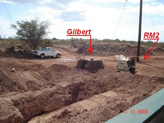
Correction it was Saturday, not Sunday. I was not able to stop. But it looks like they are doing a far job of protecting it. But it looks like the concrete culvert with the chiseled square is gone. I believe all the development in the area is based on surveys from this mark. So I think the construction people will be careful of the mark. RM2 was also visible. I did not find RM1 and the area where it should be has been at least trampled to bare ground. Maybe I can get out there again and look for it.
-
So on Saturday I happen to go by Gilbert and there is a lot of construction in the area. Hope it survives.
Glen
Edited to correct day
-
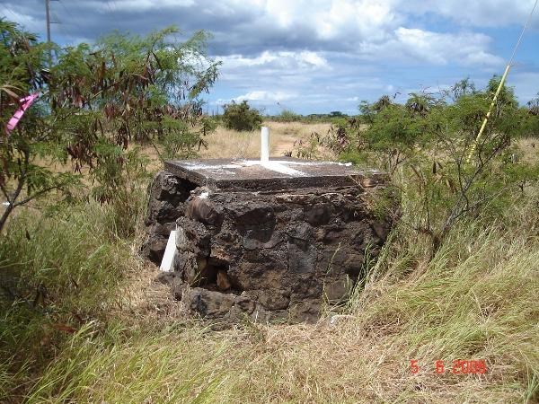
So the most I've seen surveyors with when I've run into them (never occupying a station I've been looking for, mind you; on construction sites or doing land surveying or whatnot) are tripods standing four or five feet. Well, recently I came across the most complete of the Hawaii Territorial stations that I've yet seen, KALAEPOHAKU RESET (TU1291). (This time I actually saw the disk under the iron pole!) So here's the issue:
Could a surveyor actually use this station today? They'd have to remove the top part of the iron pipe in order to access the station disk from above - that little divot you see in the center goes down to the disk, but you can't position an instrument over it. Is it feasible to get an instrument over such a mark, centering it on the disk through the pole? Or would they just go for a different mark somewhere else?
On the other hand, at least the mark is a bit more useful than WYLLIE 1927 (TU1263):

Station Gilbert. (TU0625) The signal is missing but was there as late as 2001.
Station Gilbert occupied.
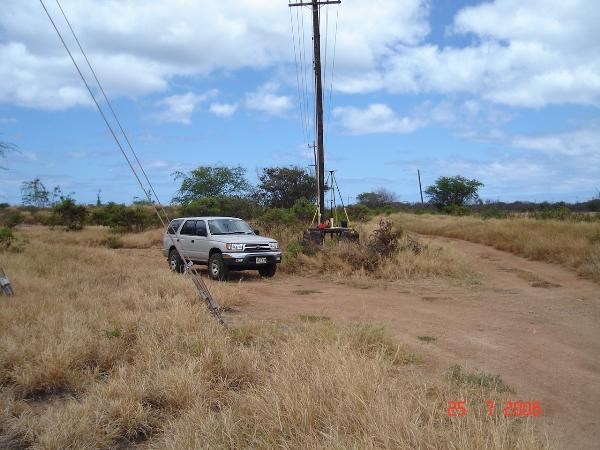
Can they do that under the power lines?
Gilbert is the original construction. The platform on the top is there to support the tripod.
The platform for TU1291 has been rebuilt.
-
Or if you get the data sheet by station name you also get only the D code. I would submit the description and see what happens. At least they will have the description and then someone else could provide the geodetic control. I imagine its possible (maybe through special request) to see the information that is available. With a good description the mark can be found and the proper measurements taken to get it published.
-
Maybe some did not notice the other check. I’m referring to the way the measurements are taken. The first measurement is pretty straight forward with the end of the tape over the station and the person at the reference mark reading the tape. The second measurement is made with the person at the reference mark aligning an even meter/foot mark and the person at the station taking the reading. This way they swap the “smart” end of the tape.
Two different types of measurements by two different people reduces the possibilities of errors. Great idea.
-
Doing stereo images is a little tricky. The viewer needs to get one eye on each image and focus on the surface of the picture. An abnormal eye position and focus relationship.
In the top image the right eye must look at the left image and the left at the right. It’s hard for me to do that and still focus on the picture.
In the lower pair the right eye must look at the right image and the left at the left. This works best for me but the center to center distance between pictures can not be more than the distance between the pupils of the viewer’s eyes, because most people can not make their eyes point outward. Optimum distance between centers of the images is about 2 to 2 ½ inches. On my screen the bottom images are 3 ¼ inches center to center. So I can not line up my eyes on them. With this setup it helps to put a business envelope length wise between your nose and the image surface between the images. The eyes are not distracted by wrong image.
I reduced the image by 80% and it now works for me.
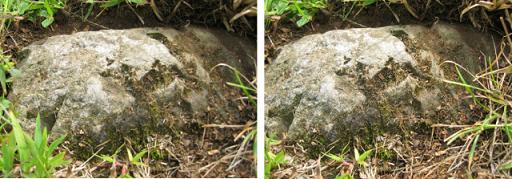
We now return you to your regularly scheduled discussion.
-
I’m supposed to be retired, but this other thing came up and…..
I have all three of those books. Interesting reading but not too much on the actual surveys as I recall. I’ll have to dig them out and reread them.
-
Heya all. I've been inspired by the efforts of several people on this forum to look for information about historic stations of my new home state, Hawaii. I'm concentrating on Oahu right now because that's the island I'm on, but I'll probably extend that to the neighbor islands as well. I've begun my search at the Hawaii State Library and am currently working with the book "Triangulation in Hawaii" by Hugh C. Mitchell of the C&GS, published in 1930 (Special Publication 156). I've found that all but two of the stations are present in the NGS database (they all have the appropriate 1927 logs) - the other two, Mokapu and Punchbowl, were probably reset in the '60s and '40s, respectively, but I want to double-check with the descriptions and coordinates in the book. When I get that all straight I'll mock up the triangulation network for Oahu.
I'm also going to look at the works of the Hawaiian Government Survey from the 1890s, as many of the 1927 stations were formerly used then, and see if I can come up with a network for that as well. And last, I want to see if I can photograph the old topo maps they've got at the Library to put online - they have some from the US War Department c. WWII as well as old canvas USGS/C&GS ones from the 1920s. Not a complete set for Oahu, alas, but I can try the Manoa library later.
I was wondering what other things people on the forums might try to do? Obviously, at some point I'd like to recover as many of these historic stations as possible (I've "found" one - I say "found" because it has an issue I'd like your opinions on once the logging on GC.com is fixed). But are there any other resources you'd recommend? Networks I should look for? People I should ask for data?
Thanks, and if any of you come to Oahu, I'd love to go benchmarking with you!
Hey! You’re horning in on my kuleana.


Just kidding! I’ve been wanting to get to this project for a while now. Right now I am tied up with personal business that takes more time then a full time job. Hopefully I can finish it off soon and get to important stuff, like benchmark hunting.
Keep me posted about what you find in the libraries.
-
Most of the compasses discussed in this thread have a mirror. From the pictures I can’t figure out how you would use that.
Can somebody explain how to use it, or at least direct me to a web site that explains it?
You fold the mirror partially open, sight through the slit/wire in the cover to the object you want to take the bearing of, and then use the mirror to read the compass. This way you can see the bearing object AND read the compass at the same time.
OK, thanks TillaMurphs. That looks easy. I’ll have to go to my neighborhood surveyors store to see what they have. Maybe I can play with one a little to see if it is better than what I have.
-
I’m more familiar with this type of compass.

It has a sight wire to line up on the “target” and a lens to see the reading on the dial. It’s pretty easy to understand. It does not have an adjustment for declination.
Most of the compasses discussed in this thread have a mirror. From the pictures I can’t figure out how you would use that.
Can somebody explain how to use it, or at least direct me to a web site that explains it?
Thanks
-
Palm, sewing How to use

Help! I'm getting too old to follow directions!
in Benchmarking
Posted
Maybe I’m just wasting bandwidth here but here is my take. As you know J 52 is part of a line. So I plotted G 52; H 52; J 52; K 52; L 52; and M 52 on Google Earth using the Coordinates in Geocaching. J 52 is conspicuously out of place.
If it was me I would be looking along US 89 between H 52 and K 52. The other marks are from 1.5 to 3 miles apart. But H 52 and K 52 are 6 miles apart. Is it possible there was an I 52? I did not think they used “I” as it was too easy to confuse with “1”. However there is enough room for two more marks there.
In this area US 89 goes northwest southeast.
HTH