

southpawaz
-
Posts
531 -
Joined
-
Last visited
Everything posted by southpawaz
-
I've been along that stretch of road and while looking for a different mark I found a different one of these (not in the database) that was set more as described in this one's description, flush on the end of a sawed off branch. I was surprised that it is in such good condition for having been there more than 50 years: I think you're right that this is really only a curiosity, especially with a good mark set in a monument just 50 feet away across the road. I probably wouldn't submit a report to the NGS given the questions raised about whether the tag is the mark. My guess is that when the C&GS did their second level run along here in 1951 they checked in to these USGS marks where they found them.
-
Your Best/Favorite Benchmarking pictures.
southpawaz replied to 2oldfarts (the rockhounders)'s topic in Benchmarking
From a couple weeks back, here's the hiker's first view of DT0714 ESCUDILLA LOOKOUT TOWER upon leaving the forest around it: And in a different vein, yesterday I was out for a ride along Historic Route 66 in the area of Seligman, AZ, where I discovered that one part of the history has been revived with the placement of a number of sets of Burma Shave jingles on modern style highway signs as seen in the background of this shot of FR0237 PENE. PENE's Burma Shave jingle is: Just This Once And Just For Fun We'll Let You Finish What We've Begun ????? ????? -
Here's one: CZ1945 PASS RM 3. After a database search and review of NGS marks set in Arizona in 1971, it looks like this is the only one in the state with a photo on gc.com that is the NGS disk, all the others were USC&GS disks.
-
Thanks for noticing! I've been working towards that goal at least with regard to Arizona for a while now, in conjunction with working first on the contest earlier this year and more recently as I've been traveling to find caches needed to complete the Arizona Delorme Challenge cache. I'm hoping to turn Apache Co. (northeast) red with a trip this weekend, and I have my eyes on a USGS level line running south from St. George, UT to turn Mohave Co. (northwest) red next week or the week after. Santa Cruz (south) and Greenlee (east) are going to take some doing, since neither county has a huge number of benchmarks and I've already picked off most of the low hanging fruit.
-
Agreeing here with Bill; my log would describe what I found at the location: is the culvert the same size and the road the same width as in the original description? Presuming there isn't one on this side, I'd also check the culvert on the opposite side of the road to see if the DOT put a mark on it on that side if they replaced the culvert, which might give you a date for the change. If the culvert currently there is the same size as described in 1935 (21x7 double box) I would also take a photo of what I found 1.1 feet north of the south end where the original mark was described as being located. Finally, I'd cross reference the PID for the reset.
-
And it might even be online. I found this which looks close on the map and by coordinates but the painted ID on your picture doesn't match their ID: Santa Clara Valley Water District site.
-
If the image is already uploaded to another web site, then when you are writing a post on these forums you can click on the small icon above the text entry box that looks like a picture of a tree, and it will prompt you for the url of the image. If you haven't yet uploaded the image, you could do so somewhere on the geocaching site then use that link.
-
Benchmark Picture Contest 2009 part 2
southpawaz replied to Black Dog Trackers's topic in Benchmarking
I was out Saturday driving along the Joshua Tree Forest Parkway of Arizona (so much more descriptive than US 93 or "the road to Vegas," isn't it?) and though I didn't have any data loaded, thought I'd try to stop for a picture of a benchmark with a Joshua Tree. Pulled off at the right spot to catch ET1037, too bad it's been destroyed. -
Sorry, the benchmarks listed on geocaching.com database are derived from a database maintained by a US government agency, the National Geodetic Survey, so the vast majority of the benchmarks are in the US and some territories. You might give this site a try on your side of the ocean: Trigpointing UK. Happy Hunting!
-
Here's a cacher's trail in southeast Arizona: The left eye is GC1N2ZX.
-
Your Best/Favorite Benchmarking pictures.
southpawaz replied to 2oldfarts (the rockhounders)'s topic in Benchmarking
Here's a story of one that got away. Friday I hastily planned a trip and headed out southeast to visit Characahua National Monument. Since it was a long drive, I had only loaded about 20 roadside benchmarks to hunt along the way and just done a quick radius search on GC.com for marks near the Massai Point earthcache in the National Monument and not seen anything close by. After doing the earthcache, I decided to hike up to Sugarloaf Fire Lookout, and while I was there I took a quick look around on the foundations to see if there might be a USGS tri-station but didn't see one. Today I was looking again at the area with the Scaredy Cat map viewer and lo and behold, what do I see but CY1305 SUGARLOAF, a USGS station set in 1936 (the same year the lookout was built) but not "adopted" by the NGS into their database until 2003. Adding to my chagrin, I must have walked right past it to take this picture of the lookout, and from the description, the station should be somewhere in the photo (if I'm not standing on it): And here's a view off the northeast corner of the lookout of the rhyolite hoodoos looking down into Bonita Canyon: -
I hadn't seen Buckner's site until I saw the recent thread about its whereabouts. Here are a couple disk types I found this week that aren't shown on his site. Both are set since 2000 so they aren't on GC.com. Here is DH5763 C 232, an Arizona DOT Right of Way Survey Control disk: and here's DH5783 WAUGHITAL, a Cochise County Highway and Floodplain Department disk:
-
Azimuth mark with its own RM? - and USACE disks
southpawaz replied to TillaMurphs's topic in Benchmarking
Signal lamps were used so that longer triangulation shots could be sighted accurately at night. Here's a sample photo I found in the NGS photo Library: And here's a picture of one that's been riding around in the back of my truck for quite a while, found at DV2217 QUARTZ: -
It looks like you found this one: SD0166 944 2396 TIDAL 4. When you've found a mark somewhere and are wondering what it is, another handy tool is this map viewer.
-
Your Best/Favorite Benchmarking pictures.
southpawaz replied to 2oldfarts (the rockhounders)'s topic in Benchmarking
This one may bring back some memories of your early days of benchmark hunting, Shirley. Here's the 110 foot lookout tower above ES0969 PROMONTORY. -
Your Best/Favorite Benchmarking pictures.
southpawaz replied to 2oldfarts (the rockhounders)'s topic in Benchmarking
I was up north on Friday, where among others I found ES0048 JACK, which had an unusual "witness post" nearby, making it hard to miss: The station is about 400 feet west of the sign. -
2009 Settings Contest Congratulations & Discussion
southpawaz replied to TillaMurphs's topic in Benchmarking
It was nice to find that package waiting for me when I picked up my mail this week. Now I may have to make a trip up to Zion so I have a visit to match the centennial coin. Not many GEOCAC logs in southern Utah, hmm... Thanks again for the contest and prize! -
Looky here what I found today. Not in the cache, but stashed under a pile rocks about 10 feet away from GZ. Still sealed, with a bottling date of 2002.
-
Your Best/Favorite Benchmarking pictures.
southpawaz replied to 2oldfarts (the rockhounders)'s topic in Benchmarking
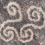
Very nice, great photo! Friday I went out to find DV1918 PAINTED, which takes its name from the Painted Rock Petroglyph Site. The azimuth mark is on one of the two rocky knolls at the Petroglyph Site, up above these boulders: And here's the view from the station itself, looking out over the Painted Rock Ranch in the floodplain of the Gila River: -
2009 Settings Contest Congratulations & Discussion
southpawaz replied to TillaMurphs's topic in Benchmarking
Let me add my thanks too, both to UNK1 for running the show and providing the great prizes, and also to those prodigious Arizona benchmark hunters (you know who you are ) whose prior logs on so many marks were a great help in keeping me focused on findable marks and not spending much time on DNFs. In looking over to the scoreboard thread, I notice that the mysterious setting 10 mentioned above by TillaMurphs fell in my found column. Looks like it was a typo in the scoring process from my last submission (which was a Setting 45 for 10 points), as the 45 is not reflected in the final scoreboard posting. As for the tough settings, from my notes there are no 33, 48, 50, 55, 56, 58 or 60s in Arizona. There is one 57 (CZ1500) but it's apparently inside a locked Tucson Water facility, so I didn't look into it any further, and also just the one 21 which was a bit out of my range. There are a number of 65s but most were further than I wanted to go, and I had already found the one that was most accessible and not too far from another distant mark I went after for the contest. Once again, thanks, and congratulations to all the other winners. -
Actually, there is, and it does make things a lot easier: Scaredycat Benchmark Viewer.
-
Your Best/Favorite Benchmarking pictures.
southpawaz replied to 2oldfarts (the rockhounders)'s topic in Benchmarking
Got a few good pictures on a trip south this weekend. Here's CG0608. The now dead live oak tree in the picture was used as a reference in the 1935 description. Here's the ghost town Ruby, Arizona, just over the hill from CG0605. The caretaker did a double take when I asked him to verify the location of the Pool Hall referenced in the description. "How'd you know about that?" That mark was an interesting old hand stamped pipe cap "adopted" by the CG&S when they ran their level line: A bit further on down the road, here's CG0609: And finally, here's an interesting disk I found just a few blocks north of the border in Nogales, CG0209: -
It sounds to me like they didn't measure from RM 1 to RM 2 to give a check on their measurements, but they did measure from the RMs to the station. The geocaching page doesn't include this information, but the datasheet does (from the geocaching page you can follow the link view the original datasheet) and find that the distance from the station to RM 1 is 22.036 meters at an azimuth of 006° 08'. Since you have found the reference mark, you'll want to reverse that azimuth to 186° 08' to go to the station.
-
Not clear which datasheets you are converting but if you have that down, it's possible to do exactly what you want on the NGS website. Go to the Datasheet Retrieval Page, and select the Datasheets button, which brings you to a query page that allows you to do a radial search (among other methods). On the radial search page enter the coordinates of your central point and the radius. When the search results come up, hit select all, then get datasheets. Copy the resulting page into a text editor, save it as a plaintext file, then you can run it through whatever program you're using to convert from datasheet to GPX, and you're all set. Happy hunting!
-
Went for a drive last Friday to pick up my 27th setting type: Setting 45 CF0205 Setting=45 10 points Claiming 60 point bonus for 27 different settings. Total points for this post 70. (Now hoping the score doesn't tighten up so much as to compel me to log all my one pointers)
.png)