

southpawaz
-
Posts
531 -
Joined
-
Last visited
Posts posted by southpawaz
-
-
Also, what about the USGS BM disc at the place others have seen? Could that be considered a replacement benchmark for the other BM?
The flagpole had a known horizontal postion and unknown vertical postition (elevation), while the USGS disk most likely had a known elevation and unknown horizontal position, so they would not easily substitute for one another.
-
Thanks Mike. Any suggestions on what the No. 3 means, on the post?
I'm guessing from my limited experience with USGS marks around here from that era that it's not the numbering of a reference mark for a triangulation station, since I don't think they were monumenting a lot of RMs. A few stations that come to mind: CG1052 single reference mark, chiseled cross (though that monumentation type might not have been appropriate for the area where this one is); while these three DU2086, DU2276, ET0856, each had no USGS reference marks set.
-
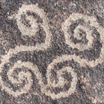
Started today logging finds from a week long trip to Utah a couple weeks back. Here's the best picture from the first batch of logs, HN0158 L 141 along the Red House Cliffs in southern San Juan County.
-
The NGS also harvests photos from the geocaching site logs, so there's a good chance they'll get them if you just post the photos with your log.
-
So I hike to the lighthouse again today; I say hike because it's a workout. Anyway I came across a topographic map earlier this week, its actually an NOAA ship tracking map, but if you zoom in it gives you a topo map of the entire U.S. [ http://shiptracker.noaa.gov/shiptracker.html ] with BM's listed.
Nice finds, thanks for sharing the photos! FYI, the 9s, 10 and 13 on the map are elevations, rather than an identifier or name for the marks.
-
Good find, thanks for sharing your photos. I don't recall what kind of GPSr you use, but I use a Garmin format PLSS overlay available from GPSFileDepot that usually will put me within 30 feet of a corner. Here's one I found last weekend:

T13N R15 E, S17 S18 S19 S20, Gila and Salt River Meridian.
And it's blazed and scribed bearing tree:

-
Not seeing Mytopo as an option with map preferences set to the "Leaflet" option.
-
Given the decreasing importance of passive marks, I don't think any agency is going to do anything to save it...as sad as that may be.
Heh! I actually had cause to do a level run off of one today.
-
Seeing where it is on the map, it is almost certainly a section corner of the Public Land Survey System. Monuments were set every mile at the corners of sections (section corners), and at the +/- half mile midpoint in between (quarter corners). The quarter corners were set to serve as the basis for further subdivisions of the section.
-
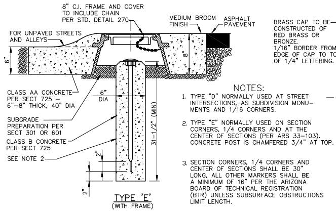
Here's an excerpt of the detail drawing showing how ours are constructed:
-
It is definitely a hand-hole, which may have a survey monument inside. Alternatively, there may be a gas or water valve below.
-
I'd really like to see a picture of this, if convenient.
This gc.com log includes a photo of the section corner.
-
howarthe, what you found is a section corner from the Public Land Survey System. Very few of these boundary monuments are included in the database of geodetic survey monuments maintained by the NGS, a circa 2000 snapshot of which is used by geocaching for its database of benchmarks. If you'd like to log this, I believe there is a category for these on Waymarking.
-
My 'caching friend & I found one today that neither of us can find on any database (nor do we know how to do this); we both forgot to get the coords (They're approx. 300' NNW of N34° 31.699 W112° 24.722), but took pics of the pipe cap marker. Markings were:
[around the outer perimeter of the pipe cap]:
U.S.GENERAL LAND OFFICE SURVEY-192
[inside that]:
PENALTY $250 FOR REMOVAL
[in the center area]:
13NT13N
S1 | R1W
___|
S12 |
R2W S7
How can we log this as a find, and more specifically, where do we look?
AeroMechAZ, what you found is a section corner from the Public Land Survey System. Very few of these boundary monuments are included in the database of geodetic survey monuments maintained by the NGS, a circa 2000 snapshot of which is used by geocaching for its database of benchmarks. If you'd like to log this, I believe there is a category for these on Waymarking.
-
With regard to the fresh flagging, I remember hearing a couple years back that the NGS was looking for a contract surveyor to do a new level run in that area, I think to replace some work that was going to be destroyed by the rerouting of the highway onto the new bridge, so they may have tied that into this level run.
If you end up not going back, I think you could write an adequate description using the To Reach from J 119 and L 119. As for local ties, with your HH2 coordinates, distance from the road CL and the witness post would probably be enough.
-

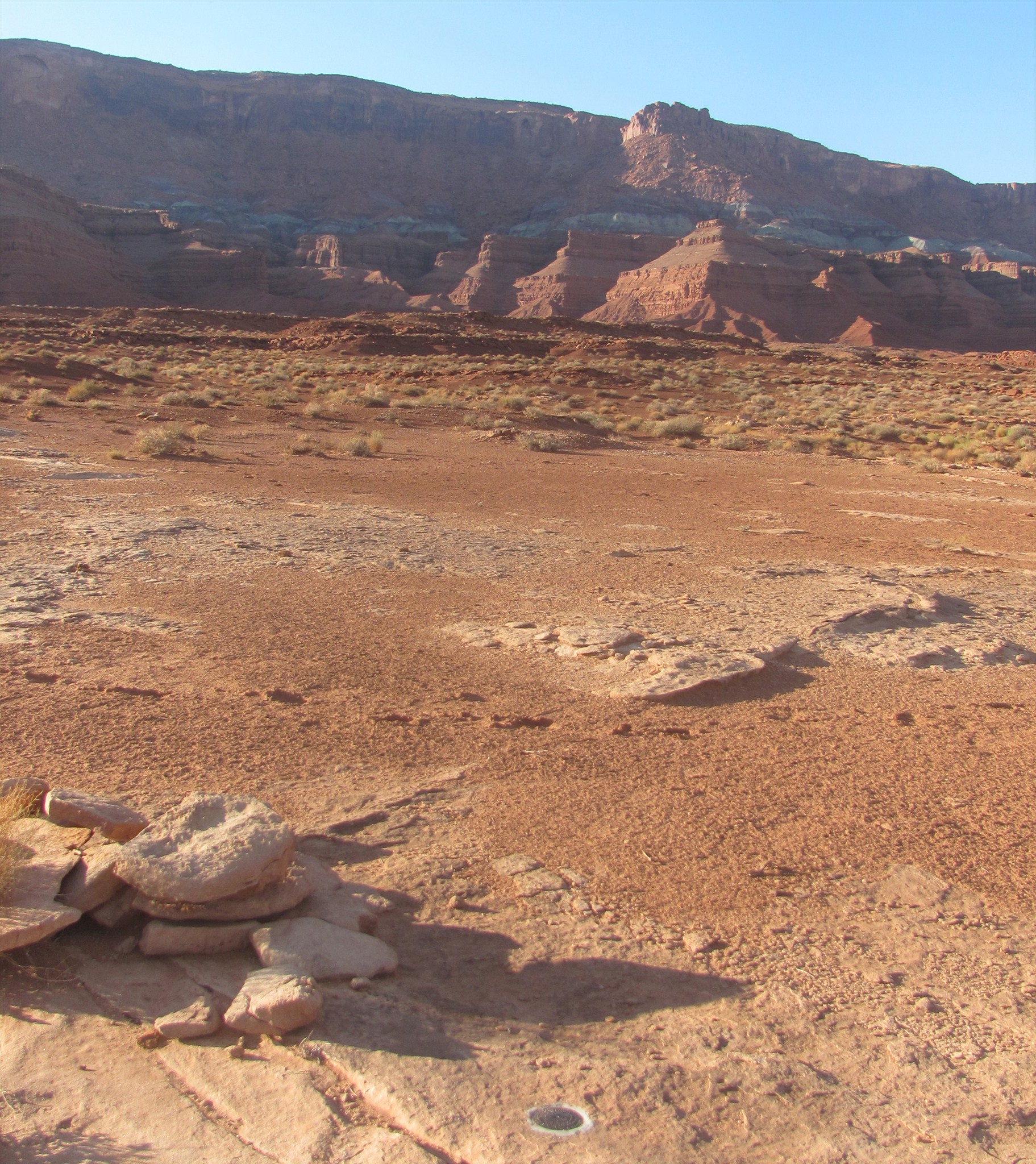
View of Four Peaks taken yesterday from the site of DU2034 CAMP on Pine Mountain northeast of Phoenix.
-
There is at least one USGS level run around here where the crew set some marks on stumps of sawed off branches, and a few of the marks were later incorporated into a C&GS level run. One example is CZ0600: "SET IN THE TOP OF A SAWED OFF LIMB OF A PALO VERDE TREE, ABOUT 1 FOOT ABOVE THE GROUND, REF. MARK 2184.0 STAMPED ON A METAL TAG FASTENED TO THE TREE." We didn't find this one, but we did find another from this USGS run that did not get a PID.
-
My guess is that it marks a 2.5 foot offset to an angle point in an underground water line.
-
I had the same reaction to this article as you did, Bill.
-
Way to go, John! Glad you finally found it.
-
Nice detective work to get past the erroneous scaled coordinates for DU0784. Hope you find it!
-
Thanks for that link, mloser. I just bookmarked it. Not trying to get off topic too much, has anyone here had much experience with the Russian GPS system (GLONASS)? I've been reading where a lot of the smartphones can use our and their systems......as well as some units able to read both at the same time. I was just wondering how accurate of a reading you could get utilizing both systems at the same time.
Our survey grade Trimble equipment at work is able to use both GPS and GLONASS satellites. With a full combined constellation, I generally am using 13-16 satellites yielding an estimated horizontal accuracy of approximately 1/8" to 3/8". When using only GPS satellites, I am generally working with a constellation of 5-9 satellites and an estimated horizontal accuracy of approximately 1/4" to 3/4". Bringing this around back towards being on topic, one of the major benefits of using the combined constellation is the ability to make measurements within our tolerance for accuracy when there are partial blockages of the sky - I can usually get a good shot up against a building with half the sky blocked when using the full constellation.
-
If you have free time and any energy left after the marathon, the level run from GQ0430 (first mark on the Arizona side of the border) south is a nice drive on a good gravel road that a rental car could handle.
-
My practice is to submit HH2 coordinates for bench marks with scaled coordinates unless my reading is within GPS error of the scaled position. For triangulation stations, if I locate an azimuth mark, I will include its HH2 coordinates but I don't submit coordinates for reference marks with their own PIDs and scaled coordinates since those are easily calculated. I rarely spend much time writing new descriptions or to reach information; with GPS other resources available I don't personally see much need to do so.
Any idea what these mystery nails are?
in Benchmarking
Posted
When we are marking a location where a monument is to be constructed by another party, we set 4 60D nails in a crisscross pattern so that they can build it in the right spot needing nothing more than a string line to know where it should be.