


ryguyMN
-
Posts
113 -
Joined
-
Last visited
Posts posted by ryguyMN
-
-
I would hold off on buying a newer model nuvi for a couple months until bugs related to the latest map update (2009.11) are worked out. There are reported issues with the nuvi that will literally have you driving in a circle (I call it "looping"), traffic services not working properly, and turn indicator that will tell you a different direction than what the map reflects on the screen. I don't know if these issues affect the 550, but the 2X5 and 7X5 series are impacted. My 350 with the latest maps seem to be working flawlessly, but the 255 seems to be buggy.
-
Supposedly Magellan issued firmware updates to increase performance and add additional features for the Triton line, as I read on another site.
Here are some highlights of the new update:
- User Experience: Users will now be able to enjoy enhanced features including the ability to load and search 500 waypoints, trails with 5,000 track points, and 20 routes; the implementation of the NMEA communication protocol for both USB and Serial communication; trail functionality; and improvements like the ability to select unique trail color in addition to other user-defined trail attribute definitions; and several other user interface and map display improvements.
- VantagePoint Software: Users will now be able to take advantage of a Window system trap application that alerts them of new Triton software updates. Additionally, the updated trails functionality and NMEA communication protocol are included in the latest VantagePoint software release to allow users to replay and customize their trails and perform GPS logging.
- Product Accuracy: The accuracy of location information has been updated with improvements in latitude, longitude, heading, bearing, distance, date, time, elevation and speed. The accuracy of the internal memory and SD Card memory readings has also been improved.
- Searching: The ability to search for waypoints, geocaches and other place destinations is a vital part of an outdoor GPS device experience. Three areas of search-related improvements are the ability to search user data; the ability to search geographically (”nearest to”) a point of the map; and the ability to search for places within a map.
- Sensors: Improvements have been made to the functionality and performance of the electronic 3-axis compass and digital barometer; additionally, sensors are only used when necessary, extending the battery life. Two Triton models come equipped with sensors — the Triton 500 and the Triton 2000.
- PC and GPS Device Communications: A warning message to users trying to connect their Triton device to their PC for the first time will no longer be displayed as a result of an improved PC connection with certified Microsoft Windows USB driver.
- National Geographic TOPO! Explorer: National Geographic SuperQuads — a unique combination of USGS 1:24,000 topo quads, 4-meter aerial imagery and hybrid maps — are now available on Triton GPS devices through TOPO! Explorer and TOPO! Explorer Deluxe software products. New improvements include automatic Triton software updates, updated map export, complete Triton memory management for both user data and NGMaps and updated online user documentation.
- Topo USA (powered by AccuTerra): Intermap Technologies branded AccuTerra GPS map data is available to Triton users for online download now, and will soon be available in popular retail outlets. The retail product will be available on “plug ‘n play” SD Cards, which can be simply inserted into compatible Triton devices for instant access to national GPS maps. The vector-based interactive maps include property boundaries for federal, state, and local lands; accurate hiking and motorized trails; and over one million outdoor-specific points of interest. Both regional and complete US coverage is available.
- User Experience: Users will now be able to enjoy enhanced features including the ability to load and search 500 waypoints, trails with 5,000 track points, and 20 routes; the implementation of the NMEA communication protocol for both USB and Serial communication; trail functionality; and improvements like the ability to select unique trail color in addition to other user-defined trail attribute definitions; and several other user interface and map display improvements.
-
That a boy, trainlove! Looking forward to having WAAS back on my SporTrak Pro.
-
If you like the touch screen features like the nuvi, then the Oregon is the way to go. If you are considering next-gen units, then the Colorado should be in that conversation too. It has received a GPS chipset and software updates since it's been released, and is now a great performing unit. If you're open to any handheld model, then you might want to look at the GPSMAP 60 series as well for a mature, all-around great performing unit.
-
What firmware and GPS firmware were you running?
Setup/System/Left Soft Key/Software version There are 2 numbers. The latest is 2.70/2.80
Software Version 2.70 - Just updated to GPS Software Version 2.80.
What is the difference between 2.70 & 2.80?
Thanks
RJ
The update 2.80 is tied to the GPS chipset only inside your Colorado, and in thoery, improves performance and functionality of GPS tracking.
Software 2.70 is related to the operation and performance of the Colorado outside of the GPS chipset (application fixes, additional software features, etc.)
-
Now we need to find a non-US site that has updated firmware for pre-eXplorist models!

-
(To say that the Triton is the closest thing to paperless you can get with a Magellan is way off. I've used an eXplorist 500 for over two years and I love it.)
Yeah, but there's more steps in the middle to make it happen. I know it's older, but it's not like Garmin's approach with the Colorados and Oregons. That's the way it should be.
-
Name/Model of GPS: Colorado 400t
Rating (1= 5= ): 4
Advantages: Pretty looking topo maps, ability to load maps on top of each other, paperless caching, accurate, does auto navigation when necessary, barometer trending for hunting and fishing, respectable battery life using NiMH rechargable batteries.
Disadvantages: Text entry is a b*tch, a little pricey.
Consumer Comments: Overall, I'm pleased with the Colorado. It does what it's expected to do. For me, a score of 5 is close to perfection, and there are some quirks like how text entry is handled and some other small bugs that need to be hammered out that keep it from achieving that score.
-
Okay well actually I know how to use it well but am not sure if I am able to hook it up to the comp or if I need to manually enter geocaches. Also I am looking on line for the user manual pdf and if I can put any updates in it. I just had it given to me I dont think it was ever used but I know its old. Works good though.
Yep, you have to manually enter geocache information. For Magellans, the Triton is the closest to paperless caching as you'll get.
-
nuvi 2xx
It's firmware for the GPS receiver chip.
Didn't see any chipset updates for the nuvi 255 using WebUpdater.
-
OK, I have done some testing and some of this may be known... When the Colorado is in "drive mode" it will not record barometric pressures. The other night I accidentally left my Colorado 300 attached to the USB port on my computer over night (after "ejecting" it from the OS). The GPSr remained on and in "drive mode" all night. When I looked at the pressure graph in the morning, I had a straight line from where it was when it was connected to the PC to where it was when the until was physically disconnected and turned on. This doesn't really surprise me.
After that point, I saw another incident of "straight line" pressure graph, but this time the GPSr was not attached to the computer for that whole time. I had connected the GPSr to the PC to transfer track logs, etc. and then disconnected it and left it sit on the desk over night. In the morning I saw a straight line pressure graph. I am testing this one once again right now as I type this. I got to the office this morning and I quickly attached the GPSr to the laptop and transferred my track logs to the PC, now it has been disconnected and is sitting on the desk waiting lunch time for me to turn it back on and view the pressure graph. Hopefully The graph will look "normal" and not be another straight line...
OK, I performed a brief 3 hour test this morning and the results aren't "good". I ask any of you to repeat my test and see if you get the same results:
- Turn on "Save Always" for your barometer
- Run your GPSr as normal for a while to show it is recording pressures
- Turn GPSr off (optional)
- Attach GPSr to your computer and enter drive mode
- Disconnect GPSr from computer and unplug cable
- Leave GPSr sit for a few hours without turning on after disconnecting from your computer
- Turn GPSr on and look at your pressure plot
After following those steps this morning, I got the following pressure plots:
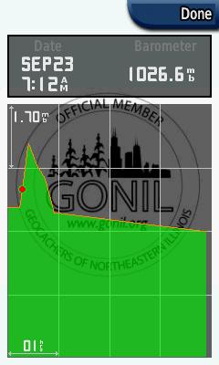

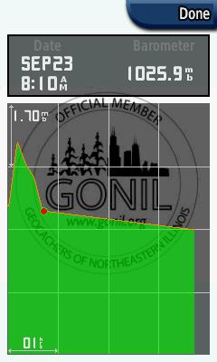
You will see that the pressure recorded normally up until 8:10 this morning, which is when I connected it to the computer here in the office to put it into drive mode.
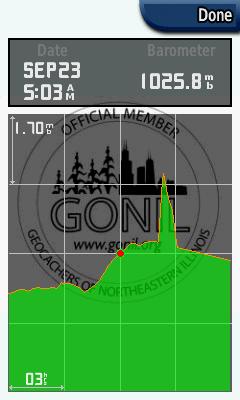
I also noticed another barometer graph issue that others have seen and it is shown here:
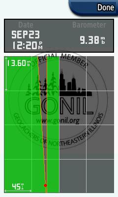
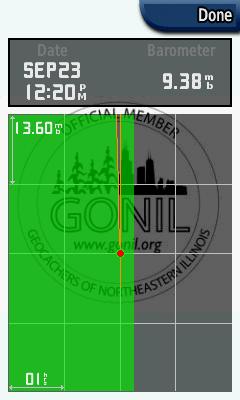
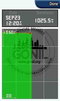
Notice that for these last 3 graphs all that was changed was the time scale, but for some reason when the time scale was set to 3 hours, the barometer reading jumped from 9.38 mb up to 1025.5 mb. This is a bit odd to me...
That doesn't look good at all. You might have to do a master reset to clear the barometer data if you already haven't done so. This might sound silly, but have you confirmed in the system menu that 2.7 is installed? Also, does it look like it's trending correctly when the unit is ON?
- Turn on "Save Always" for your barometer
-
OK, I have done some testing and some of this may be known... When the Colorado is in "drive mode" it will not record barometric pressures. The other night I accidentally left my Colorado 300 attached to the USB port on my computer over night (after "ejecting" it from the OS). The GPSr remained on and in "drive mode" all night. When I looked at the pressure graph in the morning, I had a straight line from where it was when it was connected to the PC to where it was when the until was physically disconnected and turned on. This doesn't really surprise me.
After that point, I saw another incident of "straight line" pressure graph, but this time the GPSr was not attached to the computer for that whole time. I had connected the GPSr to the PC to transfer track logs, etc. and then disconnected it and left it sit on the desk over night. In the morning I saw a straight line pressure graph. I am testing this one once again right now as I type this. I got to the office this morning and I quickly attached the GPSr to the laptop and transferred my track logs to the PC, now it has been disconnected and is sitting on the desk waiting lunch time for me to turn it back on and view the pressure graph. Hopefully The graph will look "normal" and not be another straight line...
I don't think this is an issue with the barometer with "drive mode" since the unit isn't receiving any kind of GPS signal or reading while connected to the PC. The PC is only providing enough power to the Colorado to function as a drive with communication going on through the USB cable.
-
yes backlight needs to be adjusted to the specific situation. Pretty quick click, set, close.
Regarding the occasional lockup when booting the unit up...is it possible it is due to not depressing the on/off button long enough? Mine has locked up twice and I associate it w/ not fully depressing the button for a sufficient enough time...is that possible?
I've had this happen a couple times. Now I train myself to hold the power button down until I see the Garmin logo appear.
-
just installed and all is well other than the darn backlight. They really need to fix that so it stays the way you had it previously. I can't stand having to adjust it every time i turn it on. Though, power on cycle is incredibly fast now!
Somehow I think this is by design and I wish Garmin would reconsider. The user should be able to dictate how much backlight to start with, not the manufacturer. Next to text entry, this is really the only other nuisance I have with this unit, otherwise it operates great.
-
2.7 comments:
-Tested the barometer and it does work! Will post pictures later, but trends similar to previous postings in this thread. Tested over 12 hour period.
...
I am not so sure that this is fixed. It is definitely better than before, but yesterday I noticed a couple items which I need to research. First off, when my scale was set to the 45 minute resolution, I still had a "trend to zero" for the period immediately prior to turning it back on. When the time scale was adjusted up to 1 hour the trend changed to something that looked realistic, but I still saw something out of the ordinary. I was having thundershowers (thank you Ike) and I noticed that when I turned the GPSr on after an overnight of being off, I had a "spike" of a 4-5 millibar increase in pressure that dropped back down over the next 15-30 minutes. I saw this same type of "spike" several hours later after I had power cycled my GPSr, but not near as major a change in pressure.
I am also starting to have my serious doubts about the data being recorded/displayed. In my readings yesterday, I was seeing readings in the 1003-1012 millibar range, yet today when I scroll back to that same time frame, I am seeing values in the 998 millibar range with no "spikes" as I saw yesterday. THis seems as though it requires a bit more methodical examination.
Hmmm...did you ever do a hard reset after upgrading? I noticed one quirk with the barometer trending after power up following the upgrade to 2.7 when I first started testing. When I opened the barmometer screen after having it on for 15-20 minutes, you could see the plots correctly, but then all of sudden like a half second later, they "smoothed out" with a straight line between plots just like pre-2.7. Doing a master reset seemed to fix the problem and re-caliberation of current pressure. You might still have some old data that needs to be cleared out.
-
2.7 comments:
-Tested the barometer and it does work! Will post pictures later, but trends similar to previous postings in this thread. Tested over 12 hour period.
-Colorado does seem to boot up faster.
-Noticed an improved accruacy error number while indoors.
-This has occured with previous revisions, but I do get a quick "low battery" popup while using freshly charged rechargeable batteries after 5 minutes of use or so.
Overall, I'm pretty impressed with this unit now. I don't seem to get the drifting issues that others have experienced. Text entry UI is still a little quirky on functionality, which hopefully can be improved over time.
-
Ok. Sounds like it is more common to use the elevation/altitude calibration rather than the baro pressure..unless you're near an airport.
Anyone have an idea on how capable the home weather system baramoters are? I have a weather station...
it reads 29.68 / 1018.8
whereas weatherunderground reports downtown Walnut Creek reading 29.95 in / 1014.1 hPa and falling.
whereas weatherunderground nearest airport (10mi away) reads 29.96 / 1015 - but data is an hour old...
It all depends on elevation, but in your situation the 29.68 seems a little off if there is little change in elevation.
-
I'm going to do some testing once my rechargeable batteries are fully charged and try 6-12 hour plots.
-
Thank you Garmin! We appreciate the fixes for sure. Now, if we can please have you work on:
1) Adding the ability to Average Waypoint coordinates, and
2) Adding a Track Manager (like the Oregon) with options, such as viewing multiple tracks.
Amen brother!!! I'm with you on exactly those two issues. I'm writing a letter to Garmin to ask about those two on Monday.
My Barometer also now works beautifully! Me happy.

Wile your at it:
3) More user-friendly text entry
Yeah, I keep going on about it every chance I get. The rotary phone style text wheel really bothers me.

How else would you enter text other than how it's done?
My idea is to display the alphabet on the screen and be able to use the arrow keys inside the rocker to select a letter. One of the gray buttons could be used to toggle between alpha, numeric, and special characters.
-
Duplicate post.
-
I would stay away from Magellan until they show a commitment of continued support of its products.
-
Available currently only via web-updater
Changes from version 2.60 to version 2.70:
Improved accuracy of altimeter for large altitude changes.
Fixed text writing on top of itself in some geocaches descriptions.
Fixed freeze when loading some geocaches descriptions.
Fixed issues with power off pressure trending.
Added support for downloading geocaches written using Groundspeak v1.1 extentions.
Improved map drawing performance in some situations.
Fixed 3D View not showing detail from supplemental maps.
Fixed waypoint and geocache symbols not updating on the map after being changed.
Fixed issue where the Colorado would temporarily stop responding after a spell search.
Fixed issue with elevation over time plot.
Fixed issue with position format not saving over power cycles.
Fixed issue with display of selected location config field.
As for this versions claims to fix the barometer, I'm beggining the testing process right now.
Thank you Garmin!!! Hopefully everything works as advertised.
-
I don't think there is anything free but for Minnesota lakes, I recommend LakeMaster Minnesota maps.
-
I've never have install a full version of City Nav before, but even 8 hours doesn't sound right for just one state. My upgrade to 2009 from 2007 for the whole US took only 2-3 hours on a nuvi.


Garmin Dakota?
in GPS technology and devices
Posted · Edited by ryguyMN
I hope the Dakota is still a ways off from release. The latest Oregon firmware has been in beta testing for some time and the Colorado hasn't seen any updates in over 6 months. I'm no genius, but get your current products right before releasing new models. Yes, I know Garmin wants to make some money, but pissing off your current customer base is going to leave you with nothing. No customers = No profit. Look at the mess Magellan got itself into.
"Those who forget the lessons of history are doomed to repeat"