


groundhog123
-
Posts
116 -
Joined
-
Last visited
Posts posted by groundhog123
-
-
3 hours ago, cerberus1 said:
Yep. If a next time, making a note for adoption on the cache page, or grabbing 'em before leaving helps too.
")
Yeah, would’ve done that except in the process of hunting for a house and the terrible task of moving, I completely forgot them until afterward.
-
I recently moved to a new city so therefore I am unable to maintain the two caches I have out near my former hometown. What options are available for these caches other than archiving them? Can other geocachers adopt them? I still pass through the area on occasion, but would not have time to maintain them them since they require a fair hike to get to. If I cant adopt them out, I will remove them and archive them. Thanks for your helpful tips.
-
More to the point, if you don't want to have to go through this exercise again down the road, it's critical that you don't have the original type adhesive!I wasn't sure how critical it was to have the original type adhesive...
Very good point.
-
Do it right. Fix it yourself.
Sounds like a plan to me. I wasn't sure how critical it was to have the original type adhesive, but I guess its not a big deal. I guess it would be a good idea to keep the silicone or RTV off the button thingies. Thanks for the advice!
-
The rubber rand around my Legend HCx is coming loose. I know this has been a problem on the eTrex units. I searched but didn't find a suitable post. I am curious how others got this resolved on their units. I have contacted Garmin and they want me to send in the unit for the exchange of a refurbished unit at a cost of about 50 bucks. This seems a little excessive just for a freaking rubber band.
 What have you done?
Thanks in advance.
-
xImage! Exactly what I was looking for. Thanks a ton!
-
I remember that a screenshot from a Garmin GPSr can be saved as a jpg file on your computer, but for the life of me I cannot remember how it is done. Would someone be kind enough to provide instructions. I searched and was unable to find it.
Thanks in advance.
-
I was looking around to find a shelter of some kind (as light as possible
 ) when I found this hammock/fly combo, "Hennessy Hammock Expedition A-Sym Hammock" on REI.com. REI.com's description said it could be used as a tent on the ground, combined with your hiking sticks. Does that work? Depending where you go in my area, there aren't always trees... advice?
I own the Hennesy A-Sym Ultralight (I beleive thats the name). I love the hammock. The one main drawback to me is that I am not comfortable in colder temps. I have tried pads and other suggestions but still get cold below 45 degrees. It is great for warmer temps......and comfy. I have set up the hammock on the ground using hiking poles and it can be done. I have never actually slept in it this way but it certainly is possible. Of course you would want a pad. Be sure to protect the bottom of the hammock. Go here to learn more about Hennesy hammocks>>>>> http://hennessyhammock.com/
-
I solved an entire mystery cache with Street View. You had to drive from point A to point B without hitting a stop sign. Did it without using a pint of gasoline.
WOW, you are so green!

-
Yes you can and the cable required to do so should come with the unit. It came with mine in the box.
-
My username came from the type of metal detector I use for treasure hunting....... a Garrett Groundhog. The 123 represents me (1), my wife (2) and our daughter (3).
-
I could care less if I am FTF or not. I have had 1 FTF purely by accident and cannot even remember the cache now. If others are into it, thats great. Its not a race to me. Its all about the hunt.
-
I have had the Garmin Legend HCx for a year and have never had a problem. Its almost dead on all the time and does not "bounce". I love it.
-
The local DOT or material test agency are most likely studying the different grades of sign sheeting. Whether it be by public input or close to an area where there is an engineering office or material test division, who knows. The green signs give it away. They are various grades of reflective sign sheeting.
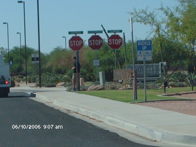
They're really serious about wanting you to stop in Gilbert, AZ. The cache, GCTPZP Should I Stop or Should I Go??? is at a location where there are a 4 stop signs. Not a big deal at a 4 way stop, unless they're all for the south bound direction.

-
Welome to the sport from a NE Texas geocacher! I would first recommend learning all the varieties of snakes, their habitats and habits in your area. There are only 5 poisonous snakes around Tyler.
1. Copperhead (most prevalent and in wooded areas)
2. Timber rattler AKA Canebreak
3. Water moccasin
4. Coral (very colorful and very poisonous but would have a hard time biting you)
5. Pygmy rattler
You will most likely encounter few poisonous snakes (unless your around W Texas). Most will be a non-poisonous variety. Remember, all snakes serve a useful purpose and should not be killed.
Happy caching
Oh, and don't go pokin' your hands in places they shouldn't be. Thats what sticks are made for.
-
I visit both stores and REI is by far my favorite. I am more of a backpacker, paddler, bicycle type.
-
My wife and I are Cachers that really do not enjoy the urban caching scene. We do grab some on occasion but we prefer the hikers. We are looking for trails and parks with multiple caches in the Central Texas area.
Any suggestions would be appreciated.
Thanks,
Team CenTex92
You might try Lake Goodwater trail. It is a nice trail along Lake Georgetown with some geocaches along the way as well. I think it is about 16 miles long and was being extended the last time we were there.
-
Hi I was wondering, has anyone joined this hobby by simply finding one of these caches by mistake? I know that you can print off the paper that says "Hi if you found this by mistake... visit geocaching.com". Has anyone ever done that? I think there might be some cool stories out there!

Thats exactly how I got into geocaching. Sat down near one to take a breather on a trail Arkansas and there it was. We signed the logbook, logged it online and the rest is history.
-
Hi- Im new to this amazing world and have a megellan triton 400 that I dont know how to use. Ive found the instructions for my gps to be vague and nonspecific. I found my first cache by accident and didnt know what it was- started researching this weird little bottle of strange names on google and found this site, ran out and bought a gps and now.... What. Went out today and tried my skills, or lack of them. I think the problem is I dont know how to read the gps and am not finding it to be newbie friendly. Any and all suggestions would be appreciated. Thanks in advance. Loraine Haley LoraineFTW1971@aol.com
Hey Loraine, Welcome to the game of geocaching. I think once you get it figured out, you will have a blast. Sorry, but I can not help you with the Magellan Triton. I know nothing about them.
BTW, I am just down the road from you in Lindale.
-
HA! Looks like I fall in the largest group! My daughter would say OLD.
-
Overall, I enjoyed watching the video and would most likely watch a geocaching based television program. I think it would have to also include other adventures and much traveling to extrordinary locales. I really don't understand why people were turned off by the snake scene. There are quite a few snake oriented shows on Discovery and other channels which I thouroughly enjoy as well. I am not sure how well a geocaching oriented show would appeal to the general public. Afterall. what percentage of the population truly understands or even cares about the game of geocaching. At any rate, my vote is....go for it.
-
On my 76CSx I press menu from the map setup information screen and choose "Hide City Navigator...". When I want to display the CNA maps again, from the same menu I choose "Show City Navigator...".
Same on my Legend HCx. From "Map setup" select the map screen. From that screen press the Menu button. You should see "Hide (or Show) City Navigator and Hide (or Show) Topo 2008. If you want to hide CN just highlight it and press enter. It should then indicate Show City Navigator at which point Topo 2008 will be the mapset displayed on the unit. There is no reason to select each region and uncheck it. I think that is the way at any rate on the Legend.
-
This is a slightly different method using the auto routing feature of CNNA NT 2008.
With a route enabled.......from the "turn-by-turn" screen

select profile

and the elevation profile of the route

Not sure how useful the elevation profile will be in real world conditions, but its kinda cool to look at.
-
Yeah, I'd love to see it available on more screens (trip computer, map screen).
groundhog 123, not only will you need xImage to grab the screenshot, you'll need a web host or some sort of free image hosting service to post it. And if you do the latter, you'd probably have to convert it to .jpg, because I think xImage outputs in .bmp.
One way to the profile screen:
Main Menu

Saved route

Route

Select Profile

In this case, I used Off Road Data

and here is the profile page for the selected route

I have CNNA NT 2008 and TOPO 2008 installed on my device
 ) when I found this hammock/fly combo, "Hennessy Hammock Expedition A-Sym Hammock" on REI.com. REI.com's description said it could be used as a tent on the ground, combined with your hiking sticks. Does that work? Depending where you go in my area, there aren't always trees... advice?

Moving to a new city
in General geocaching topics
Posted
I’m only about two hours away, but too far to provide decent maintenance.