


cjf
-
Posts
93 -
Joined
-
Last visited
Posts posted by cjf
-
-
I'm in!
-
Whoppeee! Another contest! I'm in.
(Don't tell my kids.
 )
) -
Congratulations, Art Man!
I'm thinking that we should form an exclusive club for benchmark hunters who get a "two-fer."
 My application is in Morro Bay Mysteries Thread
Or perhaps a new contest ........

cjf
-
FV1101 and FV0401 are the same mark. I have sent a note to make the appropriate correction. Thank you for helping us keep the National Spatial Reference System data as up to date as possible.
You're welcome! (How cool is this? A "thank you!" I cut and pasted it into my GSAK notes for these/this benchmark as a momento.)
Colleen,It is great to have someone to hold the other end of a tape, which has only happened to me a couple of times. I end up running the measurements by myself and have gotten decently good at it. It gets more difficult if thre are obstructions between the station and RM but I have adapted. I have no other real choice. If you can prepare, there is nothing better than using a compass and tape to get a precise location for the mark. The arrows are not always 100 percent accurate and at the very least they are only as accurate as tiny arrows on a disk can be.
Duly noted. All the helpful advice about Black Hill also copied into GSAK notes so it's there for next year.
-
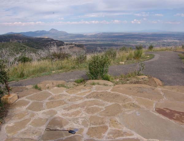
Another photo from Morro Bay Excursion (had server problems when I tried to post this yesterday).
View from something found on Black Hill (FV1654)
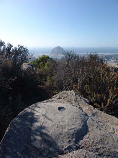
Kewaneh & Shark
I thought that looked familiar. Here's my shot of the same view...The benchmark in your photo is now under several inches of direct (if it's still there). I started comparing a photo I have of the same area with yours - no benchmark visible and the rocks are more buried. I'll try again next time I'm in the area.
cjf
-
Gentlemen,
I always use the NGS datasheets downloaded to GSAK.
 (For proof, witness my cry for help prior to my Morro Bay Weekend: NGS Datasheet Page - California Down? ) I must confess that sometimes the datasheet details make what's left of my brain go numb.
 Next year I'll climb up Black Hill will additional gear - tape measure, probing device (perhaps I need to finally spring for a metal detector?), and appropriate relatives gleaned from family campout to assist in search. It was just me and my dad this year. My dad and I must have looked awful funny up there this year. I'd have him stand on an RM and point in the same direction as the arrow on the RM. I'd go to the other RM and start walking in the direction of my arrow. When I reached the point where my dad was pointing at me I started looking in the dirt for the main benchmark.
 Next year I'll grab an uncle or two, perhaps a husband, bribe daughters....... I'll have a whole slew of people up there standing and pointing!
I'm just glad to know it wasn't just me and that something was a little odd about those benchmarks.
BTW, Breaker's Cafe mentioned in FV0401-FV1101 is now Dorn's. Great place to have dinner (and a grab a benchmark or two to boot!).
Colleen
-
-
I held off logging my Morro Bay (San Luis Obispo County, CA) benchmark results for a few weeks because, frankly, I was confused. I kept hoping that the passage of time would make things clear. Didn't happen.
The first mystery: FV1654
As you can see by the note I posted, I found several benchmarks on top of Black Hill. I thought I had found the reference marks, took my pictures, and headed down the hill. It wasn't until I got home and started comparing the benchmark photos to the datasheet that I realized something was funny. Benchmark markings were similar, but not the same. Also, there was no NGS entry for 1992, but one of the RMs was clearly cemented in 1992 because it's written in the cement. It was all very odd. I'm still confused.
The second mystery: This appears to be a "two for one" visit benchmark. Is it FV1101 or FV0401? What's up with that? Both datasheets refer to the same Centennial Stair monument and the benchmark on top of it. What the heck, I logged them both with a reference to both designations. (The contest is over, so who's counting?
)I have a year to mull it all over. I'll be back next fall for the next family campout and can revisit the sites.
Colleen
-
The rest of the story..........
I checked my email just before I left for my weekend trip. Lo and behold, there was an email from the National Geodetic Survey! There was my initial email in the chain which was forwarded to a computer specialist with a message "Please help this customer!" (Hooray! I'm finally someone's customer!) The email to me stated that they had extracted all the data for California and it was now available. I was able to quickly download the information and take it with me in GSAK and my PDA.
I feel so special.
Colleen
-
Perhaps the "big quake" finally hit and California has slid into the Pacific Ocean, never to be seen, or surveyed, again. No need in keeping the archives after that you know!
I don't think we slid off (yet) - there's no water in my backyard!
 Have you tried any other California counties?
Perhaps you should contact NGS <ngs.infocenter@noaa.gov> about this issue.
I tried Santa Clara and San Francisco - both had the same "Sorry no data exists" reply (and I know Santa Clara is not in the drink because that's where I am).
I also sent an email to the address provided. Thank you!
Colleen
-
Since Saturday morning (9/30/06) I've been trying to download the San Luis Obispo County, California, yearly archived datasheet from the NGS website. The message I get when I select download is "SORRY - Currently no data exists for |CA|079|SAN LUIS OBISPO."
I checked a county I'd downloaded before, and that one is also currently non-existent.I'm leaving this Friday for a Morro Bay weekend and would love to have all the datasheet information in GSAK and my PDA. Any suggestions or help the forum members can provide will be greatly appreciated.
Colleen
-
I had heard that some windshields block satellite reception, so when it came time for me to get a new car last winter I took my GPSr with me. The first "test" the prospective vehicle had to pass was the satellite reception test.
I know - not much help to csonni, but if someone out there is in the market for a new car - take the GPSr with you when you're shopping.
cjf
-
-
Today was my first day back at work after my vacation, so you can understand that I was in need of a little morale boost. And what did I find in the mail when I got home from work? My contest pin and a bonus pin. Whoopee!!!!!
Thank you!
John & Shirley - 2oldfarts (the rockhounders): If you'd like we can take a picture of the back of the pins as well!I'm pathetic. I actually had to check the backs of the pins to make sure I hadn't missed anything!
Colleen
-
-
Just home from vacation. Address emailed this morning.
Alas, no serious benchmarking was attempted.
In the interest of family harmony (i.e., rolled eyes of teenaged daughters even though I tell them they should be happy to have a mom with such an interesting hobby  ) and highway safety (husband claims there's not room for our truck and 28 foot fifth wheel trailer on the side of the road near the benchmark) I curtailed my benchmark hunting during this trip. Oh well. It was a fun trip to the Four Corners area anyway.
 -
Was only able to find time to log one benchmark while on a business trip to Santa Rosa. (It's a shame how work can interfere with one's hobbies.)
-
Finds from 6/11/2006:
And this is one I found 5/6/06 but didn't log at the time (Note to self: Read contest rules more thoroughly!):
-
-
I don't think it's DC1965, Garnet. I considered that but the disks I found clearly say "GAR." Also, my coordinates were almost dead on for GAR: N 32 58.654 W 116 31.176 (I have a fuzzy fuzzy picture of the benchmark and my GPSr).
I like Klemmer & TeddyBearMama's suggestion of why the disks are so poorly marked.
 I'd never seen disks like that. I've seen them scraped up, worn up, and in otherwise bad condition, but nothing ever like this!
 -
I was hunting down benchmarks this weekend and came across this: DC1976.
It wasn't until I got back and started logging finds that I realized that what I found (3 disks, all including the word "GAR") was far different than the one disk mentioned in the datasheet (which was a "GAR" benchmark). But the coordinates and location description was right on target.
I haven't found any other datasheet that fits what I found.
Take and look at the note and photos I posted. What did I find? Any ideas?
Thanks,
cjf
-
I spent the weekend exploring Anza-Borrego State Park--some fun finds!
AI4534/1800/No/Yes Note: the judges subsequently weighed in and advised me that this really doesn't quality as the oldest in the county. It's being considered an 1899 date. Oh well. cjf 5/25/2006
I may have one more to post, but I need to do some research to figure out why what I found is so different than described by the data sheet.
-
-
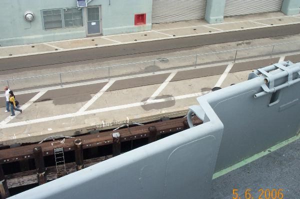
And now for something completely different:
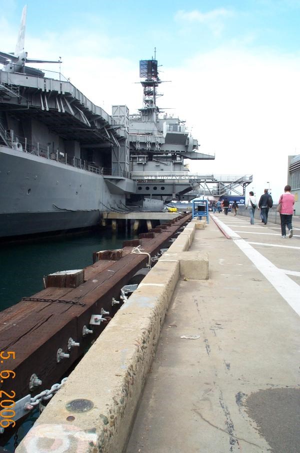
That benchmark is DC0888, the rivet next to it is DC0890. They're very conveniently located next to the Aircraft Carrier Midway, which is now a museum.
I also took a photo of the benchmarks from the flight deck of the Midway (the dark circle on the curb is the benchmark, right below darker oval splotch in the paving):
 )
) (For proof, witness my cry for help prior to my Morro Bay Weekend:
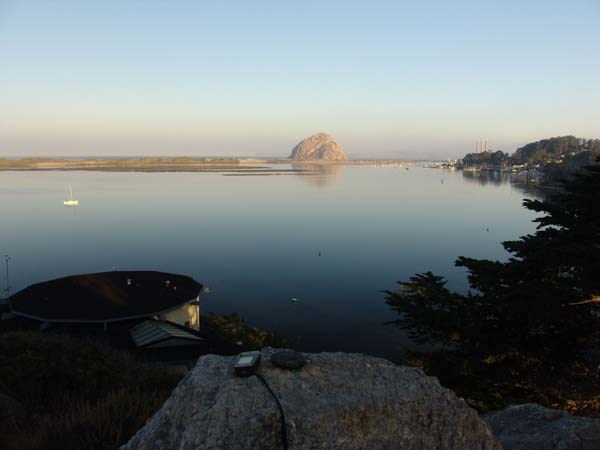
 I'd never seen disks like that. I've seen them scraped up, worn up, and in otherwise bad condition, but nothing ever like this!
Help, I am in Germany and my GPS is not Working!
in GPS technology and devices
Posted
Or........it could be broken.
I experienced the same thing with my eTrex Vista a few years ago while on vacation in Moab, UT. One day the GPSr was working and the next time I turned it on it never found a satellite. When I got home, I contacted Garmin and they told me to send it in for repair.
Hopefully, you just need to let it search a little while longer. Good luck!