


Hank30721
-
Posts
84 -
Joined
-
Last visited
Posts posted by Hank30721
-
-
Bueller....Bueller?
C'mon Groundspeak - give us a good word here!
To follow the bug posting procedures:
I have duplicated the scenario (no My Topo selection under Leaflet Maps) on three different devices:
1)Windows 7 PC running Firefox 12.0
2)Windows XP PC running IE 8
3)Apple iPad II running iOS 5.0
There is not even a selection for My Topo when clicking the map type selection gadget on the upper right portion of the screen.
-
I was sorta hoping it was something on my end! I'm glad it is out for all to see now - maybe some Groundspeak lackies will come to the rescue.
-
Is this a website change or am I having browser issues? Surely My Topo is still a selection!
-
A used, but well taken care of Garmin GPSMAP 76CSx color GPS receiver. This unit has the same CPU and receiver as the legendary GPSMAP 60CSx, but in a FLOATABLE (yes it floats) waterproof design. I am selling this unit with all of the accessories I have purchased for the unit including:
- Original box and packaging, manuals
- Installed ZAGG Invisashield screen protector since device was new - screen in excellent condition
- factory lanyard strap - never attached
- New USB cable
- Used USB cable
- 12v cigarette lighter adapter power cord
- New Trip and Waypoint manager CD
- Used Trip and Waypoint manager CD
- US TOPO 24k East v3 CD - very detailed 24k quad maps of eastern USFS parks with route-able roads
- TOPO 2008 CD - 100k quad maps for the entire US
- City Navigator NT loaded on the device (no CD)
- Lobster Mount UN-198 Device cradle for windshield/hard surface mounting via suction cup
- Gilsson external GPS magnetic mount antenna with suction cup mount for windshield/faring
- 2gb MICRO SD card with most of the above software already loaded in the unit - SD card adapter included
The unit has not been used on a boat, but mostly for in car routing, hiking, and geocaching. It has spent most of its life in a Gilsson full-sheath neoprene case and works great. I will also include the case if I can find it (I have misplaced it since I took the unit out of service a couple of months ago).
See my auction here.
-
-
I am selling my SPOT Satellite Communicator that came with my Delorme PN-60wSE bundle. The unit is just over a year old and has worked great. This unit allows you to send text messages from your PN-60w or PN-60wSE handheld GPS receiver via satellite to a predefined set of cell phones and email addresses. Your GPS coordinates are included with the message including a clickable link to a google map based web browser to see the location in real time. You can also activate a tracking mode that allows your friends and family to track your location on-line via a private web-page - really cool!! All of these neat features are only accessible when paired to the Delorme PN-60w or PN-60wSE.
SPOT will also allow you to make posts to facebook and Twitter, as well as allow you to log your geocache finds on geocaching.com. The satellite service is a once a year fee and works out to about $10-$15 dollars/month depending on your service level.
I have several good pics of the little unit if you're interested.
$100 obo. I'll ship to the US for free if I sell it for $100. Otherwise we can negotiate a very small fee for shipping.
-
I just thought I would follow up here. No luck on getting permission to place the cache. The district ranger in Cleveland TN said she understood the hardship the cost for the application would create but that it was the only way to cover their costs. She said they were being required by Washington to send a specialist to the proposed cache location to ascertain resource impact.
I made the argument that this was not a commercial activity and did not require a special use permit, but she said that any activity that brought people into the forest outside its normal use was special use. I said that these people would be here anyway and just geocache as an additional activity while here. She said that was not what the "geocaching organization" told them.
I said that this basically closed the forest to physical caches - and she gave me a sympathetic yes. Is there any group or individuals smarter than I am that can help pitch in to fight here?? It sounds like we are arguing over semantics.
Let's don't let the Cherokee National Forest be closed to geocaching.....
-
I went and met with the office in question - I took 2 other cachers (one much older, and one much younger and female for a variety - no relation). I made an appt. and told them there would be three of us and that we wanted to discuss cache placement protocol.
When we arrived, the person we were to see took the day off. No one else could help us but to say that all geocaches required special use permits and it would be over a $100. They needed to see the container, which I showed them (micro) and they laughed at why I even needed a permit? I agreed!! They said to come back later when the special permit clerk was back. Another 2 hours of driving wasted.
If I treated an issue at my workplace with that sort of "devil may care" attitude I would be severely punished or dismissed especially with a business partner or vendor.
Is there anyone here who would like to go with me next time or form sort of association to represent us? Is there an association already in place that would be willing to take up some negotiation that I could join?
-
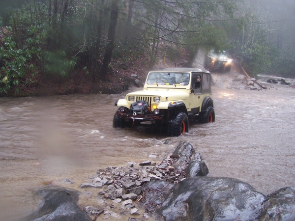
For the easier - more civilized caches :-P, my wife's LJ....
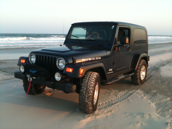
For the more off-road intensive - my 1988 YJ. Modified for occasional off-road use ;-):
-
Some really good ideas here. After some further conversation with the local office, I was even further agitated...see my response to another similar thread:
"I work closely with USFS and NPS employees in my line of work. I understand the issues they face. My concern is that USFS regions run their areas completely different from each other. I have filed permits for placement in NC that were free of charge - very easy process. The supervisor there was a cacher himself. He thought this was a great way to get more people out in the forest to enjoy "their" forest.
In TN, I was quoted $112 to place A cache. That permit would need to be reapplied for each year for $112. I was told at the particular district office that geocaching was not a legitimate use of the forest along with rock-climbing, telescope use, orienteering, etc. He said they were working to keep as many people out of the forest as they could to make resource management easier. He said they were making great strides with motorized vehicle prohibition and equestrian use and now this was another issue they had to manage. He was very bitter and defensive - all I did was ask what was the authorization process....
I understand resource constraints and users that are less respectful of the land than they should be, but this isn't 3rd grade where we all have to stay after class because one idiot was chewing gum when he wasn't supposed to. Don't treat us like sheep. The national forests are there for public recreation - they should be managed to that end. I make compromises every day to live and work to not unduly infringe on my fellow man, forest management should take that same approach. Define cache placement specifically, determine what the appropriate punishment is for violating that policy and carry out discipline to those that violate.
I feel like the USDA is using logic again that they used in removing trash cans from certain areas in the forest - that way people wouldn't pollute?!!"
-
I work closely with USFS and NPS employees in my line of work. I understand the issues they face. My concern is that USFS regions run their areas completely different from each other. I have filed permits for placement in NC that were free of charge - very easy process. The supervisor there was a cacher himself. He thought this was a great way to get more people out in the forest to enjoy "their" forest.
In TN, I was quoted $112 to place A cache. That permit would need to be reapplied for each year for $112. I was told at the particular district office that geocaching was not a legitimate use of the forest along with rock-climbing, telescope use, orienteering, etc. He said they were working to keep as many people out of the forest as they could to make resource management easier. He said they were making great strides with motorized vehicle prohibition and equestrian use and now this was another issue they had to manage. He was very bitter and defensive - all I did was ask what was the authorization process....
I understand resource constraints and users that are less respectful of the land than they should be, but this isn't 3rd grade where we all have to stay after class because one idiot was chewing gum when he wasn't supposed to. Don't treat us like sheep. The national forests are there for public recreation - they should be managed to that end. I make compromises every day to live and work to not unduly infringe on my fellow man, forest management should take that same approach. Define cache placement specifically, determine what the appropriate punishment is for violating that policy and carry out discipline to those that violate.
I feel like the USDA is using logic again that they used in removing trash cans from certain areas in the forest - that way people wouldn't pollute?!!
-
I was informed today by a volunteer geocache approver that hides in the Cherokee National Forest have to be approved much in the same as they do in North Carolina in the Nantahala NF. The difference is there is a processing fee - I was quoted $112 from the district ranger's office to fill out the requisite paperwork, etc. The permit is good for one year and must be renewed each year for the same fee.
This is outrageous!! Is there something going on in the background I'm not aware of that has placed geocaching in the same situation as people building roads and other construction in the forest?
I placed a cache in the same forest a couple of months ago with no issue.
-
-
Just to add to what's been said: The first page you see when selecting the cache will just show coords, D/T. etc. as you described. You can bring up the menu options as ocm_ott described to see the other info or you can go ahead and route to the cache and then while navigating, hit menu again and have the option of seeing all the info.
Hey guys thankj you found the hint and all that just was not taking the next step, now if I can pair my Spot I'll be fine GGRRRRR
Scubasonic
Have you been using your SPOT??
-
I just noticed that easterly bound WAAS 48, has almost caught up with 51.
48 is at 107.94
51 is at 107.27
It looks like that 48 will track just south of 51 as it passes it. (if - means south)
Can't blame my 60CSx for using 46 for the last few says, as 48 and 51 duke it out.
So long 48, and thanks for all the fish....
-
Do not taunt chirp!!!! HHAHAHAHA. What a great SNL commercial!!!! The Happy Fun Ball!
-
Haven't had an opportunity to utilize gps since downloading all the new firmware and Cr 2...and not having any luck getting caches to gpsr. Anyone got a step x step how to??
Head over to the Delorme forums and there are many folks who can help you out. I'm not very handy with CR 2, I just load PQ's via TopoNA.
-
Back to the OP's comment...In my very unsophisticated opinion, the chirp might actually reach fad status for a short period. However, most GPS users - even cachers probably don't run out and buy the latest device offered by any manufacturer, for they usually stick with what works/what is dependable.
There will be many 60(Csx),76(Csx), PN-20,30,40, etc users that will have to have their GPS'r pried from their cold dead hands.
If there are chirp only caches, I'll be left out as will many others. I haven't gone diving for caches nor walked more than 6 miles to retrieve a cache neither. The sport will continue either way - and that's a great thing!!
-
You'd see it as #48, not #133. As it drifts further east, it will actually be a good one for you. I look forward to it moving more to about 104 degrees so it won't be shadowed when I'm up close to the Rockies on the Front Range.I haven't seen it on any of my GPSr's. It has caused more trouble with CATV head-end reception issues than it is worth!!!! I wish I could shoot it down!!
Actually it shows up as WAAS 135. Delorme's PN series do not use the SV numbers like Garmin.
-
For all the Delorme PN owners out there that have heard some of us praise the performance of the "CabBat", I thought I'd mention that it is once again available. Here is the link.
The price has gone up but I think it's still worth it. It gets similar run times to Energizer non-rechargeable lithiums but can be recharged while in your PN. That means far less back cover removals and compass calibrations.
Just in case anyone is wondering, I have no connection whatsoever to the makers of the CabBat, I'm just a satisfied customer.
Better get your order in quick - I understand they go fast!!!
-
I found a well priced pn-60 and it has great reviews apparently,
Shop around. Cabelas, Bass Pro Shop, The GPS Store, Tiger GPS, Amazon, REI, Sportsmans Warehouse, etc.
There are some cool videos showing some PN-60's in action on Delorme's website...www.delorme.com
-
Good good is it very accurate though
I have several GPSr's that perform quite well including the Garmin 60/76Csx. It performs as well or better than those. As the Garmin units have, the Delorme PN-60 uses Wide Area Augmentation System (WAAS) to improve accuracy. It also has a proprietary filter to improve interpretation of satellite data.
-
What Gps's accept pocket queries and allow you to run paperless geocaching, but is still good under trees and finds satellites fast
I have a Delorme PN-60. It does paperless caching really well - holding, hints, logs, etc. It acquires satellites usually in less than 10secs. As far as working well under trees, it has never lost reception or had any weird behavior (that I didn't cause
 ).
).It comes with a a powerful map package including topographic maps of North America. It's great for hiking also!
-
Please explain how jumping through these hoops is going to prevent a lawsuit.
I'm sure that 'lawsuit mitigation' is the official reason.
I'm sure that 'bureaucrat self-justification' is the real reason.

I've read this thread and can't believe the roadblocks the local gov't put up.
What's the famous quote...."I am from the government, and I am here to help."
My Topo is no longer an option under Leaflet maps
in Website
Posted
Thanks for the update Jon!!! Please keep us posted!!