


JBAndersen
-
Posts
27 -
Joined
-
Last visited
Posts posted by JBAndersen
-
-
FHWA- Federal Highways Works Administration. Once called Bureau of Public Roads (BPR), an agency tasked with engineering and building roads in national parks.
-
Hi.
Excuse me, but I can't help myself from jumping into this thread.
My one experience with MORC benchmarks was in North Dakota.
It was a very easy find. Just drove up to it. None of the drama that you experienced in the Missouri Breaks. It was found during a visit to in-laws, I'm not familiar with the area at all. I have no clue how it got its name. Google Maps shows no landmarks nearby with that name. Possibly a landowner at the time?
One more thing. The Yellowstone River was also used for steamboat travel also. Most notably was the Far West, which brought the news of the Little Big Horn Battle back east, in 1876. The Snowden Lift Bridge you mentioned has a companion on the Yellowstone.
Interestingly, the Fairview Bridge has an accompanying tunnel. A railroad tunnel in North Dakota?
Yes. Like you said, fascinating history!
Thanks for your posts from Montana. It brings back fond memories of time I spent there 30 years ago.
(I remember a chili dinner one night at the Winnifred bar)
(maybe it was hunter's stew)
jb
-
Thank you, TillaMurphs and Foxtrot Xray for your nice comments. Being able to add some action to a photo of such a static object as a benchmark was fun.
TillaMurphs, I think I would trade a shot of a choo choo for some nice Oregon Coast scenery, any day. I'm envious.
Foxtrot Xray, I think the Supreme Court disk you asked about is GN0004
That would be quite a find. There's a lot of reasons to visit that area. It's the site of an old section gang house on the RR and from the right angle you can get a view of three levels of RR track. But the road got too rough for my 2WD and I decided that my hunt will involve hiking in. About a one mile level hike by my reckoning. Something for the future.
Once again, Thanks for the validation.
jb
-
I went prowling along the New Mexico/Colorado border on Friday. Driving along Forest Service roads, crossing from Rio Grande National Forest in Colorado to Carson National Forest in New Mexico. And back again. If this is starting to sound familiar, there was quite a discussion about this area awhile back, here:
http://forums.Groundspeak.com/GC/index.php...c=81305&hl=[/url]
I went searching for GN0007
It wasn't much of a search, I pulled out my PDA and used Pocket Topo! to find the X and BM that NGS puts on the quadrangles to show benchmarks. Picked the coordinates and walked right to it.
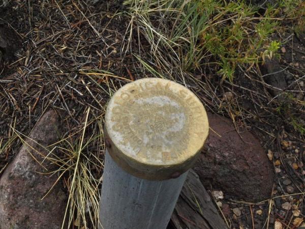
Kind of unusual in that it is a brass cap mounted on top of a galvanized pipe, much like Cadastral marks.
Then I played out a triple play, a hat trick, if you will by indulging three of my interests in one moment.
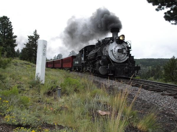
I combined photography, benchmark hunting and Choo Choo Train chasing in one brief moment. This is the daily westbound tourist train running from Antonito, Colorado to Chama, New Mexico of the Cumbres and Toltec Scenic Rail Road running on the old Denver and Rio Grande tracks. The white post with the number 305 on it is mile marker 305. The Denver and Rio Grande originated in Denver and this spot marks 305 miles from Denver along the old railroad system.
Later on, I caught the eastbound train at
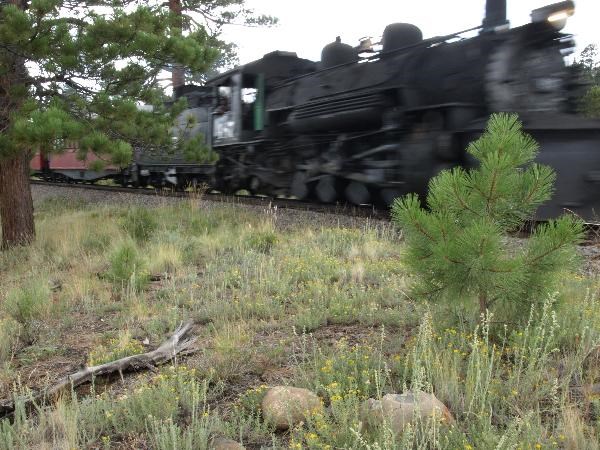
All in all, a good day.
-
I think you've found the hidden treasure!

I'd keep it quiet if I was you.

jb
-
[1) I was in a really remote area looking for a disc (which I didn't find yet) and was at a disadvantage because I didn't have anyone with me who could help pull a tape - but.... I did find orange and blue ribbon - tied together - and tied to a tree branch. Question: What am I to make of that? What do the different colors (or combos) signify?]
Finding two flagging colors in combination would be very tantalizing to me. Surveyors like to use two colors (to separate them from casual flagging users, like realtors, contractors, foresters, etc.) if you are in a certain area for awhile, you learn which surveyors use which color combinations. The colors are chosen for their visibility. Orange and blue would be common. So is pink and blue. Unfortunately, pink and pukey green is becoming more common. It's very much like dogs marking their territory, or street gangs spraying graffiti. It's a way for a surveyor to say, "I was here". And, usually, it means the surveyor found something. Something, for which they are proud enough to hang flagging which says, "I found it!". So, I would keep searching that area, because there's a good chance a surveyor has used the disk within the life span of the flagging hanging from the tree.
The flagging would be as close to the benchmark as possible. If there is flagging in more than one location, try to put yourself in the center of those locations. That would be where the benchmark is. If only one spot of flagging, check the knot used to tie the flagging. The direction from which the knot was tied would be the direction in which the disk is located.
-
I've really been enjoying this thread and the media frenzy that has arisen around this subject.
I just had to, I repeat, had to add this item to this thread.
jbandersen
-
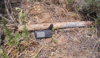
I found this laying on the ground

while looking for
I would like to offer it as an unusual USC&GS benchmark.
It is stamped with "USC&G" and "B.M."
At the time I thought I had found what remained of GM0809 the pipe was laying on the ground a hundred feet away from the search point

I left it leaning against a fence. The mark itself was real basic, 1-1/2 inch pipe, the thin disk was only 1 inch in diameter. Looked like a cost saving effort by the USC&GS.
I haven't seen anything like it.
JBAndersen
-
That's a reference point to a control point on the highway. There should be a second directly on the opposite side of the highway. The mid point of a line stretched between the two would give you the point on the centerline of the highway.
Point of Tangency (PT) 119996.94 feet from the beginning of the highway project.
Federal Highway Works Administration was the agency responsible for road construction inside National Park, National Forests, reservations, etc.
Hope this helps
JBAndersen
-
"Drunken Surveyor". Kind of a double redundancy.
jbandersen
-
Me & Bucky said
playing with hummingbirds in Lake Roberts, New MexicoHey, me too! See ya there, eh?
I can't wait to see how they get those hyper hummingbirds to sit
still long enough to put a band on them.
-
My thoughts, so far, on this thread.
I'm not catching onto the lexical, rhetorical, faux pas, split infinitive
quiz at all, but here's my attempt at deduction.
As per photo (D)
"THE DIRECTOR" is stamped into the disk
at the factory! Pretty serious ego there,
if you ask me.
Which director, though?Spielberg?, Scorsese? J. Edgar Hoover?
The surveyor who mask taped the disk so yellow paint wouldn't
spray onto the brass disk is a perfectionist!
The surveyor who gives elevations to the nearest foot
"ABOVE SEA" is giving results "good enough for government work".
The surveyor who sprayed green paint is near sighted.
I'll have to study the photos some more before I deduce anymore.
Anyway, off to work.
jbandersen
-
Was looking forward to finding GM0809
it was, after all something I had never seen or heard about before, a small disk pinned into the end of a pipe!
And, there it was, laying on the ground right in front of me, about a hundred feet from where my GPSr was telling me to look for it.
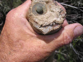
Anybody seen anything like this before? On the disk is stamped "USC&G" on the top and "B.M." on the bottom. Very official looking, but not what you usually expect from the Coast and Geodetic Survey. Some kind of temporary benchmark, or something? Any ideas?
I logged it as destroyed, even though it was very intact, just a bit out of position.
jb
-
Evenfall asked;
About GS0908 DAYTON HARRIS GRAVE MON: Text from GS0206
THE DAYTON-HARRIS GRAVE MONUMENT IS A RECTANGULAR CAIRN WITH A 5X6 FOOT BASE. IT IS ABOUT 6 FEET HIGH. ON THE WEST SIDE OF THE CAIRN THERE IS A BRONZE PLAQUE DEDICATED TO THE TWO PIONEERS BURIED AT ITS BASE. THE POINT INTERSECTED ON THE CAIRN WAS THE CENTER OF A 1X4 THAT IS APPARENTLY THE TOP AND CENTER OF THE CAIRN.
Was this Cairn still extant? It has a recoverable PID...
The DAYTON HARRIS GRAVE MONUMENT is still there. I looked upon it, I read
the inscriptions on the brass plaques, I did not take a photograph, I did not notice the 1 x 4 mentioned in the data sheet, because I did not realize it had a PID till I got home. It's there, it's still intact, but I didn't feel right about claiming a recovery!
Needless to say I did not look for the Azimuth Marker, so I have no idea about it's status.
Death Valley is a gold mine of benchmarks! Along the gravel road on the west side of the main valley (opposite from Bad Water) there must be a benchmark every mile, or less along the 40 mile length. Ready made for someone trying to
set a one day find record. I recovered four of them. None of them were lower than the DAYTON HARRIS gravity station.
As an aside, my attempt to reach the lowest spot in the western hemisphere, -282 ft. (about three miles west of Badwater) was thwarted by water.
jb
-
I hearby submit an argument as to why including the GPSr in the
photo of the brass cap can add to the story.
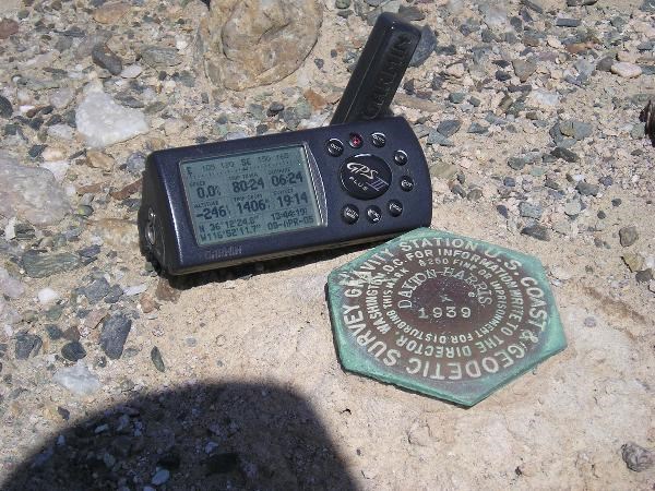
Taken this spring at GS0206
Note the altitude readout on the GPSr.
jb
-
I thought I was pretty familiar with the PLSS as it applies in the midwest, and hadn't run into the term Angle Points. Are these part of an ordinary 8-sided section or do they apply to odder shapes?
In the southwest the PLSS rectangular system runs up against land grants issued by the Spanish empire, and later, the Mexican government. By the terms of the Treaty of Guadalupe Hidalgo, the U.S. government honored these land grants when it took over after the Mexican war. These land grants are described by metes and bounds, rather than rectangular sections, and have rather irregular shapes. The land inside these grants were not surveyed and divided into mile long squares. Monuments were not set at section corners. They were monumented by lines around the outer perimeter. Angle points were numbered consecutively from the point of beginning and sometimes you find mile markers numbered consecutively from the point of beginning, also.
In New Mexico, when we run across a brass cap monument like the one that is the subject of this thread, it means public lands on the the side of the marks showing section, township and range (hence PLSS system) and land grant on the other side of the long marks (hence metes and bounds). The section lines stop at this point. A look at a USGS quad will show the nice, neat reddish lines showing the sections will stop and a void will be on the other side.
The longer lines stamped into this brass cap show, roughly the outline of the metes and bounds survey in that area. Sometimes the initials of the land grant are stamped onto the brasscap.
I think this thread appeals to the investigative nature of benchmark hunting. A look at quad maps in that area might show the irregular shape of the metes and bounds survey, and angle point #5 would be plainly shown.
Whew. I'm out of breath with all of this typing. Hope it helps some.
-
Wow! The Chile Line lives on! It's somewhat amazing; as a youngster interested in model trains, I heard about weird people who were fascinated by this little abandoned railroad somewhere out west called the Chile Line. Now I are one!
Since I've lived in northern New Mexico, I've made it a pastime to investigate and follow the old road bed.
As a surveyor I am also fascinated by benchmarks. When it came time to place a geocache, I of course, placed it along the Chile Line, using benchmarks as references you had to locate, to find the geocache.
In preparing for the cache, my main reference was the U.S. Forest Service map of the Carson National Forest, which shows, as a dotted line, the roadbed of the Chile Line. USGS quads also reference the old relic.
What I have found is that USC&GS or NGS placed benchmarks in a string, every two miles along the road bed. In the area of my geocache there are three. "S30"
"T30"GM0394 and "U30"GM0395. You are right, you can drive right up to them, while driving along the railroad bed. Once, I located one, I just put my GPS in "Go To" mode and drove till I was two miles from the last locate and started looking.
The "30" series of benchmarks goes up in letters as it goes north. When the letters reach Z, the series starts over with "A" but another number is used, right off the top of my head I don't remember which number.
Since the interest in this subject continues I'll keep posting and after the first of the year, I'll get involved in the get-together.
jba
-
Here's some fodder that may help keep this thread going strong.
Bill93 said: I looked up the NM-CO cases in the supreme court, 267 US 30 and 268 US 108, and neither of them had the surveyor's notes from the retracement. Basically the bound volumes had the same thing you can get on line. I had some hopes of more detail because my 1852 volume with the Iowa vs Missouri case did include the retracement notes.William McComber, a Colorado surveyor wrote an article for "Side Shots", a newsletter for Colorado surveyors, about this subject. Unfortunately the article is not online. Here's an excerpt that applies to the missing field notes.
In the Decree entered April 13, 1925, Arthur D. Kidder, cadastral engineer, was designated as a commissioner to run, locate and mark the boundary between the two States. All field work was done under the supervision of Mr. Kidder but was not completed until September 11, 1950. (Mr. Kidder died suddenly at his home in Terre Haute, Indiana, in June, 1958.) There was a delay in the preparation of the field notes and final report due to lack of funds.On July 2, 1958, The Supreme Court of the United States appointed Joseph C. Thoma, of Washington, D.C., Boundary Commissioner, to complete the report and field notes of the boundary survey. The reports, in three sections, were submitted and in its October, 1960, term the Supreme Court Per Curiam New Mexico v. Colorado, 364 U.S. 296:
I've tried searching court records using this information but have not come up with
anything yet. Anyone want to help?
jbandersen
-
Bill, Geo, et al
I found some of the other CO-NM markers in the data base and plotted stated distance versus longitude. There is a tendancy to run to larger stated distances, relative to longitude, in the middle of the line than nearer either end.There is something strange to the tune of 2 1/2 miles somewhere in the first 19 miles of the line, that may account for most of the difference we see between stated length and length from coordinates. A closer re-reading of the history might explain that? Did they really begin at 0?
Sometimes a picture is really worth a thousand words. A close up of the NGS topos
on Topozone, etc. near the New Mexico, Colorado and Oklahoma corner shows the "Macomb Monument" to be two and a half miles west of the "Preston Monument" which is OK CO NM COR RESET.
The "Macomb Monument" is mile zero in the stationing schema that has drawn so much attention here. 163 + 22 CHS that Colorado Papa found should be 163+ miles west of the "Macomb Monument", not the "Preson Monument" which is the tri-state corner. There are two sets of mile marker nos 1 & 2. One set going west from the "Macomb Monument", another going west.
I hope this adds more fuel to this discussion. I wish I knew how to add links to this post, then I would have added the links to the benchmarks, instead of relying on my memory. Please have patience for this forum newbie. g'day.
-
more two cents worth
The dismantled railroad is that of the Santa Fe branch of the Denver and Rio Grande Western narrow gauge, known as the Chile Line. It was dismantled in
1941. In 1933 it appears Hwy 285 did not exist yet and the railroad was the transportation corridor in this neck of the woods. NGS (USCGS?) placed benchmarks every two miles along the old railroad bed. A lot of these are still in place. I have a feeling that the Supreme Court monument was placed out of the normal mile interval to place it close to the old right-of-way, for a reason. Maybe to be useable in the chain of vertical control points NGS was placing. (purely speculation on my part)
For those benchmark hunters who are not too turned off by standard geocaches
check out
http://www.geocaching.com/seek/cache_detai...7b-74e43c442466
I integrated benchmark hunting into a geocache. As well as railroad history.
Cheers!
-
I hope it's not too presumptious of me to jump into the middle of this
thread, but I have some personal knowledge of those particular benchmarks.
A boundary dispute between New Mexico and Colorado had to be settled by a
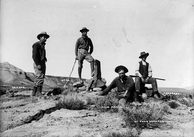
Supreme Court decision, sometime in the 1920s. The final location of the boundary was marked by serious monuments, looking very similar to NGS benchmarks, placed every mile starting in the east and going west to the Four Corners Monument. You were looking for the 163rd one from the Oklahoma, or
Texas (I don't have my atlas handy) line.
I've seen the one you were looking for, it's very distinctive. It's about a hundred feet east of the old railroad bed. Its stamped "U.S. Supreme Court" Date of the court decision. "New Mexico" "Colorado" Mile Marker
Number. It's coincidence that NGS has included this one in their database. There
are three hundred or more of them along the boundary. Looking for them is fairly simple, follow the fence east or west.
Interestingly enough, the boundary does not perfectly follow the latitude assigned, but west of Chama, near Monero, it takes a jog to the north for about three hundred yards, then continues west.
-
Anybody notice the prescence of stealth cachers in their caches? Like, someone who makes no entry in either the logbook or the web page, but leaves a signature item in the cache to mark their visit?
I suspect this type of activity at one of my caches and wonder if anyone else has noticed this?
Is this type of activity ethical? Moral? Could it possibly be condoned?
Let's hear it.
jbandersen
[This message was edited by JBAndersen on May 06, 2003 at 09:34 PM.]
-
Thanks RDW! Not only did I find what I was looking for, I've improved my Google skills. Thanks again for the tip. jba
-
Thanks RDW! Not only did I find what I was looking for, I've improved my Google skills. Thanks again for the tip. jba

Unusual disk
in Benchmarking
Posted