


Kai Team
-
Posts
1028 -
Joined
-
Last visited
Posts posted by Kai Team
-
-
If you want a table in your logs, use the GSAK CopyFilterToLog macro. The output is very flexible and should satisfy both OCD cache finders and cache owners (since it is text that can be copied)!


-
 2
2
-
-
I'd be happy if the PQ's were just updated to include all of the information returned by the API - e.g. corrected coordinates, with an indicator, original coordinates, favorite points.... It would reduce the demand on the Groundspeak servers, since users would not have to update caches with the API to get missing information after loading PQ's. Enhanced PQ generation search criteria would be the icing on the cake, but first we need the cake (complete cache information in the PQ's).
-
.png) 4
4
-
-
It appears the problem with rendering Markdown on the first line of a log has been fixed! Kudos to Groundspeak for a quick fix!
 Applying Bullet formatting to the block brings the font back to normal output. Just an observation.
This is how preformatted code blocks work in Markdown - i.e. everything within a preformatted code block is interpreted literally - i.e. you cannot "nest" Markdown within a preformatted code block as you could with BBCode, and if you try, it will either be rendered literally or it will terminate the preformatted code block, depending on what you are trying to nest.
That's why it would be nice to have tables in the Geocaching.com implementation of Markdown - AFAIK, you can use other Markdown (e.g. emphasis, links) within a Markdown table, so we would be able to duplicate what we used to be able to do in BBCode Code blocks. I'm hoping that Markdown tables may be on the list once the initial implementation of Markdown settles down.

-
Yes, it is the loss of spacing when the Code Block is the first line of the log that I am referring to. Thanks for following up.

-
It's not one of Markdown widgets being offered.
The Markdown offered is bold, italic, a unique Quote function, link, horizontal line, 3 Headers, numbered and bullet point lists.
I'm not sure where you got your list, but my understanding is that it is supported - Groundspeak said that they are supporting Markdown as described by the "How to Format" link on this page, with some exceptions (e.g. they are not supporting things under Extra Mode). Preformatted code block is not one of the exceptions mentioned by Groundspeak. BTW, I'm using 4 spaces, not a tab, but it sounds like either will work, since you are sometimes seeing font changes following a tab. I suspect it is sometimes because of the issue I reported above - it only works if there is a line of text and a blank line before the line with four spaces or a tab.
-
Two bugs actually:
1) The Preformatted Code Block does not work unless the code block is preceded by a line of text and a blank line (in other words, you cannot start a log with a preformatted code block, as when logging something where you want columns of information aligned.
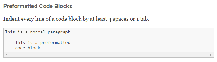
Since the Geocaching.com implementation of Markdown does not permit tables, this is the only way to present, for example, a formatted list of caches in a log.
2) If a log is edited to change the Markdown, the changes are not rendered when the edited log is posted (I discovered this testing for the above bug, and assume it may apply to other or all edited logs).
Thanks for addressing this.
-
OK - thanks, doing a GPX for each would be very time consuming, and as a Mac user GSAK isn't an option.
You can run GSAK on a Mac. Best results are with Parelells, but others do it in other ways. There's a GSAK forum for discussing using GSAK on a Mac.
Edit:silly typo
-
Great to hear that this is under consideration.
Based on my experience in the GSAK forums, the following items not available in current GPX downloadable files (cache page or Pocket Queries) are missed/requested/discussed the most by GSAK users:Corrected coordinates (w/flag)
Favorite points
Personal cache note
Image links
Cache finds for previous finders (assuming this means the number of finds, similar to what is shown on the cache page below the log owner's avatar next to their log).
I'd also ask that you create and maintain consistency between the data delivered in the new format downloadable files and the data delivered by the SearchForGeocaches and GetMoreGeocaches API calls. Inconsistencies in the data delivered by the two methods create a great deal of confusion and leads to increased demand on the Groundspeak servers (e.g. caches are obtained via Pocket Query or cache page download, then have to be refreshed using the API just to update Favorite Points).
Another useful bit of information would be the total number of logged visits, as shown on the cache page. Like consistency in data between methods, this would decrease the demand on the Groundspeak servers (e.g. knowing the total number of logs would allow a user to get a "Published" log for challenges without having to download all of the logs on the cache).
Thanks for your consideration.
-
Now GPSCity is showing May 6. Although Garmin has screwed up the launch, one can hope that the firmware will be less buggy than most of the newer Garmin GPSr's have been when it is finally released (i.e. fewer firmware updates in the first year of the unit's life).
-
In response to a user request, I couldn't find the macro referenced above, so I've written one. The advantage compared to fetching caches from a filter, as suggested by The Jester, is that this macro will pull all of the old log information, including log date, time, type and text, from a GSAK database and allow you to use GSAK V8's (Geocaching.com's API) Publish Logs feature to easily re-log with the original date, time, etc. You can find the macro here.
-
Can disabled caches and archived caches get included in pocket queries. This way I can keep GSAK up to date. Happened twice today I hit ground zero looking for a cache with my gpsmap looked around then checked the cache status on my phone to find out it had been disabled or archived.

FYI, this request has been made many times and has thus far not been fulfilled by Groundspeak. However, many GSAK users have developed workarounds for the fact that archived caches are missing from the Pocket Queries (temp disabled caches are included in Pocket Queries and their status in GSAK will be updated when you load the GPX file). Click here for an old post in these forums that outlines the basic idea. Click here to visit the GSAK forums where you can search for other methods, find automated macros that make things easier, and ask questions of experienced users.
-
Keystone,
Re: this post, I cannot find anything in the GSAK help file that tells users to make a post here to obtain their Owner ID number. Do you know if or where this is stated in the GSAK help file? This page of the GSAK help file does need to be updated to reference the geocaching.com account details, but it does not instruct users to make a post here.
-
Does any GPSr strip out the HTML or actually render it properly? I kind of made this sugestion based on the assumption that this would be rare... if it's just the Triton who does it badly, then never mind then.
Yes, the Garmin Colorado and Oregon do a decent job rendering basic HTML (i.e. that you find on most cache pages).
As far as stripping out the HTML before sending it to your Triton, that could be done with GSAK (click here) and a simple macro. In fact, this thread prompted a GSAK macro that strips the HTML out of a GPX file (click here). You could use GSAK to strip HTML from your GPX files before loading them to the Triton using VantagePoint.
-
DIV tag rollback has been applied and is working...
-Raine
Thank you! Working well again!
-
I always assumed that posting to this thread was effectively adding your name to the list because then you would (by default) get notified of anything they announce here.
This thread is the list and the announcements.
I'm not sure what everyone means by "adding names to a list" (this or other ones). Click on "Options" in the upper right corner of the page (scroll up to the top first), then click on "Track this Topic". Then you'll get notifications when new posts are added to this topic, including those of people asking to have their names added to the list.
-
...
I have the Garmin 60CS and I use GSAK to send the gc waypoint code (dropping the redundant "GC"), the container, the difficulty and the terrain (%drop2 %con1%dif=1%ter=1 in GSAK) as the 10 character waypoint name, and the cache name as the "waypoint description" (this shows up in the "comments" on the 60C/S and can contain up to 30 characters).
...
where does one find the syntax that can be used? The %dif=1 is a bit obscure as is the %drop2
TIA,
Jim
In GSAK, go to Help>Contents>Miscellaneous Features>Special Tags for a list of all available special tags and their definitions. Immediately below the list of special tags you will find:
Note: The tags %name, %by, %con, %typ, %smart, %hint, %crypt, %user, %dif, %ter also support the format %tag=nn. Where nn is the number of characters to include. For example %typ=3 would only include the first 3 characters of the cache type, so that a "Multi Cache" would be translated to "Mul" -
This unit was sold and is no longer available.
-
Sorry - I thought I'd tracked this thread so that I'd be notified of replies (apparently not
 ). The unit was sold - it's no longer available.
 FYI:
Does this have a spot for an SDcard? Also, the maps cd's. I know, silly question. But are there maps already on the unit or must you have the cd's and updates. Sorry, new cacher.No - the original eTrex Vista does not have SD card capability. The eTrex Vista Cx does.
With the original Vista, the unit somes with "base maps", which show major highways, etc. You can download detailed maps to the unit's internal memory, up to the 24 MB capacity (which is a very reasonable sized area in most cases).
-
...how many GPSr's does one person need?

Garmin Etrex Vista hand held GPSr with all accessories
Asking $150 for the package. Well cared for, unit and screen are free of scratches. Unit is fully functional.
Accessories (accessories alone are a $150 value, not including mapping software):
* PC serial interface cable (click here for more information)
* Garmin Hard Case holster with belt clip (click here) (this is why the unit is in such good condition!)
* Garmin neoprene soft carry case with view window and belt clip (click here)
* 12V DC power cable for use in car (click here)
* Garmin car windshield suction cup mount/cradle (click here)
* Garmin Trip and Waypoint Manager (click here)
* eTrex Vista Owner's Manual
* Garmin MapSource MetroGuide USA (V 5) Map Software**
* Garmin Waterways and Lights (US) (V 3.01) Map Software**
eTrex Vista Product Information (from the Garmin Website):
The eTrex Vista® combines a basemap of North and South America, with a barometric altimeter and electronic compass. The compass provides bearing information while you're standing still and the altimeter determines your precise altitude. The Vista is also designed to provide precise GPS positioning using correction data obtained from the Wide Area Augmentation System (WAAS). This product will provide position accuracy to less than three meters when receiving WAAS corrections.
The eTrex Vista also boasts an internal memory capacity of 24 megabytes, which allows it to accept downloaded mapping data from Garmin's MapSource® CD-ROMs, including U.S. Recreational Lakes with Fishing Hot Spots. A silver case gives this unit a high-tech look. New to the product design, Garmin will include marine aids to navigation in addition to the basemap. These navigational aids will be pre-loaded into each unit from the factory. Garmin part number: 010-00243-00
Actual Picture of all items for sale:

Contact Kai <dot> Team <at> gmail <dot> com or through my profile on this website.
**Note: these detailed maps cover the entire USA and are from 2003. Because updates are no longer available from Garmin (they've gone to a new map series), and they are offered "as is" (they should work for you, but I can't guarantee it).
-
Garmin Etrex Vista hand held GPSr with all accessories
Asking $190 for the package. Well cared for, unit and screen are free of scratches. Unit is fully functional.
Accessories ($150 value, not including mapping software):
* eTrex Vista Owner's Manual
* PC serial interface cable (click here for more information)
* Garmin Hard Case holster with belt clip (click here)
* Garmin neoprene soft carry case with view window and belt clip (click here)
* 12V DC power cable for use in car (click here)
* Garmin car windshield suction cup mount/cradle (click here)
* Garmin Trip and Waypoint Manager (click here)
* Garmin MapSource MetroGuide USA (V 5) Map Software**
* Garmin Waterways and Lights (US) (V 3.01) Map Software**
**Note: these detailed maps cover the entire USA and are from 2003. Updates are no longer available from Garmin (they've gone to a new map series), and they are therefore sold "as is".
eTrex Vista Product Information (from the Garmin Website):
The eTrex Vista® combines a basemap of North and South America, with a barometric altimeter and electronic compass. The compass provides bearing information while you're standing still and the altimeter determines your precise altitude. The Vista is also designed to provide precise GPS positioning using correction data obtained from the Wide Area Augmentation System (WAAS). This product will provide position accuracy to less than three meters when receiving WAAS corrections.
The eTrex Vista also boasts an internal memory capacity of 24 megabytes, which allows it to accept downloaded mapping data from Garmin's MapSource® CD-ROMs, including U.S. Recreational Lakes with Fishing Hot Spots. A silver case gives this unit a high-tech look. New to the product design, Garmin will include marine aids to navigation in addition to the basemap. These navigational aids will be pre-loaded into each unit from the factory. Garmin part number: 010-00243-00
Actual Picture of all items for sale:
Contact Kai <dot> Team <at> gmail <dot> com or through my profile on this website.
-
Good point. It would also cut down demand for PQ's if there was some indication of when a cache is archived in the PQ GPX file. Otherwise you're left with the need to infer archived status from the cache's absence in the PQ file, which leads to greater demand for PQ's.
-
2) there's no way to receive just updated caches (i.e. with new logs, TB's or changed status or descriptions) - you have to get them all. In most of my PQ's (which I run once a week), over half the caches have not changed since the last PQ.
What's wrong with the option "Updated in the last 7 days"? Works well for me.
Nothing, unless more than 5 logs were written since your last update, which brings us back to point #1 (only the last 5 logs included in the PQ). My two points are interrelated - i.e., people would run a lot fewer PQ's if there was a way to insure that they would get a complete set of logs (nothing like getting into the field and discovering that the one log you don't have is the one with corrected coordinates).
Perhaps allowing people to choose "Updated in the last 7 days" and that choice includes all logs for the period of time chosen (7 or 14 days).
-
They tell me I can have 35 a week so from now on I will run 35, I don't need them but i pay for them so 35 it will be. Let the GC boys realise that they are seriously P*****g off people here
If every Premium Member on GC.com thought this way, no one would EVER get a PQ on time!!
Yes, I suspect that's the reason why gc.com is now managing PQ's with a bulldozer - too many premium members do think that way. I doubt many members look for 500 x 5 x 7 = 17,500 caches per week (yes, I know many people run the same PQ multiple times per week to update logs and cache status).
Which brings me to another point - has gc.com stopped to think about why people are running so many PQ's? Part of it is just because they can, but much of it is because of things like:
1) PQ's only contain the last 5 logs, leading people to run them more frequently to keep their offline logs up to date and complete, and
2) there's no way to receive just updated caches (i.e. with new logs, TB's or changed status or descriptions) - you have to get them all. In most of my PQ's (which I run once a week), over half the caches have not changed since the last PQ.
If the PQ's contained more logs, members could drop from running PQ's 3-4 times a week to just 1-2 times a week - instantly halving server load. And if there was a way to get just the updated caches... well, you see the point.
How about considering why people are running so many PQ's and redesigning things to better meet members' needs? Then you could lower the number of PQ's allowed, still meet members' needs, and everyone would be happy! "For every complex problem, there is a simple (and wrong) solution".
-
Hi Bob,
You cynic you! Having said that I have to agree. The whole concept of PQs is automated receipt of data, how they can hide this is beyond me!
(Congrats on your 1000th post btw
 )
)Thanks. What's beyond me is how you can consistently choose to alienate your paying customers when there are other aproaches to accomplish a legitimate goal. I guess it's the Microsoft business model (worked for them).


.png)

 ). The unit was sold - it's no longer available.
 )
)
Are some benchmarks not listed?
in Benchmarking
Posted
I haven't logged a benchmark in a long time but discovcered two on a recent trip to Arizona (see attached photos). According to the exif data on the photos the first one is located at 34.29128 N, 114.11591 W and the second one is at 35.08429 N, 109.78827 W. I went to log these benchmarks but cannot locate them using any of the Geocaching.com search tools or the NGS Benchmark Viewer by ScaredCatFilm. What am I missing?