

DaveD
-
Posts
589 -
Joined
-
Last visited
Everything posted by DaveD
-
The change has nothing to due with any priority that NGS gives to one service or product over another - they simply rearranged them in alphabetical order.
-
USGS is interested in getting recovery reports
DaveD replied to Black Dog Trackers's topic in Benchmarking
Coordinates for 1 mile north are -- 38 22.099 / 81 37.582 Coordinates for 1 mile south are -- 38 20.359 / 81 37.582 Computed using NGS utility FORWARD. -
Many of the very large, concrete targets you see out in the SW used by DoD (and others) to calibrate pictures taken from very high flying aircraft such as the U2 and early space-based observation platforms.
-
-
I checked the datasheet for GP0238 and it shows the updated HH2 position you reported in a 2010 recovery note along with the pictures you took. Typically when HH1 and HH2 positions are submitted via DSWorld they are usually posted to the NGS database within 4-6 weeks. The loading process has a checking routine that flags anything that differs from the scaled value by more than 10 seconds of latitude/longitude. Those submissions must then be hand checked by someone, in most cases while I was still at NGS that was me. While these are typically a small number per month they can take take some time to resolve depending on work loads etc.
-
I have not encountered the problems you've noticed with DSWorld - with this and any suggestions you may have for improvements, drop a note to Malcolm Archer-Shee -- malcolm.archer-shee@noaa.gov. Malcolm is the primary programer for DSWorld and works under contract for NGS. He's a retired land surveyor so he knows the issues with finding and updating passive control information as well as anyone I've known and he's awesome about fixing or adding improvements to the program. As to updates to the NGS database and hence the datasheet. Due to a variety of issues I regret that this is not a straight forward process. If you submit digital pictures they are usually added to the datasheet within 2-3 days. Updating hand-held positions and recovery information can easily take 5-6 weeks. Unfortunately NGS has experienced a number of retirements and is a very small, short staffed organization. Updating and maintaining the primary elements of the National Spatial Reference System such as the CORS, computing geoid models, developing transformation tools, maintaining the database and shoreline survey data tools takes up the vast majority of the agency's resources. I can assure you that they would love to have the ability to make these updates in a more timely fashion -- Maybe someday when they actually get a real budget.
-
Try contacting Ed Carlson the NGS Hawaii State Geodetic Advisor -- ed.carlson@noaa.gov
-
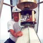
The use of eccentric stations at lighthouses was not at all uncommon. Since these structures often provide excellent visibility over many miles they were excellent locations for geodetic observations without having to build a tall, expensive and temporary observation tower (after 1927 referenced as Bilby Towers). Generally eccentric stations were set where the field team could not easily occupy the primary point such as the finial or peak of a lighthouse. In numerous cases eccentric stations were established a ground level when an existing tradition triangulation station could not be directly occupied for some reason. The eccentric station could be either a temporary point or one that was more permanent such as drill hole or a disk. The field team would perform the direction (angle) observations at the eccentric station and then very accurately measure the distance from the eccentric station to the point they really wanted the coordinates for. Using these data the field computer could perform what was referred to as a reduction to center which is a neat little trick that allows you to modify the observations from the eccentric station to make them look like they were actually observed from the primary point (lighthouse finial etc.). You can find more details on this procedure in USC&GS Special Publication 247 "Manual of Triangulation" on pages 114-115 and 154-157.
-
USGS is interested in getting recovery reports
DaveD replied to Black Dog Trackers's topic in Benchmarking
Meridian marks were set by both USC&GS and USGS. The marks were usually set in pairs a couple of hundred feet apart. In many cases they were set on or near the grounds of a county courthouse. The primary function of these marks was to provide an authoritative location where surveyors could come and compare their compasses against a known magnetic bearing (azimuth). Typically the USC&GS/USGS field team would determine the magnetic bearing between the two monuments then perform an astronomic observation, in most cases a solar (sun shot) to determine the "geodetic" or "true" bearing of the line. Surveyors could then set their compass on one station, backsight the other and determine what, if any offset they needed to apply to their instruments. In some communities it was required that surveyors perform this function annually. These stations also served as reference sites for the determination and monitoring of the change in magnetic variation. For many years USC&GS and USGS produced maps of local and regional magnetic variation. As the use of transits and later theodolites replaced the use of the compass for surveys the need for these stations for that application faded away. Today they are a true relic of surveying history. -
You are right, this is an orphaned mark. Unfortunately from time to time C&GS was forced to suspend work on surveys for a variety of reasons (e.g. budget, changes in priorities etc.) and they were never completed. This didn't happen very often but it did leave behind marks they set but were never able to survey. This specific mark was later positioned as part of a triangulation project by the U.S. Geological Survey (USGS), unfortunately like so much of their work it was never submitted to C&GS/NGS for inclusion into the national reference system.
-
Using benchmarks to test consumer GPS accuracy
DaveD replied to Mapping Support's topic in Benchmarking
Go the NGS web site www.ngs.noaa.gov and select "Survey Mark Datasheets" from the left side of the page, then "DATASHEETS" from the next page. This takes you to the NGS DATASHEET RETRIEVAL PAGE. Once you've determined how you want to retrieve the data on the following page select under Date Type Desired select GPS Sites Only. This will provide you with a listing of the passive control stations with the highest horizontal positional accuracy - in most cases better than 2-3 cm. Also by selecting this option you will be assured of getting a listing of stations that were at least once occupied with geodetic quality GPS and should (I say should) have the fewest obstructions. -
Anyone interested in Clarence King should read "Passing Strange." He led a very interesting and complex life.
-
foxtrot is correct. If the station is an old triangulation station with an underground mark then it's horizontal position is preserved and therefore not destroyed. If's it's strictly a bench mark (vertical control only) then this mark is definitely destroyed.
-
Based on the position you provided it looks like you found RM 2 (DB6972). Using the distance and direction from the main station the position for RM 2 would be 40 02.110/121 43.116
-
What are the odds for finding this one?
DaveD replied to 2oldfarts (the rockhounders)'s topic in Benchmarking
I have submitted county corrections for both marks to the NGS database. They should be posted within a couple of weeks. Thanks for bringing this to our attention. -
Exactly correct - HV8077 (B 8).
-
The "key" you saw in the picture is a special tool we use to remove the threaded cap which covers the actual bench mark which is embedded in the side of the monument. Then we slide a 18" stainless steel pin into the cavity and place the level rod on the pin. Once the measurements are completed we remove the pin and replace the cap so the cavity doesn't get filled with dirt and other debris. Only NGS and the National Park Service have access to these special tools.
-
The mini-Monument was the original bench mark established by Col. Casey of the Army Engineers who was the engineer in charge of the completion of the Monument. He set the mark to monitor settlement of the foundation during the construction. I know the datasheet says 1971 for the first time NGS visited the mark and I've tried for years to correct that. We actually first survey this mark in 1901 and on at least 13 different campaigns since then.
-
I thought some of you might be interested in the on-going geodetic survey of the area around the Washington Monument -- Washington Monument podcast
-
DSWorld is free -- http://www.ngs.noaa.gov/PC_PROD/PARTNERS/index.shtml
-
Thanks "FAN" for giving this a bump. You beat me to it. It must be that good Tiger upbringing. BTW my Dad was a Tiger - he was very disappointed when I chose not to go "home" to go to school.
-
NGS has scheduled a 1-hour webinar on using DSWorld for Thursday, February 16. DSWorld This is a very powerful tool that allows your to display control in the NGS database against a Google Earth background, upload digital images, make corrections to scaled bench mark positions with hand-held GPS values, submit updated recovery information and much more.
-
Thank you for the correction - yes, it see that it gives an error notice. I will check into this when I'm in the office tomorrow.
-
I opened up DSWorld and input DK4651 and it immediately filled in the fields for station WOODY.