

Woof!
-
Posts
202 -
Joined
-
Last visited
Posts posted by Woof!
-
-
I'd prefer a two step process. Swipe is too easy to do accidentally.
Swiping itself is a two step process already.
1. You swipe to bring up the delete button.
2. You press the delete button.
It's hard to do accidentally. I've never deleted an email accidentally using this technique.
-
I download a fresh pocket query for whatever area I'm caching in each time I go out. This is usually at least once per day. Because downloading a new pocket query doesn't overwrite the previous saved list, the user must delete the previous saved list first. (I think this is fundamentally wrong to begin with, but that's a different gripe that has already been shot down and called a "feature") Currently you have to load the saved list you want to delete before you can load it. This is bulky and seems unnecessary. It would be great if you could swipe the list you want to delete (like you do in the iphone email app) from saved lists page to avoid having to load the list just to delete it.
-
I just tried that process and can successfully upload files. How do I get them on my iPhone. This really is a useful feature to have. I notice another App 'Geosphere' has this.
Did you try accessing it the same way you would a pocket query?
Edit: I tried it and the normal route to download a pocket query on the iPhone didn't work for the uploaded file from this page. I guess it is just a forgotten link/page.
-
There is currently a link on the GC.com site to it. I'm returning to geocaching after a very long hiatus so I guess I missed its original coming (and going). The link is on your user profile page, on the right, under Premium Features>Saved GPX Files.
-
I think what you are asking for already exists. I just noticed this myself. Check this out. http://www.geocaching.com/pocket/saved.aspx
You can upload a gpx to your account on geocaching.com, and then access it from your iphone. This way you can manipulate a PQ however you want and then feed it back to the iphone.
Hope this helps!
-
Here's mine.

-
Latest developments: I tried the last image that wasn't working again from home tonight and still got the error. Kablooey suggested that maybe the image was just too big. So, resized it myself and tried again successfuly. The size limit (there isn't one posted on the upload page) has probably been discussed somewhere, so I'll try to find it. If this really was the cause of the problems (it doesn't explain why the others didn't work at first but did later) than maybe the size limit should be on the upload page.
-
The above error is while using Firefox. Internet Explorer goes to Page Not Found.
-
The problem doesn't seem to be related to my files, my computer, or my connection. I repeated my steps with new photos from my work computer and still got the error for 1 out of the three uploads I attempted.
-
I'm beginning to think it's a problem with my files, but I can't imagine what that problem would be. From the same batch of photos - taken and uploaded together - some upload fine, and others still give me this error. Any ideas?
-
Today and yesterday I get the error "The document contains no data." when I attempt to upload the second image to a log. I have tried different images, and different logs, to no avail. Is it a problem with my files or with gc.com?
-
A normal day of hiking is usually around 8-10 tough miles (lots of elevation change). I've made a handful of multi-day backpacking trips, most solo, and often just to get one or two caches. The longest so far was 4 days and about 42+ miles to get first to find on one cache. It rained on me 3 of the 4 days which helped in my decision to cut 4 extra miles I was planning for a second FTF.
This is my favorite way of geocaching; I only wish there were more people placing caches in such out of the way places!
-
After experiencing the "name of cache" cache, take a walk down the main trail ( be Careful) to view Rattle Snake Creek passing under a massive granite cliff and out the other side through the "name of cache". If the weather is nice and warm you might have a picnic lunch with you and you might want to take a dip.Just checked if the cache is still there. YES it is! Weeds have grown up a bit, try a little harder.
-
I'm receiving published logs for my area now. I also had 11 of my own caches approved. I received 22 emails. Is there anyway to put a check in so that you don't receive either the original approval listing or the new published listing for your own cache if the other is already being sent?
-
I'm very excited about the potential of this feature! Something I'd love to see is the option to ge a "short" version of the notify. This would be the one I'd want to send to my phone. It wouldn't need any links or the "This is an automated message..." bit. An example might be:
Subject: [GEO] Notify: New Published
GCKD91 Little Road in Town by rightseatsis
(1/1) Trad/Small
N 37 44.786 W 122 25.693
37m SE
Thanks for the new feature(s)!
-
This, however is counter productive if you are a number puncher type.
You don't have to be a number puncher to want to move fast while out caching. There are different types of caching styles out there, obviously, and my personality happens to put me in the restless category. I just don't like to sit still or wait around when there is something else I'd rather be doing.
I only bring this up because I wanted to illustrate the benefits my method of logging my finds has for me. During my most recent caching trip in Palm Springs, there was almost no need to use my palm. (I don't like cachemate anyway, I use plucker, but that's a whole different thread) Using my palm would have slowed us down. So, the fastest thing to do while out there was to delete the waypoint.
Another benefit for deleting the waypoint is that the screen becomes less and less cluttered with caches the more you find. When you're finding 90+ caches in one day in the same area, it would be very confusing if you kept both the caches you haven't found and found in the gps.
-
-
Right before the first mention of this trip came up in the SF thread, I had my own event planned. I decided to forget that idea since I wanted people to be able to attend both. Anyway, what this means is that in all liklihoods, I'd be free to go to Portland. In fact, it's been my lifelong dream (for about a year
 ) to go.
My internship ends April 20 at which point I'll be moving back to the bay area...hooray! As long as I can find an apartment sometime after that, I would be able to go. I can even drive (I have 4wd) but I much prefer being a passenger.
-
With the recent big changes I'm sure you folks have more on your mind than fixing these kinds of problems, but at the same time, it shouldn't take more than a minute to fix. Actually, I'd be surprised if this hasn't been mentioned already. Pardon me if it has.
In the emails sent out titled "Listing Approved on Geocaching.com", the link to the approved cache doesn't work because there is no leading space before it and the title of the cache.
-
Wouldn't you rather come visit me at Bear Valley!!

-
I didn't sign, because I respect a company's right to decide NOT to give away a service at a loss of revenue if they don't want to. I'll be damned if someone were trying to force my company to lose money, and I'll be damned if I'll try to do it to someone elses. There are other free options to use, like MapPoint, or even better, go out and pay for a mapping solution and then at least you'll have a reason to complain if they take the feature away.
I might add that Mapquest also receives revenues from the ads that appear when you do driving directions, and on other pages in the site. Our traffic to these ads encourages sponsors to want to pay, and pay more, to advertise on the Mapquest site.
I totally support a companies right to do whatever they want, but it's also not unreasonable to make suggestions to a company. After all, "free" service or not, anyone who visits the Mapquest site is still a customer.
This isn't the first time Mapquest has removed usability from the maps linked to from gc.com. They also removed the "big map" option not too long ago. I miss this option, as well as the driving directions. I hope they come back.
-
My preferred icon priority is to display what type of cache it is (traditional, multi, virtual, mystery) and my secondary desire is for traditional micros to be displayed as such.
I'll second that. Being a former Spinner user, I'm used to having the micro icon override all of the cache types. It wasn't a huge problem, but at times it was confusing. If I pull up a waypoint and see a micro icon, I'll start looking for a micro. If the cache is anything but a traditional cache, I'll be out of luck.
Is there anyway to add an option to "override only if traditional" to the micro override?
BTW, I'm just getting the hang of GSAK after registering my really old version yesterday. It took some convincing for me to switch from my spinner/plucker combo, but it's looking like I might just be able to make the switch. So, thanks for all your work!
-
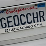
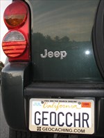
I recently took a Jeep 4x4 picture that I thought would be a great submission for the photo contest.
Link to it?
Sure, though I didn't mean this thread to be about my picture.
-
That reminds me...
I forgot to mention that because my picture was clearly better than the ones that made it in time, because I didn't know that the time period was up, and because the site accepted my photo, I believe I am entitled to a new Jeep.


[Suggestion] Import GPX files
in Website
Posted
I think a much better way would be to add the solved puzzles/multi's to a dedicated Bookmark list, which you can then create a pocket query for. Using your way you're going to be getting lots of emails and your pocket query will include caches you simply wanted on your watchlist.