


JeremyR
-
Posts
491 -
Joined
-
Last visited
Posts posted by JeremyR
-
-
Premium Only caches will display for all users on Beta Maps, with coordinates slightly obscured
How slightly is "slightly"?
The PMO caches I'm looking at on the beta map appear to be showing at their *exact* listed coords when I look at it with both a PM and a non-PM account. (FF4, Win7, hard-refresh done, etc, etc).
It's fairly trivial of course to extract the coords of the map markers with Greasemonkey or something so there's nothing at this point to stop non-PM members finding the precise coords of PMO caches.
-
I think one of the reasons for having everything off in the plane during take off and landing is so that the crew have your full attention. If something happens and they are giving instructions to half the passengers listening to music, then the safety of everyone is compromised.
This is the reason as far as I know. They want you to switch all electronic distractions off at certain times for the same reason that the seat-back entertainment locks up whenever an announcement is made. It's nothing to do with the plane falling out of the sky should somebody receive 160 characters of txt speak and everything to do with (trying to) make sure the passengers listen to the obligatory safety blurb and announcements such that you know that you should secure your own oxygen mask before assisting others, that your nearest emergency exit may be behind you, and that you should have your tray-table stowed and your seat-back in the fully upright and locked position

-
This was a big disappointment for us, since the Google API does not offer a better map view of either Europe alone, or Asia alone. I can't help but feel this was a huge mistake on their part, which leads me to believe they will provide those views soon. When they do, it will be a simple matter for us to update the stats maps.
Ah, that makes sense, thanks

-
The maps in the stats tabs are lovely but are you sure it's a good idea to lump Europe and Asia into one? Asia is *enormous* and dominated by utterly vast countries compared to Europe, which is full of tiny little countries, many of which are so small they simply aren't visible at the scale you're displaying the map at. How do you see from the map whether somebody has found caches in Luxembourg or Slovenia, for example?
Also, it's likely that there percentage of people who have found caches in both Europe and Asia is going to be very small so most of the map is always going to be unshaded. Perhaps they'd be much better split into two different maps?
Other than that, nice job
-
It's late and I've been very busy so my brain is seizing up. But Isn't Tresspas a Civil Offence not Criminal, and as such you can not be arrested for Tresspas. Unless you refuse to obey the instruction of the Landowner to leave their property, and even then you would not be arrested for Tresspas.
I believe that arrest is a possibility* if the police ask you to leave and you're still stubborn enough to refuse but yes, it's normally a civil matter. Exceptions being: (non public areas of) the railways, MOD property, power stations,Palace of Westminster, GCHQ, stuff like that - wandering about where you shouldn't in those places would be criminal trespass. But I don't think there are many geocaches in nuclear reactors and army barracks

* Probably for breach of the peace, etc...
-
Call ME clueless now...how does a "reverse geocache" work?
I think the concept started from this:
http://arduiniana.or...o-cache-puzzle/
Basically, you push a button on a device that tells you how far you are from the target coords. You then go to another place and push the button again. You get another reading telling you how far you are away from the coords at this point in time. From here, you can solve the puzzle in at least two different ways - one efficient but requiring technology and knowledge, another way is not so efficient but could be done on the ground without any extra knowledge. When you push the button while being close enough to the target coords, the box opens (as opposed to giving a distance reading).
I have an active geocache based loosely on this concept but it doesn't use Arduino (or anything field-based). The prospect is intriguing though, I've been watching this thread for a while and the itch to do something with an Arduino board is building
-
I've just looked at the Worldwide leader board and I see that Alamogul has done 48,000 caches - OK. But his profile page says his record for one day is 917. Over a period of 24 hours, that is one every 1.5 minutes. How can this be possible? It takes me that long to sign a cache I've found.
And the Ventura kids claim 1157 in a day, almost one a minute!
Probably one of several power trails (in the truest sense of the word) in the western USA. There's a relatively new one in California along part of Route 66 which is I think eight hundred and something caches long (all almost exactly .1mi apart, of course) and then there's the 'Extra-Terrestrial Highway' series in Nevada, which I think has something like 1022 caches over a hundred miles or so of desert road. There was also the (in)famous Trail of the Gods that was a similar type of thing but was quite quickly archived, because of a permission issue, if I recall...
So yes, that many caches in a single day is theoretically possible with enough people (one to drive, another to retrieve/log/replace, and so on), common sense and limitations of what constitutes 'fun' notwithstanding
-
I don't know. .loc was always pretty informally defined. XML readers should ignore unknown tags.
To reinforce this point, if software can't cope with extra data in .loc files, it is the software's fault and you should approach the developer of the software to rectify it.
As Robert mentioned, when [well written] software is reading this kind of file (XML) and it comes across something it doesn't expect or understand, the software should disregard it, not throw a hissy fit and spit out an error. After all, the data that MapSource was expecting to find (waypoint name and coordinates) is still there and failing to handle or gracefully ignore any extra data that the producer of the file has included is a sign of shoddy software design/coding.
Take it up with Garmin!
-
I think tags would make a lot of sense. There is another listing site that makes use of tags rather than fixed attributes, and when I came across it / realized it, I thought - that seems incredibly useful.
Free-form tags wouldn't work. One person will tag their caches with 'power trail', another with 'powertrail' and a third will probably just put 'trail' and confuse things even more. Then there's spelling errors, etc... The result would not be filterable because there would be a cacophony of different ways that people would tag their caches whilst meaning the same thing.
Attributes essentially are tags in any case, albeit represented with icons. They just come from a fixed pool of options instead of being free-form. From a filtering point of view, this is a much better way because their 'wording', for the want of a better term, is fixed and hence is filterable because there will only be one attribute to say "recommended at night", for example. The downside is that people will always be nagging for more and more attributes for their specific situation
+1 from me for a PT attribute though, even though it will cause all sorts of
 about what does and what does not constitute a power trail and which caches should and should not have it enabled.
 -
Open each cache page (http://coord.info/GCxxxxx is a handy shortcut for this if you're typing them from a list) and click the "GPX File" button?
Another ways would be to add each cache you're concerned with to a new bookmark list and then create a PQ from that list, which will result in one GPX file containing exactly and only the caches on the bookmark list.
-
Borrowing/paraphrasing from another forum in a thread on this very matter:
I've never met a noun that couldn't be verbed.

-
One thing is for sure, if Groundspeak went with 'favourite' there would be much more angst over it from our American chums than there will be over 'favorite' from the Brits

Maybe Groundspeak should add English (UK) to their available localisations (and fix that blummin' MM/DD/YYYY date issue at the same time
 )
) -
Wow...
From this:
(same cache, believe it or not)
to the above in just four and a half years?! That's amazing.
Perhaps there was a hole in the paintwork that let the water in initially and the corrosion started from there?
-
my souvenirs have vanished, and I think I should have two. Isn't this what the OP asked? has anybody else got this (minor) problem?
Yep, my 10/10/10 one has gone, as have the ones for a couple of other profiles I looked at. I presume it'll be back when all the hamsters are back in their wheels...
-
But where there is no sign of a path, and the choice is between trampling crops or walking around the field, I walk around. There is a risk of being chastised for that, but there is also a risk of being chastised for trampling the crops (even if it is legal to do so).
There's two issues here. First is that the land owner isn't allowed to grow anything on the footpath except grass, so there should not be crops covering the route of the path. You can report this to the local authority too.
Secondly, however, it's a different issue to the fence situation because vegetation is not considered an obstruction for some reason I don't understand. In order to maintain the legal upper-hand, you'd have to walk through the crop, keeping as close to the line of the RoW as you can. Straying off it to go around something that isn't an obstruction is probably trespassing and the farmer would be within their legal rights to require you to either get back on the path or leave their land altogether.
I'm sure most farmers are quite reasonable towards people who make an honest mistake and stray off the paths but some can be quite unpleasant about it. I was once hollered at across the entire width of a field by some grumpy farmer in a place where it wasn't clear which side of a wall the path ran along. Given the 50/50 chance, I apparently picked the wrong side, which evidently made her rather angry

-
My question is this, is there any official body to which I can report this electric fence with a view to having it removed and access can again be restored to the the footpath.
I'm not a legal person but this is my understanding of the situation...
Assuming that the public right of way still exists (indication on an OS map and even signs on the ground do not necessarily mean a right of way exists*) then yes, absolutely you can. Get in touch with the county council and ask for details of the Rights of Way Officer who will no doubt be very interested to hear about obstruction of the public RoW, especially an electric fence, and can take action to require the RoW be opened up again. If they don't have a dedicated RoW Officer, there will be somebody who's responsible for dealing with this sort of thing.
If you're sure there is a right of way, then you could have legally removed enough of the fence to safely get through or gone around it but that might not be wise in the case of an electric fence lest you get shocked or incur the wrath of an angry (but wrong) landowner, a bull, etc
 . Somewhat strangely, now time has passed, you can't do this any more because the right to remove an obstruction to the right of way only applies if you didn't set out along it specifically to remove the obstruction
*To be a public right of way (footpath, bridleway or byway open to all traffic), it must appear on the local authority's Definitive Map. The OS, etc, derive their footpath markings from the Definitive Maps but obviously because they only update their maps every few years, they may be out of date whereas the local authority is required to keep the DM current. You should be able to see the Definitive Map in the reference section of the main public library in the area if you want to be sure. It might also be on the council's website. The right of way can be suspended or diverted for various reasons with the agreement of the local authority but IIRC, they have to post notices at access points to the footpath stating the closure, why and for how long.
It's a detailed subject but here's a good overview from the Ramblers Association:
http://www.ramblers.org.uk/rights_of_way/k...ghts_of_way_law
-
I presume a CO of a PMO cache is allowed to delete logs by non premium members if they feel that way inclined...

I think we've established this isn't Groundspeak's position on the matter but the point that sprung to mind when I read that hasn't been raised - how on earth do you know with any certainty whether or not somebody was a PM at the time of finding?
What if I find your PMO cache as a premium member today, log it and my status expires tomorrow? A week later? A year later? Is the log in danger of deletion? There's no way for you to tell the difference between somebody who has always been a regular member and somebody who was a premium member in the past (including the very recent past) and has let it lapse.
-
+1 vote for squish it.
If you really don't want to kill it then do what I would do with a non-poisonous spider at home - trap it under something like a glass with a piece of card and move it somewhere else.
-
Not entirely accurate. It's an open format available to all ANT+ member companies. Other companies can make Chirp-like beacons; and other companies can make receivers to use them.
I guess my superficial skim was too superficial
I missed that the ANT stack underlying ANT+ was proprietary. Whoops You may be free to use the ant+ communication protocol, but that does not mean that they have to share encryption/password data. Everyone may be able to see the ANT but without the info from Garmin about how chirp encoding works the data would be useless.
But this is what I was getting at - if Garmin have implemented encryption in any way, either via ANT/ANT+ or by by encrypting the payload itself, then it's all irrelevant because the keys to the castle will be in their hands with not a thing that can be done about it, paid up ANT+ member or not.
However... Garmin have been open with their protocols before now so hopefully they will be again
-
Do I understand correctly :
- does it mean that Garmin chirps will be compatible only with Garmin products ?
- no 3rd party solution to communicate with Garmin chirps will be available ?
- ANT communication protocol between GPS and chirps will stay Garmin property and non published ?
Could Groundspeak propose its own "chirps" ? with an open-source ANT protocol that could be implemented on various 3rd party GPS or tablets or PCs ?
No I don't think so because the message that got that reply from Garmin didn't ask any of those questions - see post #201.
Looking very superficially at ANT+, the protocol seems to support encryption. If they are using it, then Chirp is a closed shop until Garmin decide otherwise. If they're not and the messages are sent in the clear, well it probably wont be long before an enterprising person with the right skills and equipment can put together an independent implementation
[edit for typo
 ]
] -
Just as importantly, it has proved there was a cache there.
actually no, it doesn't. even if the find is real, maybe the CO just put the cache out now.
Couldn't possibly just be a good hide that defeated a few geocachers, huh? No 'cos that would be boring

-
The virtual at the Canadian embassy in interesting. Does anyone know of any other virts or traditional caches on Embassy property?
I suppose it depends on the host and foreign countries concerned but the only embassy I've been inside (US Embassy in London) involved probably the tightest security I've ever experienced. Invitation required to enter, several layers of security screening, armed guards (in military uniform and doubtless plenty of plain-clothed, too). Bottom line is, aside from the documents and forms I needed for my immigrant visa interview, I was simply not allowed to take anything inside - not even a pen! You leave your wallet, keys, watch, money, mobile phone, etc, at the security checkpoint for reclaim later. There is absolutely no way a geocacher could either enter and leave a cache (with permission from on-high or not, security wouldn't let it inside) or get in to casually find the cache without written permission and invitation in advance.
Other countries and other locations may vary of course, but I highly doubt in this day and age of security paranoia that any country would give permission for a geocache in it's embassies. A virtual is a little bit different, of course, but a physical cache? If it happens, I'll eat my hat
[edit for stupid typo]
-
A couple of years ago at GCHVKE, I put my foot down right next to a copperhead who was not pleased to be disturbed. What I didn't mention in the log was that I was wearing open-toe shoes, having not planned to be rummaging around in the woods that afternoon...
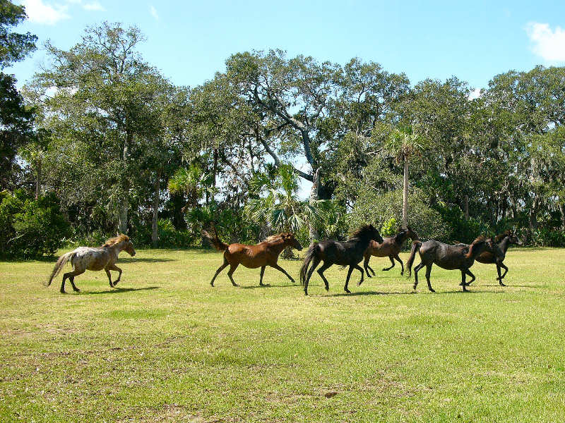
Just a couple of weeks later, on the way to GC1BFB2, me and my wife were charged by a group of six wild horses (these ones!). They weren't being aggressive towards us, they'd been spooked by the galloping arrival of another group and took off for cover - right towards us! They went around us, fortunately but they got very, very close.
At the moment, the copperhead was the scariest encounter - mere inches from a very venomous snake - but in retrospect, given the availability of anti-venom with major hospitals nearby, it was probably less dangerous than the horse encounter which could have been very bad in a place with no medical help available without calling life-flight!
-
FOUND IT!!!

<trim>
Too obvious?
I thought of that too, but I am really sure it been checked.
That was my first thought, too, as soon as I saw the photo. It looks a concrete lump as used to anchor a metal post in the ground. In which case, is the metal pole still set into the concrete and how far into the ground does it extend? If there is a cache there, and I see no reason to presume that there isn't just because it's flummoxed a bunch of finders
, then I'd be looking up inside that hole for a bison tube way up inside or perhaps a length of fishing line sitting there ready to be pulled. Of course if I'm right, the Pointy Object Debate should get itself into the wings ready for a good airing If the CO is inexperienced, I think I'd be inclined to take the D/T ratings with a large pinch of salt... It takes time to get to grips with the assumptions that surround certain ratings, like T1 = wheelchair accessible...

 about what does and what does not constitute a power trail and which caches should and should not have it enabled.
 )
)


 ]
]

Geocaching.com site update August 2nd 2011
in Geocaching HQ communications
Posted · Edited by JeremyR
Don't know if this has been mentioned or not but since the most recent site update, all TB watchlist notification emails contain the wrong URL for the link to the relevant cache page.
For example, an excerpt from one I received shortly after the update:
The link doesn't go to the cache page for 'View from Coombe Hill' as expected, it goes to some random guy's log from nearly three years ago It correct URL would be http://coord.info/GC171 All subsequent TB watchlist emails I've received contain a the URL to a seemingly random cache log from about the same time period too so something's gone wonky.
Previously there there was an old-fashioned non-coord.info link to the cache page. I can understand why you've changed but you're putting in the wrong links