


Waterboy
-
Posts
336 -
Joined
-
Last visited
Posts posted by Waterboy
-
-
Another great area not mentioned yet is Harriman State Park. I often describe this area as a mini-Adirondacks. The mountains are smaller, the lakes are smaller, but there are many similarities. It is an area where you can pick up a number of outstanding caches, and do some long, interesting hikes/backpacks.
To start with I recommend that you purchase the NYNJTC map set for Harriman-Bear Mountain Parks.
Yesterday I performed maintenance on two caches that I hid in the south-western part of this park. They were No Hints NY Style and Water Tank. The length of the hike was 12.6 miles. I did not spend time on any other caches in the area.
Other hiking caches that we have found near here include:
Nearby caches that we have not found that look interesting include:
Shelters of Harriman: Stone Memorial
Please note that this is just in one corner of Harriman. There are about a half dozen other sets that could be written up.
-
Sorry I am slow in answering this. Just came back from a hiking trip in Maine. (Plenty of hiking, not much caching.) I could say plenty on this subject, just not sure where to start.
Since you asked first about the Adirondacks I will mention two hiking caches that I found there.
Wanikaminplay Mountain Cache is about twelve miles round trip.
Indian Lake View is about eight miles round trip with a 2,100 foot elevation gain.
Leonid Cache is another good one. We approached it from the southeast (not the shortest or easiest way). Hike was about seven miles round trip with a 2,100 foot elevation gain.
Note for protocoldroid
As a hiker/backpacker first I believe the Adirondacks have the best selection of real hiking caches in the northeast.
I hope to make another answer with more good hiking caches in other sections of the northeast.
-
A question for those who do not want any more rules or regulations.
In my home state of Pennsylvania the DCNR (Department of Conservation and Natural Resources) regulates the caches in State Parks and Forests. This is true in several other states, with more to follow.
QUESTION – Is it better to have an outside agency regulate caching or to have GC.com do its own police work?
-
Congratulations!
(Particularly to Autumn)
You are showing the world what a family sport is.
-
This is from a complaint I heard from a tadpole cacher recently. It is not a new complaint, I first heard it two years ago, but at that time it was less significant.
The Complaint – I would love to place a cache in X Park, but Cacher SO-AND-SO has five of them there only a little over 0.1 mile apart. He/She/They have dominated the park, so no one else may have the fun of hiding a cache there.
Rule Change – No cacher may hide a cache with 0.5 miles of any other cache that he/she/they own. Exceptions would include various legs of a multi-cache.
In addition to the opinion of other cachers I would like to hear the opinion of the approvers. Would this rule create any hardships for them?
-
This past weekend Waterboy With Wife was joined by six others on an exciting overnight backpack. Also on the trip was retphoto, and Snowflower. Snowflower brought with her four friends.
The trip was highlighted by good company, good caches, plenty of fun, and a heavy downpour and soaking overnight.
We would appreciate it if anyone can suggest some other backpacking/camping/caching trips.
Waterboy With Wife
-
Congratulations!
We met when we were both tadpoles. I think that was about a century ago. Hope we meet again, in Jersey, Pennsylvania or Maine.
-
Congratulation!
Hope we shall meet again, and possibly try a backpack cache again.
-
Congratulation!
Sorry we have never met. Hope we do on a remote, difficult cache.
-
Please add our to the list.
Seven of our eight Pennsylvania caches are on State Game Land, southeast region. I will forward a list to KA by separate correspondence.
NOTE – In eastern Pennsylvania major portions of the Appalachian Trail are located on State Game Land.
-
Congratulations!
It seems like only yesterday you were a tadpole that I met in south Jersey. It is amazing.
-
-
Congratulations Ed!
-
Great accomplishment. Especially for someone who took the road less traveled and got lost.
-
I would like to ask all those who are interested in this backpack to please email me. The meeting spot will be the Route 850 parking area for the Appalachian Trail (N 40º19.309’ W077º4.685’ ). Please let me know the following:
1. How many in your group.
2. Where you will be coming from, and approximate time it will take to drive to the meeting spot.
3. Your experience with backpacking. IF YOU NEVER BACKPACKED THAT IS FINE. We would like to introduce you to this wonderful activity.
4. Any equipment you may need?
5. Do you have any medical problems or allergies that we should be aware of?
Please note that we expect to be out backpacking this weekend, (April 23-25) and will not be able to respond to questions.
Last Thursday and Friday we were at Cove Mountain, scouting out this area. Water in the springs near the shelter was excellent. The only problem we had is that I cannot find what looks like safe overnight parking near at the north end (Duncannon) of Cove Mountain. I am planning on an in out from the south end (Route 850).
Waterboy With Wife
-
Caution if you are planning on doing one or more of the following caches:
1. Cove Mountain Twenty-Dollar Cache
2. Cove Mountain "Lights-in-the-Night" Night-Cache
3. Cove's Measure
4. Cove's End.
Area is posted with the following:
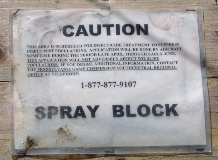
CAUTION
THIS AREA IS SCHEDULED FOR INSECTICIDE TREATMENT TO SUPRESS INSECT PEST POPULATION. APPLICATION WILL BE DONE BY AIRCRAFT SOMETIME DURING THE PERIOD LATE APRIL THROUGH EARLY JUNE. THE APPLICATION WILL NOT ADVERSELY AFFECT WILDLIFE POPULATION. IF YOU DESIRE ADDITIONAL INFORMATION,CONTACT THE PENNSYLVANIA GAME COMMISSION SOUTHCENTRAL REGIONAL OFFICE AT TELEPHONE:
1-877-877-9107
We saw this sign on the Appalachian Trail after entering from Route 850 on April 15.
-
Contratulations Harrrald!
Looking forward to meeting you again.
-
I am not acquainted with the Etrex, but the two Garmin units we own each have a “Satellite Status Page”. (We own Rino 110 and GPS-III+.) This page will tells you which satellites are being viewed by the receiver and the approximate direction of the satellites. Using this page you may figure what materials transmit the frequencies used by the GPS units.
The Satellite Status Page may be identified by looking for two concentric circles on the left side of the page and two Bar Graphs on the right side.
-
Congratulations Floopy!
-
-
CONGRATULATIONS
-
The thread appears to be only considering the inaccuracies of the GPS. I believe it is more likely with the inaccuracies with the GPS, there are still possibilities of problems with the listed distance. Some include:
1. If trail length was measured by use of a pedometer. This counts the number of steps made by a walker, and assumes all steps are of equal length and in the proper direction.
2. Calculation, copying, or entering data errors. Like the one I made above and nickbrown was kind enough to point it out.
Note – All methods of measurement have inaccuracies. The question is which has the least.
-

Truth in Advertising
Waterboy With Wife
-
Spring is here, and with spring comes maintenance of the trails and parks that the majority of geocachers use. I would like to encourage all cachers to volunteer for trail work. Common work done in spring includes:
1. Moderate brushing, clipping and clearing.
2. Painting blazes or constructing cairns.
Work requiring a team includes:
1. Major brush removal
2. Creating or re-routing trails
3. Bridge and Lean-to maintenance or construction
4. Stone work, such as creating steps on inclines
In you live in the Delaware Valley one group to contact that performs trail work is the
DV-AMC (Delaware Valley Appalachian Mountain Club).
Request cachers involved with other clubs, conferences, and organizations list them.
Loooong Geocaches
in Northeast
Posted
In northwestern Jersey the Kittatinny Ridge offers many hiking caches. For a good map of this area please check the Kittatinny Ridge maps by the NYNJTC. Perhaps the most popular over the last two years has been a roughly ten mile hike to pick up Helispot and Dreamcatcher. A recent addition to this loop is Rob’s Invite. Some hiking cachers will walk an additional three or so miles to pick up No Hints Bridges the Gap.
Again, I am trying to get you to go to two of my caches, Helispot and No Hints Bridges the Gap.
WATERBOY WITH WIFE