


Waterboy
-
Posts
336 -
Joined
-
Last visited
Posts posted by Waterboy
-
-
This is an easy multi cache so it says. The GC that was given was N44.15.781 and W076.34.520. When I come home and put the coordinates in on Vantage software it then shows the waypoint next to the multi cache I got the coordinates from but on the GPS the coordinates of the waypoint changed to N44.26302 and W 076.57533. I do not know how this is happening.

I am not sure I follow this completely, but it appears that you are mixing up units in Degrees-Decimal Degrees (hdd.ddddd˚) and Degrees-Minutes-Decimal Minutes (hdd˚mm.mmm’). Simply put N44˚15.781’ and N44.26302˚ are the same. Also W076˚34.520’ and W076˚57533 are also the same. Please check this out.
-
As two old geocachers, who are very active in hiking we must say that we only just discovered that Brian has a problem. (We are not regular readers of the forums.) Brian is a great person and every geocacher owes him something, he helped develop geocaching in this area. Brian is also a trail maintenance supervisors, thus every hiker owes him something also. Brian, if you need help with your caches, let us know by email. Also if you are planning a caching trip to the fair state of Pennsylvania, possibly we can meet and cache together once again.
Waterboy With Wife
-
Yesterday Walkin’ Ed did plenty of walkin to find number 2,000, the Yesterday Walkin’ Ed did plenty of walkin to find number 2,000, the New York/New Jersey Multi-State Multi-Cache (GC3CBF). Also picked up a few other respectable caches along the way.
Waterboy With Wife
-
On the third day of the third month of this year polskikrol and ThirstyMick did plenty of hiking, and picked up eight caches of some extremely difficult.
This list of caches:
Ravine (GCYBXH)
Dam Monk (GCRZJ1)
Covert-002 (GC6DB)
Schooley's Cache (GCD70)
Rob's Invite (GCJ4B8)
Helispot (GC276E)
Dreamcatcher (GC5F8)
Don't Let The Bears Get Ya (GCN4NG)
Those of you who know my wife and I know that we love good hiking caches. From a hiking point of view, there are no tougher non-multi caches than Dreamcatcher and Helispot in the state of New Jersey. Covert-002 is not far behind. Don’t Let The Bears Get Ya and Rob’s Invite are definitely respectable. Hope someone else will comment on the other three since I just do not know them.
On the same day Waterboy With Wife were out and went by Rob’s Invite and performed maintenance on Helispot. Conditions were icy, making polskikrol and ThirstyMick odyssey more impressive.
Waterboy With Wife
-
Since you are asking for the calculations in feet, I assume that you are talking short distances, less than two miles. A set of equations that you could use for a spherical approximation follow:
L1 = Latitude of Point 1
λ1 = Latitude of Point 1
L2 = Latitude of Point 2
λ2 = Latitude of Point 2
The distance north/south in feet will be:
ΔL = 364566*( L1 - L2 )
The distance east/west in feet will be:
Δλ = 364566*( λ1 - λ2 )*cos(( L1 + L2 )/2)
Using the Pythagorean Theorem the distance may now be calculated as:
Dist = SQRT(ΔL*ΔL + Δλ*Δλ)
Notes:
1. Coordinates should be expressed in decimal degree format.
2. This method will give you fairly accurate results on distances up to 10 miles.
3. These calculations should not be used if you are caching in extreme polar coordinates, like latitudes above 87º.
4. Despite what you may read in these forums no system of distance calculation is completely accurate, surveyors have compared them to actual measured conditions. There are some methods of calculation that the error is less than one part in ten thousand.
5. If you understand what I wrote above, it should be no problem putting it on a spreadsheet. However, it will take time. Be careful on using the correct format on all angles.
6. You may find it easier if you use UTM coordinates. Although accuracy using these coordinates drops as you approach a different zone (at Longitudes of -72º, -78º, -84º, -90º, -96º,…..). It would also be inaccurate in extreme polar coordinates.
-
-
Short notice. But I will be going on a short backpack next weekend 19-21. It will be on the AT in pa. from rte 309 to Bake Oven Knob shelter and back. We will be night hiking in to New Tripoli campsite friday night. Then go to Bake Oven Knob shelter Saturday and back to Rte. 309 Sunday. Long range forcast looks like we might have some winter weather. This will be about a 12 mile round trip hike. There are caches along the route to be had. If the weather is nice there are some nicve views to be had also. If interested let me know and I'll get more information to you.
Excellent choice TeamHopewell. Although there is not much of an elevation change on this stretch it is one of the rockiest and nastiest sections. It also has some good views. Wish we could join you, but it conflicts with other plans.
Waterboy With Wife
-
Thanks for the link. That is quite a site.
Waterboy With Wife
-
I remember something called “winter” from my youth. Unfortunately I have not seen anything like it for a couple of years. Do you think you could define the word “winter”?
Waterboy With Wife
-
Remember the original plan was written ten year ago. Geocaching did not exist at that time, and is therefore not mentioned. Lets make sure New Jersey officials do not forget our new and wonderful sport.
-
Please attend one of the "Open Houses" where "the public is invited to learn about the Trails Plan and share perspectives on trail issues and the future of trails in NJ."
Tuesday, September 19, 2006 (3:30 to 7:30 pm) At the Frelinghuysen Arboretum
53 Hanover Avenue, Whippany, NJ
If you are closer to Trenton:
Tuesday, September 26, 2006 (3:30 to 7:30) At the Ellarslie Museum Cadwalader Park, Trenton, NJ
REMEMBER, Jersey is interested in tourists also.
We are Pennsylvania residents, that hike and cache in Jersey often and stated this on the survey when we completed it.
Waterboy With Wife
-
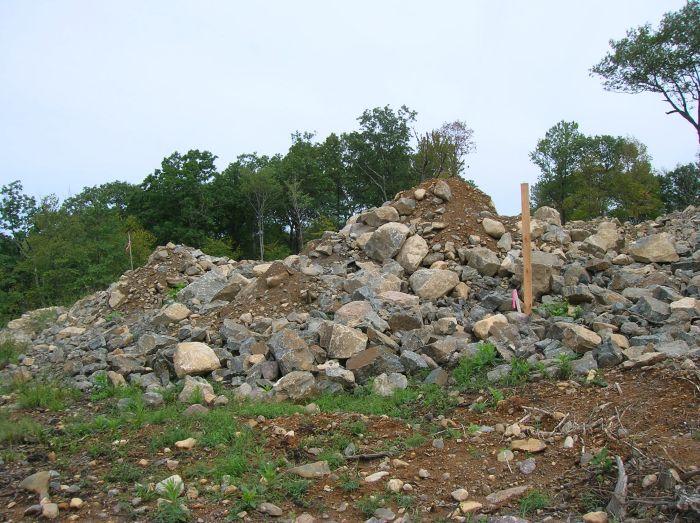
Urbanization is about to end the life of one of New Jersey’s greatest hiking caches, Splitrock Overlook by Team Magster. Urbanization is about to end the life of one of New Jersey’s greatest hiking caches, Splitrock Overlook by Team Magster. We hiked past this superb cache on August 31, and saw construction of large, expensive housing only a few feet from the cache. We went down and checked that the cache is still located where it always was. Now we regretfully suggest that Team Magster either:
A. Remove and archive this cache
B. Relocate this cache
I hope the Magster will make choice B. This cache has some of our fondest memories.
Since our memories are linked with those of Mopar and Geo Ho I hope they will write something into this thread.
Thank you Team Magster for an excellent cache and for great memories.
Attached is a photo taken near the cache of the construction site.
Waterboy With Wife
-
-
Although we can think of nothing “good” about a plane crash, it may be what you are looking for. This article describes one on Wright Peak in the Adirondacks. There is still plenty of debris in the area.
Waterboy With Wife
-
On July 3 I went after this geocache in State Game Lands 135 in Eastern Pennsylvania. Heading through Lackawanna State Forest and SGL 135 considerable destruction by the gypsy moth was observed. In May we observed a considerable number of these pests in Worlds End State Park and adjacent Loyalsock (formerly Wyoming) State Forest.
We believe misery wants company. Who else has seen this type of destruction this year?
Thank you.
Waterboy With Wife
-
Three different cachers (on two occasions) have reported sighting rattlers and the Eagles Nest geocache this year. The snakes were spotted by Lux, CCCooperAgency, rrrrriggs. If you read the old logs you will see that several were also spotted on previous years.
Waterboy With Wife
-
We like the sound of a loon's cry. (Whatever you do omit the rattle of snakes.)
Waterboy With Wife
-
Congratulations
Sorry we are late in offering this. We were away hiking and backpacking.
Waterboy With Wife
-
We did not spot a rattler, but a spotted a Copperhead today. We were scouting an area for a new cache in St. Anthony’s Wilderness (State Game Lands 211). The wife almost stepped on the snake before we saw him.
Waterboy With Wife
-
Please remember. The person who hid the cache was also off in his/her accuracy.
Waterboy With Wife
-
We are a married couple that live in eastern Pennsylvania, near the New Jersey border. We specialize in hiking caches, and rarely do any others.
Our recommendation for the best hiking cache utopia in the northeastern corner of the United States, the Adirondack area of northern New York State.
Please remember that in the Adirondacks there are two seasons every year, winter and the forth of July.
Waterboy With Wife
-
Why do we use deg min.xxx?
The only reason I know is that it is the wisdom of the ages. (Or maybe the stupidity of the ages.) Anyway it has been done this way for centuries by navigators and surveyors. Although historically sometimes we find deg min sec used instead.
Try reading some great nautical literature written in the first half of the 19th century, try Melville or Dana for the author. They will discuss, among other things the ships velocity in knots. Knots are nautical miles per hour. A nautical mile is one minute of arc on the equator.
Some other things to think about:
1. Why do we and geocaching.com use the mile (5,280 ft) instead of the nautical mile (6,076 ft)?
2. Why do we use a system that has 360 degrees, instead of a truly metric system?
If you follow my references in literature I am sure you will enjoy “Moby Dick” and “Two Year Before the Mast”.
Waterboy With Wife
-
The PGC is not run funded by tax dollars therefore all lands purchased and managed by the pgc are "private lands" for the use of pgc and it's licenced users for hunting, trapping and propagation of game species in the state of PA. they could even charge an extra fee for fishing in a lake on pgc property if they so choose.
While what ChinCache says is correct now, that might not always be the case. This article references a bill that will (amoung other things) require a $20 conservation stamp for both hunters and non-hunters that use the SGL.
Is this good or bad? I am not sure. Currently non-hunters have no voice in the running of the PGC’s policies. If cachers, hikers, bird-watcher, dog walkers, etc. are taxed, should they also be represented in the Game Commission?
-
How things have changed. I recall a cache named pm|_ by c_n|njA (Pine Meadow Lake by Cache Ninja). It was hidden on 4/7/2001. We had first find almost seven months later on 11/4/2001.
True hiking caches will often have an extra day before being found. Just yesterday I had FTF at Uh-OReviewer, I MissPlaced my cache! by DocDiTTo & Lux. Approved Sunday 4/16/06, found Tuesday 4/18/06. The weather was gorgeous during the full 48 hours that this cache sat lonely.
Something is wrong with membership
in General geocaching topics
Posted
I just received an email informing me that my member has expired. I have sent in a check for $30 on 03/15/2010 and the check cleared the bank on 04/05/2010. Who do I notify to get this corrected?