


chiknlips45
-
Posts
38 -
Joined
-
Last visited
Posts posted by chiknlips45
-
-
Here's my log for the 15th.
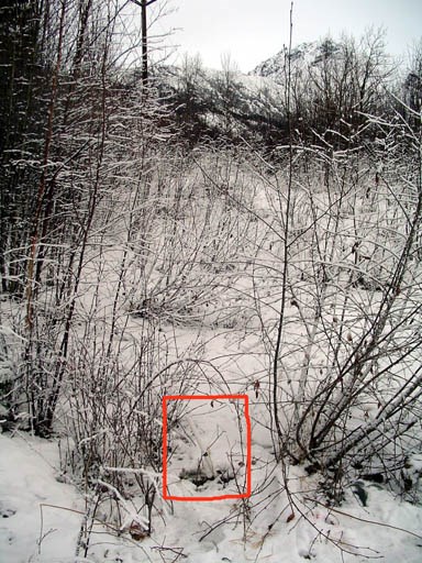
TT0828--Setting 17 20 Pts First for setting 17 +5 Pre 1960 bonus + 5 for ground covered in snow bonus.
-
Thanks Klemmer & TeddyBearMama. The Macro worked like a charm.

-
Count me in! Hopefully spring will be early this year.
-
Great photos and post. Thanks for sharing.
-
After reading this thread I felt inspired to continue searching in the winter months. Yesterday I was able to recover TT0686 but short white witness posts without signs are not the answer in this neck of the woods. I prefer orange carsonite posts myself.
-
Did you know Frosty is a Benchmark Hunter? MD0583 found durning an escape to MI during the holidays.

-
Howdy! Which station are you searching out? Want some help with a long tape & short shovel on site? I might be able to break away one evening later this week to lend a hand...
NorthWes, I'd really enjoy the help. Later on in the week may work for me but I'm not sure yet . The station is UV4396. RM3 is the only mark recovered. It was an obvious find. I had to obtain a permit from Eklutna Inc in Eagle River to tresspass on their property. I'll shoot you an E-mail with more specifics and contact information if that's OK with you?
-
Paul and Paul, thanks for the advice and recommendations. I'm sure the bearing is not reversed since the station is adjusted and my GPS zeros out in the correct direction. There's also some small stakes in the area of the main station that ensure I'm on the right track. I 'll put less emphasis on following the arrow of the reference marks and pay more attention to my compass and tape. For some reason, when on site, the excitement and thrill of the hunt tend to cloud my mind from common sense approaches to finding the station. Thanks again for the sound advice.
Mike
-
I'm currently trying to recover a station but have only one reference mark located. I do have a clear view towards the station area but if there, it's buried fairly deep. When reference marks are set, are the arrows sighted visually towards the station or are they calculated using some other means? At 57 feet away, I thought a visual alignment using the arrow would prove closer than a compass alignment if the arrow can be trusted as accurate. The reference Mark disk is solidly set. Your thoughts?
-
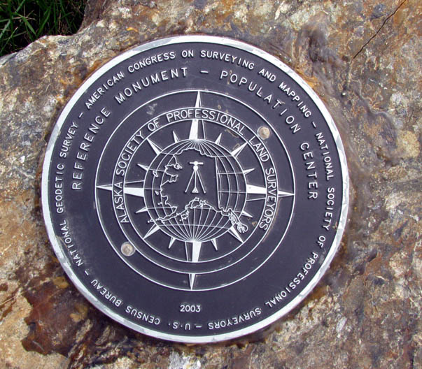
I visited the Alaska Center of Population Disk on Sunday. Coordinates I had were N 61° 34.693, W 149° 08.331 with 7 Ft of variation.
-
OK, I assigned counties / boroughs to all the Alaska datasheets that were missing counties, and updated the maps. The assignment was based on the published lat/lon of the mark and the geographic boundaries of the Alaskan county equivalents.
Thanks for your time and effort to make the changes in AK

-
Alaska has a green hat
Alaska has the misfortune that many of its datasheets don't contain county names, so their recoveries don't get added to the map. There are probably 20-30 recoveries in Alaska that aren't anywhere on the map.
edit: Oops, there are actually almost 180 Alaskan recoveries that have no place on the map because there is no county on the datasheet.
I am constantly impressed by the wealth of information provided in the forums. You've answered every question this newby has had, including why the Alaska marks weren't showing up. It never dawned on me that the missing county information was the answer. I probably already know the answer to this one but is there anything we can do to rectifying the problem?

Stack overflow message
in Website
Posted
I'm getting the stack overflow at line 235 error message also. Windows XP 2002 Home edition SP 3, IE ver 8.0.6001. Hope this helps.