


chiknlips45
-
Posts
38 -
Joined
-
Last visited
Posts posted by chiknlips45
-
-
-
Holograph, everything looks like it should now. Thanks for checking into the problem and getting everything fixed.
-
I recently found an application for smart phones called FindAControl. I used it extensively while on vacation since I was in several different states and areas. It has it's faults but for the most part I found it useful while traveling without downloading information beforehand. It also links to NGS datasheets. If interested here's the link: http://www.critigen.com/solutions/find-control.
-
I'm showing 7 recoveries between 5/31 and 6/23 that didn't get added. Is there a way to tell when a datasheet gets updated besides checking every day?
-
Did the issue with the June statistics ever get resolved or are we still waiting for the complete archive update? Thanks again for the great work on the stats. I really enjoy seeing the info every month.
-
Thanks EdrickV for taking the time to respond. What you stated makes sense to me. It's always nice to understand why something is the way it is. I was not aware of being able to view PIDs by project in DSWorld but thanks to your response I am now.
-
Thanks TillaMurphs for the kind words and thanks to all for your input. I did a little more research but it just confuses me more. The coordinates on the non-published NGS printout for TT0860 has my updated coordinates at the bottom. At least the coordinates are updated even if the datasheet is unpublished. I guess my next question is, what exactly does "Geodetic control" mean on the non-published printout? I could understand the horizontal value having no geodetic control as it isn't tied to anything else of horizontal value. The vertical having no control seems wrong since this is listed as a first order vertical station and is also listed in special pub 169 (First-order leveling in Alaska). Some of the other stations along the same line are in the DB with a full datasheet such as TT0698 and some have the non-published report such as TT0858 but both have the same first order vertical control. I did notice that the published datasheets have "U.S. NATIONAL GRID SPATIAL ADDRESS xxxxxxxxxx(NAD 83)" and the non-published sheets don't have that line. Could that be the reason it's not published?
-
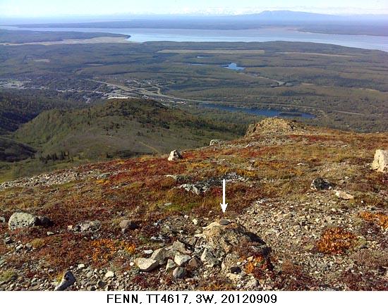
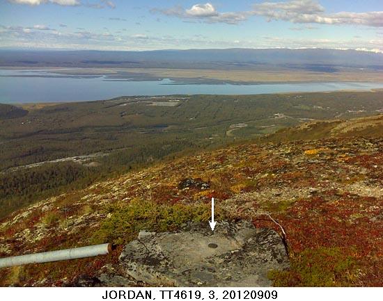
Anyone ever experience a datasheet listed on geocaching.com but not in the NGS DB? I recoved TT0860 on 13 May in good condition and filed a report using DSworld. When I went to check in the NGS DB,the datasheet was unlisted due to no Geodetic Control (Vertical and Horizontal). They called it good in 1964. Any ideas?
-
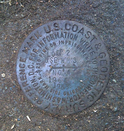
Recovered UV4446 on 10 June. I thought the tower was pretty interesting.
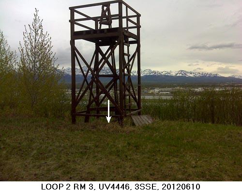
I also got a kick out of the amount of numbers on reference point 4 disk.
-
I've converted to DSWorld except adjusting the initial sizing & lighting of photos. I really like the insertion of the captions and arrows. The renaming feature reduces errors and seems very logical after a couple times using it. The ability to upload multiple photos at once is also a really nice feature. Submitting reports has become second nature and seems to work well for me. I haven't really used the Google Earth feature much since I already had my nearby counties in a KML with color coded pins specific to my liking. Initially I was reluctant and not wanting to screw up submitting reports but I wouldn't want to go back now. The one thing I would like to see adjusted is the format of the Reference Mark projection output. If it was in an easy to use format I would be more likely to use it. Overall, I think it's a really great program.
-
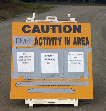
Actually, I've had real good luck avoiding bears. I attribute it to obeying posted signs, staying away from rivers during salmon runs and being very aware when the moose are calving. I also make lots of noise and always carry bear spray just in case. I've read a couple of cases where people do not obey these type of signs and bad things happen.
-
Now that is what I call a 2-fer. The only problem is which to get first.
-
Anyone ever have anything odd put an end to a search? I went looking for UV4443 today. I had waited for low tide since the station would be exposed and was looking forward to success until about a quarter mile from GZ I find this in the road:
-
Personally I'm a fan of the updated percentage map since we have several Benchmark enthusiasts in our area. This gives me an idea of how many virgin marks are still out there. Of course the original map is hard to top. Thanks again for providing us the information.
-
Artman, after messing around with Google Earth for about an hour, here's my thoughts (Not that I'm right, but here goes anyway). Measuring the distance from highway 3 NW .6 miles puts the mark approx 300 ft WNW of the scaled coords. It appears the road has shifted approx 15-20 ft but to the SW which would put the mark that much further NE of the levee road. I see the road isn't directly on top the levee so they may have added ballast to the top of the levee but hopefully SW of the road. My best guess for a location would be at N 38°33.236, W 90° 12.158 approx 20-28 ft NE of the existing levee road. I'd use the old metal detector if you have one. Since the post is probably broken off, there should be two signals to detect instead of one. Best of luck.
-
Take a look at the description for DE6036. I'd say you found DE6037 also but DE6036's location description is attached to it.
-
AJ2823 was mine. I uploaded the recovery and three photos through DSWorld. The last photo is not mine but looks like it could be from Google Street view. Has anyone else experienced additional photos?
-
There is no Benchmark icon in the Garmin units. I was able to create the custom icons in the My Documents\My Garmin\Custom Waypoint Symbols directory as stated above. With the newer Garmin units, the icons can be copied into the \Garmin\CustomSymbols directory once you link your unit to the computer. This doesn't solve the original issue of the imports being the treasure box icon, but at least I can change them once entered.
-
I have a Garmin Oregon 550t and the marks input with the treasure box icon also. Kind of confusing if you happen to be a cacher/benchmarker. Of course the latter being more fun.

-
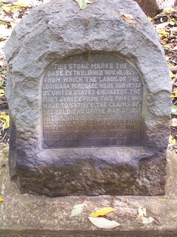
Hey Everyone, we just got back from a great weekend, where we went to the Louisiana Purchase State Park in Arkansas. I had read about the stone memorial there (which is also benchmark EH2910) in the Berntsen International Book of Survey Markers. After reading about it there and perusing GEO*Trailblazer 1's logs, I just HAD to go see it.

This marker is the beginning point of the surveys for the Louisiana Purchase. I figured my fellow benchmark enthusiasts would appreciate the historical significance of it, and may want to stop by there on your travels.
Here is the webpage for it, along with the information for it.
http://www.arkansasstateparks.com/louisianapurchase/
Wow what a coincidence. I read the post and admired the picture yesterday. Not an hour later, I was watching Aerial America on the Smithsonian channel (Arkansas episode) and they flew over the area, commented about the same mark being in the park and the historical importance of the survey. Has anyone else been looking for benchmarks during these episodes or am I a little obsessed?
-
Not sure when it occured, but I see the AK data has been broken down to match the boroughs. Thanks to holograph for posting the new data files.
-
I downloaded the new program and experienced several problems after the required reboot to finish the install. Norton anti-virus reported having the wrong version of internet explorer (Ver 5) and would not run. Internet Explorer would not start at all. I could double click the icon but nothing happened. Finally, I received an "ordinal 481 not found in eirtutil.dll" error when trying to do a system restore to undo the damage incurred above. When my computer boots it uses the above .dll and will not allow overwriting, deleting or editing of the file. Finally after ignoring the ordinal 481 error and continuing with system restore anyway, I was able to get my system back in order. Downloader beware!!
What version/date of ieframe.dll and msinet.dll do you have on your system, and what OS are you running?
ieframe.dll date 7/19/2009 file ver 7.0.6000.16890, msinet.dll not found, running XP with SP3 and IE ver 7.0.5730.13. Hope this helps.
-
I downloaded the new program and experienced several problems after the required reboot to finish the install. Norton anti-virus reported having the wrong version of internet explorer (Ver 5) and would not run. Internet Explorer would not start at all. I could double click the icon but nothing happened. Finally, I received an "ordinal 481 not found in eirtutil.dll" error when trying to do a system restore to undo the damage incurred above. When my computer boots it uses the above .dll and will not allow overwriting, deleting or editing of the file. Finally after ignoring the ordinal 481 error and continuing with system restore anyway, I was able to get my system back in order. Downloader beware!!
-
Many thanks to UNK1 for running a great contest from beginning to end. I received my consolation prize Saturday. Of course I wish the outcome would have been a lot different but sometimes unforseen circumstances take precedence on our fun. Thanks again for taking your time to make the contest enjoyable to all the participants.
 Your efforts have not gone un-noticed.

Disk Logo List
in Benchmarking
Posted
Here's one on the Gnomonclature list for R + M Conultants that needed a photo.