

n0wae
-
Posts
292 -
Joined
-
Last visited
Posts posted by n0wae
-
-
Playing the FTF game can be a lot of fun. Make sure you post the time of your FTF. It's a lot more fun when you know how close you got or lost a FTF by. I've won and lost FTFs by only 10 minutes before! This year I've had my first night encounter with another cacher going for a FTF. That was a hoot! I'd much rather meet another cacher in the field and share the FTF than get the FTF just for myself.

-
-
Hello,
I have two D700 APRS setups running on outdated GPSrs. I use a Garmin II in the car and a Garmin V in my jeep. These older GPSrs are out of sight and run 24/7 on vehicle battery power. (All I have to do is hit the beacon button on the 2M rig.) The custom wiring is a pain but when it's done it's done. I like the freedom of caching with my 76CSx without the hassle of unplugging and plugging the unit every time I get in and out of the vehicle.
In the past I have used serial to USB converters to match up older and newer technologies.
-
Great pictures Team Laxon! The Last time we were in Mesa Verde was in the late 80s. We camped for a week in a tent and it rained every day. An old woman who ran a local store said it was the most rain she had experienced in 40 years living in the area! (Figures we picked that week to camp there). Looks like you had a good time in this fascinating area. Thanks for posting the pictures.
I'm still running on 7 cylinders since my car accident. I do plan on attending the Event tomorrow so I'll see you there.
-
April 27 by DropNewCacheGetSmilie (3766 found)
Didn't know the cache was missing and was searching when a previous finder called and told me where the cache had been located. Had a hide-a-key in the car, so replaced the cache. Hope it stays!
Cache Disabled April 27 by Cache Owner (80 found)
Checked this morning and the container is missing. I will try to get replaced soon.
-
It is posts like these - and my own memories of such fun events as having to limp out of the woods in a Jeep with a broken axle (stopping every few feet to jack the vehicle up and push in the tire) - that make me not want to rent the Jeep from Avis or whoever.
... Maybe I had a "little" to do with the broken back window, but not the tie rod.That broken tie rod was RocketMans fault.
Does this group travel with an on-board welder?
I have a professional welder in my 4x4 club and he just does this on the trail.
Yeah, I think I saw RocketMan crawl under my jeep just before I had that tranny leak last year... I think we need to keep an eye on him this year!
-
I have NEVER "cheated" before, well, unless you count the times I found the cache, but the log was soaked so I was unable to sign it, I count those as a find.
But recently I found one, well almost found it. My GPS lead me to a gaurdrail. I looked around, didn't see it. There was nothing close to that except the gaurdrail. I looked all up and down the gaurdrail, and still my GPS kept pointing me to this one spot. I spoted a magnet stuck to the gaurdrale, under a post, perfect place to hide a cache, but only a magnet was there. I posted it as a found and reported that the container was missing. I hope that that counts.
Perhaps this thread will help you.
-
Note: March 31 by cacher (777 found)
Stopped today and found the new cache, signed the log. Thanks!
 March 30 by cacher (777 found)
Thanks for allowing me to log as a find! Next time in the area I will sign the log.
March 30 by cache owner (12637 found)
Replaced bullet.
March 29 by cache owner (12637 found)
Need to check up on this one.
DNF: March 29 by cacher (777 found)
I didnt have very good luck in this area today.
Started out honest. Had a relapse. Then came clean in the end.
-
Phoenix,
In making my track library I have discovered several interesting facts... Some roads on Topo maps are simply not there any more. Some mistakes were made on others, a few never existed and a whole bunch have been moved. When I first noticed that my actual GPS track left the Topo map road years ago I backtracked to the new intersection and found where the old road (now closed) faintly continued as printed on the Topo Map. Johny Park FDR118 is a prime example of this fact. The West end of the road use to intersect the county road .4 miles East of the Parachute Road T.H. but now intersects the county road .5 miles to the West. What happened is that the Forest Service closed the part of the road that ran through private property and re-routed it on F.S. property to the county road. I see this re-routing also done due to other concerns like erosion or sensitive areas that need to be protected.
Another observation I've made is that some of the FDR numbers change over time. I've got some old Forest maps with road numbers that don't match the numbers on the ground today. Then there's the dreaded road gate that suddenly pops up closing huge areas of Forest Service land. It's all in a constant state of flux.
-
Indy Jpr,
Just found your threads last night and loaded your map sets into MapSource for a look see. Wow, what a pleasant surprise to see up-to-date data and 40ft contour intervals! I'm a member of the Trailridge Runners 4x4 Club and have been mapping Colorado 4x4 roads for years. Would you like the road track library that I've made? (Could you add it to your maps?) I use Fugawi to map the 4x4 roads but my program can also export the data as Lowrance, ESRI Shape, and Text files. Having all the 4x4 roads overlayed on your maps would be fantastic! Here's a sample of some N.G. Topo work done on my GCXDDH 4x4 Cache. (click on Topo Map) There are also other links like TrailDamage that have overlayed trails on clikable maps. To get them all of these trails added to your CO map set would be something to die for!
-
These equipment reviews are helpful in deciding what to buy.
-
Hello,
I've been working with Clyde trying to figure out why GC18RGJ crashes GPSBabel when I try to export caches from GSAK to Fugawi. Apparently the placed date of this cache in a PQ is 1901! Clyde is going to let the programmers at GPSBabel know so they can address this on their end. I thought Groundspeak would like to know about it too. Does this mean this is the first Geocache!?!
 Thanks guys you do a great job!
 -
I have a friend who lives there. Perhaps he can help you.
-
-
This Spring, I am going to plant my third geocache. It will be a challenging, although short, hike as there is barely one way to get there without climbing steep rocks and thick brush on a steep slope. My fear is that because of the challenge and the relatively remote location in the Sierra Nevada Mts., maybe only one person will even bother going after it. My question is the following: What are some good swag to put in the cache that will entice people to take on the challenge? I'm not advocating anything too expensive (over $20), mind you, but something worth going after. Right now, all I have is a FTF paper certificate I copied off of the geocache U site.
A FTF prize is nice but for out of the way caches I generally look at the quality of the cache page. If some time went into making the cache page look nice then I figure the same consideration went into the cache location and placement. Enjoying the hike and scenery is just as or more important to allot of cachers as to what we find in the cache.
-
Because i am o beginner to this ,can someone help me
I try to connect my VHF with my PC to receave APRS packets and see the position to Ozi.
How i can do this.I know there is a way
I used to to use UI-View and AGWPacket engine but now i want to use all those with Ozi
Sakis
If all you want to do is receive APRS then the easiest would be to add this link to your PC at home:
aprs.fi (It uses Google Maps and even has Satellite views that you can use.)
-
I have my GPS set up so that N is always at the top of the map screen. With the compass *off* the map screen pointer should respond to the direction you are walking. (The compass should be off if you want the map arrow to *respond* to your direction of travel) If you are not walking and want to take a compass bearing turn the GPS compass on and use your compass screen. The arrow will point to magnetic North just like a magnetic compass does. This compass function should be turned off when you are walking so the map pointer will respond to the direction you are traveling instead of being "stuck on magnetic North".
-
What do you do when you want to cook the Christmas Turkey on the Webber, but it's snowing hard outside?
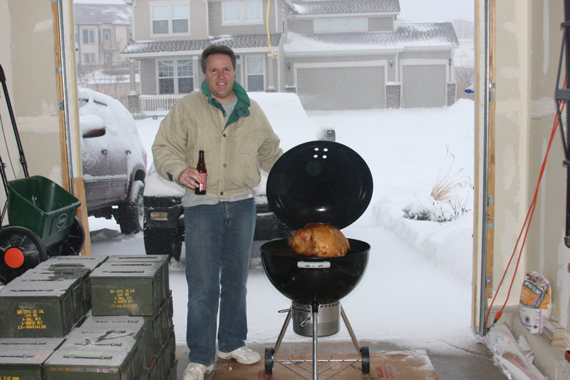
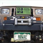
Note abundant 50 cal ammo cans awaiting more off road series next summer.
Dave, you might turn yourself into a real "RocketMan" cooking that close to all that ammo!
The snow didn't stop us from finding a few caches today after Santa left. Oh, BTW what time should we show up for dinner?
-
I almost always carry a caching pen but once in a while I forget it. (And that's when I seem to need it the most). Once I hiked back to the car to get a pen and another time I used a golf tee that was in the cache to punch 3 holes on the next line in the logbook. When I posted on-line I told the story and that the 3 holes = n0wae.
-
My story is a strange one... One of my hobbies was mapping jeep roads for myself and my jeep club. (And still is today) I bought my first GPS in 1992 when it went on sale for $1,350 (List price for the Garmin 100 was $1,795 at that time!) Hardly anyone knew what a GPS was back then.
After the GPS prices dropped and selective availability ended I remember my wife showing me a newspaper article about Geocaching. I read it and pretty much dismissed the idea as being silly. How could finding a box hidden in the woods be fun?

The years went by and at a Saturday breakfast with my Amateur Radio friends another Ham talked about finding a Geocache and that it was kinda fun. (It's all his fault!) So I thought I'd go find one myself with my newer GPS II unit....
I found it!!! It's been all downhill from there! My only regret is not being a Charter member so I could have enjoyed the addiction from the start. -
Now I know why I'm mostly a lurker in the forums!
Test Results:
Your personality type is ISTJ.
Introverted (I) 96% Extraverted (E) 4%
Sensing (S) 59% Intuitive (N) 41%
Thinking (T) 95% Feeling (F) 5%
Judging (J) 73% Perceiving (P) 27%
-
 October 4 by XXXXX (2542 found)
It looked like the actual cache container may have gone out of reach with the way things were. Put a container where it should have been, hopefully this is ok.
October 4 by YYYYY (2550 found)XXXXX and I found what we think is the main part of this hide. There was no container with it. So, together, XXXXX added a new log and I provided the new container. We both signed the log.
DNF October 3 by Honest Cacher (39 found)
Another micro not found. i spent at least 30 mins looking, and started swooning from the heat. In the fall i'd recommend taping your boots closed to keep the seeds out.
-
Google maps are such a fine tool for Geocaching. Not only do we get great maps but also satellite images to help us view GZ in all its detail. Now non-Ham licensed Geocachers can use Google maps to watch where their APRS Ham friends go via Google Maps. APRS use to be viewed exclusively by licensed Amateur Radio enthusiasts but is now open to everyone. It works similar to your GPS screen except that more than one icon (Mobil car/person) moves on the screen. Each "Ham" transmits his location apx every 3 minutes and Google Maps plots the transmitted "track points" on its maps for all to see!
It's great to see Geocaching and Ham Radio share common ground. I think it gives me a new idea for a future GeoHam cache!
-

 Thanks guys you do a great job!
 October 4 by XXXXX (2542 found)
Found It = Didn't Find It
in General geocaching topics
Posted
Some of the cachers above didn't have the new coordinates at the time of their hunt. I've been caching for a while now but still can't understand how someone can 'get permission' to find a cache that they didn't.