


PerryB2
-
Posts
60 -
Joined
-
Last visited
Posts posted by PerryB2
-
-
What limit do you have set for number of track points? From the map page > Menu button > Setup map > scroll left or right to the Track icon > is the Track Points set to 10,000?
What is the track recording method set to? Using Distance can reduce the number of track points.
-
I updated to 3.90 and took the 60CSx on a hike last week. The hike was in a wooded mountain valley. I got the Lost Reception message a couple of times. When I downloaded the track at home I found two track segments with a 1800 ft gap between.
I have not gotten the Lost Reception message before while out hiking and have not seen a gap it tracks like this before. In the past I have seen long straight segments, where I figured it had poor reception and was just connecting the dots.
Of course, this all could have been due to the particular location, but my impression is that with 3.90 it’s more willing to acknowledge poor / lost reception.
Has anyone else had a similar experience?
-
I’m wondering what does the Code Page selection list in MapsetToolkit do?
-
...
I was puzzled early on with the Colorado's backlight issue and why Garmin doesn't offer a 5 V external battery pack that could be kept in a warm location? The backlight intensity between 2.4 V and 5 V DC is significant. Does the PN-20/40 have this backlight intensity issue?
...
No. I find the PN-20 screen very readable in all daylight situations without the need for any backlight.
-
...
I think the PN-40 has a patch antenna, compared to the quad-helix in the Garmin 60CSx, or the "patch hybrid" (or whatever you want to call it) in the Garmin Oregon 400t.
I'm in forested / mountainous terrain, and I have to say that Garmin Oregon 400t regularly had difficulties in putting down a nice and consistent tracklog, when compared with the 60CSx. I don't know if this was due to the "patch hybrid" antenna it uses, or software bugs, or the inability of Garmin designers to take full advantage of the STM Cartesio chipset. In other words, it is my opinion that the 60CSx easily outperforms the Oregon 400t in terms of accuracy, which is what I'm most concerned with.
Do you have any field data that indicates that the PN-40 will at least be comparable to the 60CSx in terms of accuracy and its ability to maintain satellite locks? Will the antenna on the PN-40 be the limiting factor? (I'll assume that DeLorme has, or soon will, take full advantage of the STM chipset.)
Is it best to carry the PN-40 in a horizontal orientation? We usually strap GPS's to backpacks in a vertical orientation.
...
This may partially answer your question:
I have both a 60CSx and PN-20. The PN-20 has a patch antenna; I assume the PN-40 has the same. In difficult forested mountainous terrain carrying the PN-20 horizontal face up definitely helps in my experience (mountain valleys of WA Olympics and Cascades).
Using and REI electronics pouch attached to the shoulder strap of my pack I found it fairly easy to carry it horizontal face up.
In my experience I found the 60CSx to be a little more accurate that the PN-20. This is based on the spread of the tracks going in and coming out on the same trail. To quantify that a little on one hike the PN-20 tracks were a maximum of 70 ft apart. The 60CSx tracks were a max of 47 ft apart.
The difference between the two is small enough that when hiking in a valley the one which is on my outside shoulder (away from the hillside) often does better.
Both have produced straight track segments where presumably the reception was too poor to record a track point. Again 60CSx did this less, but the difference was fairly small.
It would not take a very big improvement for the PN-40 to match or beat the 60CSx.
-
Timpat, the only option I see for importing is "In a .gpx file that contains waypoints and/or routes in it". I do not see an option for a .gpx file with tracks. What am I missing?
“routes” is NG Topo’s term for tracks in this case. It will import them as a series of waypoints or as a line/trail.
-
What version of NG Topo are you running?
Do you have Mapsource? You can export to GPX from there and import into NG Topo. I’ve had no problems importing GPX files into NG Topo (or directly from a 60CSx). Tracks do end up as trails/lines in NG Topo; you can not then export with all the original track information.
-
Another good source for Forest Service data is the FSGeodata Clearinghouse
http://fsgeodata.fs.fed.us/clearinghouse/index.html
In an area of the Olympic NF I’ve looked at the TIGER 2007 shapefiles have lots of roads that are long gone. The FS road data is much closer to current road reality.
Anyone found a good source for land cover (woods) in vector format?
I couldn't actually figured out how to get data from that clearinghouse. It never let me select the layers I wanted to downloaded.
And I thought the USGS seamless server had a lot of land cover data.
Dan,
Thanks, let's continue the discussion on GPSFileDepot.
Perry
-
Another good source for Forest Service data is the FSGeodata Clearinghouse
http://fsgeodata.fs.fed.us/clearinghouse/index.html
In an area of the Olympic NF I’ve looked at the TIGER 2007 shapefiles have lots of roads that are long gone. The FS road data is much closer to current road reality.
Anyone found a good source for land cover (woods) in vector format?
-
I carried the GPS on my sternum strap in its Garmin Etrex carrying case so it was only blocked on one side by my body with a view of the satellites slightly back from my shoulder and all in front of me. Anytime I looked at it it appeared to have really good reception with accuracy varying from 8ft-30ft depending on tree cover, etc.
We stopped occasionally but anytime I looked down at it it did not appear to veer of randomly as if we were still moving.
If you can, you might try carrying it attached to the shoulder strap, face up to see if that improves the accuracy of the odometer.
-
HiknVA,
How were you carrying your GPS? Did you have it in your hand watching the screen the whole time? If not it may not have had good reception at times, which can result in GPS ‘wandering’ which can add to the mileage.
-
If you don’t get the help you need here, you might try posting your problem in the Yahoo map_authors forum. How are you registering your maps with MapSource? Have you tried MapSetToolKit?
-
I’ll add a little to julianh’s experiments. I’ve compared the elevation profile of a gps without auto-calibrated barometric elevation to a 60CSx with. Particularly when reception is not great the gps only elevation fluctuates a lot more. To get the best elevation profile from the 60CSx it helps to recalibrate the altimeter if the gps has been turned off for sometime…because barometric pressure may well have changed due to weather. The 60CSx will adjust for the change but it takes quite while.
-
Isn’t the Topo map in the 400T the same as Topo 2008 which you can buy and load on the 60CSx, except that the 60CSx does not show the shading? Topo 2008 has more contour detail in some areas than the older Garmin Topo map, but it’s the same as the older one in other areas.
-
<Think it's because I am not saving the track?> I don't "Save" the tracks on the GPS.
-
This past weekend I was hiking a nearby loop in a state park. To get to and from the loop I take the same trail which happens to cross a creek via bridge. Upon return I downloaded the track and noticed that my return track was shown 2 tenths of a mile upstream from where my track crossed the bridge originally. It seemed like it drifted off this distance randomly, didnt seem to follow the original path. About 10 or 15 minutes later it drifted back to original accurate track. Everything seems accurate before and after this event.
How were you carrying the GPS? Besides trees, and mountains/valleys, your body can block satellite signals…maybe enough to affect accuracy for part of the hike.
I was indeed carrying in my coat pocket, can't say for fact my body didnt effect the signal, but I do know everytime I pulled GPS out of pocket it had excellent signal, it does take several seconds to look, maybe enough time to aquire more satelites. I've also walked the same path, same coat, since several times with no issues. It does seem like you can put this HCx anyplace and it obtains decent reception.
I assume the HCx has it’s antenna above the display. To give yourself an idea about how much the body can block signals, turn on the GPS outside, let it acquire a location fix, look at the satellite bar graph page and put your had over the antenna area. You will likely see the signal strength drop very noticeably. Your hand is a lot thinner than the rest of your body.
-
I took my new Colorado 300 and my trusty 60CSx out on some local wooded trails this afternoon. I had both units strapped side by side to my sternum strap and I have to say the discrepancy between the two units is horrendous. I have been on these trails many times before and the 60CSx tracks are pretty typical of what I have seen in the past so I have to believe the accuracy of the Colorado is really bad. I also marked some WP's on along the trail and there are some points that have more than 150' difference between the two units.
I have found several caches along these trails with my 60Sx, based on the track logs I see it looks like it would be nearly impossible to find those same caches with the Colorado.
Below is a picture of a portion of the two tracks, the brown track is the 60CSx and the white is the Colorado. IS THIS NORMAL?
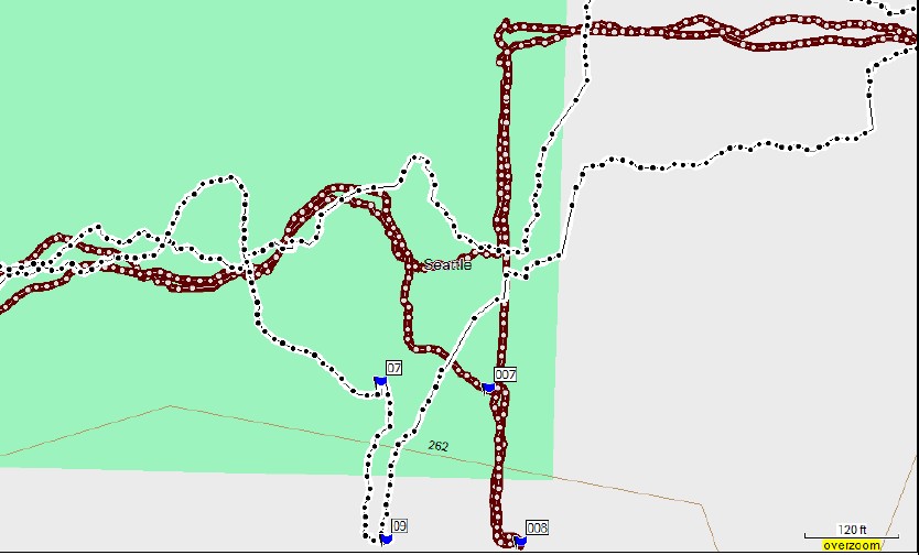
I’m not that familiar with the Colorado. What kind of antenna does it have? If it’s a patch type antenna, it may get it’s best reception horizontal face up. If a patch antenna, and if it was attached in a way that it could be facing in toward your body at times, it may have been getting very poor reception at those times…just an idea to explore.
-
On the PN-20 the Trip Odometer does not add in extra miles while the GPS is off and the track log does not either.
Right, not when its turned off but when it is turned back on in another place. It remembers where you were when you shut it off and when you turn it back on in another place it will add the distance between those two points. Try it. Example, drive 1 mile with the unit turned on, shut it off and drive back to where you started. Now turn the unit on, let it get a fix and then check your mileage on the device odometer and trip odometer. You will see 2 miles. DeLorme says this is the nature of the unit. I'm waiting for Garmin's answer on the 60cs.
Using your example, on my PN-20 the trip odometer will only show one mile. I’ve checked it. The device odometer will show two miles. I don’t know what could be different about your unit. FW version? Something in setup?
-
This past weekend I was hiking a nearby loop in a state park. To get to and from the loop I take the same trail which happens to cross a creek via bridge. Upon return I downloaded the track and noticed that my return track was shown 2 tenths of a mile upstream from where my track crossed the bridge originally. It seemed like it drifted off this distance randomly, didnt seem to follow the original path. About 10 or 15 minutes later it drifted back to original accurate track. Everything seems accurate before and after this event.
How were you carrying the GPS? Besides trees, and mountains/valleys, your body can block satellite signals…maybe enough to affect accuracy for part of the hike.
-
On the PN-20 the Trip Odometer does not add in extra miles while the GPS is off and the track log does not either.
-
Is Washington on the 'to do' list?
Thanks
-
The track log records points based on how you set it up…automatic, time, distance. So it’s results will vary from the trip odometer. If reception is poor…woods, mountains, your body blocking signals, builds, etc there will be more wandering of the track log points, particularly if it’s set to time or automatic.
-
I just tested my 60CSx. It’s been off for a few days and this is a different location than I last used it.
Out side with ¾ sky view: power on to first location fix was 33 seconds.
-
Between Garmin and DeLorme topos, the biggest difference in what you see on the GPS will be the contour line detail. Garmin is generally similar to 100k topos (depending on area 150’ intervals) and DeLorme is similar to 24k topos (at normal detail 20 ft intervals). Other posts on this forum say that Garmin Topo 2008 road locations are off by a few hundred feet in some areas. I use mine for hiking, so don’t look at the roads that much and have not noticed.
The current pn-20 bundle ‘March Madness’ price is $300. The DeLorme Topo 7 software has quite a few more features than Garmin MapSource so it does take some more time to learn…how much is hard to define…a few days?
DeLorme customer support is great. In addition to very responsive customer service, they have a user forum with active participation by DeLorme staff.
Garmin 60CSx lost reception
in GPS technology and devices
Posted
Garmin 60CSx lost reception.
When I hike I turn my 60CSx on and have it record a track log. I hike in the Cascade Mountains of Washington. Yesterday the 60CSx beeped and reported that it lost reception. It was in a valley bottom with steep ridges to the west and east, so I was not too surprised. However, as the trail went up toward more open country it still did not calculated a location.
The Satellite page just kept saying “acquiring satellites” even though for an extended period 3 satellite bars were full strength or almost, and solid color, indicating that data from those satellites had been collected. Later it was showing 4 full / almost full strength solid bars for an extended period but still was not calculation a location. Finally after 50 minutes (based on checking the track logs) it started calculating a location. It worked fine for the rest of the day.
During the time it wouldn’t calculate a location, I tried power off and on and “new location” a few times but neither helped.
Any suggestions for getting it past the “acquiring satellites” to calculating a location?
Software version is 3.60, GPS SW version is 3.00.