

Blue Canary
-
Posts
35 -
Joined
-
Last visited
Posts posted by Blue Canary
-
-
Well max zoom on MY GPS still drops the railroads off the screen if you zoom further out than .3 miles.
I know how to change the flags to dots. But when I download something from mapsource to the GPS, I would like the icons chosen while using Mapsource to stay the same. It would with my old GPS. With the new one it doesn't and it is time consuming if I have 40 or 50 waypoints to have to go back and manually change each one.
On the 76CX the parks are NOT shaded. I would like them to be as on the other GPS.
The CX does not have the calibrated compass. That is on the CSX.
I have the correct course pointer selected.
Declutter does not effect the contours.
So if I haven't selected the proper settings, and I have read and reread the book, someone tell me what sequence of buttons from which screen I need to go to get this solved.
-
I broke down a couple of months ago and bought the new Garmin GPSMAP 76Cx. Its main selling points were that it had the memory to hold all of the topo maps of the state along with some parts of the surrounding states. Also it was supposed to lock into the satelites quicker and had more waypoint storage. All this compared to my old GPS V.
1. First complaint. I use the display railroad feature regularly at work. Well if I zoom out farther that .3 miles they disappear. The old GPS let me choose at what zoom level it disappears, not the new one.
2. Second complaint. If you are in a very hilly area and zoomed out very far, the contour level lines clutter the map. Again old GPS would let me adjust this. New one doesn't.
3. Third complaint. The pointer arrow seems to wander aimlessly, almost to the point of being useless. The distance still counts down (or up) correctly. But the arrow may be pointing somewhere else.
4. Fourth complaint. I have not found a way to display the shading available on mapsource for national forest/refuge land. Old one had it, albeit in black and white.
5. When downloading a waypoint dot from mapsource, it changes the icon to a flag. If I wanted a flag, I would have chosen a flag. Flags don't show the correct location as accurately as a dot.
6. The data fields with map display have large text, which means they take up more space and reduce the amount of map being displayed. So much for having a decent map with a little data to go with it.
So what did I get for all the extra money this sucker costs when it seems to have less features. Oh I see, its got games, and a stopwatch, and calendar. Heck I thought I was buying a GPS, not a video game.
-
Ouch, that was a rude awakening. From all the advance emails asking for trades I expected pretty good sales. Now that the two main sales are past, I see that apparently most prefer to trade for their coins instead of buying them. Oh well, I guess I should have realized how it worked from my Boy Scout patch trading days.
Don't take this as a complaint, just rambling and a little advice on how things work for those of you that are thinking of taking the leap and having your own personal coins made. Remember that all the coins that don't sale must be paid for by you.
-
Reminder: The Blue Canary geocoin goes on sale Friday evening, March 31, 2006
-
Sorry, but I only have a few of the coins coming straight to me, and they are already committed to a project.
I have already had more personal emails sent to me asking for a trade than I have coins coming to me.
Blue Canary
-
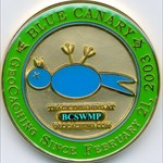
The Blue Canary geocoin is scheduled for sale March 31 and April 1 through the geocoin store. Only 375 of the coins will be sold. Here is the link to the sale http://www.geocoinstore.com/viewfullcoinde...n.php?coinid=48

The reverse of the coin has an outline of the State of Mississippi and three flags. Mississippi was admitted to the Union on December 10, 1817. On January 9, 1861 it succeeded from the Union and was admitted to the Confederate States of America on March 27, 1861. On February 23, 1870 it was readmitted to the Union. The three flags are the current flags of the United States of America and the State of Mississippi and the last official flag of the Confederate States of America.
The obverse of the coin has the logo of Blue Canary, who has been geocaching since February 21, 2003. A blue canary is a term used only half in jest by firemen in referring to law enforcement officers at a hazardous materials incident. Unfortunately, Hazmat training for law enforcement has lagged behind that of fire fighters. Law enforcement is usually trained to rush immediately to any incident they are called to. Fire fighters have been trained to observe the area as they approach. Only half jokingly, fire fighters are taught in responding to hazardous material incidents to observe any law enforcement officers already on the scene to see if the "Blue Canaries" appear OK or are prone on the ground. Blue Canary is a retired law enforcement officer.
The coin will have its own icon and is trackable on geocaching com

-
Sigh, Wanted one, but by the time the website let me in none were available
-
I found a benchmark today from an organization I can't identify. It is a standard brass disk placed in the top of a concrete pedestal. Around the top it says U. S. Engineering Dept. Mobile District. In the middle is the standard reference mark and the year 1939. Stamped around the bottom is T. T. C-1-577.
The only thing I can find on the internet is a reference that seems to imply the U S Engineering Dept was a predecessor to the Corp of Engineers.
Two questions:
1. What agency is this now.
2. Is there anyway to reference the data for this mark.
-
While I usually solo cache, I would think that group caching would be acceptable for safety reasons in some areas. Since I haven't gone after this particular cache, I don't know if it would apply for this one or not.
Blue Canary Geocoin
in Trackables
Posted
Pssst. There is still a bunch available for sale.